Broom Knowe

Hill, Mountain in Aberdeenshire

Scotland

Broom Knowe

Carn Mor Summit The Trig Point at the summit of Carn Mor 804m (Corbett)
Carn Mor Summit Credit: Ralph Greig

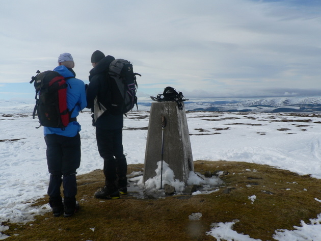
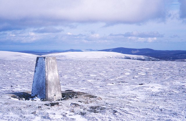
Broom Knowe is a prominent hill located in Aberdeenshire, Scotland. Situated in the eastern part of the county, it belongs to the Cairngorms National Park and forms a part of the Grampian Mountains. Rising to an elevation of approximately 720 meters (2,362 feet), Broom Knowe offers breathtaking panoramic views of the surrounding landscapes.

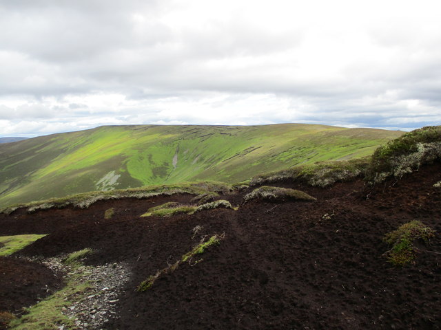
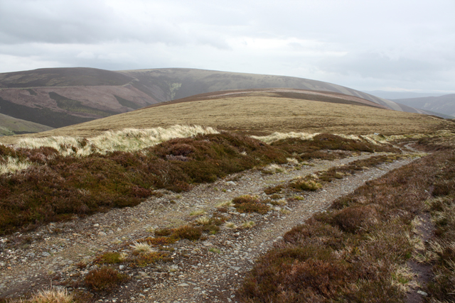
Covered in heather and grass, the hill features a gentle slope, making it accessible for hikers of various fitness levels. The terrain is mainly rocky, with some scattered boulders and outcrops along the way. The hike to the summit is relatively straightforward, with a well-defined path that meanders through the hillsides.

At the top of Broom Knowe, visitors are rewarded with magnificent vistas of the Cairngorms National Park, including the rugged peaks of the Grampian Mountains, picturesque valleys, and vast expanses of moorland. On clear days, it is even possible to catch glimpses of the North Sea in the distance.

Due to its location within the Cairngorms National Park, Broom Knowe is home to a diverse range of flora and fauna. The hillside is adorned with vibrant wildflowers during the warmer months, while various bird species can be spotted throughout the year. Wildlife enthusiasts may also have the chance to see red deer, mountain hares, and other animals that inhabit this pristine natural area.

Broom Knowe offers a peaceful and serene environment for outdoor enthusiasts seeking solace in nature. Whether it's a leisurely hike or a more challenging adventure, this hill in Aberdeenshire promises an unforgettable experience for those who venture to its summit.

If you have any feedback on the listing, please let us know in the comments section below.

Broom Knowe Images

Images are sourced within 2km of 57.245418/-3.1981627 or Grid Reference NJ2717. Thanks to Geograph Open Source API. All images are credited.

Carn Mor Summit The Trig Point at the summit of Carn Mor 804m (Corbett)
Carn Mor Summit
The Trig Point at the summit of Carn Mor 804m (Corbett)
Summit Monadh an t-Sluichd Leith A small cairn on the summit of Monadh an t-Sluichd Leith 800m (Corbett Top).
Summit Monadh an t-Sluichd Leith
A small cairn on the summit of Monadh an t-Sluichd Leith 800m (Corbett Top).
Cairns on slope of Geal Charn Mor Gentle slopes on the Ladder Hills between Strathdon and the Braes of Glenlivet.
Cairns on slope of Geal Charn Mor
Gentle slopes on the Ladder Hills between Strathdon and the Braes of Glenlivet.
Upper reaches of the Ladder Burn The Ladder Path can be seen to the left of the gully containing the burn.
Upper reaches of the Ladder Burn
The Ladder Path can be seen to the left of the gully containing the burn.
Cladonia lichens west of Dun Muir A flattish area covered in moss and lichens in the Ladder Hills.
Cladonia lichens west of Dun Muir
A flattish area covered in moss and lichens in the Ladder Hills.
Peat hags near Dun Muir A view towards Letterach from the extensive peat hags west of Dun Muir.
Peat hags near Dun Muir
A view towards Letterach from the extensive peat hags west of Dun Muir.
A Northwesterly gale buffets the Ladder Hills The back-packs acting as sails, it was impossible to walk directly along the summit plateau. Instead, a 'tacking' route was required.
A Northwesterly gale buffets the Ladder Hills
The back-packs acting as sails, it was impossible to walk directly along the summit plateau. Instead, a 'tacking' route was required.
Summit Stone I think this is the same Dun Muir summit stone shown in another photo for this grid ref. It is of a tapered shape and says "ONE" on the side shown here and on the other, something like "MAK?" or "MAN?".
Summit Stone
I think this is the same Dun Muir summit stone shown in another photo for this grid ref. It is of a tapered shape and says "ONE" on the side shown here and on the other, something like "MAK?" or "MAN?".
Snow covered track through The Ladder Hills The line of the track is very clear, with deep soft snow.  Our first food stop of the day. The snow is soft and deep, making walking a slow process unless you have snowshoes.
Snow covered track through The Ladder Hills
The line of the track is very clear, with deep soft snow. Our first food stop of the day. The snow is soft and deep, making walking a slow process unless you have snowshoes.
Dun Muir summit stone marker A small flat topped stone marking the summit of Dun Muir at 754m.  Snow not so deep and able to follow the tracks of a snowmobile
Dun Muir summit stone marker
A small flat topped stone marking the summit of Dun Muir at 754m. Snow not so deep and able to follow the tracks of a snowmobile
Trig Point summit Carn Mor Snow shoes off and planning the descent route back to Glen Nochty.
Trig Point summit Carn Mor
Snow shoes off and planning the descent route back to Glen Nochty.
Bridge crossing Allt Slochd Chaimbeil A tributary of the Water of Nochty in The Ladder Hills
Bridge crossing Allt Slochd Chaimbeil
A tributary of the Water of Nochty in The Ladder Hills
Tin Roof on shelter The corner of a corrugated tin roof with Carn Mor in background.  Track leading to Long Moss
Tin Roof on shelter
The corner of a corrugated tin roof with Carn Mor in background. Track leading to Long Moss
East ridge of Finlate Hill An estate track follows the Ladder Path here.
East ridge of Finlate Hill
An estate track follows the Ladder Path here.
Junction on Finlate Hill The Ladder Path from Duffdefiance meets an estate track here.
Junction on Finlate Hill
The Ladder Path from Duffdefiance meets an estate track here.
Howe Moss Between Finlate Hill and Dun Muir in the Ladder Hills.  An estate road follows the line of the Ladder Path here.
Howe Moss
Between Finlate Hill and Dun Muir in the Ladder Hills. An estate road follows the line of the Ladder Path here.
Estate track below Dun Muir The area south of the Ladder Hills has a large network of estate tracks.
Estate track below Dun Muir
The area south of the Ladder Hills has a large network of estate tracks.
Howe Moss Looking SE towards Finlate Hill. An estate track follows the Ladder path across Howe Moss.
Howe Moss
Looking SE towards Finlate Hill. An estate track follows the Ladder path across Howe Moss.
Show me another place!

Broom Knowe is located at Grid Ref: NJ2717 (Lat: 57.245418, Lng: -3.1981627)

Unitary Authority: Aberdeenshire

Police Authority: North East

What 3 Words

///diverting.tanked.ambitions. Near Dufftown, Moray

Related Wikis

Ladder Hills

The Ladder Hills (Scottish Gaelic: Monadh an Fhàraidh) are a range of hills in northeast Scotland which straddle the border between Aberdeenshire and Moray...

Càrn Mòr (Ladder Hills)

Càrn Mòr (804 m) is the highest mountain of the Ladder Hills on the border of Aberdeenshire and Moray, Scotland. It is located northeast of the Cairngorm...

Scalan

The Scalan was once a seminary and was one of the few places in Scotland where the Roman Catholic faith was kept alive during the troubled times of the...

Braeval distillery

Braeval distillery is a distiller of Scotch whisky in Chapeltown, Banffshire, Scotland. Founded in 1973 as Braes of Glenlivet, the distillery is owned...

Nearby Amenities

Located within 500m of 57.245418,-3.1981627
Broom Knowe
Ele: 690
Natural: peak
Lat/Long: 57.2470173/-3.19702
The data included in this document is from www.openstreetmap.org. The data is made available under ODbL.

Have you been to Broom Knowe?

Leave your review of Broom Knowe below (or comments, questions and feedback).