Baggra Yeat

Hill, Mountain in Cumberland Allerdale

England

Baggra Yeat

Augertree Fell Part of Caldbeck Common. It is just possible to make out two transmitter masts on the skyline - Sandale <a href="https://www.geograph.org.uk/gridref/NY2639">NY2639</a> (153 metres high) for DAB radio  and Caldbeck <a href="https://www.geograph.org.uk/gridref/NY2942">NY2942</a> (337 metres high) for Freeview television
Augertree Fell Credit: Oliver Dixon

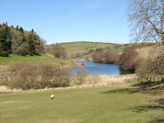
Baggra Yeat is a prominent hill located in the county of Cumberland, England. Standing at an elevation of approximately 1,538 feet (468 meters), it forms part of the magnificent Lake District National Park. The hill is situated near the village of Seathwaite and is surrounded by picturesque valleys and rugged landscapes.

Baggra Yeat offers stunning panoramic views of the surrounding countryside, making it a popular destination for hikers and nature enthusiasts. The hill is known for its challenging terrain, with steep slopes and rocky paths, providing a thrilling experience for those seeking an adventurous climb. The summit of Baggra Yeat is often shrouded in mist, adding an air of mystery to its allure.

The hill is covered in a variety of vegetation, including heather, grasses, and scattered patches of woodland. These diverse habitats support a range of wildlife, including birds, mammals, and insects. Visitors may catch a glimpse of red deer, buzzards, and the elusive red squirrel while exploring the hill's surroundings.

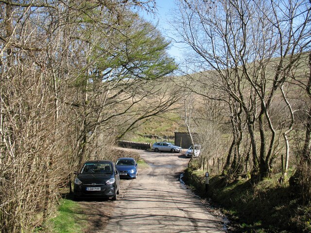
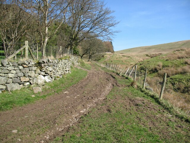
Baggra Yeat is also home to several walking trails, allowing visitors to explore the area at their own pace. The routes offer opportunities to discover hidden waterfalls, ancient stone circles, and remnants of old mining activities, providing a fascinating insight into the region's history.

With its dramatic landscapes, breathtaking views, and rich biodiversity, Baggra Yeat is a must-visit destination for anyone seeking a memorable outdoor experience in the heart of the Lake District.

If you have any feedback on the listing, please let us know in the comments section below.

Baggra Yeat Images

Images are sourced within 2km of 54.718903/-3.1382817 or Grid Reference NY2636. Thanks to Geograph Open Source API. All images are credited.

Augertree Fell Part of Caldbeck Common. It is just possible to make out two transmitter masts on the skyline - Sandale <a href="https://www.geograph.org.uk/gridref/NY2639">NY2639</a> (153 metres high) for DAB radio  and Caldbeck <a href="https://www.geograph.org.uk/gridref/NY2942">NY2942</a> (337 metres high) for Freeview television
Augertree Fell
Part of Caldbeck Common. It is just possible to make out two transmitter masts on the skyline - Sandale NY2639 (153 metres high) for DAB radio and Caldbeck NY2942 (337 metres high) for Freeview television
Caldbeck Common The skyline is dominated by Skiddaw <a href="https://www.geograph.org.uk/gridref/NY2629">NY2629</a> one of the highest mountains in England.
Caldbeck Common
The skyline is dominated by Skiddaw NY2629 one of the highest mountains in England.
Caldbeck Common Baggra Yeat Farm <a href="https://www.geograph.org.uk/gridref/NY2636">NY2636</a> nestles at the foot of Longlands Fell <a href="https://www.geograph.org.uk/gridref/NY2735">NY2735</a>.
Caldbeck Common
Baggra Yeat Farm NY2636 nestles at the foot of Longlands Fell NY2735.
Down the hill into Uldale
The Cumbria Way near Stockdale The Cumbria Way low level alternative route from Skiddaw House to Nether Row near Caldbeck follows the minor road from Orthwaite to Longlands (next photograph <a href="https://www.geograph.org.uk/photo/7192201">NY2535 : Crossroads near Stockdale</a>).
The Cumbria Way near Stockdale
The Cumbria Way low level alternative route from Skiddaw House to Nether Row near Caldbeck follows the minor road from Orthwaite to Longlands (next photograph NY2535 : Crossroads near Stockdale).
Chapelhouse Reservoir Chapelhouse reservoir impounds the waters of the River Ellen and provides water supply to west Cumbria.
Chapelhouse Reservoir
Chapelhouse reservoir impounds the waters of the River Ellen and provides water supply to west Cumbria.
Crossroads near Stockdale The crossroads is on the minor road from Orthwaite to Longlands.  The road to the left leads to Uldale, that to the right to the farm of Stockdale.
Northbound walkers on The Cumbria Way keep straight on here (next photograph <a href="https://www.geograph.org.uk/photo/7194384">NY2535 : The Cumbria Way near Stockdale</a>).
Crossroads near Stockdale
The crossroads is on the minor road from Orthwaite to Longlands. The road to the left leads to Uldale, that to the right to the farm of Stockdale. Northbound walkers on The Cumbria Way keep straight on here (next photograph NY2535 : The Cumbria Way near Stockdale).
The Cumbria Way near Stockdale The Cumbria Way low level alternative route from Skiddaw House to Nether Row near Caldbeck follows the minor road from Orthwaite to Longlands (next photograph <a href="https://www.geograph.org.uk/photo/7195725">NY2535 : Bridge over the River Ellen</a>).
The Cumbria Way near Stockdale
The Cumbria Way low level alternative route from Skiddaw House to Nether Row near Caldbeck follows the minor road from Orthwaite to Longlands (next photograph NY2535 : Bridge over the River Ellen).
The Cumbria Way near Longlands The Cumbria Way low level alternative route from Skiddaw House to Nether Row near Caldbeck follows the minor road from Orthwaite, approaching Longlands (next photograph <a href="https://www.geograph.org.uk/photo/7347321">NY2635 : Longlands</a>).
The Cumbria Way near Longlands
The Cumbria Way low level alternative route from Skiddaw House to Nether Row near Caldbeck follows the minor road from Orthwaite, approaching Longlands (next photograph NY2635 : Longlands).
The Cumbria Way near Lowthwaite The Cumbria Way low level alternative route from Skiddaw House to Nether Row near Caldbeck follows the minor road from Orthwaite to Longlands (next photograph <a href="https://www.geograph.org.uk/photo/7195684">NY2635 : The Cumbria Way near Longlands</a>).
The Cumbria Way near Lowthwaite
The Cumbria Way low level alternative route from Skiddaw House to Nether Row near Caldbeck follows the minor road from Orthwaite to Longlands (next photograph NY2635 : The Cumbria Way near Longlands).
The Cumbria Way, Lowthwaite The Cumbria Way low level alternative route from Skiddaw House to Nether Row near Caldbeck follows the minor road from Orthwaite to Longlands, climbing steeply past the entrance to Lowthwaite (next photograph <a href="https://www.geograph.org.uk/photo/7195693">NY2635 : The Cumbria Way near Lowthwaite</a>).
The Cumbria Way, Lowthwaite
The Cumbria Way low level alternative route from Skiddaw House to Nether Row near Caldbeck follows the minor road from Orthwaite to Longlands, climbing steeply past the entrance to Lowthwaite (next photograph NY2635 : The Cumbria Way near Lowthwaite).
Bridge over the River Ellen The Cumbria Way low level alternative route follows the minor road from Orthwaite to Longlands, crossing a modest bridge over the River Ellen near Riddings Plantation (next photograph <a href="https://www.geograph.org.uk/photo/7195711">NY2635 : The Cumbria Way, Lowthwaite</a>).
Bridge over the River Ellen
The Cumbria Way low level alternative route follows the minor road from Orthwaite to Longlands, crossing a modest bridge over the River Ellen near Riddings Plantation (next photograph NY2635 : The Cumbria Way, Lowthwaite).
Direction Sign – Signpost on Aughertree Fell Located on the southwest side of a road junction on Aughertree Fell in Ireby and Uldale parish. 3 arms and pawn finial. See also <span class="nowrap"><a title="http://www.geog.port.ac.uk/webmap/thelakes/photos/byh14.jpg" rel="nofollow ugc noopener" href="http://www.geog.port.ac.uk/webmap/thelakes/photos/byh14.jpg">Link</a><img style="margin-left:2px;" alt="External link" title="External link - shift click to open in new window" src="https://s1.geograph.org.uk/img/external.png" width="10" height="10"/></span> and <a title="https://www.geograph.org.uk/photo/4493258" href="https://www.geograph.org.uk/photo/4493258">Link</a>.

Milestone Society National ID: CU_NY2637
Direction Sign – Signpost on Aughertree Fell
Located on the southwest side of a road junction on Aughertree Fell in Ireby and Uldale parish. 3 arms and pawn finial. See also LinkExternal link and Link. Milestone Society National ID: CU_NY2637
Longlands Longlands is a popular starting point for walkers on the Northern Fells of the Lake District and it is often busy with parked cars.
The Cumbria Way low level alternative route, which has followed the road from Orthwaite, finally leaves the tarmac here (next photograph <a href="https://www.geograph.org.uk/photo/7347340">NY2635 : Gate at Longlands</a>).
Longlands
Longlands is a popular starting point for walkers on the Northern Fells of the Lake District and it is often busy with parked cars. The Cumbria Way low level alternative route, which has followed the road from Orthwaite, finally leaves the tarmac here (next photograph NY2635 : Gate at Longlands).
Gate at Longlands The gate gives access from the road at Longlands onto the track to Green Head.  This is the Cumbria Way low level alternative route from Skiddaw House to Nether Row near Caldbeck (next photograph <a href="https://www.geograph.org.uk/photo/7362500">NY2635 : The Cumbria Way, Longlands</a>).
Gate at Longlands
The gate gives access from the road at Longlands onto the track to Green Head. This is the Cumbria Way low level alternative route from Skiddaw House to Nether Row near Caldbeck (next photograph NY2635 : The Cumbria Way, Longlands).
The Cumbria Way, Longlands The Cumbria Way low level alternative route from Skiddaw House to Nether Row follows a track leading away from the road at Longlands (next photograph <a href="https://www.geograph.org.uk/photo/7362511">NY2635 : Track near Longlands</a>).
The Cumbria Way, Longlands
The Cumbria Way low level alternative route from Skiddaw House to Nether Row follows a track leading away from the road at Longlands (next photograph NY2635 : Track near Longlands).
Track near Longlands The track, climbing away from Longlands is an old road to Green Head and it is part of The Cumbria Way long distance path (next photograph <a href="https://www.geograph.org.uk/photo/7362901">NY2636 : Old road near Longlands</a>).
Track near Longlands
The track, climbing away from Longlands is an old road to Green Head and it is part of The Cumbria Way long distance path (next photograph NY2636 : Old road near Longlands).
Woodland edge near Longlands The woodland occupies a steep slope above a small beck and is composed mainly of larch and scots pine.  A substantial dry stone wall separates it from the open fell.
The track is an old road from Longlands to Green Head and it is the low level alternative route of The Cumbria Way long distance path (next photograph <a href="https://www.geograph.org.uk/photo/7363555">NY2736 : Old road near Longlands</a>).
Woodland edge near Longlands
The woodland occupies a steep slope above a small beck and is composed mainly of larch and scots pine. A substantial dry stone wall separates it from the open fell. The track is an old road from Longlands to Green Head and it is the low level alternative route of The Cumbria Way long distance path (next photograph NY2736 : Old road near Longlands).
Show me another place!

Baggra Yeat is located at Grid Ref: NY2636 (Lat: 54.718903, Lng: -3.1382817)

Administrative County: Cumbria

District: Allerdale

Police Authority: Cumbria

What 3 Words

///episode.outright.competing. Near Wigton, Cumbria

Related Wikis

Chapelhouse Reservoir

Chapelhouse Reservoir is a water reservoir near Uldale in Cumbria, England. == History == The reservoir, which is around 435 metres (1,427 ft) long, was...

Longlands Fell

Longlands Fell is a small fell in the northern part of the English Lake District. It is situated in the high ground known as the Uldale Fells, 5.5 kilometres...

Aughertree

Aughertree ( AF-ər-tree) is a village in northern Cumbria, England. It is situated near to the villages of Caldbeck and Torpenhow, but closer to the main...

Uldale

Uldale is a small village and former civil parish in the Cumberland district, in the ceremonial county of Cumbria, England. It is about 5 miles (8 km)...

Nearby Amenities

Located within 500m of 54.718903,-3.1382817
Barrier: cattle_grid
Source: survey
Lat/Long: 54.7221555/-3.1412143
Turpin Hill
Ele: 290
Natural: peak
Lat/Long: 54.7192126/-3.1360459
Sworley
Place: locality
Lat/Long: 54.7190795/-3.1307843
Power: pole
Lat/Long: 54.7146057/-3.1392009
Power: pole
Lat/Long: 54.7154319/-3.1386697
Power: pole
Lat/Long: 54.7162426/-3.1381592
Power: pole
Lat/Long: 54.7172395/-3.1378264
Power: pole
Lat/Long: 54.7182005/-3.1374358
Power: pole
Lat/Long: 54.7190744/-3.1378223
Power: pole
Lat/Long: 54.7197823/-3.1381489
The data included in this document is from www.openstreetmap.org. The data is made available under ODbL.

Have you been to Baggra Yeat?

Leave your review of Baggra Yeat below (or comments, questions and feedback).