Broom Hill

Hill, Mountain in Peeblesshire

Scotland

Broom Hill

Cloud shadows in upper Glen Sax Seen from the ridge N of Birkscairn Hill. The skyline is the high ground between Glenrath Heights and Hundleshope Heights.
Cloud shadows in upper Glen Sax Credit: Jim Barton

Broom Hill is a prominent hill located in Peeblesshire, a historic county in the Scottish Borders region of Scotland. Situated near the town of Peebles, Broom Hill is a popular destination for outdoor enthusiasts and nature lovers.

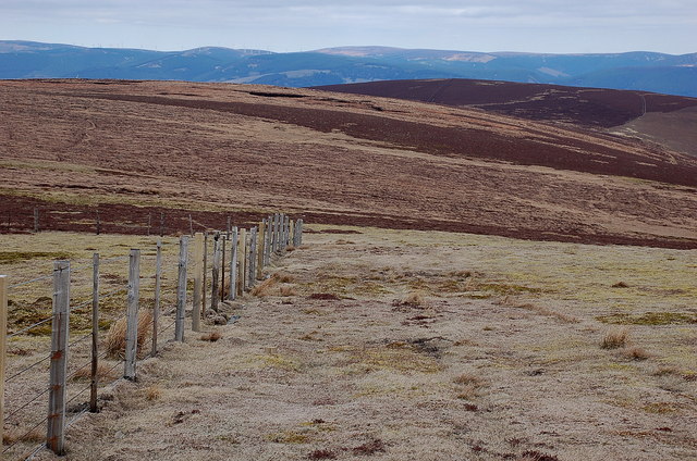
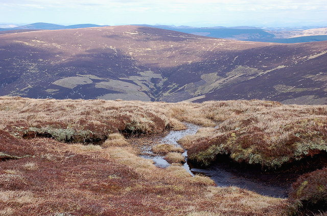
Rising to an elevation of approximately 300 meters (984 feet), Broom Hill offers breathtaking panoramic views of the surrounding countryside. The hill is characterized by its gentle slopes, which make it accessible to hikers and walkers of various skill levels. The well-maintained trails leading up to the summit provide an enjoyable and scenic experience for visitors.

The hill is covered in a mixture of heather, grasses, and shrubs, creating a vibrant and diverse natural environment. Broom Hill is also home to a variety of wildlife, including birds, rabbits, and occasionally larger mammals such as deer. Birdwatchers will find a wealth of species to observe, making it a popular spot for birdwatching enthusiasts.

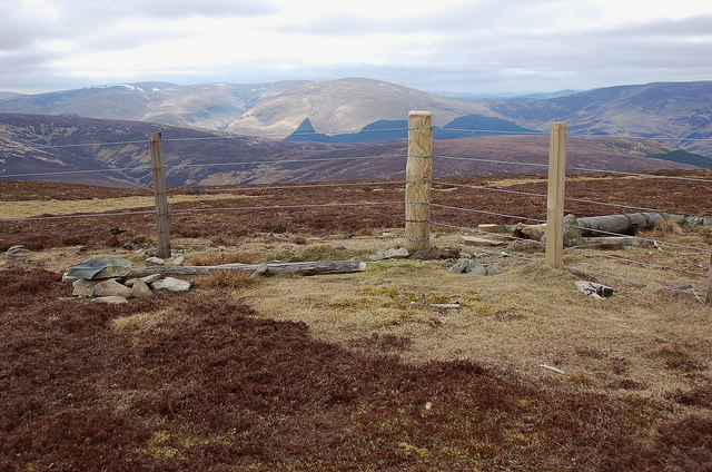
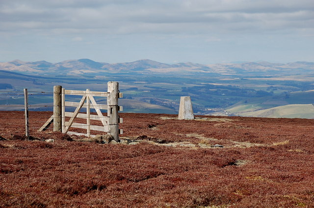
At the summit of Broom Hill, there is a small cairn, providing a point of interest for those who reach the top. On clear days, the views from the summit extend for miles, offering glimpses of the surrounding hills, valleys, and the picturesque town of Peebles.

Broom Hill offers a peaceful and tranquil escape from the bustling town nearby, allowing visitors to immerse themselves in the beauty of the Scottish countryside. Whether it's a leisurely stroll or a more challenging hike, Broom Hill provides an opportunity to connect with nature and enjoy the stunning landscapes that Peeblesshire has to offer.

If you have any feedback on the listing, please let us know in the comments section below.

Broom Hill Images

Images are sourced within 2km of 55.583609/-3.2065046 or Grid Reference NT2432. Thanks to Geograph Open Source API. All images are credited.

Cloud shadows in upper Glen Sax Seen from the ridge N of Birkscairn Hill. The skyline is the high ground between Glenrath Heights and Hundleshope Heights.
Cloud shadows in upper Glen Sax
Seen from the ridge N of Birkscairn Hill. The skyline is the high ground between Glenrath Heights and Hundleshope Heights.
Dun Rig summit and trig point Approaching by the fence from Stake Law.
Dun Rig summit and trig point
Approaching by the fence from Stake Law.
Trig point S1571 Dun Rig summit Dun Rig is the highest summit (744m) in the hills east of the Manor Valley and north of St Mary's Loch. The OS column carries a plaque with the notice:

This monument forms part of the Ordnance Survey National
GPS Network
It is an offence to damage it
If found damaged please ring our helpline on
08456 05 05 05
Thank you
July 1999
Trig point S1571 Dun Rig summit
Dun Rig is the highest summit (744m) in the hills east of the Manor Valley and north of St Mary's Loch. The OS column carries a plaque with the notice: This monument forms part of the Ordnance Survey National GPS Network It is an offence to damage it If found damaged please ring our helpline on 08456 05 05 05 Thank you July 1999
Peaty ground at Dun Rig summit Peat hags just W of the summit trig point.
Peaty ground at Dun Rig summit
Peat hags just W of the summit trig point.
Southwest from Dun Rig summit These hills are not the most spectacular mountain ridges that Scotland has to offer, but they do give a sense of space and solitude - I saw only a group of 4 people in the distance on this 7-hour walk around the Glen Sax hills.
Southwest from Dun Rig summit
These hills are not the most spectacular mountain ridges that Scotland has to offer, but they do give a sense of space and solitude - I saw only a group of 4 people in the distance on this 7-hour walk around the Glen Sax hills.
Upper Glen Sax from Glenrath Heights The ridge carrying the Old Drove Road to Peebles is above R in the middle distance, with the plantations of Glentress Forest beyond.
Upper Glen Sax from Glenrath Heights
The ridge carrying the Old Drove Road to Peebles is above R in the middle distance, with the plantations of Glentress Forest beyond.
Col at Glenrath Heights Seen from Strummeadow Hill, with the headwaters of the Glensax Burn on the left.
Col at Glenrath Heights
Seen from Strummeadow Hill, with the headwaters of the Glensax Burn on the left.
Summit fence, Middle Hill Renewed fence at the summit, with Dollar Law and Cramalt Craig (with the snow) in the background.
Summit fence, Middle Hill
Renewed fence at the summit, with Dollar Law and Cramalt Craig (with the snow) in the background.
Hundleshope Heights from Middle Hill The route to Hundleshope Heights - the darker area of heather - keeps straight on here while the fence swings left towards Broom Hill and Stob Law. The Bowbeat wind farm is visible on the skyline.
Hundleshope Heights from Middle Hill
The route to Hundleshope Heights - the darker area of heather - keeps straight on here while the fence swings left towards Broom Hill and Stob Law. The Bowbeat wind farm is visible on the skyline.
Birkscairn Hill from Broom Hill Looking across Glen Sax to the Old Drove Road crossing Birkscairn below the summit.
Birkscairn Hill from Broom Hill
Looking across Glen Sax to the Old Drove Road crossing Birkscairn below the summit.
Dun Rig from Hundleshope Heights Dun Rig is the name on the map given to the ridge in view, but is also applied to the summit of the hill itself.
Dun Rig from Hundleshope Heights
Dun Rig is the name on the map given to the ridge in view, but is also applied to the summit of the hill itself.
Hundleshope Heights trig point The trig point is just inside this square and is a few metres below the true summit, which is marked by a small cairn out of shot on the left. The Pentland Hills make a shapely skyline to the north.
Hundleshope Heights trig point
The trig point is just inside this square and is a few metres below the true summit, which is marked by a small cairn out of shot on the left. The Pentland Hills make a shapely skyline to the north.
Summit cairn, Hundleshope Heights The small cairn that marks the highest point. Arthur's Seat in Edinburgh is just visible on the skyline, left of the trig point.
Summit cairn, Hundleshope Heights
The small cairn that marks the highest point. Arthur's Seat in Edinburgh is just visible on the skyline, left of the trig point.
Cloud shadows in Waddens Hope, Glen Sax Light and shade on the patchwork heather of the hillsides here and on the plantations across the Tweed in Glentress Forest. The rocky peak catching the sun is Newby Kipps.
Cloud shadows in Waddens Hope, Glen Sax
Light and shade on the patchwork heather of the hillsides here and on the plantations across the Tweed in Glentress Forest. The rocky peak catching the sun is Newby Kipps.
Rock outcrop by Glensax Burn On rare occasions in these hills the underlying rock can be exposed in steep sections like this, where the burn has eroded into the bank. The track up the glen crosses to the other side to avoid this, and recrosses back higher up.
Rock outcrop by Glensax Burn
On rare occasions in these hills the underlying rock can be exposed in steep sections like this, where the burn has eroded into the bank. The track up the glen crosses to the other side to avoid this, and recrosses back higher up.
Track in upper Glen Sax There is a small patch of snow lingering in Middle Hinty Cleuch.
Track in upper Glen Sax
There is a small patch of snow lingering in Middle Hinty Cleuch.
Cleuch on Scawd Law A cleuch on the SE side of Scawd Law, not named on the 1:25,000 map. The snow patches are at about 550m.
Cleuch on Scawd Law
A cleuch on the SE side of Scawd Law, not named on the 1:25,000 map. The snow patches are at about 550m.
Upper Glen Sax Steep slopes above the Glensax Burn seen from the hillside N of Middle Hinty Cleuch.
Upper Glen Sax
Steep slopes above the Glensax Burn seen from the hillside N of Middle Hinty Cleuch.
Show me another place!

Broom Hill is located at Grid Ref: NT2432 (Lat: 55.583609, Lng: -3.2065046)

Unitary Authority: The Scottish Borders

Police Authority: The Lothians and Scottish Borders

What 3 Words

///disengage.crumple.lighter. Near Peebles, Scottish Borders

Related Wikis

Manor Hills

The Manor Hills, also known as the Tweedsmuir Hills, are a range of hills south of Peebles in the Scottish Borders, one of the ranges which collectively...

Dun Rig

Dun Rig is a hill in the Manor Hills range, part of the Southern Uplands of Scotland. It is the highest hill in the northernmost cluster of the Manor Hills...
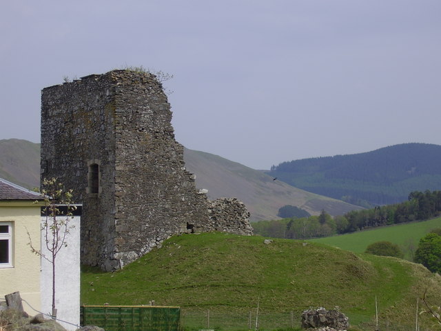
Castlehill Tower

Castlehill Tower, also known as Castle Hill of Manor, is a ruined oblong tower house dating from the end of the 15th century, situated in the parish of...

Posso Tower

Posso Tower is a 16th-century tower house, about 6.0 miles (9.7 km) south and west of Peebles, Scottish Borders, Scotland, and west of Manor Water. �...

Lyne Water

The Lyne Water is a tributary of the River Tweed that rises in the Pentland Hills of southern Scotland at Baddinsgill Reservoir. It runs through West Linton...

Manor, Scottish Borders

Manor is a parish in Peeblesshire in the Scottish Borders, whose church lies on the west bank of Manor Water 3 miles south-west of Peebles.The parish...

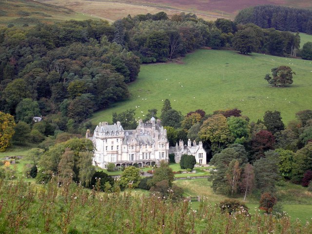
The Glen, Scottish Borders

The Glen, also known as Glen House, is an estate and country house in the parish of Traquair, southern Scotland. It is located in the glen of the Quair...

John Buchan Way

The John Buchan Way is a walking route from Peebles to Broughton in the Scottish Borders, a distance of approximately 22 km (13 miles). The route is waymarked...

Nearby Amenities

Located within 500m of 55.583609,-3.2065046
Broom Hill
Ele: 720
Natural: peak
Lat/Long: 55.5835533/-3.2064148
The data included in this document is from www.openstreetmap.org. The data is made available under ODbL.

Have you been to Broom Hill?

Leave your review of Broom Hill below (or comments, questions and feedback).