Kiddam Hill

Hill, Mountain in Dumfriesshire

Scotland

Kiddam Hill

Logging road, Strushel Like much of Eskdalemuir's forestry at this time, trees at a young stage in the growth cycle.
Logging road, Strushel Credit: Richard Webb

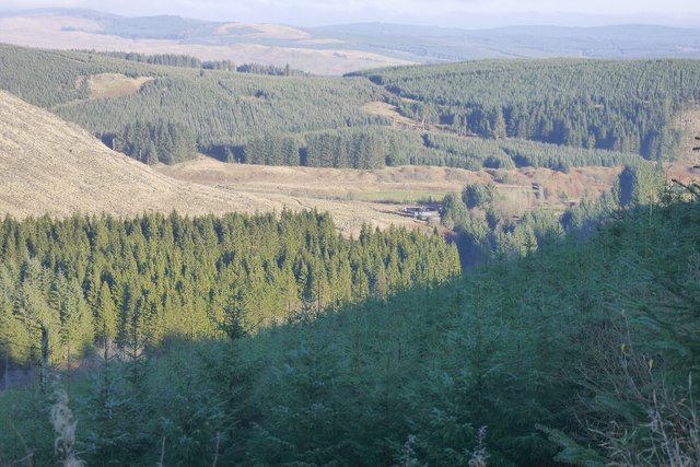
Kiddam Hill is a prominent hill located in Dumfriesshire, Scotland. Rising to an altitude of approximately 377 meters (1,237 feet), it is considered a notable landmark in the region. Situated near the village of Holywood, Kiddam Hill offers breathtaking panoramic views of the surrounding countryside.

The hill is characterized by its gently sloping sides and a prominent summit, making it an ideal location for outdoor enthusiasts and hikers. The terrain is mostly covered with grass and heather, creating a picturesque landscape that changes colors with the seasons. Visitors can enjoy a variety of flora and fauna as they explore the hill, with an abundance of wildflowers, including heather and bluebells, dotting the landscape.

Kiddam Hill is known for its historical and cultural significance as well. The hill has been inhabited since ancient times, and remnants of prehistoric settlements and structures have been discovered in the area. Additionally, the hill is associated with local folklore and legends, adding to its mystique.

Access to Kiddam Hill is relatively easy, with a well-marked footpath leading to the summit. The route is suitable for individuals of varying fitness levels, although caution is advised as the terrain can be uneven in certain areas. Once at the top, visitors are rewarded with stunning views of the surrounding countryside, including the rolling hills, quaint villages, and distant mountains.

Overall, Kiddam Hill offers both natural beauty and historical significance, making it a must-visit destination for those exploring Dumfriesshire.

If you have any feedback on the listing, please let us know in the comments section below.

Kiddam Hill Images

Images are sourced within 2km of 55.312345/-3.2526902 or Grid Reference NT2002. Thanks to Geograph Open Source API. All images are credited.

Logging road, Strushel Like much of Eskdalemuir's forestry at this time, trees at a young stage in the growth cycle.
Logging road, Strushel
Like much of Eskdalemuir's forestry at this time, trees at a young stage in the growth cycle.
Quarry above the Strushel Burn Beside the logging road which contours the slope south of the Strushel burn in Eskdalemuir Forest.
Quarry above the Strushel Burn
Beside the logging road which contours the slope south of the Strushel burn in Eskdalemuir Forest.
Clearfell on Mid Rig Looking over the Big Strushel Burn in Eskdalemuir Forest. Loch Fell in the background.
Clearfell on Mid Rig
Looking over the Big Strushel Burn in Eskdalemuir Forest. Loch Fell in the background.
Track junction, Spots Law Rig Logging roads meet above the Big Strushel Burn in Eskdalemuir Forest.
Track junction, Spots Law Rig
Logging roads meet above the Big Strushel Burn in Eskdalemuir Forest.
Kiddam Hill Recently clearfelled. The mapped wide ride is clearly visible.
Kiddam Hill
Recently clearfelled. The mapped wide ride is clearly visible.
Eskdalemuir Forest: The Powdanna Burn Mostly clearfell and young trees, so the burn and an old stell beneath Spot Law Rig are visible.
Eskdalemuir Forest: The Powdanna Burn
Mostly clearfell and young trees, so the burn and an old stell beneath Spot Law Rig are visible.
Kiddam Hill Recently clear felled with a new track visible.
Kiddam Hill
Recently clear felled with a new track visible.
Kiddamhill Former farm on the Garwald Water and Powdanna Burn.
Kiddamhill
Former farm on the Garwald Water and Powdanna Burn.
Forestry road, above Rispy Cleuch There is a lot of windthrow in the older trees above the road. Quite an exposed location.
Forestry road, above Rispy Cleuch
There is a lot of windthrow in the older trees above the road. Quite an exposed location.
Logging road, Ashy Bank A dead end, but if you are determined it is possible to walk along a rough ride from the end to another road end.  As far as you can see, conifer plantations.
Logging road, Ashy Bank
A dead end, but if you are determined it is possible to walk along a rough ride from the end to another road end. As far as you can see, conifer plantations.
A road end From here it is possible with determination to get through to another road end via White Hole along a ride. The area is mostly covered with young trees.
A road end
From here it is possible with determination to get through to another road end via White Hole along a ride. The area is mostly covered with young trees.
Road over Ashy Bank Looking along a logging road from the turning circle at its end.
Road over Ashy Bank
Looking along a logging road from the turning circle at its end.
Ride, Ashy Bank An unplanted strip of unutterable roughness heading for another logging road spur end beyond White Hole.
Ride, Ashy Bank
An unplanted strip of unutterable roughness heading for another logging road spur end beyond White Hole.
Felling, Whitehope Rig Forestry Commission woodland, part of the 1940s Twiglees Forest.
Felling, Whitehope Rig
Forestry Commission woodland, part of the 1940s Twiglees Forest.
View from The Snout Looking down the Garwald Water from a logging road on The Snout, Eskdalemuir Forest.
View from The Snout
Looking down the Garwald Water from a logging road on The Snout, Eskdalemuir Forest.
Wetwood Hill Newly replanted hill above the Garwald Water. Beyond the trees go on, and on.
Wetwood Hill
Newly replanted hill above the Garwald Water. Beyond the trees go on, and on.
Eskdalemuir Forest Wetwood Hill and beyond, seen across the Garwald Water.
Eskdalemuir Forest
Wetwood Hill and beyond, seen across the Garwald Water.
Eskdalemuir Forest, south of the Garwald Water Usual tightly planted Sitka spruce.
Eskdalemuir Forest, south of the Garwald Water
Usual tightly planted Sitka spruce.
Show me another place!

Kiddam Hill is located at Grid Ref: NT2002 (Lat: 55.312345, Lng: -3.2526902)

Unitary Authority: Dumfries and Galloway

Police Authority: Dumfries and Galloway

What 3 Words

///pylon.ivory.charted. Near Moffat, Dumfries & Galloway

Nearby Locations

Kiddam Hill Rispy Cleuch

Related Wikis

Eskdalemuir Forest

Eskdalemuir Forest is a forest north of Eskdalemuir, Dumfries and Galloway, in southern Scotland. It was created as a private enterprise by the Economic...

Eskdalemuir Observatory

The Eskdalemuir Observatory is a UK national environmental observatory located near Eskdalemuir, Dumfries and Galloway, Scotland. Along with Lerwick and...

Ettrick Pen

Ettrick Pen is a hill in the Ettrick Hills range, part of the Southern Uplands of Scotland. A remote peak, It lies southwest of the village of Ettrick...

Kagyu Samye Ling Monastery and Tibetan Centre

Kagyu Samye Ling Monastery and Tibetan Centre is a Tibetan Buddhist complex associated with the Karma Kagyu school located at Eskdalemuir, Scotland....

Nearby Amenities

Located within 500m of 55.312345,-3.2526902
Ele: 387
Natural: peak
Lat/Long: 55.3123627/-3.2524232
The data included in this document is from www.openstreetmap.org. The data is made available under ODbL.

Have you been to Kiddam Hill?

Leave your review of Kiddam Hill below (or comments, questions and feedback).