Dunnet Head

Hill, Mountain in Caithness

Scotland

Dunnet Head

Many Lochs A view of the middle of the three lochs.
Many Lochs Credit: David Bremner

Dunnet Head is a prominent hill located in the county of Caithness, in the northernmost part of the Scottish mainland. Standing at an elevation of 82 meters (269 feet), it is often referred to as the northernmost point of mainland Britain. The hill offers breathtaking panoramic views of the surrounding coastline, making it a popular destination for nature enthusiasts and tourists alike.

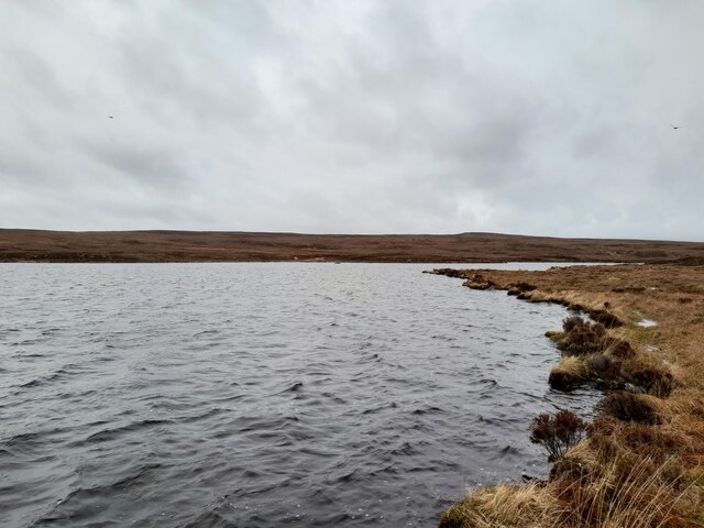
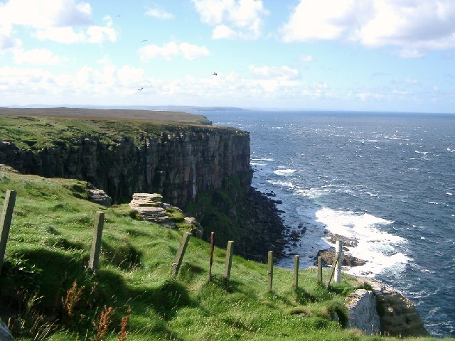
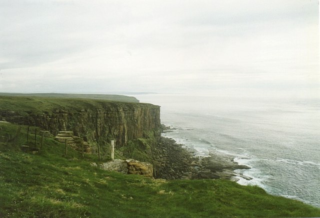
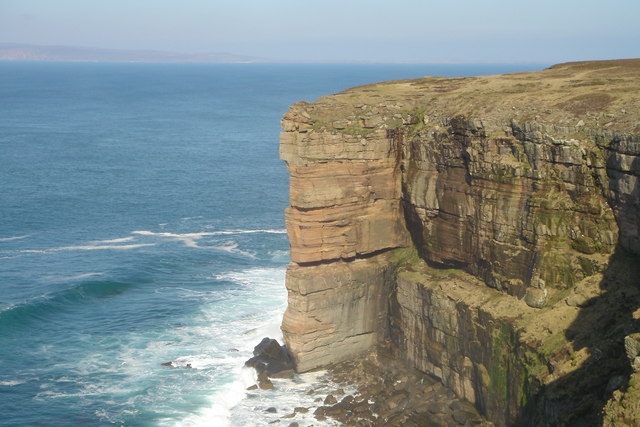
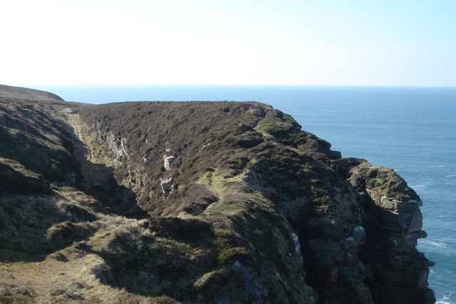
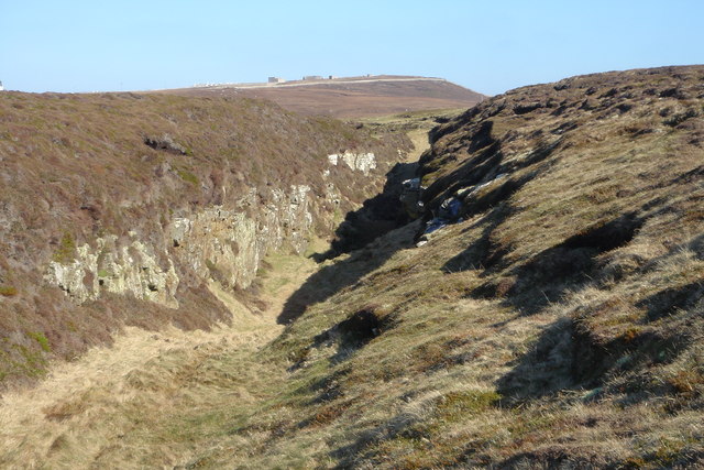
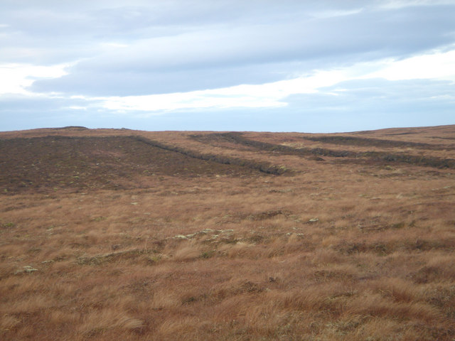
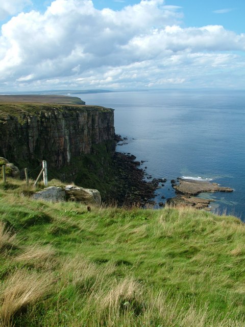
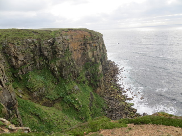
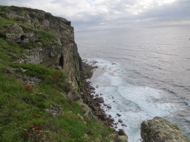
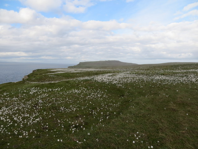
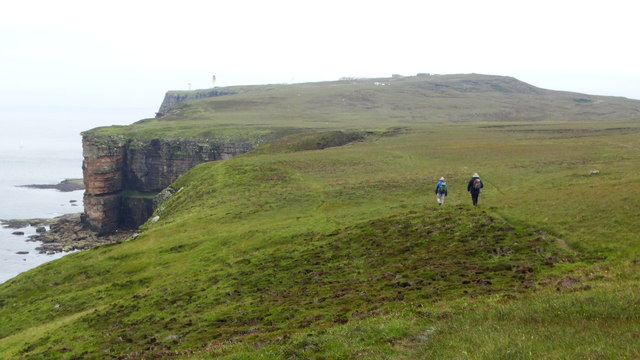
Situated near the small village of Brough, Dunnet Head is characterized by its rugged and dramatic landscape. The hill is predominantly covered in heather and grass, with scattered patches of gorse and wildflowers adding vibrant colors to the terrain. Its rocky cliffs and steep slopes provide a habitat for various bird species, including puffins, guillemots, and razorbills, making it a designated Site of Special Scientific Interest.

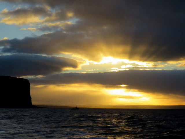
Visitors to Dunnet Head can enjoy a range of activities, such as hiking along the well-maintained trails that wind their way up the hill. The paths offer stunning views of the North Sea, the Orkney Islands, and the nearby Dunnet Bay. On clear days, it is even possible to catch a glimpse of the Old Man of Hoy, a famous sea stack located off the coast of Orkney.

In addition to its natural beauty, Dunnet Head is also home to a lighthouse, which was built in 1831 and still operates today. The lighthouse serves as an important navigational aid for ships passing through the Pentland Firth, one of the most treacherous stretches of water in the British Isles.

Overall, Dunnet Head is a captivating destination that showcases the raw beauty of the northern Scottish landscape while offering a glimpse into the region's rich maritime history.

If you have any feedback on the listing, please let us know in the comments section below.

Dunnet Head Images

Images are sourced within 2km of 58.669163/-3.3723685 or Grid Reference ND2076. Thanks to Geograph Open Source API. All images are credited.

Many Lochs A view of the middle of the three lochs.
Many Lochs
A view of the middle of the three lochs.
Fish Craig, Dunnet Head Looking along from Dunnet Head towards Thurso - shows Spear Head by Scrabster in the distance.
Fish Craig, Dunnet Head
Looking along from Dunnet Head towards Thurso - shows Spear Head by Scrabster in the distance.
Cliff view from Dunnet Head
The Neback, Dunnet Head The Neback is a prominent crag on the Old Red Sandstone cliffs of Dunnet Head.
The Neback, Dunnet Head
The Neback is a prominent crag on the Old Red Sandstone cliffs of Dunnet Head.
The Long Byre, Dunnet Head The Long Byre is a dry ravine, probably created by fracture of the underlying bedrock. It lies on the Dunnet Head Common Grazing and is so named because it was used by the crofters as a natural cattle pen. Seen here from the East.
The Long Byre, Dunnet Head
The Long Byre is a dry ravine, probably created by fracture of the underlying bedrock. It lies on the Dunnet Head Common Grazing and is so named because it was used by the crofters as a natural cattle pen. Seen here from the East.
The Long Byre, Dunnet Head The Long Byre, a naturally-formed cattle pen, seen from the South West.
The Long Byre, Dunnet Head
The Long Byre, a naturally-formed cattle pen, seen from the South West.
Peatbank on Dunnet Head Peats are cut for fuel in April and May so that they can dry during the summer months.
Peatbank on Dunnet Head
Peats are cut for fuel in April and May so that they can dry during the summer months.
Quarry, Burifa Hill A disused quarry on Dunnet Head
Quarry, Burifa Hill
A disused quarry on Dunnet Head
Peat banks on Dunnet Head Old peat banks, now out of use. Peat is still cut elsewhere on Dunnet Head, although the practice has declined.
Peat banks on Dunnet Head
Old peat banks, now out of use. Peat is still cut elsewhere on Dunnet Head, although the practice has declined.
View to the west of Dunnet Head
Sea cliffs near The Neback at Dunnet Head
Cliffs and skerries at Dunnet Head
Bog cotton on the moor above the cliffs at Dunnet Head
Anglers in the dying light off The Neback It's after four in the afternoon on a coldish November day when a hungry, cold, easterly wind has been blowing all day as the sun rapidly falls in the west.
Anglers in the dying light off The Neback
It's after four in the afternoon on a coldish November day when a hungry, cold, easterly wind has been blowing all day as the sun rapidly falls in the west.
And when I said, "more tea vicar..." The skipper talks tactics with one of his clients en route to the fishing grounds.
And when I said, "more tea vicar..."
The skipper talks tactics with one of his clients en route to the fishing grounds.
One that didn't get away - a Porbeagle shark I was privileged enough to land this specimen the other day:this Porbeagle weighed in around the 230 pound mark and will never be forgotten. Found mostly in the colder waters of the North Atlantic, the Porbeagle is listed as a mackerel shark and can reach over 8 feet in length and 500 pounds plus in weight. The species is most streamlined with a stout mid section and long pointed snout. The Porbeagle has the ability to quickly change its body temperature which in turn enables it to adapt to a wide range of water temperatures. In truth this shark did get away as it was released immediately after capture, unharmed and unscathed.
One that didn't get away - a Porbeagle shark
I was privileged enough to land this specimen the other day:this Porbeagle weighed in around the 230 pound mark and will never be forgotten. Found mostly in the colder waters of the North Atlantic, the Porbeagle is listed as a mackerel shark and can reach over 8 feet in length and 500 pounds plus in weight. The species is most streamlined with a stout mid section and long pointed snout. The Porbeagle has the ability to quickly change its body temperature which in turn enables it to adapt to a wide range of water temperatures. In truth this shark did get away as it was released immediately after capture, unharmed and unscathed.
Walking towards Dunnet Head at Long Byre
Water cascading off cliffs at Shira Geo, Dunnet Head After a very wet night water was cascading off the plateau west of Dunnet Head. It made for an exceedingly wet walk underfoot from Dwarwick Pier with many small streams in spate.
Water cascading off cliffs at Shira Geo, Dunnet Head
After a very wet night water was cascading off the plateau west of Dunnet Head. It made for an exceedingly wet walk underfoot from Dwarwick Pier with many small streams in spate.
Show me another place!

Dunnet Head is located at Grid Ref: ND2076 (Lat: 58.669163, Lng: -3.3723685)

Unitary Authority: Highland

Police Authority: Highlands and Islands

What 3 Words

///smiled.ferried.scanty. Near Thurso, Highland

Related Wikis

Dunnet Head Lighthouse

Dunnet Head Lighthouse is an active 19th century lighthouse that stands on the 300-foot (91 m) cliff top of Easter Head on Dunnet Head. The lighthouse...

Dunnet Head

Dunnet Head (Scottish Gaelic: Ceann Dùnaid) is a peninsula in Caithness, on the north coast of Scotland. Dunnet Head includes the most northerly point...

Brough Castle (Caithness)

Brough Castle is a ruined castle near Brough, Caithness. It is believed to date from the 12th to 14th centuries. == Description == The foundations of...

Brough, Caithness

Brough is a small village (population 66) in Caithness in the North of Scotland. It is located on the B855 single-track road, the most northerly numbered...

Nearby Amenities

Located within 500m of 58.669163,-3.3723685
Source: PGS
Lat/Long: 58.6701528/-3.3654155
Source: PGS
Lat/Long: 58.6704134/-3.3661505
Source: PGS
Lat/Long: 58.6702806/-3.3676911
Source: PGS
Lat/Long: 58.6705623/-3.3684014
Source: PGS
Lat/Long: 58.6704301/-3.3704388
Source: PGS
Lat/Long: 58.6705735/-3.3709398
Source: PGS
Lat/Long: 58.6708661/-3.3719408
Source: PGS
Lat/Long: 58.6710587/-3.3722732
Source: PGS
Lat/Long: 58.6711622/-3.3727316
Source: PGS
Lat/Long: 58.6712888/-3.3741516
Source: PGS
Lat/Long: 58.6720484/-3.3761758
Source: PGS
Lat/Long: 58.672049/-3.376602
Easter Head
Natural: cape
Source: PGS
Lat/Long: 58.672078/-3.3770024
Source: PGS
Lat/Long: 58.6714636/-3.3774797
Source: PGS
Lat/Long: 58.6712995/-3.3777625
Source: PGS
Lat/Long: 58.670679/-3.3780151
Source: PGS
Lat/Long: 58.6704629/-3.3782867
Source: PGS
Lat/Long: 58.6702343/-3.3790497
Source: PGS
Lat/Long: 58.6700212/-3.3797568
Source: PGS
Lat/Long: 58.6699079/-3.3804971
Source: PGS
Lat/Long: 58.6699224/-3.3808855
Dunnet Head
Alt Name: Ceann Dùnaid
Name Ga: Ceann Dúnaid
Name Gd: Rubha Dhùnaid
Name Sco: Dinnad Heid
Natural: cape
Place: locality
Wikidata: Q1260729
Wikipedia: en:Dunnet Head
Lat/Long: 58.6688045/-3.374241
Dunnet Head
Description: Most Northerly Point on British Mainland
Tourism: viewpoint
Lat/Long: 58.669025/-3.371794
Barrier: cattle_grid
Lat/Long: 58.6693545/-3.3770887
Dunnet Head
Name En: Dunnet Head
Tourism: attraction
Lat/Long: 58.6708197/-3.3761911
Natural: spring
Lat/Long: 58.6697813/-3.3758363
Power: pole
Lat/Long: 58.6654556/-3.376202
Power: pole
Lat/Long: 58.6662274/-3.3762101
Power: pole
Lat/Long: 58.6669601/-3.3762284
Power: pole
Lat/Long: 58.6676633/-3.3762467
Power: pole
Lat/Long: 58.6683887/-3.3762528
Power: pole
Lat/Long: 58.6687698/-3.3762548
Power: pole
Lat/Long: 58.6691615/-3.376267
Power: pole
Lat/Long: 58.669777/-3.3761939
Power: pole
Lat/Long: 58.6704717/-3.3761309
Power: pole
Lat/Long: 58.6708707/-3.376137
Power: pole
Lat/Long: 58.6703756/-3.3732722
Power: pole
Lat/Long: 58.670403/-3.3740457
Power: pole
Lat/Long: 58.6704273/-3.3748416
The data included in this document is from www.openstreetmap.org. The data is made available under ODbL.

Have you been to Dunnet Head?

Leave your review of Dunnet Head below (or comments, questions and feedback).