Beacon Hill
Hill, Mountain in Radnorshire
Wales
Beacon Hill

Beacon Hill is a prominent hill located in the county of Radnorshire, Wales. Rising to an elevation of approximately 1,902 feet (580 meters), it is considered one of the highest peaks in the region, offering breathtaking panoramic views of the surrounding countryside.
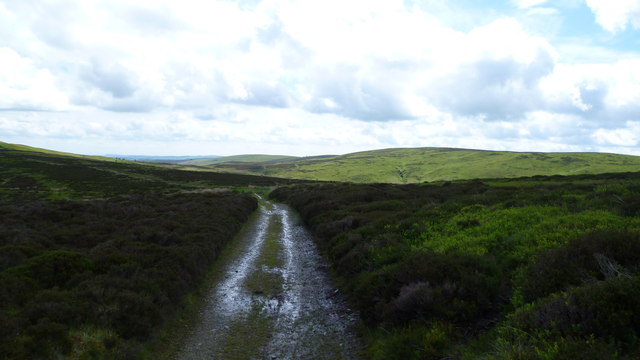
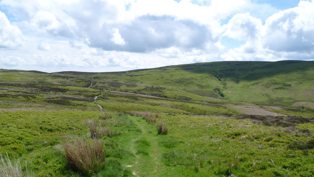
Situated within the Radnor Forest, Beacon Hill is part of the stunning Cambrian Mountains range. Its distinct shape and prominent position make it a notable landmark within the area. The hill is characterized by its rocky terrain, covered in heather, grasses, and scattered patches of woodland, contributing to its natural beauty.
Beacon Hill derives its name from the historical practice of using its summit as a signaling point, where beacons were lit to transmit important messages across the countryside. This practice was particularly prominent during times of war or to warn of imminent danger.
The hill attracts a steady stream of hikers, nature enthusiasts, and photographers who are drawn to its stunning vistas and tranquil surroundings. Various walking trails traverse the hill, offering visitors the opportunity to explore its diverse flora and fauna while enjoying the peaceful ambiance.
In addition to its natural allure, Beacon Hill also holds historical significance. The remains of an Iron Age hillfort can be found on its slopes, providing insights into the area's ancient past. Archaeological excavations have revealed artifacts and structures dating back thousands of years.
Overall, Beacon Hill is a captivating destination for those seeking both natural beauty and a glimpse into the rich history of Radnorshire. Its commanding presence and picturesque landscapes make it a must-visit location for anyone exploring the region.
If you have any feedback on the listing, please let us know in the comments section below.
Beacon Hill Images
Images are sourced within 2km of 52.382944/-3.2114197 or Grid Reference SO1776. Thanks to Geograph Open Source API. All images are credited.


Beacon Hill is located at Grid Ref: SO1776 (Lat: 52.382944, Lng: -3.2114197)
Unitary Authority: Powys
Police Authority: Dyfed Powys
What 3 Words
///trout.mailings.cherub. Near Knighton, Powys
Nearby Locations
Related Wikis
Beacon Hill, Powys
Beacon Hill (Welsh: Mynydd Disglair) is a hill in the county of Radnorshire, Wales. It lies within the Powys unitary council area. It is located north...

Beguildy
Beguildy (Welsh: Bugeildy) is a village and community in Powys, Wales. It lies in a remote tract of countryside, 8 miles (13 km) northwest of Knighton...
East Wales
East Wales (Welsh: Dwyrain Cymru) is either a ITL 3 statistical region of Wales or generally a region encompassing the easternmost parts of the country...
Quabbs
Quabbs is a small, scattered hamlet in the southwest of Shropshire, near the border between England and Wales. The name, which also occurs in Gloucestershire...

Llangynllo railway station
Llangynllo railway station is a countryside stop in Powys about 5 miles west of Knighton, on the Heart of Wales Line. The station is located 1.4 miles...

Llanbister Road railway station
Llanbister Road railway station is a countryside stop about 5 miles (8 km) from the village of Llanbister, Powys, Wales. The station is 41+3⁄4 miles (67...
Bettws-y-Crwyn
Bettws-y-Crwyn (Welsh: Betws-y-crwyn / Betwsycrowyn) is a small, remote village and civil parish in south-west Shropshire, England. It is close to the...
Llanfair Waterdine
Llanfair Waterdine, sometimes written as Llanvair Waterdine and meaning St Mary's Church Waterdine, is a small village and civil parish in Shropshire,...
Have you been to Beacon Hill?
Leave your review of Beacon Hill below (or comments, questions and feedback).