Stirrup Crag

Hill, Mountain in Cumberland Copeland

England

Stirrup Crag

Bridleway in Mosedale This bridleway in Mosedale leads up to the Black Sail Pass.
Bridleway in Mosedale Credit: Philip Halling

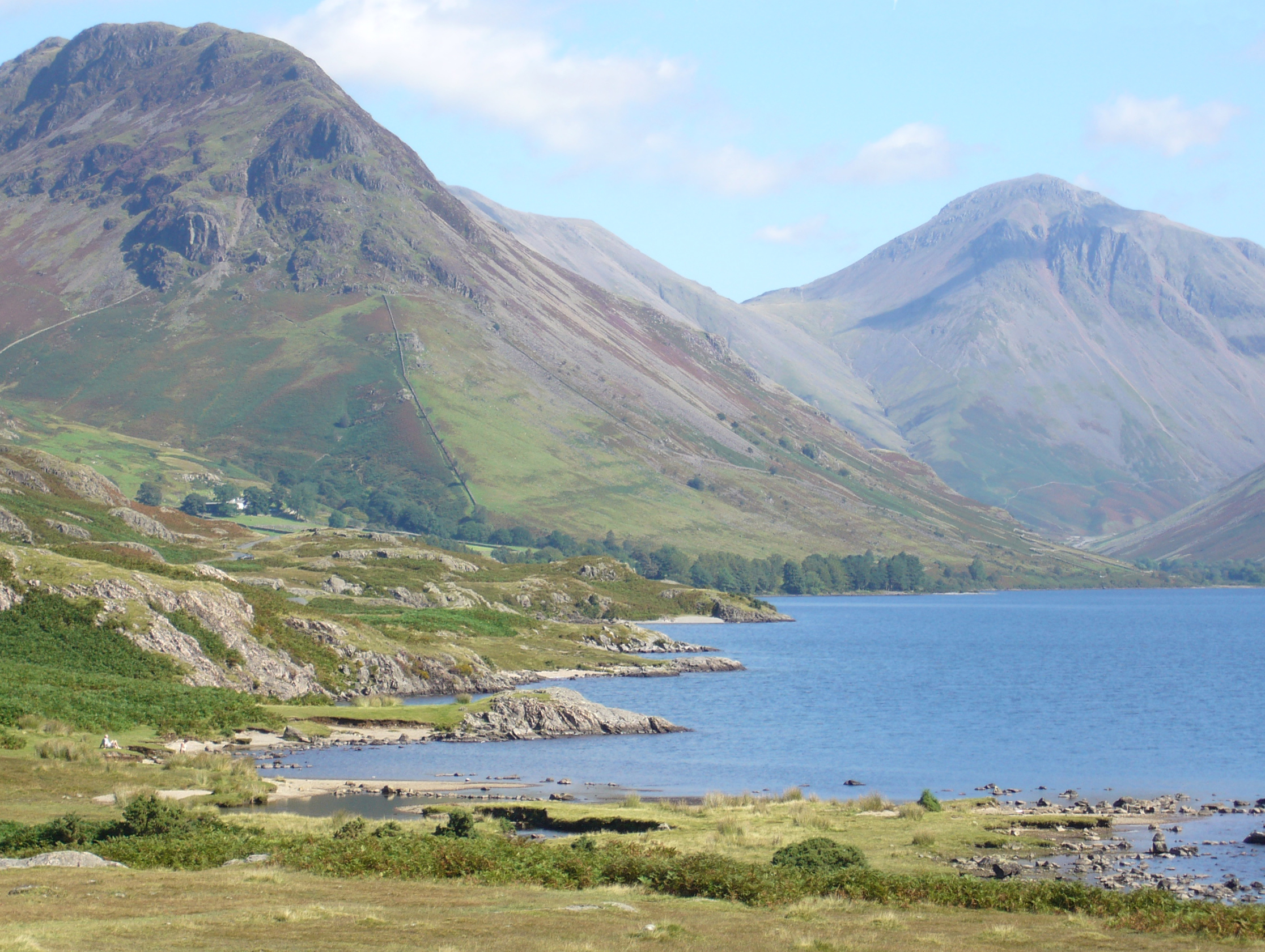
Stirrup Crag, located in the county of Cumberland, is a prominent hill/mountain in the Lake District National Park in northwestern England. Standing at an elevation of approximately 600 meters (1,970 feet), it offers breathtaking panoramic views of the surrounding landscape.

The crag is known for its distinctive horseshoe shape, which gives it its name, resembling a stirrup commonly used in horse riding. This unique feature makes it easily recognizable from various viewpoints in the area. It is situated in close proximity to the picturesque village of Keswick, adding to its popularity among locals and tourists alike.

The ascent to Stirrup Crag can be challenging, with steep slopes and rocky terrain, making it a favorite destination for experienced hikers and mountaineers seeking a more demanding outdoor adventure. However, the efforts are rewarded with awe-inspiring vistas across the Lake District, including the towering peaks of Skiddaw and Blencathra.

The crag is also known for its rich biodiversity, with a variety of plant and animal species calling it home. The slopes are covered in heather, bracken, and grasses, providing a habitat for numerous small mammals and birds. It is not uncommon to spot red squirrels, mountain hares, and various species of birds of prey soaring above.

Stirrup Crag offers a perfect blend of natural beauty, challenging hikes, and stunning views, making it a must-visit destination for outdoor enthusiasts and nature lovers exploring the Lake District.

If you have any feedback on the listing, please let us know in the comments section below.

Stirrup Crag Images

Images are sourced within 2km of 54.471382/-3.2734101 or Grid Reference NY1709. Thanks to Geograph Open Source API. All images are credited.

Bridleway in Mosedale This bridleway in Mosedale leads up to the Black Sail Pass.
Bridleway in Mosedale
This bridleway in Mosedale leads up to the Black Sail Pass.
Gatherstone Beck Mountain stream above Mosedale with Looking Stead, part of Pillar in the background.
Gatherstone Beck
Mountain stream above Mosedale with Looking Stead, part of Pillar in the background.
Gatherstone Beck Mountain stream, a mountain stream above Mosedale viewed from the bridleway leading to Black Sail Pass.
Gatherstone Beck
Mountain stream, a mountain stream above Mosedale viewed from the bridleway leading to Black Sail Pass.
Bridleway crossing Gatherstone Beck Bridleway crossing Gatherstone Beck in Mosedale.
Bridleway crossing Gatherstone Beck
Bridleway crossing Gatherstone Beck in Mosedale.
Path heading up the Mosedale valley Path from Wasdale Head heading up the Mosedale valley
Path heading up the Mosedale valley
Path from Wasdale Head heading up the Mosedale valley
Mosedale Valley Looking up the Mosedale Valley with a  Herdwick Sheep stood on a boulder with the final path to Wind Gap visible in the distance
Mosedale Valley
Looking up the Mosedale Valley with a Herdwick Sheep stood on a boulder with the final path to Wind Gap visible in the distance
Wasdale Head These former farm buildings are now used to serve tourists with a shop and holiday apartments.
The steep fell in the background is the northern shoulder of Yewbarrow.
There is an Ordnance Survey cut benchmark on the pillar between the doors beyond the yellow defibrillator box (photograph <a href="https://www.geograph.org.uk/photo/7123697">NY1808 : Benchmark, Wasdale Head</a>).
Wasdale Head
These former farm buildings are now used to serve tourists with a shop and holiday apartments. The steep fell in the background is the northern shoulder of Yewbarrow. There is an Ordnance Survey cut benchmark on the pillar between the doors beyond the yellow defibrillator box (photograph NY1808 : Benchmark, Wasdale Head).
Benchmark, Wasdale Head Detail of the Ordnance Survey cut benchmark on a former barn (now a shop and holiday accommodation) at Wasdale Head. In spite of the many years since the benchmark was cut, the darkness of the cut stone still contrasts with the weathered surface of the natural block used in the construction of the barn.
The benchmark marks a height of 80.3483m above sea level (Ordnance Datum Newlyn) last verified in 1956 (location photograph <a href="https://www.geograph.org.uk/photo/7123690">NY1808 : Wasdale Head</a>).
Benchmark, Wasdale Head
Detail of the Ordnance Survey cut benchmark on a former barn (now a shop and holiday accommodation) at Wasdale Head. In spite of the many years since the benchmark was cut, the darkness of the cut stone still contrasts with the weathered surface of the natural block used in the construction of the barn. The benchmark marks a height of 80.3483m above sea level (Ordnance Datum Newlyn) last verified in 1956 (location photograph NY1808 : Wasdale Head).
Moody day at Wasdale Head The morning’s low cloud and rain had cleared and as a foretaste of better weather to come a brief glimpse of sun catches Great Gable between Great Napes and Tom Blue.
Moody day at Wasdale Head
The morning’s low cloud and rain had cleared and as a foretaste of better weather to come a brief glimpse of sun catches Great Gable between Great Napes and Tom Blue.
Wastwater and Wasdale Head Some of the most remote Lakeland country - taken from the path that follows Wastwater through some really brutal scree slopes.
Wastwater and Wasdale Head
Some of the most remote Lakeland country - taken from the path that follows Wastwater through some really brutal scree slopes.
Queen Victoria (VR) Post Box (1837-1901), Wasdale Head
Packhorse Bridge Over Mosdale Beck, Wasdale Head
Ritson Force Waterfall (Upper Section), Wasdale Head The waterfall is said to be named after Will Ritson, landlord and tall tale teller at the nearby Wasdale Head Inn.
Ritson Force Waterfall (Upper Section), Wasdale Head
The waterfall is said to be named after Will Ritson, landlord and tall tale teller at the nearby Wasdale Head Inn.
Ritson Force Waterfall (Lower Section), Wasdale Head The waterfall is said to be named after Will Ritson, landlord and tall tale teller at the nearby Wasdale Head Inn.
Ritson Force Waterfall (Lower Section), Wasdale Head
The waterfall is said to be named after Will Ritson, landlord and tall tale teller at the nearby Wasdale Head Inn.
Moses Trod (Path), Wasdale Head
St. Olaf's Church, Wasdale Head St Olaf's Church in Wasdale Head, Cumbria, is England's smallest parish church. The earliest record of the church is from 1550, though it probably predates this, and it is likely that there was an earlier church on this site. The church was dedicated to St Olaf in 1977, before which it had no name.

<span class="nowrap"><a title="https://en.wikipedia.org/wiki/St_Olaf%27s_Church,_Wasdale" rel="nofollow ugc noopener" href="https://en.wikipedia.org/wiki/St_Olaf%27s_Church,_Wasdale">Link</a><img style="margin-left:2px;" alt="External link" title="External link - shift click to open in new window" src="https://s1.geograph.org.uk/img/external.png" width="10" height="10"/></span>
St. Olaf's Church, Wasdale Head
St Olaf's Church in Wasdale Head, Cumbria, is England's smallest parish church. The earliest record of the church is from 1550, though it probably predates this, and it is likely that there was an earlier church on this site. The church was dedicated to St Olaf in 1977, before which it had no name. LinkExternal link
Wast Water c.1970
Wast Water c.1970
Valley of Mosedale Beck Mosedale is one of the two main side valleys branching from Wasdale at Wasdale Head; Mosedale apparently means dreary valley!
The mountain at the centre of the image is Pillar.
Valley of Mosedale Beck
Mosedale is one of the two main side valleys branching from Wasdale at Wasdale Head; Mosedale apparently means dreary valley! The mountain at the centre of the image is Pillar.
Show me another place!

Stirrup Crag is located at Grid Ref: NY1709 (Lat: 54.471382, Lng: -3.2734101)

Administrative County: Cumbria

District: Copeland

Police Authority: Cumbria

What 3 Words

///woven.heaven.gloom. Near Seascale, Cumbria

Nearby Locations

Stirrup Crag

Related Wikis

Yewbarrow

Yewbarrow is a fell, in the English Lake District, which lies immediately north of the head of Wast Water. It is 628 metres (2,060 feet) high and in shape...

St Olaf's Church, Wasdale

St Olaf's Church in Wasdale Head, Cumbria, is England's smallest parish church. The earliest record of a church on this site is from 1550, though it is...

Wasdale Head

Wasdale Head (; traditionally ) is a scattered agricultural hamlet in the Lake District National Park in Cumbria, England. Wasdale Head claims to be home...

Mosedale Beck (Wast Water)

Mosedale Beck is a stream in Cumbria which runs into Wast Water, which is the deepest lake in England. Mosedale Beck rises in Little Scoat Fell, it then...

Nearby Amenities

Located within 500m of 54.471382,-3.2734101
Dore Head
Place: locality
Lat/Long: 54.4750389/-3.2773221
Ford: yes
Lat/Long: 54.471931/-3.2787732
The data included in this document is from www.openstreetmap.org. The data is made available under ODbL.

Have you been to Stirrup Crag?

Leave your review of Stirrup Crag below (or comments, questions and feedback).