Fifescar Knowe

Hill, Mountain in Peeblesshire

Scotland

Fifescar Knowe

Fence and moorland on Notman Law Grassy moorland on the left of the fence and heather moorland with the Thief's Road on the right.
Fence and moorland on Notman Law Credit: wrobison

Fifescar Knowe is a notable hill located in the region of Peeblesshire, Scotland. Standing at an elevation of approximately 450 meters (1,480 feet), it offers panoramic views of the surrounding countryside. The hill is situated in the Southern Uplands, an area known for its rugged beauty and diverse wildlife.

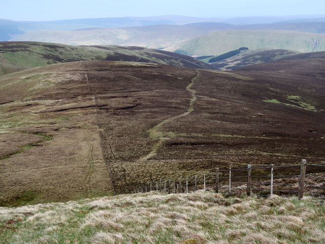
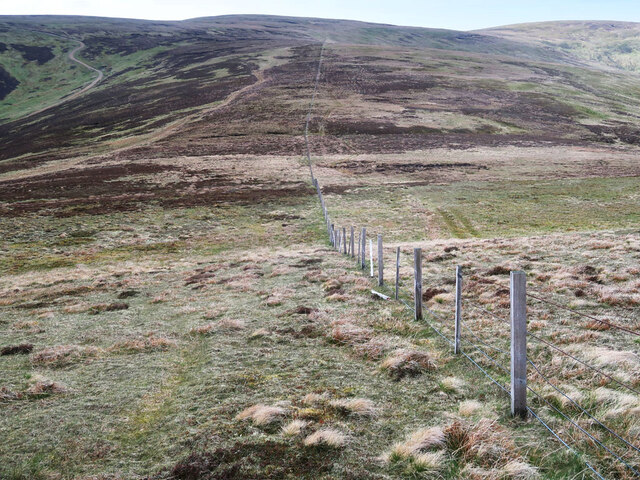
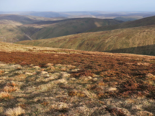
Fifescar Knowe is characterized by its distinctive shape, featuring a gently sloping eastern side and a steeper western face. The hill is primarily composed of sedimentary rocks, including sandstone and shale, which have been shaped by erosion over millions of years. This geological history is evident in the exposed rock formations that can be observed along the hillside.

The vegetation on Fifescar Knowe is predominantly heather and grasses, with scattered tree cover in certain areas. This provides habitat for a variety of wildlife, including red grouse, rabbits, and the occasional deer. Birdwatchers can also spot various species of birds, such as skylarks and meadow pipits, soaring above the hill.

The hill is a popular destination for outdoor enthusiasts, offering several walking trails and paths that lead to its summit. Hikers can enjoy a challenging yet rewarding climb, with breathtaking views awaiting them at the top. Additionally, the surrounding area provides opportunities for other activities such as birdwatching, photography, and nature exploration.

Overall, Fifescar Knowe stands as a prominent feature in the Peeblesshire landscape, drawing visitors with its natural beauty, diverse wildlife, and stunning vistas.

If you have any feedback on the listing, please let us know in the comments section below.

Fifescar Knowe Images

Images are sourced within 2km of 55.5305/-3.3081921 or Grid Reference NT1727. Thanks to Geograph Open Source API. All images are credited.

Fence and moorland on Notman Law Grassy moorland on the left of the fence and heather moorland with the Thief's Road on the right.
Fence and moorland on Notman Law
Grassy moorland on the left of the fence and heather moorland with the Thief's Road on the right.
Fence and moorland on Notman Law Looking towards Fifescar Knowe.
Fence and moorland on Notman Law
Looking towards Fifescar Knowe.
The Thief's Road on Fifescar Knowe Looking towards Notman Law.
The Thief's Road on Fifescar Knowe
Looking towards Notman Law.
Fence and old dyke on Dollar Law Looking towards Fifescar Knowe with Broad Law on the right.
Fence and old dyke on Dollar Law
Looking towards Fifescar Knowe with Broad Law on the right.
Fence and moorland on Dollar Law Descending to Newholm Cairns Hill.
Fence and moorland on Dollar Law
Descending to Newholm Cairns Hill.
Moorland on Dollar Law East of the summit looking over Ugly Grain to Manor Rig.
Moorland on Dollar Law
East of the summit looking over Ugly Grain to Manor Rig.
Fence and old dyke descending Dollar Law A steep descent off the hill to Manorhead.
Fence and old dyke descending Dollar Law
A steep descent off the hill to Manorhead.
Moorland track on Dun Rig Looking down from Hunt Law.
Moorland track on Dun Rig
Looking down from Hunt Law.
Col between Cramalt Craig and Dun Law Looking towards Dun Law.
Col between Cramalt Craig and Dun Law
Looking towards Dun Law.
Hill track, Cramalt Crook A track up from Cramalt farm by Megget Reservoir, nearing the ridge at Dun Law.
Hill track, Cramalt Crook
A track up from Cramalt farm by Megget Reservoir, nearing the ridge at Dun Law.
Fence to Notman Law summit Looking back to the rounded top from the angle in the fence, where the track from Megget crosses on the way towards Fifescar Knowe.
Fence to Notman Law summit
Looking back to the rounded top from the angle in the fence, where the track from Megget crosses on the way towards Fifescar Knowe.
Aircraft wreckage, Dollar Law Remains of an aircraft crash about 350m east of the summit. There are rusted metal tubes, smaller debris and some aluminium components. 

The website 'Air Crash Sites Scotland' lists the following details: 

Crash date 28 February 1949
Aircraft type De Havilland Dominie, registration X7400, Royal Navy Air Squadron

The pilot survived the crash after the plane lost height due to port engine failure. More details are given at <span class="nowrap"><a title="http://www.aircrashsites-scotland.co.uk/dh-dominie-dollar-law.htm" rel="nofollow ugc noopener" href="http://www.aircrashsites-scotland.co.uk/dh-dominie-dollar-law.htm">Link</a><img style="margin-left:2px;" alt="External link" title="External link - shift click to open in new window" src="https://s1.geograph.org.uk/img/external.png" width="10" height="10"/></span>

Some further information from 'A Source of Manor' published locally by Lyne and Manor Youth Group, 1999: "The pilot crash landed and survived. He got out of the plane and walked down to Manorhead where he took the pony and trap to Posso to use the telephone, as it was one of the few in the valley at the time."
Aircraft wreckage, Dollar Law
Remains of an aircraft crash about 350m east of the summit. There are rusted metal tubes, smaller debris and some aluminium components. The website 'Air Crash Sites Scotland' lists the following details: Crash date 28 February 1949 Aircraft type De Havilland Dominie, registration X7400, Royal Navy Air Squadron The pilot survived the crash after the plane lost height due to port engine failure. More details are given at LinkExternal link Some further information from 'A Source of Manor' published locally by Lyne and Manor Youth Group, 1999: "The pilot crash landed and survived. He got out of the plane and walked down to Manorhead where he took the pony and trap to Posso to use the telephone, as it was one of the few in the valley at the time."
Head of Ugly Grain, Dollar Law The headstreams of Ugly Grain, the burn on which Manorhead farm lies.
Head of Ugly Grain, Dollar Law
The headstreams of Ugly Grain, the burn on which Manorhead farm lies.
Fence junction, Dollar Law The fence on the left comes up from Kirk Hope and the ridge in the middle distance is Kirkhope Rig, with the lower reaches of the Manor Valley beyond.
Fence junction, Dollar Law
The fence on the left comes up from Kirk Hope and the ridge in the middle distance is Kirkhope Rig, with the lower reaches of the Manor Valley beyond.
Down the east side of Dollar Law Still about 400m of height to lose before the valley road is reached, but easier than making the ascent this way.
Down the east side of Dollar Law
Still about 400m of height to lose before the valley road is reached, but easier than making the ascent this way.
Moorland, Fifescar Knowe Stubborn clag on the Dollar Law ridge.  Nowhere near a whiteout, visibility never dropped below 100m.
Moorland, Fifescar Knowe
Stubborn clag on the Dollar Law ridge. Nowhere near a whiteout, visibility never dropped below 100m.
Dyke and fence, Dollar Law A ruined dyke is backed up with a fence. The two continue upwards to the summit of Dollar Law and continue on over Fifescar Knowe.
Dyke and fence, Dollar Law
A ruined dyke is backed up with a fence. The two continue upwards to the summit of Dollar Law and continue on over Fifescar Knowe.
Fence and dyke, Dollar Law Snow is piled high against a ruined dyke near the summit of Dollar Law.  It is worth getting a 1:25,000 map here as the fences are a great help in navigation.  The Harvey map is currently out of print, but a new edition was used in 2015 for the Original Mountain Marathon, so may hit the shops soon.

The fence and dyke continues southwards over the summit of Dollar Law or in descent, down to the tip of the plantation near the public road end in the Manor Valley.  A good way down if in a hurry.
Fence and dyke, Dollar Law
Snow is piled high against a ruined dyke near the summit of Dollar Law. It is worth getting a 1:25,000 map here as the fences are a great help in navigation. The Harvey map is currently out of print, but a new edition was used in 2015 for the Original Mountain Marathon, so may hit the shops soon. The fence and dyke continues southwards over the summit of Dollar Law or in descent, down to the tip of the plantation near the public road end in the Manor Valley. A good way down if in a hurry.
Show me another place!

Fifescar Knowe is located at Grid Ref: NT1727 (Lat: 55.5305, Lng: -3.3081921)

Unitary Authority: The Scottish Borders

Police Authority: The Lothians and Scottish Borders

What 3 Words

///employer.transmit.shuttling. Near Peebles, Scottish Borders

Nearby Locations

Dollar Law Fifescar Knowe

Related Wikis

Black Law (hill)

Black Law is a hill in the Manor Hills range, part of the Southern Uplands of Scotland. One of the more remote Donalds, it does not easily combine into...

Broad Law

Broad Law is a hill in the Manor Hills range, part of the Southern Uplands of Scotland. The second-highest point in the Southern Uplands and the highest...

Craigierig

Craigierig is a village on the Megget Reservoir, in the Scottish Borders area of Scotland, in the former Selkirkshire. Places nearby include the Glengaber...

Megget

Megget is a former chapelry or parish containing the valley of Megget Water, now forming the westernmost part of the parish of Yarrow, Selkirkshire in...

Have you been to Fifescar Knowe?

Leave your review of Fifescar Knowe below (or comments, questions and feedback).