Greig Hill

Hill, Mountain in Kinross-shire

Scotland

Greig Hill

Loch Leven A shower passing to the north, time to get off the water.
Loch Leven Credit: Richard Webb

Greig Hill is a prominent natural feature located in Kinross-shire, Scotland. Standing at an elevation of approximately 180 meters (590 feet), it is classified as a hill rather than a mountain due to its moderate height. The hill is situated in the rolling landscape of central Scotland, offering picturesque views of the surrounding countryside.

Greig Hill is predominantly covered with heather and grass, creating a vibrant green landscape, particularly during the summer months. The hill's slopes are gentle, making it accessible to hikers and nature enthusiasts of all skill levels. A well-defined path leads to the summit, making it an enjoyable and relatively easy ascent.

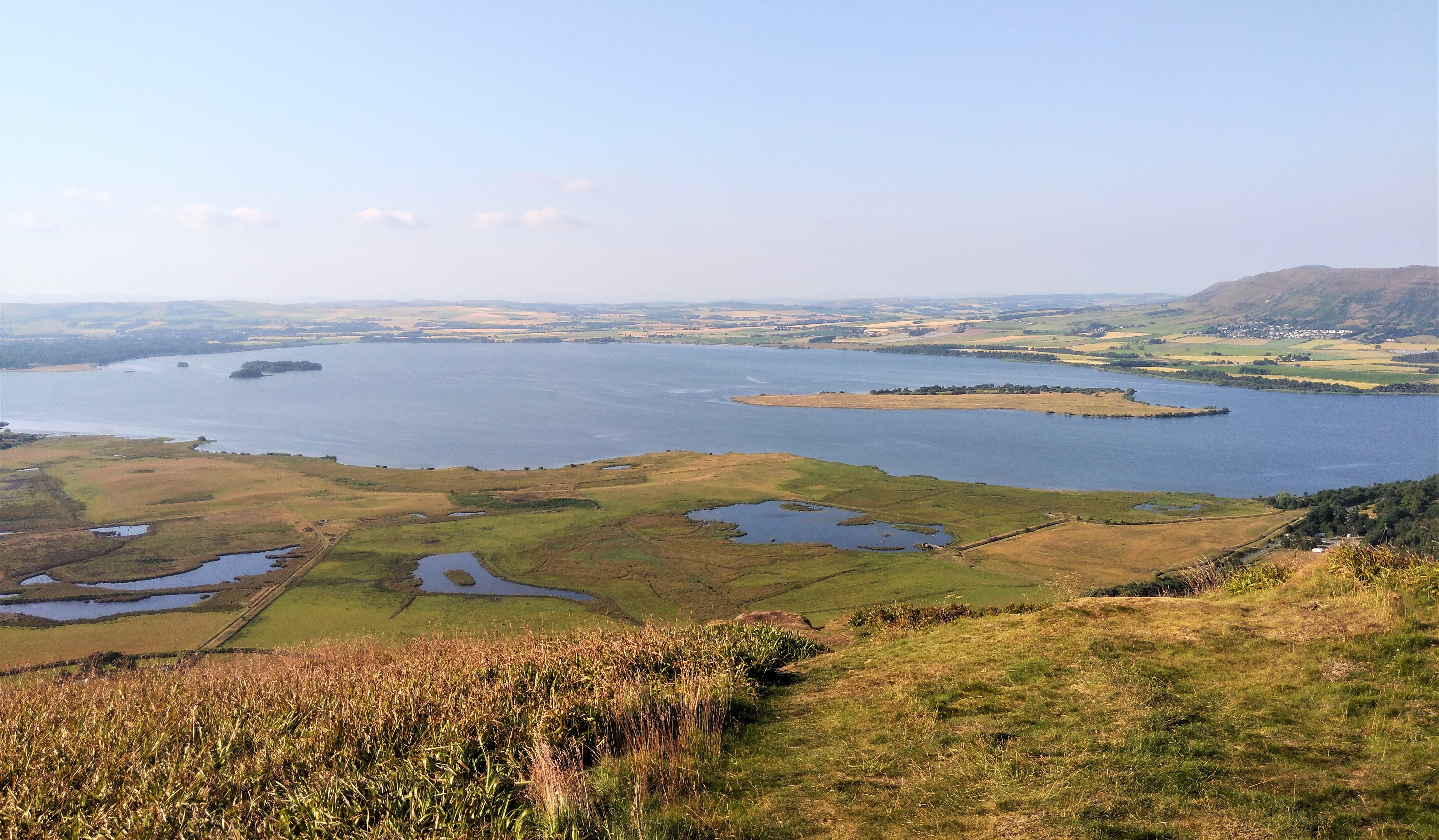
At the top of Greig Hill, visitors are rewarded with breathtaking panoramic vistas that stretch across the region. On clear days, it is possible to see as far as the Ochil Hills to the south and the southern Highlands to the north. The summit also offers a fantastic vantage point for observing local wildlife, including various species of birds, deer, and small mammals.

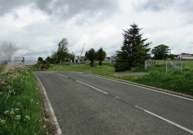
Greig Hill is a popular destination for outdoor activities such as walking, hiking, and picnicking. It provides a peaceful and tranquil setting for visitors to escape the hustle and bustle of daily life. The hill is easily accessible by foot from the nearby village of Kinross, and there are parking facilities available for those who prefer to drive.

Overall, Greig Hill is a natural gem in Kinross-shire, offering stunning views, diverse flora and fauna, and a serene atmosphere, making it a beloved destination for nature lovers and outdoor enthusiasts alike.

If you have any feedback on the listing, please let us know in the comments section below.

Greig Hill Images

Images are sourced within 2km of 56.218458/-3.3694812 or Grid Reference NO1503. Thanks to Geograph Open Source API. All images are credited.

Loch Leven A shower passing to the north, time to get off the water.
Loch Leven
A shower passing to the north, time to get off the water.
Loch Leven shoreline Shoreline of Loch Leven on its north-western corner near Tarhill.
Loch Leven shoreline
Shoreline of Loch Leven on its north-western corner near Tarhill.
Loch Leven Heritage Trail Loch Leven Heritage Trail heading westwards near Orwell.
Loch Leven Heritage Trail
Loch Leven Heritage Trail heading westwards near Orwell.
Scrubland near Loch Leven Looking south-west over scrubland on the north-eastern side of Loch Leven.
Scrubland near Loch Leven
Looking south-west over scrubland on the north-eastern side of Loch Leven.
Loch Leven Heritage Trail Milestone (Burleigh Sands) Milestone (in km), on the Loch Leven Trail at Burleigh Sands on the north-western corner of the loch.
Loch Leven Heritage Trail Milestone (Burleigh Sands)
Milestone (in km), on the Loch Leven Trail at Burleigh Sands on the north-western corner of the loch.
Loch Leven Heritage Trail Milestone (Orwell) Milestone (in km), near Orwell, on the Loch Leven Trail towards the north side of the loch.
Loch Leven Heritage Trail Milestone (Orwell)
Milestone (in km), near Orwell, on the Loch Leven Trail towards the north side of the loch.
Loch Leven Heritage Trail Milestone (Carsehall) Milestone (in km), on the Loch Leven Trail near Carsehall towards the north-eastern side of the loch.
Loch Leven Heritage Trail Milestone (Carsehall)
Milestone (in km), on the Loch Leven Trail near Carsehall towards the north-eastern side of the loch.
Loch Leven Heritage Trail Milestone (Blackwood) Milestone (in km), on the Loch Leven Trail near Blackwood on the eastern side of the loch.
Loch Leven Heritage Trail Milestone (Blackwood)
Milestone (in km), on the Loch Leven Trail near Blackwood on the eastern side of the loch.
Loch Leven in fog Taken from a spot a bit south of Burleigh sands. The contours of Benarty Hill across the loch are barely visible.
Loch Leven in fog
Taken from a spot a bit south of Burleigh sands. The contours of Benarty Hill across the loch are barely visible.
Dusk, Loch Leven A view over Loch Leven, taken at dusk on a November afternoon.
Dusk, Loch Leven
A view over Loch Leven, taken at dusk on a November afternoon.
Field entrance Located close to Channel Farm, with Loch Leven in the distance.
Field entrance
Located close to Channel Farm, with Loch Leven in the distance.
The Pow Mill Standing alongside the A911, the former mill has been restored and converted for residential use. Distant view: <a href="https://www.geograph.org.uk/photo/290570">NO1503 : Pow Burn and Pow Mill</a>.
The Pow Mill
Standing alongside the A911, the former mill has been restored and converted for residential use. Distant view: NO1503 : Pow Burn and Pow Mill.
Loch Leven From the path to Bishop Hill, Castle Island, where Mary Queen of Scots was held captive in Loch Leven Castle for a time, can be seen on the loch.
Loch Leven
From the path to Bishop Hill, Castle Island, where Mary Queen of Scots was held captive in Loch Leven Castle for a time, can be seen on the loch.
Balgedie farmland from Lomond Hills Looking down on the small settlements of Wester Balgedie and Easter Balgedie from the Lomond Hills escarpment, as a rain shower approaches Loch Leven.
Balgedie farmland from Lomond Hills
Looking down on the small settlements of Wester Balgedie and Easter Balgedie from the Lomond Hills escarpment, as a rain shower approaches Loch Leven.
Turning into Dryside Road, Lomond Hills On the A911 close to its junction with the B919 is the turning into Dryside Road which leads to the starting points for two routes into the Lomond Hills Regional Park - the path to Glenvale and the path to the Bunnet Stane and West Lomond. The road sign points to Glenlomond and Wester Balgedie.
Dryside Road runs from this position to the village of Strathmiglo and can also be accessed from there.
See Lomond Hills Regional Park article <a title="https://www.geograph.org.uk/article/Lomond-Hills-Regional-Park" href="https://www.geograph.org.uk/article/Lomond-Hills-Regional-Park">Link</a>
Turning into Dryside Road, Lomond Hills
On the A911 close to its junction with the B919 is the turning into Dryside Road which leads to the starting points for two routes into the Lomond Hills Regional Park - the path to Glenvale and the path to the Bunnet Stane and West Lomond. The road sign points to Glenlomond and Wester Balgedie. Dryside Road runs from this position to the village of Strathmiglo and can also be accessed from there. See Lomond Hills Regional Park article Link
Wester Balgedie, Lomond Hills Dryside Road <a href="https://www.geograph.org.uk/photo/5399912">NO1604 : Turning into Dryside Road, Lomond Hills</a> passes through the small village of Wester Balgedie.
See Lomond Hills Regional Park article <a title="https://www.geograph.org.uk/article/Lomond-Hills-Regional-Park" href="https://www.geograph.org.uk/article/Lomond-Hills-Regional-Park">Link</a>
Wester Balgedie, Lomond Hills
Dryside Road NO1604 : Turning into Dryside Road, Lomond Hills passes through the small village of Wester Balgedie. See Lomond Hills Regional Park article Link
Dryside road, Lomond Hills After leaving Wester Balgedie the road which leads to both the Glenvale path and the path to the Bunnet Stane and West Lomond <a href="https://www.geograph.org.uk/photo/5399912">NO1604 : Turning into Dryside Road, Lomond Hills</a> continues. The hill in the distance is West Lomond.
See Lomond Hills Regional Park article <a title="https://www.geograph.org.uk/article/Lomond-Hills-Regional-Park" href="https://www.geograph.org.uk/article/Lomond-Hills-Regional-Park">Link</a>
Dryside road, Lomond Hills
After leaving Wester Balgedie the road which leads to both the Glenvale path and the path to the Bunnet Stane and West Lomond NO1604 : Turning into Dryside Road, Lomond Hills continues. The hill in the distance is West Lomond. See Lomond Hills Regional Park article Link
Road sign on Dryside Road, Lomond Hills This road sign reminds drivers that this road is well used by both walkers and cyclists.
See Lomond Hills Regional Park article <a title="https://www.geograph.org.uk/article/Lomond-Hills-Regional-Park" href="https://www.geograph.org.uk/article/Lomond-Hills-Regional-Park">Link</a>
Road sign on Dryside Road, Lomond Hills
This road sign reminds drivers that this road is well used by both walkers and cyclists. See Lomond Hills Regional Park article Link
Show me another place!

Greig Hill is located at Grid Ref: NO1503 (Lat: 56.218458, Lng: -3.3694812)

Unitary Authority: Perth and Kinross

Police Authority: Tayside

What 3 Words

///activism.waggled.plank. Near Milnathort, Perth & Kinross

Nearby Locations

Greig Hill

Related Wikis

Carsehall

Carsehall is a village in Perth and Kinross, Scotland. It is northeast of Loch Leven and west of Bishop Hill in the Lomond Hills. It is on the A911 road...

Glenlomond

Glenlomond is a village in Perth and Kinross, Scotland. It lies northeast of Loch Leven, north of the A911 road, at the foot of Bishop Hill in the Lomond...

Loch Leven (Kinross)

Loch Leven (Scottish Gaelic: Loch Lìobhann) is a fresh water loch located immediately to the east of the burgh of Kinross in Perth and Kinross council...

Mawcarse railway station

Mawcarse railway station served the hamlet of Mawcarse, Perth and Kinross, Scotland from 1858 to 1964 on the Fife and Kinross Railway. == History == The...

Nearby Amenities

Located within 500m of 56.218458,-3.3694812
Power: pole
Lat/Long: 56.2226076/-3.3720007
Bench
Backrest: yes
Material: wood
Lat/Long: 56.2185641/-3.371642
The data included in this document is from www.openstreetmap.org. The data is made available under ODbL.

Have you been to Greig Hill?

Leave your review of Greig Hill below (or comments, questions and feedback).