Cnap Allt an Laoigh
Hill, Mountain in Banffshire
Scotland
Cnap Allt an Laoigh

Cnap Allt an Laoigh is a prominent hill located in Banffshire, a historic county in the northeast of Scotland. Standing at an elevation of approximately 1,550 feet (472 meters), it is considered a significant landmark in the region.
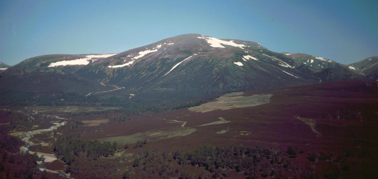
The hill is situated in a remote and picturesque area, surrounded by stunning natural beauty. It is characterized by its rugged terrain, with steep slopes and rocky outcrops. The summit offers breathtaking panoramic views of the surrounding countryside, including the nearby Glenlivet Estate and the Cairngorms National Park.
Cnap Allt an Laoigh is a popular destination for outdoor enthusiasts, particularly hikers and hillwalkers. There are various routes to reach the summit, with options suitable for different levels of fitness and experience. The climb can be challenging, but the reward is worth it, as visitors are treated to magnificent vistas and a sense of tranquility in the rugged Scottish wilderness.
The hill is also home to a diverse range of flora and fauna. The surrounding area is known for its rich biodiversity, with heather moorland, grassy slopes, and scattered woodland providing habitats for various species. Wildlife enthusiasts may spot red deer, mountain hares, and a variety of bird species, including golden eagles and ptarmigans.
Overall, Cnap Allt an Laoigh offers a unique and memorable outdoor experience, combining natural beauty, challenging terrain, and abundant wildlife. It is a must-visit destination for those seeking to explore the rugged beauty of Banffshire and immerse themselves in the Scottish Highlands.
If you have any feedback on the listing, please let us know in the comments section below.
Cnap Allt an Laoigh Images
Images are sourced within 2km of 57.147748/-3.4233252 or Grid Reference NJ1307. Thanks to Geograph Open Source API. All images are credited.


Cnap Allt an Laoigh is located at Grid Ref: NJ1307 (Lat: 57.147748, Lng: -3.4233252)
Unitary Authority: Moray
Police Authority: North East
What 3 Words
///overruns.sunroof.coffee. Near Inverey, Aberdeenshire
Nearby Locations
Related Wikis

Ben Avon
Ben Avon (Scottish Gaelic: Beinn Athfhinn, 'mountain of the Avon') is a mountain in the Cairngorms of Scotland. It is a sprawling mountain with a broad...
Beinn a' Bhùird
Beinn a' Bhùird is a Munro in the Cairngorm mountain range of Scotland. In Watson (1975) the author suggests the mountain should be named Beinn Bòrd -...

Delnadamph Lodge
Delnadamph Lodge was located on the Balmoral Estate about 8 miles (13 km) north of the castle. The lodge and its estate lands were bought by Queen Elizabeth...

Bynack More
Bynack More (Scottish Gaelic: A' Bheithneag Mhòr or Beinn Bheithneag) is a Scottish Mountain that is situated in the Cairngorms range, 16 kilometres east...

Culardoch
Culardoch (900 m) is a mountain in the Cairngorms of Scotland, located northeast of Braemar in Aberdeenshire. A smooth and heathery peak southeast of the...
Have you been to Cnap Allt an Laoigh?
Leave your review of Cnap Allt an Laoigh below (or comments, questions and feedback).