Cleuch Hill

Hill, Mountain in Peeblesshire

Scotland

Cleuch Hill

Pair of Horses, Howslack Farm
Pair of Horses, Howslack Farm Credit: Chris Upson

Cleuch Hill is a prominent hill located in Peeblesshire, a historic county in the southern part of Scotland. It is situated approximately 6 kilometers northwest of the town of Peebles, making it easily accessible for hikers and outdoor enthusiasts.

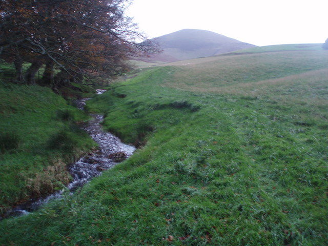
Rising to a height of 450 meters (1476 feet), Cleuch Hill offers stunning panoramic views of the surrounding countryside. Its distinctive shape, characterized by a long ridge and steep slopes, adds to its allure. The hill is covered in heather and grass, creating a picturesque landscape that changes colors with the seasons.

The summit of Cleuch Hill is marked by a trig point, which serves as a navigational aid for walkers and provides a sense of achievement for those who reach its peak. On clear days, the views from the top extend across the rolling hills and valleys of Peeblesshire, offering glimpses of the nearby Tweed Valley and the Moorfoot Hills to the east.

The hill is a popular destination for walkers and hikers, who can choose from various routes to reach the summit. These routes vary in difficulty, catering to both experienced hillwalkers and beginners. Cleuch Hill also attracts mountain bikers, as there are tracks and trails that wind their way through the surrounding countryside.

Overall, Cleuch Hill is a beautiful and accessible hill that offers breathtaking views and outdoor recreational opportunities for visitors of all abilities. Its proximity to Peebles makes it a convenient and enjoyable destination for nature lovers and those seeking an escape to the Scottish countryside.

If you have any feedback on the listing, please let us know in the comments section below.

Cleuch Hill Images

Images are sourced within 2km of 55.603837/-3.4691577 or Grid Reference NT0735. Thanks to Geograph Open Source API. All images are credited.

Pair of Horses, Howslack Farm
Copse of Pine Trees, looking towards Goseland Hill
Bend in the road to Broughton Minor road from Biggar to Broughton
Bend in the road to Broughton
Minor road from Biggar to Broughton
On the straight and narrow road to Biggar Tinto is the hill in the distance
On the straight and narrow road to Biggar
Tinto is the hill in the distance
Sunlit track to Mitchell Hill
Kilbucho Lodge House
Kilbucho Burn Looking NE towards Broughton hills
Kilbucho Burn
Looking NE towards Broughton hills
Road near Gosland Looking towards Knowehead Hill
Road near Gosland
Looking towards Knowehead Hill
The Summit of Goseland Hill View south towards a cloud capped Culter Fell from Goseland Hill (435m). This hill sits on the main watershed of Scotland with the Tweed a short distance to the east and the Clyde a short distance to the west.
The Summit of Goseland Hill
View south towards a cloud capped Culter Fell from Goseland Hill (435m). This hill sits on the main watershed of Scotland with the Tweed a short distance to the east and the Clyde a short distance to the west.
Peeblesshire farmland Photo taken between Biggar and Broughton, where the fields slope down gently from the north and south to Biggar Water.
Peeblesshire farmland
Photo taken between Biggar and Broughton, where the fields slope down gently from the north and south to Biggar Water.
Eyes front! A line-up of curious cattle, Cleuch Farm.
Eyes front!
A line-up of curious cattle, Cleuch Farm.
Farmland near Biggar Landscape typical of this agricultural area.
Farmland near Biggar
Landscape typical of this agricultural area.
Cardon Hill View Cardon Hill seems to dominate the skyline round these parts, despite being basically a shoulder of Chapelgill.
Cardon Hill View
Cardon Hill seems to dominate the skyline round these parts, despite being basically a shoulder of Chapelgill.
The road to South Mains Farm Off the B7016 road from Biggar to Broughton
The road to South Mains Farm
Off the B7016 road from Biggar to Broughton
Hill track near Kilbucho Taken from a junction of two roads - I hope and trust that the industrial sign refers to another road up to a new timber house on the right, not the road shown which runs into some fine hill country in the Coulter Fells.
Hill track near Kilbucho
Taken from a junction of two roads - I hope and trust that the industrial sign refers to another road up to a new timber house on the right, not the road shown which runs into some fine hill country in the Coulter Fells.
Goseland Hill above Kilbucho A heathery isolated hill above parkland.
Goseland Hill above Kilbucho
A heathery isolated hill above parkland.
Kirklaw Hill Stubble field below Kirklaw Hill.
Kirklaw Hill
Stubble field below Kirklaw Hill.
Sheep troughs above the Biggar Water Goseland Hill in the background.
Sheep troughs above the Biggar Water
Goseland Hill in the background.
Show me another place!

Cleuch Hill is located at Grid Ref: NT0735 (Lat: 55.603837, Lng: -3.4691577)

Unitary Authority: The Scottish Borders

Police Authority: The Lothians and Scottish Borders

What 3 Words

///blankets.plankton.stint. Near Biggar, South Lanarkshire

Nearby Locations

Goseland Hill Cleuch Hill

Related Wikis

Kilbucho

Kilbucho (Scottish Gaelic: Cille Bheagha) is a small settlement in the parish of Broughton, Glenholm and Kilbucho in the Scottish Borders area of Scotland...

Skirling

Skirling is a parish, community council area and village in Peeblesshire in the Scottish Borders situated 2+1⁄2 miles east of Biggar in Lanarkshire. Biggar...

Biggar, South Lanarkshire

Biggar (Scottish Gaelic: Bigear [ˈpikʲəɾ]) is a town and former burgh in South Lanarkshire, Scotland, in the Southern Uplands near the River Clyde on...

Broughton railway station (Scotland)

Broughton railway station served the village of Broughton, Scottish Borders, Scotland from 1860 to 1950 on the Symington, Biggar and Broughton Railway...

Have you been to Cleuch Hill?

Leave your review of Cleuch Hill below (or comments, questions and feedback).