Goseland Hill

Hill, Mountain in Peeblesshire

Scotland

Goseland Hill

Pair of Horses, Howslack Farm
Pair of Horses, Howslack Farm Credit: Chris Upson

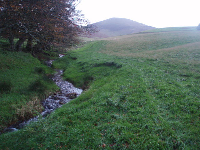
Goseland Hill is a prominent geographical feature located in Peeblesshire, Scotland. Standing at an elevation of approximately 403 meters (1,322 feet), it is classified as a hill rather than a mountain. The hill is situated in the southern part of the county, near the town of Peebles.

Goseland Hill boasts a distinctive conical shape with a rounded summit that offers panoramic views of the surrounding countryside. The hill is primarily composed of sedimentary rocks, including sandstone and shale, which give it a unique geological character.

The vegetation on Goseland Hill is diverse, with heather, grasses, and scattered patches of woodland covering its slopes. This rich flora supports a variety of wildlife, including birds, small mammals, and insects. The hill is known to be especially popular among birdwatchers, who frequently spot species such as buzzards, kestrels, and pheasants.

Goseland Hill is a popular destination for hikers and outdoor enthusiasts, offering a range of walking trails that suit different levels of fitness and experience. The summit can be reached by following well-marked paths, and the ascent is considered moderate, making it accessible to a wide range of visitors.

Overall, Goseland Hill is a picturesque and accessible location, providing visitors with an opportunity to experience the natural beauty and tranquility of the Scottish countryside. Whether for leisurely walks, birdwatching, or simply enjoying the breathtaking views, Goseland Hill offers a memorable experience for all who venture to its heights.

If you have any feedback on the listing, please let us know in the comments section below.

Goseland Hill Images

Images are sourced within 2km of 55.600694/-3.4757699 or Grid Reference NT0735. Thanks to Geograph Open Source API. All images are credited.

Pair of Horses, Howslack Farm
Copse of Pine Trees, looking towards Goseland Hill
Sunlit track to Mitchell Hill
Kilbucho Lodge House
Kilbucho Burn Looking NE towards Broughton hills
Kilbucho Burn
Looking NE towards Broughton hills
Road near Gosland Looking towards Knowehead Hill
Road near Gosland
Looking towards Knowehead Hill
The Summit of Goseland Hill View south towards a cloud capped Culter Fell from Goseland Hill (435m). This hill sits on the main watershed of Scotland with the Tweed a short distance to the east and the Clyde a short distance to the west.
The Summit of Goseland Hill
View south towards a cloud capped Culter Fell from Goseland Hill (435m). This hill sits on the main watershed of Scotland with the Tweed a short distance to the east and the Clyde a short distance to the west.
Eyes front! A line-up of curious cattle, Cleuch Farm.
Eyes front!
A line-up of curious cattle, Cleuch Farm.
Farmland near Biggar Landscape typical of this agricultural area.
Farmland near Biggar
Landscape typical of this agricultural area.
Derelict buildings at Southside Farm Looking East along the valley between Goseland Hill and Mitchell Hill with the currently disused farm buildings in the foreground.
Derelict buildings at Southside Farm
Looking East along the valley between Goseland Hill and Mitchell Hill with the currently disused farm buildings in the foreground.
Kilbucho Church I suspect the cemetery was used long after the church fell into ruin as there are several gravestones from the turn of the 19th century, unless the building has deteriorated rapidly - quite possible at 1000 feet up.
There are worse locations as a last resting place.
Hill in the distance is Cardons Hill.
Kilbucho Church
I suspect the cemetery was used long after the church fell into ruin as there are several gravestones from the turn of the 19th century, unless the building has deteriorated rapidly - quite possible at 1000 feet up. There are worse locations as a last resting place. Hill in the distance is Cardons Hill.
Cardon Hill View Cardon Hill seems to dominate the skyline round these parts, despite being basically a shoulder of Chapelgill.
Cardon Hill View
Cardon Hill seems to dominate the skyline round these parts, despite being basically a shoulder of Chapelgill.
Gorse bush by Hartree Hills, Biggar A splash of colour by the roadside in the spring.
Gorse bush by Hartree Hills, Biggar
A splash of colour by the roadside in the spring.
Hill track near Kilbucho Taken from a junction of two roads - I hope and trust that the industrial sign refers to another road up to a new timber house on the right, not the road shown which runs into some fine hill country in the Coulter Fells.
Hill track near Kilbucho
Taken from a junction of two roads - I hope and trust that the industrial sign refers to another road up to a new timber house on the right, not the road shown which runs into some fine hill country in the Coulter Fells.
Goseland Hill above Kilbucho A heathery isolated hill above parkland.
Goseland Hill above Kilbucho
A heathery isolated hill above parkland.
The road from Coulter to Broughton The hill in the background is Goseland Hill.
The road from Coulter to Broughton
The hill in the background is Goseland Hill.
Ruined church, Kilbucho The old parish church has a long history, certainly back to the 13th century. These ruins probably date from the 18th c; the church was abandoned around 1810. The house just visible in the trees is the manse, built in 1751 and in very good repair still.

More information can be found from the Royal Commission on the Ancient and Historical Monuments of Scotland (RCAHMS) website:  canmore.rcahms.gov.uk
Ruined church, Kilbucho
The old parish church has a long history, certainly back to the 13th century. These ruins probably date from the 18th c; the church was abandoned around 1810. The house just visible in the trees is the manse, built in 1751 and in very good repair still. More information can be found from the Royal Commission on the Ancient and Historical Monuments of Scotland (RCAHMS) website: canmore.rcahms.gov.uk
Old church and cultivation terraces, Kilbucho There are three very well-marked terraces on the N side of the Mitchelhill Burn. The 1:25,000 map shows them continuing a few hundred metres further east.
Old church and cultivation terraces, Kilbucho
There are three very well-marked terraces on the N side of the Mitchelhill Burn. The 1:25,000 map shows them continuing a few hundred metres further east.
Show me another place!

Goseland Hill is located at Grid Ref: NT0735 (Lat: 55.600694, Lng: -3.4757699)

Unitary Authority: The Scottish Borders

Police Authority: The Lothians and Scottish Borders

What 3 Words

///yards.steered.collision. Near Biggar, South Lanarkshire

Nearby Locations

Cleuch Hill Goseland Hill

Related Wikis

Kilbucho

Kilbucho (Scottish Gaelic: Cille Bheagha) is a small settlement in the parish of Broughton, Glenholm and Kilbucho in the Scottish Borders area of Scotland...

Biggar, South Lanarkshire

Biggar (Scottish Gaelic: Bigear [ˈpikʲəɾ]) is a town and former burgh in South Lanarkshire, Scotland, in the Southern Uplands near the River Clyde on...

Boghall Castle

Boghall Castle was a 14th century castle to the south of Biggar, South Lanarkshire, Scotland. Boghall became ruinous in the 19th century. == History... ==

Kello Hospital

Kello Hospital is a health facility in John's Loan, Biggar, South Lanarkshire, Scotland. It is managed by NHS Lanarkshire. == History == The facility,...

Nearby Amenities

Located within 500m of 55.600694,-3.4757699
Goseland Hill
Ele: 435
Ele Ft: 1428
Natural: peak
Lat/Long: 55.6008469/-3.4752859
Power: pole
Lat/Long: 55.5963714/-3.4772882
The data included in this document is from www.openstreetmap.org. The data is made available under ODbL.

Have you been to Goseland Hill?

Leave your review of Goseland Hill below (or comments, questions and feedback).