Ewe Hill

Hill, Mountain in Peeblesshire

Scotland

Ewe Hill

Scottish Borders : The A701 Heading along the A701 through the Scottish Borders.
Scottish Borders : The A701 Credit: Lewis Clarke

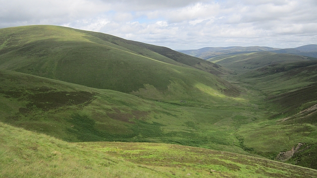
Ewe Hill is a prominent hill located in the county of Peeblesshire, Scotland. It is situated near the town of Peebles and forms part of the rolling hills of the Scottish Borders region. Ewe Hill boasts an elevation of approximately 442 meters (1,450 feet), making it a significant landmark in the area.

The hill is known for its distinctive shape, with a gentle slope on one side and a steeper, craggy face on the other. It is predominantly covered in grass and heather, showcasing the typical vegetation of the Scottish uplands. The summit of Ewe Hill offers breathtaking panoramic views of the surrounding countryside, including nearby hills, valleys, and the River Tweed.

Ewe Hill is a popular destination for outdoor enthusiasts and nature lovers. It provides ample opportunities for walking, hiking, and wildlife observation. The hill is home to a variety of bird species, including red grouse, curlews, and buzzards. Visitors may also spot other wildlife such as hares, rabbits, and deer.

The hill is easily accessible from Peebles, with a network of footpaths and trails leading to its summit. It is a favorite spot for locals and tourists alike, offering a peaceful and picturesque retreat from the hustle and bustle of everyday life.

Overall, Ewe Hill is a beautiful and significant natural feature in Peeblesshire, offering stunning views, diverse wildlife, and outdoor recreational opportunities for all to enjoy.

If you have any feedback on the listing, please let us know in the comments section below.

Ewe Hill Images

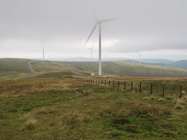
Images are sourced within 2km of 55.487112/-3.4988679 or Grid Reference NT0522. Thanks to Geograph Open Source API. All images are credited.

Scottish Borders : The A701 Heading along the A701 through the Scottish Borders.
Scottish Borders : The A701
Heading along the A701 through the Scottish Borders.
Scottish Borders : The A701 Heading along the A701 through the Scottish Borders.
Scottish Borders : The A701
Heading along the A701 through the Scottish Borders.
Scottish Borders : The A701 Heading along the A701 through the Scottish Borders.
Scottish Borders : The A701
Heading along the A701 through the Scottish Borders.
Scottish Borders : The A701 The A701 and the surrounding hillside.
Scottish Borders : The A701
The A701 and the surrounding hillside.
Scottish Borders : The A701 Looking along the A701 as it heads through the Scottish Borders.
Scottish Borders : The A701
Looking along the A701 as it heads through the Scottish Borders.
Upper Tweeddale Meadowsweet beside the upper Tweed, not far from its source. Much of the land here is forested.
Upper Tweeddale
Meadowsweet beside the upper Tweed, not far from its source. Much of the land here is forested.
River Tweed near to Glenbreck The River Tweed is 97 miles long and flows generally west to east through the Scottish borders. It rises at Tweedsmuir and passes through small towns like Peebles, Selkirk, Melrose, Galashields and Kelso, before entering the North Sea at Berwick on Tweed.
River Tweed near to Glenbreck
The River Tweed is 97 miles long and flows generally west to east through the Scottish borders. It rises at Tweedsmuir and passes through small towns like Peebles, Selkirk, Melrose, Galashields and Kelso, before entering the North Sea at Berwick on Tweed.
A701 south of Glenbreck At one time, the A701 was the major road between Edinburgh and Dumfries. The southern section between Dumfries and Beattock is still a trunk road, forming the primary route link between Dumfries and the A74(M) for northbound Glasgow/Edinburgh traffic. The northern section has now been largely downgraded in favour of the A74M/A702 route to Edinburgh but is popular with some (particularly motorcyclists) as an alternative to the A7 or A702 routes and it is signposted as a scenic route to Edinburgh from the motorway.
A701 south of Glenbreck
At one time, the A701 was the major road between Edinburgh and Dumfries. The southern section between Dumfries and Beattock is still a trunk road, forming the primary route link between Dumfries and the A74(M) for northbound Glasgow/Edinburgh traffic. The northern section has now been largely downgraded in favour of the A74M/A702 route to Edinburgh but is popular with some (particularly motorcyclists) as an alternative to the A7 or A702 routes and it is signposted as a scenic route to Edinburgh from the motorway.
Layby on the Southbound A701 At one time, the A701 was the major road between Edinburgh and Dumfries. The southern section between Dumfries and Beattock is still a trunk road, forming the primary route link between Dumfries and the A74(M) for northbound Glasgow/Edinburgh traffic. The northern section has now been largely downgraded in favour of the A74M/A702 route to Edinburgh but is popular with some (particularly motorcyclists) as an alternative to the A7 or A702 routes and it is signposted as a scenic route to Edinburgh from the motorway.
Layby on the Southbound A701
At one time, the A701 was the major road between Edinburgh and Dumfries. The southern section between Dumfries and Beattock is still a trunk road, forming the primary route link between Dumfries and the A74(M) for northbound Glasgow/Edinburgh traffic. The northern section has now been largely downgraded in favour of the A74M/A702 route to Edinburgh but is popular with some (particularly motorcyclists) as an alternative to the A7 or A702 routes and it is signposted as a scenic route to Edinburgh from the motorway.
Scottish Borders, A701 At one time, the A701 was the major road between Edinburgh and Dumfries. The southern section between Dumfries and Beattock is still a trunk road, forming the primary route link between Dumfries and the A74(M) for northbound Glasgow/Edinburgh traffic. The northern section has now been largely downgraded in favour of the A74M/A702 route to Edinburgh but is popular with some (particularly motorcyclists) as an alternative to the A7 or A702 routes and it is signposted as a scenic route to Edinburgh from the motorway.
Scottish Borders, A701
At one time, the A701 was the major road between Edinburgh and Dumfries. The southern section between Dumfries and Beattock is still a trunk road, forming the primary route link between Dumfries and the A74(M) for northbound Glasgow/Edinburgh traffic. The northern section has now been largely downgraded in favour of the A74M/A702 route to Edinburgh but is popular with some (particularly motorcyclists) as an alternative to the A7 or A702 routes and it is signposted as a scenic route to Edinburgh from the motorway.
A701 at Glenbreck At one time, the A701 was the major road between Edinburgh and Dumfries. The southern section between Dumfries and Beattock is still a trunk road, forming the primary route link between Dumfries and the A74(M) for northbound Glasgow/Edinburgh traffic. The northern section has now been largely downgraded in favour of the A74M/A702 route to Edinburgh but is popular with some (particularly motorcyclists) as an alternative to the A7 or A702 routes and it is signposted as a scenic route to Edinburgh from the motorway.
A701 at Glenbreck
At one time, the A701 was the major road between Edinburgh and Dumfries. The southern section between Dumfries and Beattock is still a trunk road, forming the primary route link between Dumfries and the A74(M) for northbound Glasgow/Edinburgh traffic. The northern section has now been largely downgraded in favour of the A74M/A702 route to Edinburgh but is popular with some (particularly motorcyclists) as an alternative to the A7 or A702 routes and it is signposted as a scenic route to Edinburgh from the motorway.
Fence and Wind Turbines on Hillshaw Head
View to the west from Coomb Dod A view of moorland and wind turbines
View to the west from Coomb Dod
A view of moorland and wind turbines
Wall above forest on Whitecamp Brae
Fingland Burn Under Hillshaw Head at the head of the Kingledoors glen.
Fingland Burn
Under Hillshaw Head at the head of the Kingledoors glen.
Coomb Dod A fence at the head of the Kingledoors glen under Coomb Dod.
Coomb Dod
A fence at the head of the Kingledoors glen under Coomb Dod.
Glenwhappen Dod The not forested side of Glenwhappen Dod at the head of the Kingledoors Glen.
Glenwhappen Dod
The not forested side of Glenwhappen Dod at the head of the Kingledoors Glen.
Kingledoors Looking down the glen from the slopes of Coomb Dod. The hill is Gathersnow Hill.
Kingledoors
Looking down the glen from the slopes of Coomb Dod. The hill is Gathersnow Hill.
Show me another place!

Ewe Hill is located at Grid Ref: NT0522 (Lat: 55.487112, Lng: -3.4988679)

Unitary Authority: The Scottish Borders

Police Authority: The Lothians and Scottish Borders

What 3 Words

///thundered.camcorder.unlucky. Near Biggar, South Lanarkshire

Nearby Locations

Ewe Hill

Related Wikis

Hawkshaw, Scottish Borders

Hawkshaw is a pair of semi-detached houses on the River Tweed, two miles southwest of Tweedsmuir in the Scottish Borders. Historically part of Peeblesshire...

Gathersnow Hill

Gathersnow Hill is a hill in the Culter Hills range, part of the Southern Uplands of Scotland. It lies west of the village of Tweedsmuir on the border...

Fruid Water

Fruid Water is a river in the Scottish Borders area of Scotland. The valley it occupies has been dammed to form the Fruid Reservoir. The river is a tributary...

Menzion

Menzion, sometimes Minzion is a small settlement in southern Scotland near Tweedsmuir in the Scottish Borders, in the valley of the River Tweed. ��2...

Have you been to Ewe Hill?

Leave your review of Ewe Hill below (or comments, questions and feedback).