Banc y Celyn
Hill, Mountain in Brecknockshire
Wales
Banc y Celyn

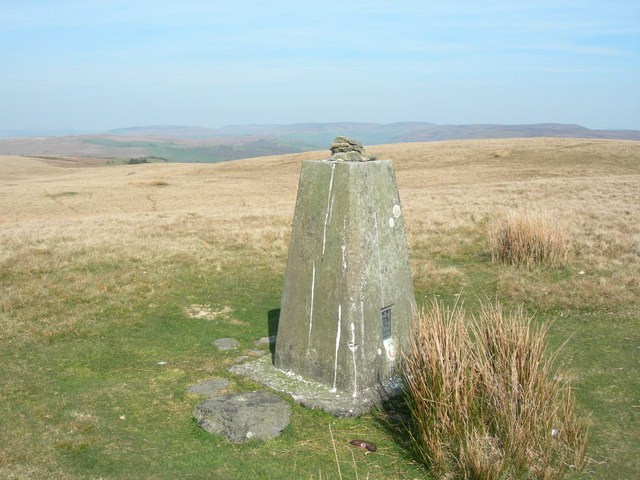
Banc y Celyn is a prominent hill located in the county of Brecknockshire, Wales. Situated in the southern part of the Brecon Beacons National Park, it is a popular destination for outdoor enthusiasts and nature lovers.
With an elevation of approximately 612 meters (2,008 feet), Banc y Celyn offers stunning panoramic views of the surrounding countryside. Its position within the national park allows visitors to admire the rugged beauty of the Brecon Beacons, with its rolling hills, deep valleys, and lush green landscapes.
The hill is characterized by its rocky terrain and is covered in heather, grasses, and wildflowers, providing a rich habitat for various plant and animal species. It is not uncommon to spot grazing sheep or wild ponies roaming freely.
Banc y Celyn is a haven for hikers and walkers, with several well-marked trails leading to its summit. The ascent can be challenging, particularly in adverse weather conditions, but the rewarding views from the top make it all worthwhile. On a clear day, one can see the peaks of Pen y Fan, Cribyn, and Corn Du, which are among the highest mountains in South Wales.
The hill also holds historical significance, with remnants of ancient settlements and burial mounds scattered across its slopes. These archaeological sites provide a glimpse into the area's rich past and offer a fascinating insight into the lives of those who once inhabited the region.
Overall, Banc y Celyn is a must-visit destination for those seeking breathtaking natural beauty, outdoor adventure, and a glimpse into Wales' rich history.
If you have any feedback on the listing, please let us know in the comments section below.
Banc y Celyn Images
Images are sourced within 2km of 52.107971/-3.3919399 or Grid Reference SO0446. Thanks to Geograph Open Source API. All images are credited.


Banc y Celyn is located at Grid Ref: SO0446 (Lat: 52.107971, Lng: -3.3919399)
Unitary Authority: Powys
Police Authority: Dyfed Powys
What 3 Words
///emails.starters.decorator. Near Builth Wells, Powys
Nearby Locations
Related Wikis

Brecon and Radnorshire (UK Parliament constituency)
Brecon and Radnorshire (Welsh: Brycheiniog a Sir Faesyfed) is a county constituency in Wales of the House of Commons of the Parliament of the United Kingdom...

Brecon and Radnorshire (Senedd constituency)
Brecon and Radnorshire (Welsh: Brycheiniog a Sir Faesyfed) is a constituency of the Senedd. It elects one Member of the Senedd by the first past the post...

Allt Cynhelyg
Allt Cynhelyg is a semi-natural oak-hazel woodland forming a Site of Special Scientific Interest in Brecknock, Powys, Wales. It has a notable natural population...
Alltmawr
Alltmawr is a village in the community of Erwood, Powys, Wales, which is 44 miles (71 km) from Cardiff and 144 miles (232 km) from London. St Mauritius...

Aberedw railway station
Aberedw railway station served the village of Aberedw in Powys, Wales. Aberedw Castle was demolished to build the station and some of the stone from the...

Aberedw
Aberedw is a village and community in Radnorshire, Powys, Wales. The community covers an area of 3,055 hectares (11.80 sq mi). Its population was 229,...
Duhonw
Duhonw is a rural community in Powys, Wales, to the south of Builth Wells (Welsh: Llanfair ym Muallt), in the historic county of Breconshire. Covering...
Aberedw Castle
The remains of Aberedw Castle, also known as 'Castle in Elfael Uwch Mynydd', are located at the small village of Aberedw in the county of Powys, Mid-Wales...
Related Videos

VW Road Trip: Hiking in the wilds of Radnorshire
A second trip in 'Scarlet', our VW Type 4 camper, to the beautiful uplands of quiet Radnorshire in the Welsh Marches. A taxing ...

Vanlife: A night on Cold Mountain
An overnighter in 'Buzz' , our Ex AA van camper. Wild Camping at nearly 2000' in the Powys hills.
Highlander Crusader Hammock and Tarp review solo hammock camping first time
Testing out a hammock and tarp plus other gear listed below. Hammock ...

April Fool on the Hill ! : Elan Valley
An unexpected opportunity to visit the Elan Valley area and bag a peak on April Fool's Day. Not for the first time I end up on a ...
Nearby Amenities
Located within 500m of 52.107971,-3.3919399Have you been to Banc y Celyn?
Leave your review of Banc y Celyn below (or comments, questions and feedback).