Beinn a' Chruachain

Hill, Mountain in Perthshire

Scotland

Beinn a' Chruachain

Allt Fearnach An old bridge crosses the burn here, although there is little sign of the footpath which it leads to.
Allt Fearnach Credit: Lis Burke

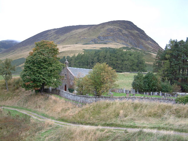
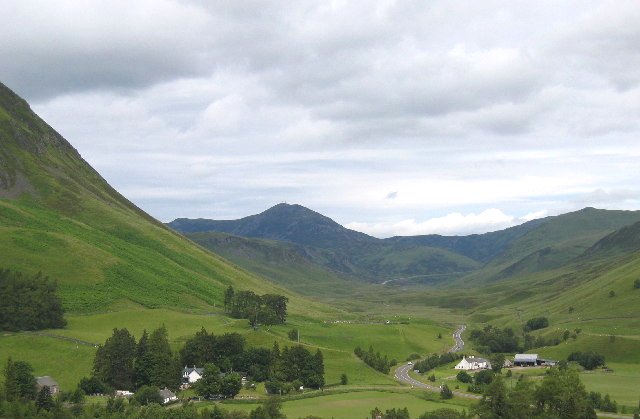
Beinn a' Chruachain is a prominent hill located in Perthshire, Scotland. It is part of the Grampian Mountains and stands at an elevation of 713 meters (2,339 feet). The hill is situated within the Loch Rannoch and Loch Tummel National Scenic Area, offering breathtaking views of the surrounding landscape.

The ascent of Beinn a' Chruachain begins from the small village of Rannoch Station, which is easily accessible by road and rail. The hill is a popular destination for hikers, who are drawn to its challenging yet rewarding trails. The most common route follows a path that leads up through the rugged terrain of the hillside, gradually gaining elevation. The final stretch to the summit involves scrambling over rocky sections, adding an element of excitement to the climb.

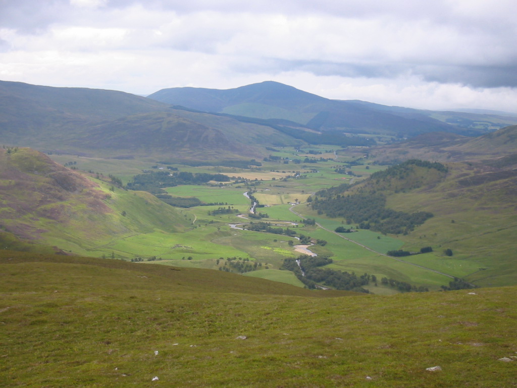
Once at the top, visitors are rewarded with panoramic views of the surrounding mountains and lochs. On a clear day, it is possible to see as far as the Ben Alder and Ben Nevis ranges. The summit itself is marked by a cairn, which serves as a point of reference and a resting spot for hikers.

Beinn a' Chruachain is known for its diverse flora and fauna. The hillside is covered in heather, and during the summer months, it bursts into a vibrant purple hue. The area is also home to various species of birds, including the golden eagle and peregrine falcon, which can often be spotted soaring through the skies.

Overall, Beinn a' Chruachain offers a challenging yet rewarding hiking experience, with stunning views and a chance to immerse oneself in the natural beauty of Perthshire.

If you have any feedback on the listing, please let us know in the comments section below.

Beinn a' Chruachain Images

Images are sourced within 2km of 56.80732/-3.5630594 or Grid Reference NO0469. Thanks to Geograph Open Source API. All images are credited.

Allt Fearnach An old bridge crosses the burn here, although there is little sign of the footpath which it leads to.
Allt Fearnach
An old bridge crosses the burn here, although there is little sign of the footpath which it leads to.
Gleann Fearnach Looking across the burn with Beinn a' Chruachain rising beyond it.
Gleann Fearnach
Looking across the burn with Beinn a' Chruachain rising beyond it.
Allt Fearnach The river is wide but shallow here.
Allt Fearnach
The river is wide but shallow here.
Cairn Tarmachain A golden plover (recognised by its call) stands out against the snow.
Cairn Tarmachain
A golden plover (recognised by its call) stands out against the snow.
Tussocks below  Carn Dearg Rough ground like this is the exception rather than the rule in Gleann Fearnach. View across Allt Ruigh nan Eas towards Carn Dearg.
Tussocks below Carn Dearg
Rough ground like this is the exception rather than the rule in Gleann Fearnach. View across Allt Ruigh nan Eas towards Carn Dearg.
Sròn Bhreachach Ridge running southwestward from Meall a' Choire Bhuidhe towards the Allt Ruigh nan Eas in Gleann Fearnach. Beinn a' Chruachain can be seen on the left. 
Very easy walking here.
Sròn Bhreachach
Ridge running southwestward from Meall a' Choire Bhuidhe towards the Allt Ruigh nan Eas in Gleann Fearnach. Beinn a' Chruachain can be seen on the left. Very easy walking here.
Track beneath Sròn Bhreachach A track, both vehicle and deer running towards Coire Domhain. View towards a snow patch between Carn Dearg and Meall Ruigh Mòr Thearlaich.
Track beneath Sròn Bhreachach
A track, both vehicle and deer running towards Coire Domhain. View towards a snow patch between Carn Dearg and Meall Ruigh Mòr Thearlaich.
Sheep, Coire Domhain Sheep grazing the headwall of Coire Domhain on Meall a' Choire Bhuidhe.
Sheep, Coire Domhain
Sheep grazing the headwall of Coire Domhain on Meall a' Choire Bhuidhe.
Forest edge Two deer disappeared into the forest as I arrived.
Forest edge
Two deer disappeared into the forest as I arrived.
Footbridge over the Allt Fearnach Footbridge over the Allt Fearnach - well used by Sheep.
Footbridge over the Allt Fearnach
Footbridge over the Allt Fearnach - well used by Sheep.
Allt Fearnach The view of Allt Fearnach, with Beinn a' Chruachain in the distance
Allt Fearnach
The view of Allt Fearnach, with Beinn a' Chruachain in the distance
Allt Fearnach The view of Allt Fearnach with the Allt Linne a'Bhuirein valley in the background.
Allt Fearnach
The view of Allt Fearnach with the Allt Linne a'Bhuirein valley in the background.
The Confluence of Allt Ruigh nan Eas with Allt Fearnach The view of the point where the Allt Ruigh nan Eas meets the Allt Fearnach.  Beinn Chruachain is in the background.
The Confluence of Allt Ruigh nan Eas with Allt Fearnach
The view of the point where the Allt Ruigh nan Eas meets the Allt Fearnach. Beinn Chruachain is in the background.
Daldhu road, Gleann Fearnach The tarmac road provided quick progress for the bikes to the cottage of Daldhu.  One had to be always ready though for the sheep and lambs of which there are lots in this glen.
Daldhu road, Gleann Fearnach
The tarmac road provided quick progress for the bikes to the cottage of Daldhu. One had to be always ready though for the sheep and lambs of which there are lots in this glen.
Allt Fearnach The river running through a green glen at the start of Summer. (Winter view: <a href="https://www.geograph.org.uk/photo/380332">NO0468 : Allt Fearnach</a>).  
It was a warm day and deer could be seen on the breezy ridge of Beinn a' Chruachain in the background.
Allt Fearnach
The river running through a green glen at the start of Summer. (Winter view: NO0468 : Allt Fearnach). It was a warm day and deer could be seen on the breezy ridge of Beinn a' Chruachain in the background.
Gleann Fearnach Haughs beside the Allt Fearnach with a view towards Beinn Bhuirich and Carn nan Gabhar.  The glen is very fertile and is mostly farmed.
Gleann Fearnach
Haughs beside the Allt Fearnach with a view towards Beinn Bhuirich and Carn nan Gabhar. The glen is very fertile and is mostly farmed.
Bridge over the Allt Fearnach One of the bridges leading to pastures on the east side of the glen. A track runs from here, under Beinn a' Chruachain (the hill in the picture) and on to Meall a' Choire Bhuidhe.
Bridge over the Allt Fearnach
One of the bridges leading to pastures on the east side of the glen. A track runs from here, under Beinn a' Chruachain (the hill in the picture) and on to Meall a' Choire Bhuidhe.
Ruin, Gleann Fearnach A two roomed building near an extensive set of gathering pens<a href="https://www.geograph.org.uk/photo/1865244">NO0468 : Ruined fank, Gleann Fearnach</a>. Gleann Fearnach is fertile and would once have supported a large population.
Ruin, Gleann Fearnach
A two roomed building near an extensive set of gathering pensNO0468 : Ruined fank, Gleann Fearnach. Gleann Fearnach is fertile and would once have supported a large population.
Show me another place!

Beinn a' Chruachain is located at Grid Ref: NO0469 (Lat: 56.80732, Lng: -3.5630594)

Unitary Authority: Perth and Kinross

Police Authority: Tayside

What 3 Words

///custodial.remix.insects. Near Pitlochry, Perth & Kinross

Nearby Locations

Beinn a' Chruachain

Related Wikis

Ben Vuirich

Ben Vuirich (903 m) is a mountain in the Grampian Mountains of Scotland. It is located in Perthshire, north of the town of Pitlochry. A mountain of heather...

Ben Gulabin

Ben Gulabin (806 m) is a mountain in the Mounth area of the Grampian Mountains in Scotland. It is located on the eastern side of the main A93 road between...

Dirnanean House

Dirnanean House is part of a private, traditional Highland estate located near Enochdhu in Moulin parish, Blairgowrie, Perth and Kinross, Scotland, 10...

Shee Water

The Shee Water (Scottish Gaelic: Sìdh / Uisge Sìdh) is a river in the highland portion of eastern Perth and Kinross, Scotland. The Allt a' Ghlinne Bhig...

Spittal of Glenshee

The Spittal of Glenshee (Scottish Gaelic: Spideal Ghlinn Sìdh, pronounced [ˈspitʲəl̪ˠ ʝliːɲ ˈʃiːʝ]) lies at the head of Glenshee in the highlands of eastern...

Glas Tulaichean

Glas Tulaichean (Scottish Gaelic: An Glas-Thulchan) is a large, complex mountain in the Mounth, Scotland. It is about 18 kilometres (11 mi) south of Braemar...

Kindrogan House

Kindrogan House is located near Enochdhu, Blairgowrie, Perth and Kinross in Moulin parish, at the head of Strath Ardle, 7 miles (11 km) ENE of Pitlochry...

Loch Loch

Loch Loch is a remote freshwater loch, located in Glen Loch in Perth and Kinross, some 9.5 miles north of Pitlochry, Scotland and is within the Forest...

Nearby Amenities

Located within 500m of 56.80732,-3.5630594
Beinn a'Chruachain
Ele: 612
Natural: peak
Lat/Long: 56.8074124/-3.5627322
The data included in this document is from www.openstreetmap.org. The data is made available under ODbL.

Have you been to Beinn a' Chruachain?

Leave your review of Beinn a' Chruachain below (or comments, questions and feedback).