Seat Hill

Hill, Mountain in Lanarkshire

Scotland

Seat Hill

Forest Access Near Tarbrax This track leaves the A70 to run alongside Boston Burn for a short distance.
Forest Access Near Tarbrax Credit: Mary and Angus Hogg

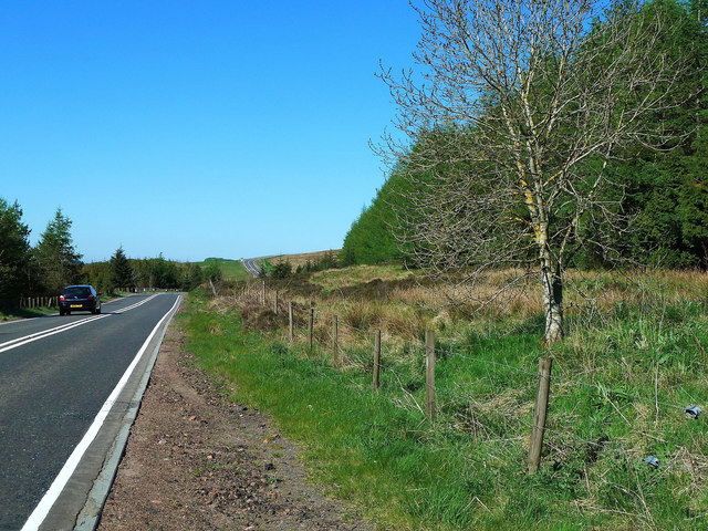
Seat Hill is a prominent hill located in Lanarkshire, Scotland. Situated in the Southern Uplands, it forms part of the picturesque Clyde Valley. With an elevation of approximately 446 meters (1,463 feet), it is a popular destination for outdoor enthusiasts and nature lovers.

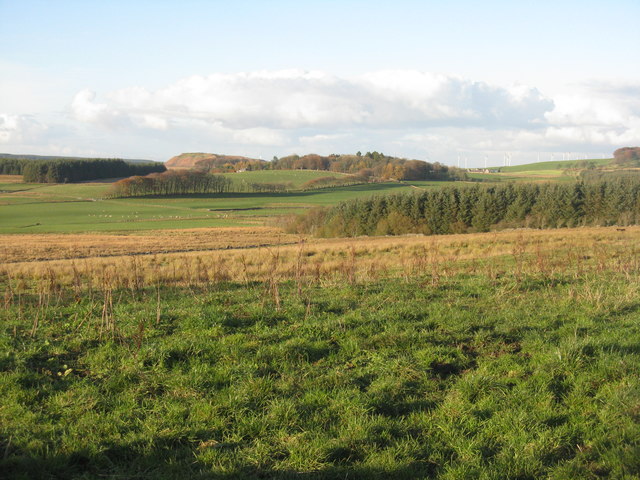
The hill is characterized by its distinct shape, resembling a seat or saddle when viewed from certain angles. It offers breathtaking panoramic views of the surrounding countryside, including the nearby towns of Lanark and Carluke. On clear days, it is possible to see as far as the hills of Tinto and the Campsie Fells.

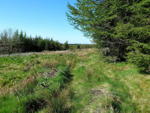
The terrain of Seat Hill is a mix of heather, grass, and rocky outcrops, making it a challenging yet rewarding climb for hikers and hillwalkers. There are various routes to reach the summit, each offering its own unique charm. Visitors can choose from well-established paths or opt for a more adventurous off-road experience.

Wildlife is abundant in the area surrounding Seat Hill. The hill is home to a diverse range of bird species, including peregrine falcons, kestrels, and red grouse. During the summer months, the slopes are adorned with colorful wildflowers, creating a stunning natural spectacle.

Seat Hill is easily accessible, with parking available at various points along the surrounding roads. It is a popular destination for locals and tourists alike, providing an opportunity to escape the hustle and bustle of city life and immerse oneself in the tranquility of nature. Whether one seeks a challenging hike or simply a peaceful stroll, Seat Hill offers an unforgettable experience for all.

If you have any feedback on the listing, please let us know in the comments section below.

Seat Hill Images

Images are sourced within 2km of 55.750753/-3.5375002 or Grid Reference NT0351. Thanks to Geograph Open Source API. All images are credited.

Forest Access Near Tarbrax This track leaves the A70 to run alongside Boston Burn for a short distance.
Forest Access Near Tarbrax
This track leaves the A70 to run alongside Boston Burn for a short distance.
Boston Burn Boston Burn separates two blocks of forestry on the Lang Whang, one of which has been harvested and replanted.
Boston Burn
Boston Burn separates two blocks of forestry on the Lang Whang, one of which has been harvested and replanted.
By Corse Law Forest The A70 on the edge of Corse Law Forest, looking in the Edinburgh direction.
By Corse Law Forest
The A70 on the edge of Corse Law Forest, looking in the Edinburgh direction.
Corse Law Forest Edge This forest lies alongside the Lang Whang between Carnwath and Edinburgh.
Corse Law Forest Edge
This forest lies alongside the Lang Whang between Carnwath and Edinburgh.
Cattle at Dykefoot Dairy cattle on a farm by the Lang Whang, near Edinburgh.
Cattle at Dykefoot
Dairy cattle on a farm by the Lang Whang, near Edinburgh.
Countryside by the A70 roadside, with wind turbines seen beyond
Old Enclosure near Path Junction I thought the boxes on the map at this spot might represent stone ruins of some sort. They clearly do not and this small area, once fenced off, is the only obvious thing to be seen. At dusk in this barren area certain things take on a sinister air, and I got the feeling that unpleasant things must have once gone on here!
Rather more curiously, there were low earthen  ramparts at the Northern end of this map feature (I didn't check the area South of this enclosure), running where the lines  on the map are drawn. There is no evidence of a former fence; nor is anything shown as being present at this spot on old maps.
Old Enclosure near Path Junction
I thought the boxes on the map at this spot might represent stone ruins of some sort. They clearly do not and this small area, once fenced off, is the only obvious thing to be seen. At dusk in this barren area certain things take on a sinister air, and I got the feeling that unpleasant things must have once gone on here! Rather more curiously, there were low earthen ramparts at the Northern end of this map feature (I didn't check the area South of this enclosure), running where the lines on the map are drawn. There is no evidence of a former fence; nor is anything shown as being present at this spot on old maps.
Old Quarry Site This is the Southernmost of two former quarries marked on the map on the Western approach to the small hill of Left Law. The 1859-surveyed OS map shows them as being disused even then, though a track to the site is still indicated.
The old map also indicates that a lime works was once present at the quarries. This basically involved burning the limestone at a high temperature, which causes the calcium carbonate contained in the rock to release carbon dioxide and turn into calcium oxide, or lime. The lime was, and still is, used for construction and as a fertilizer, amongst numerous other things. These days the lime added to fertilizer is just ground down limestone powder, but back when this quarry was operational there were no mills capable of grinding down stone, so they just used the burnt version.
Old Quarry Site
This is the Southernmost of two former quarries marked on the map on the Western approach to the small hill of Left Law. The 1859-surveyed OS map shows them as being disused even then, though a track to the site is still indicated. The old map also indicates that a lime works was once present at the quarries. This basically involved burning the limestone at a high temperature, which causes the calcium carbonate contained in the rock to release carbon dioxide and turn into calcium oxide, or lime. The lime was, and still is, used for construction and as a fertilizer, amongst numerous other things. These days the lime added to fertilizer is just ground down limestone powder, but back when this quarry was operational there were no mills capable of grinding down stone, so they just used the burnt version.
The Southern Pentland Landscape Whilst it could be argued that this is rather a dull picture it is certainly very representative! I took it because there is some unbelievably noisy water flowing through the peaty soil underneath the grass in the immediate foreground, which is on the North side of the wide grassy track heading SouthEast across the moorland here. Strangely I passed this same spot the day before and there was no noise at all.
The turbines on the horizon belong either to the Easteryardhouse or Polkelly windfarms (I can't remember if these are their official names but that is what they usually get called), or perhaps both.
The Southern Pentland Landscape
Whilst it could be argued that this is rather a dull picture it is certainly very representative! I took it because there is some unbelievably noisy water flowing through the peaty soil underneath the grass in the immediate foreground, which is on the North side of the wide grassy track heading SouthEast across the moorland here. Strangely I passed this same spot the day before and there was no noise at all. The turbines on the horizon belong either to the Easteryardhouse or Polkelly windfarms (I can't remember if these are their official names but that is what they usually get called), or perhaps both.
Old Boundary Stone The small pyramid-topped boundary stone is on the other side of the very pretty Westruther Burn, which, to me, contains a surprisingly large amount of water. Considering that the OS map key includes 'BS : Boundary Stone' there is really no excuse for it to be marked on the map as simply 'Stone'. Whilst I probably would have wandered along for a look anyway I was disappointed not to find some impressive geological feature here. Come on OS - it is, after all, marked as a boundary stone on earlier maps as well!
The writing on the far side of the stone reads : 'BOUNDARY BETWEEN THE PARISHES OF CARNWATH AND DUNSYRE'. There is also 'C D' inscribed on the top of the stone but I have no idea what this might stand for.
Old Boundary Stone
The small pyramid-topped boundary stone is on the other side of the very pretty Westruther Burn, which, to me, contains a surprisingly large amount of water. Considering that the OS map key includes 'BS : Boundary Stone' there is really no excuse for it to be marked on the map as simply 'Stone'. Whilst I probably would have wandered along for a look anyway I was disappointed not to find some impressive geological feature here. Come on OS - it is, after all, marked as a boundary stone on earlier maps as well! The writing on the far side of the stone reads : 'BOUNDARY BETWEEN THE PARISHES OF CARNWATH AND DUNSYRE'. There is also 'C D' inscribed on the top of the stone but I have no idea what this might stand for.
Track through Felled Forest A desolate route to a desolate place - the very remote-feeling, and slightly eerie Southern end of the Pentlands. Somewhere up ahead on the left, amongst the carnage, is Lingy Knowe, which must have been christened before the trees got planted. As it is certainly not a very discernable natural feature these days. It probably never was much to write home about anyway - it just looks like a slightly flatter bit of an incline judging by the map.
Track through Felled Forest
A desolate route to a desolate place - the very remote-feeling, and slightly eerie Southern end of the Pentlands. Somewhere up ahead on the left, amongst the carnage, is Lingy Knowe, which must have been christened before the trees got planted. As it is certainly not a very discernable natural feature these days. It probably never was much to write home about anyway - it just looks like a slightly flatter bit of an incline judging by the map.
Gate onto moorland near Tarbrax
Lone bush on moorland near Tarbrax
Planting patterns in the valley of the Adder Burn The water of the burn will eventually flow into the River Clyde - this is near the watershed between Clyde, Forth and Tweed. I'm not sure about the green strips - an unlikely place for a forestry nursery; perhaps Christmas trees? Ground truth, 4 months later, confirms that this is indeed a Christmas tree plantation <a title="https://www.geograph.org.uk/search.php?i=88518977" href="https://www.geograph.org.uk/search.php?i=88518977">Link</a> .
Planting patterns in the valley of the Adder Burn
The water of the burn will eventually flow into the River Clyde - this is near the watershed between Clyde, Forth and Tweed. I'm not sure about the green strips - an unlikely place for a forestry nursery; perhaps Christmas trees? Ground truth, 4 months later, confirms that this is indeed a Christmas tree plantation Link .
Rough pasture, looking towards Tarbrax With better grass in the mid-distance.
Rough pasture, looking towards Tarbrax
With better grass in the mid-distance.
Forestry on Seat Hill Some clearance of large, but not mature, trees. Large Christmas trees, with small trees in the foreground.
Forestry on Seat Hill
Some clearance of large, but not mature, trees. Large Christmas trees, with small trees in the foreground.
Muirhall Wind Farm Four of ten turbines, beyond Dykefoot. Operational since 2010, with 6 turbines originally <span class="nowrap"><a title="https://muirhallenergy.co.uk/projects/muirhall-wind-farm/," rel="nofollow ugc noopener" href="https://muirhallenergy.co.uk/projects/muirhall-wind-farm/,">Link</a><img style="margin-left:2px;" alt="External link" title="External link - shift click to open in new window" src="https://s1.geograph.org.uk/img/external.png" width="10" height="10"/></span> it has now expanded, with 10 shown on current OS mapping .
Muirhall Wind Farm
Four of ten turbines, beyond Dykefoot. Operational since 2010, with 6 turbines originally LinkExternal link it has now expanded, with 10 shown on current OS mapping .
Roadside rushes Looking east from the A70, with the Pentland Hills beyond.
Roadside rushes
Looking east from the A70, with the Pentland Hills beyond.
Show me another place!

Seat Hill is located at Grid Ref: NT0351 (Lat: 55.750753, Lng: -3.5375002)

Unitary Authority: South Lanarkshire

Police Authority: Lanarkshire

What 3 Words

///watchdogs.spicy.dairy. Near Carnwath, South Lanarkshire

Nearby Locations

Seat Hill

Related Wikis

Tarbrax

Tarbrax (Scottish Gaelic: "An Tòrr Breac" - meaning "the speckled tor") is a small village in the Parish of Carnwath, South Lanarkshire, Scotland. It...

Little Sparta

Little Sparta is a garden at Dunsyre in the Pentland Hills in South Lanarkshire, Scotland, created by artist and poet Ian Hamilton Finlay and his wife...

Auchengray

Auchengray is a small village in South Lanarkshire, Scotland. == Overview == It has a small church whose architect was Frederick Thomas Pilkington (1832...

Ampherlaw House

Ampherlaw House is a manor house in Lanarkshire, Scotland, near the village of Carnwath and one of the former possessions of the Somerville family. It...

Nearby Amenities

Located within 500m of 55.750753,-3.5375002
Seat Hill
Natural: peak
Wikidata: Q24661174
Lat/Long: 55.7507543/-3.5373831
The data included in this document is from www.openstreetmap.org. The data is made available under ODbL.

Have you been to Seat Hill?

Leave your review of Seat Hill below (or comments, questions and feedback).