Carn Dallaig

Hill, Mountain in Perthshire

Scotland

Carn Dallaig

A wet midgy hillside The water underfoot and in the atmosphere was immediately apparent, but the sheer quantity of midges on these slopes above the Allt Fearnach only hit us when we stopped to take photographs.
A wet midgy hillside Credit: Lis Burke

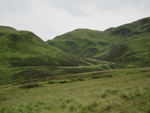
Carn Dallaig is a prominent hill located in Perthshire, Scotland. It is part of the Grampian Mountains, which stretch across the central and northeastern regions of the country. Standing at an elevation of approximately 993 meters (3,258 feet), Carn Dallaig offers breathtaking panoramic views of the surrounding landscapes.

The hill is characterized by its rugged and rocky terrain, making it a popular destination for hikers and outdoor enthusiasts. Its slopes are covered in heather and grasses, providing a picturesque backdrop during the summer months. The hill's summit is marked by a cairn, a man-made pile of stones that has historical significance in Scottish culture.

Carn Dallaig is situated within close proximity to various other natural attractions, including Loch Rannoch and the picturesque village of Kinloch Rannoch. It is also in close proximity to Schiehallion, another prominent mountain in the area. The hill attracts visitors throughout the year, with different seasons offering unique experiences. During the winter, the hill is often covered in a blanket of snow, making it a popular spot for winter sports such as skiing and snowboarding.

Access to Carn Dallaig is relatively straightforward, with several well-marked hiking trails leading to the summit. These trails vary in difficulty, catering to both experienced hikers seeking a challenge and beginners looking for a more relaxed trek.

Overall, Carn Dallaig is a stunning natural landmark in Perthshire, offering visitors the opportunity to immerse themselves in the beauty of the Scottish Highlands.

If you have any feedback on the listing, please let us know in the comments section below.

Carn Dallaig Images

Images are sourced within 2km of 56.85604/-3.6135538 or Grid Reference NO0175. Thanks to Geograph Open Source API. All images are credited.

A wet midgy hillside The water underfoot and in the atmosphere was immediately apparent, but the sheer quantity of midges on these slopes above the Allt Fearnach only hit us when we stopped to take photographs.
A wet midgy hillside
The water underfoot and in the atmosphere was immediately apparent, but the sheer quantity of midges on these slopes above the Allt Fearnach only hit us when we stopped to take photographs.
Towards Bràigh Fèith Ghiubhsachain Looking towards Bràigh Fèith Ghiubhsachain from the track which climbs up beside the Allt Fearnach. It was raining.
Towards Bràigh Fèith Ghiubhsachain
Looking towards Bràigh Fèith Ghiubhsachain from the track which climbs up beside the Allt Fearnach. It was raining.
Looking down the track A rather hurried shot due to the presence of both rain and midges. One did not want to hang around at all.
Looking down the track
A rather hurried shot due to the presence of both rain and midges. One did not want to hang around at all.
Across the Allt Fearnach From the slopes just above the track there are good views right across this glen, with Beinn a'Ghlo unfortunately shrouded in low cloud.
Across the Allt Fearnach
From the slopes just above the track there are good views right across this glen, with Beinn a'Ghlo unfortunately shrouded in low cloud.
Up the track Looking up the track as it climbs beside the Allt Fearnach.
Up the track
Looking up the track as it climbs beside the Allt Fearnach.
Sheep descending into Gleann Fearnach The sheep soon tired of descending the track in front of us, and turned aside. As the rain cleared the view of Gleann Fearnach ahead became increasingly attractive.
Sheep descending into Gleann Fearnach
The sheep soon tired of descending the track in front of us, and turned aside. As the rain cleared the view of Gleann Fearnach ahead became increasingly attractive.
Glen Fearnach track A good track descends Glen Fearnach towards Daldhu.
Glen Fearnach track
A good track descends Glen Fearnach towards Daldhu.
Hillside below Carn Dallaig Taken during a short break in the rain. Unfortunately the rain didn't discourage the midges. I'm still itching two days later.
Hillside below Carn Dallaig
Taken during a short break in the rain. Unfortunately the rain didn't discourage the midges. I'm still itching two days later.
Track to Fearlar Lodge The track climbs to its highest point on the way to the remote lodge.
Track to Fearlar Lodge
The track climbs to its highest point on the way to the remote lodge.
Track to Daldhu The track from Fealar Lodge descends to the solitary house at Daldhu.
Track to Daldhu
The track from Fealar Lodge descends to the solitary house at Daldhu.
Allt Fearnach A track can be seen to the right of the burn, and the ridge of Braigh Feith Ghiubhsachain fills the skyline. Taken in light rain, while being chased by midges.
Allt Fearnach
A track can be seen to the right of the burn, and the ridge of Braigh Feith Ghiubhsachain fills the skyline. Taken in light rain, while being chased by midges.
Below Braigh Feith Ghiubhsachain The steep slopes of this ridge form the western side of Glen Fearnach here.
Below Braigh Feith Ghiubhsachain
The steep slopes of this ridge form the western side of Glen Fearnach here.
Faire Ghlinne Mhoir A view towards Faire Ghlinne Mhoir, situated on the south-west flank of Glas Tulaichean, and commanding fine views into Gleann Mhor (just visible on the right of the image) . This image was taken in a gap in heavy cloud, with visibility on the summit of the nearby Munro Glas Tulaichean down to a few metres.
Faire Ghlinne Mhoir
A view towards Faire Ghlinne Mhoir, situated on the south-west flank of Glas Tulaichean, and commanding fine views into Gleann Mhor (just visible on the right of the image) . This image was taken in a gap in heavy cloud, with visibility on the summit of the nearby Munro Glas Tulaichean down to a few metres.
Track on Clais Odhar A track on Clais Odhar, just visible after recent snowfall. Temperatures are well below freezing on Clais Odhar, situated to the west of the Munro Glas Tulaichean
Track on Clais Odhar
A track on Clais Odhar, just visible after recent snowfall. Temperatures are well below freezing on Clais Odhar, situated to the west of the Munro Glas Tulaichean
Western slopes of Clais Odhar The western flank of Clais Odhar, dusted with snow in late November. This image was taken during a gap in otherwise heavy cloud, which has completely shrouded the nearby summit of Glas Tulaichean. The upper region of Gleann Fearnach can be seen in the distance.
Western slopes of Clais Odhar
The western flank of Clais Odhar, dusted with snow in late November. This image was taken during a gap in otherwise heavy cloud, which has completely shrouded the nearby summit of Glas Tulaichean. The upper region of Gleann Fearnach can be seen in the distance.
South west ridge of Faire Ghlinne Mhoir The snow covered south western flank of Faire Ghlinne Mhoir, glimpsed in a brief window in heavy cloud covering the slopes above Gleann Mor.
South west ridge of Faire Ghlinne Mhoir
The snow covered south western flank of Faire Ghlinne Mhoir, glimpsed in a brief window in heavy cloud covering the slopes above Gleann Mor.
View across Gleann Mòr A view across Gleann Mòr from the lower (southern) slopes of Carn an Righ. A lengthy cornice can be seen on the western flank of the Munro Glas Tulaichean.
View across Gleann Mòr
A view across Gleann Mòr from the lower (southern) slopes of Carn an Righ. A lengthy cornice can be seen on the western flank of the Munro Glas Tulaichean.
South-western slopes of Stac na h-Iolair Steep ground, with exposed rock and scree on the south western slopes of Stac na h-Iolair, above Gleann Mòr.
South-western slopes of Stac na h-Iolair
Steep ground, with exposed rock and scree on the south western slopes of Stac na h-Iolair, above Gleann Mòr.
Show me another place!

Carn Dallaig is located at Grid Ref: NO0175 (Lat: 56.85604, Lng: -3.6135538)

Unitary Authority: Perth and Kinross

Police Authority: Tayside

What 3 Words

///oxidation.luckier.bidder. Near Inverey, Aberdeenshire

Related Wikis

Loch Loch

Loch Loch is a remote freshwater loch, located in Glen Loch in Perth and Kinross, some 9.5 miles north of Pitlochry, Scotland and is within the Forest...

Glas Tulaichean

Glas Tulaichean (Scottish Gaelic: An Glas-Thulchan) is a large, complex mountain in the Mounth, Scotland. It is about 18 kilometres (11 mi) south of Braemar...

Beinn Iutharn Mhòr

Beinn Iutharn Mhor (1,045 m) is a mountain in the Grampian Mountains of Scotland. It lies north of Glen Shee on the Aberdeenshire and Perthshire border...

Ben Vuirich

Ben Vuirich (903 m) is a mountain in the Grampian Mountains of Scotland. It is located in Perthshire, north of the town of Pitlochry. A mountain of heather...

Have you been to Carn Dallaig?

Leave your review of Carn Dallaig below (or comments, questions and feedback).