Bràigh Fèith Ghiubhsachain

Hill, Mountain in Perthshire

Scotland

Bràigh Fèith Ghiubhsachain

Tracks through Glen Loch The track on the left is the main path leading up Glen Loch to the shielings. The one on the right is deceptive - in theory it should lead over higher ground towards Loch Loch, but it disappears in thick heather fairly soon. The summits of Beinn a'Ghlo covered in a mushroom cloud.
Tracks through Glen Loch Credit: Aleks Scholz

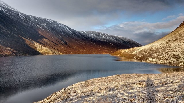
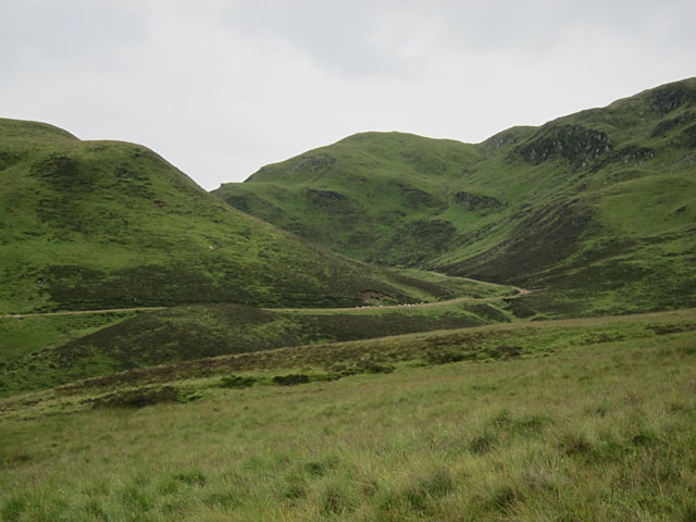
Bràigh Fèith Ghiubhsachain is a prominent hill located in the county of Perthshire, Scotland. It is part of the Grampian Mountains range and stands at an impressive height of 1,044 meters (3,425 feet). The hill is situated in a remote and rugged area, providing breathtaking views of the surrounding landscape.

The terrain of Bràigh Fèith Ghiubhsachain is characterized by steep slopes, rocky outcrops, and a diverse range of flora and fauna. It is a popular destination for hikers and mountaineers who are drawn to its challenging but rewarding trails. The ascent to the summit can be quite demanding, but the panoramic vistas of Perthshire and beyond make it well worth the effort.

The hill boasts a rich history, with evidence of previous human activity dating back thousands of years. There are remnants of ancient settlements and burial sites, providing a glimpse into the lives of early inhabitants. Visitors can also find traces of old droving routes, which were once used for the movement of livestock.

Bràigh Fèith Ghiubhsachain is part of a larger nature reserve, ensuring the preservation of its natural beauty and biodiversity. It is home to a variety of plant and animal species, including heather, mosses, red deer, and golden eagles. The hill's remote location and unspoiled environment contribute to its appeal as a sanctuary for wildlife.

Whether one seeks a challenging hike, a glimpse into history, or an opportunity to connect with nature, Bràigh Fèith Ghiubhsachain offers a memorable experience for outdoor enthusiasts. Its towering presence and awe-inspiring vistas make it a must-visit destination in Perthshire.

If you have any feedback on the listing, please let us know in the comments section below.

Bràigh Fèith Ghiubhsachain Images

Images are sourced within 2km of 56.844073/-3.6383201 or Grid Reference NO0073. Thanks to Geograph Open Source API. All images are credited.

Tracks through Glen Loch The track on the left is the main path leading up Glen Loch to the shielings. The one on the right is deceptive - in theory it should lead over higher ground towards Loch Loch, but it disappears in thick heather fairly soon. The summits of Beinn a'Ghlo covered in a mushroom cloud.
Tracks through Glen Loch
The track on the left is the main path leading up Glen Loch to the shielings. The one on the right is deceptive - in theory it should lead over higher ground towards Loch Loch, but it disappears in thick heather fairly soon. The summits of Beinn a'Ghlo covered in a mushroom cloud.
Loch Loch This view is from the summit of Meall Gharran (NN9776). Loch Loch does seem to be a rather odd name.
Loch Loch
This view is from the summit of Meall Gharran (NN9776). Loch Loch does seem to be a rather odd name.
Sròn nan Dias and Loch Loch
Bothan Ruigh Sròn nan Dias
Loch Loch Loch Loch in Perthshire, as seen from Sron nan Dias, a limestone spur to the east of Carn nan Gabhar.
Loch Loch
Loch Loch in Perthshire, as seen from Sron nan Dias, a limestone spur to the east of Carn nan Gabhar.
Bothan Ruigh Sron nan Dias The ruined bothy just below Sron nan Dias, western wall with fireplace and cupboards.
Bothan Ruigh Sron nan Dias
The ruined bothy just below Sron nan Dias, western wall with fireplace and cupboards.
Loch Loch after snow storm The beach at the southern end of Loch Loch, on a sunny morning after a snow storm.
Loch Loch after snow storm
The beach at the southern end of Loch Loch, on a sunny morning after a snow storm.
The deep part of Loch Loch This picture, taken from one of the protruding fingers of land that almost cut the loch in half, shows the part of Loch Loch that is deepest according to the OS map. The shape of the shoreline has been shaped by landslides on both sides. A faint path runs the eastern side of the loch.
The deep part of Loch Loch
This picture, taken from one of the protruding fingers of land that almost cut the loch in half, shows the part of Loch Loch that is deepest according to the OS map. The shape of the shoreline has been shaped by landslides on both sides. A faint path runs the eastern side of the loch.
Lochan at the edge of Creag an Loch Beinn a' Ghlo beyond.
Lochan at the edge of Creag an Loch
Beinn a' Ghlo beyond.
Allt Glen Loch This burn flows away from Glen Loch towards Glen Fearnach, but is not the outflow from Loch Loch.
Allt Glen Loch
This burn flows away from Glen Loch towards Glen Fearnach, but is not the outflow from Loch Loch.
Glen Loch A steady climb up the track is made pleasant by the scenery.
Glen Loch
A steady climb up the track is made pleasant by the scenery.
A wet midgy hillside The water underfoot and in the atmosphere was immediately apparent, but the sheer quantity of midges on these slopes above the Allt Fearnach only hit us when we stopped to take photographs.
A wet midgy hillside
The water underfoot and in the atmosphere was immediately apparent, but the sheer quantity of midges on these slopes above the Allt Fearnach only hit us when we stopped to take photographs.
Towards Bràigh Fèith Ghiubhsachain Looking towards Bràigh Fèith Ghiubhsachain from the track which climbs up beside the Allt Fearnach. It was raining.
Towards Bràigh Fèith Ghiubhsachain
Looking towards Bràigh Fèith Ghiubhsachain from the track which climbs up beside the Allt Fearnach. It was raining.
Looking down the track A rather hurried shot due to the presence of both rain and midges. One did not want to hang around at all.
Looking down the track
A rather hurried shot due to the presence of both rain and midges. One did not want to hang around at all.
Across the Allt Fearnach From the slopes just above the track there are good views right across this glen, with Beinn a'Ghlo unfortunately shrouded in low cloud.
Across the Allt Fearnach
From the slopes just above the track there are good views right across this glen, with Beinn a'Ghlo unfortunately shrouded in low cloud.
Up the track Looking up the track as it climbs beside the Allt Fearnach.
Up the track
Looking up the track as it climbs beside the Allt Fearnach.
Gleann Fearnach Looking down the track as it descends into the lower, less rugged section of Gleann Fearnach.
Gleann Fearnach
Looking down the track as it descends into the lower, less rugged section of Gleann Fearnach.
Sheep descending into Gleann Fearnach The sheep soon tired of descending the track in front of us, and turned aside. As the rain cleared the view of Gleann Fearnach ahead became increasingly attractive.
Sheep descending into Gleann Fearnach
The sheep soon tired of descending the track in front of us, and turned aside. As the rain cleared the view of Gleann Fearnach ahead became increasingly attractive.
Show me another place!

Bràigh Fèith Ghiubhsachain is located at Grid Ref: NO0073 (Lat: 56.844073, Lng: -3.6383201)

Unitary Authority: Perth and Kinross

Police Authority: Tayside

What 3 Words

///adjusting.buckling.later. Near Blair Atholl, Perth & Kinross

Related Wikis

Loch Loch

Loch Loch is a remote freshwater loch, located in Glen Loch in Perth and Kinross, some 9.5 miles north of Pitlochry, Scotland and is within the Forest...

Ben Vuirich

Ben Vuirich (903 m) is a mountain in the Grampian Mountains of Scotland. It is located in Perthshire, north of the town of Pitlochry. A mountain of heather...

Glas Tulaichean

Glas Tulaichean (Scottish Gaelic: An Glas-Thulchan) is a large, complex mountain in the Mounth, Scotland. It is about 18 kilometres (11 mi) south of Braemar...

Beinn a' Ghlò

Beinn a’ Ghlò is a Scottish mountain situated roughly 10 km (6 mi) north east of Blair Atholl in the Forest of Atholl in between Glen Tilt and Glen Loch...
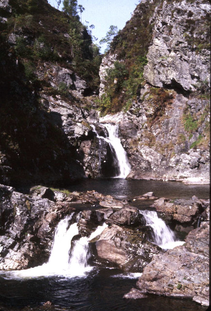
Falls of Tarf

The Falls of Tarf is a waterfall on the Tarf Water in the eastern Highlands of Scotland. Immediately downstream of the falls the Tarf is joined by a second...

Beinn Iutharn Mhòr

Beinn Iutharn Mhor (1,045 m) is a mountain in the Grampian Mountains of Scotland. It lies north of Glen Shee on the Aberdeenshire and Perthshire border...

Càrn Liath (Munro)

Carn Liath (976 m) is a mountain in the Grampian Mountains of Scotland. It lies east of Blair Atholl in Perthshire, Scotland. Although belonging to the...

Loch nan Eun

Loch nan Eun is a remote freshwater loch, located in Gleann Taitneach in the Grampian Mountains, Perth and Kinross, some 4.5 miles west of The Cairnwell...

Nearby Amenities

Located within 500m of 56.844073,-3.6383201
Bràigh Feith Chiubhsachain
Ele: 722
Natural: peak
Lat/Long: 56.8438587/-3.6392225
The data included in this document is from www.openstreetmap.org. The data is made available under ODbL.

Have you been to Bràigh Fèith Ghiubhsachain?

Leave your review of Bràigh Fèith Ghiubhsachain below (or comments, questions and feedback).