Mynydd Ty'n-tyle

Hill, Mountain in Glamorgan

Wales

Mynydd Ty'n-tyle

Field entrance at Bodryngallt Farm
Field entrance at Bodryngallt Farm Credit: Alan Hughes

Mynydd Ty'n-tyle, also known as Ty'n-tyle Hill or Ty'n-tyle Mountain, is located in Glamorgan, a historic county in Wales, United Kingdom. Situated in the southern part of the country, it is part of the larger South Wales Valleys region.

Mynydd Ty'n-tyle is a prominent hill/mountain that rises to an elevation of approximately 314 meters (1,030 feet) above sea level. It is surrounded by the picturesque countryside of Glamorgan, offering breathtaking views of the rolling hills, verdant farmland, and occasional patches of woodland.

This natural landmark holds great significance both in terms of its geological and historical features. The hill/mountain is primarily composed of sandstone, a sedimentary rock that is characteristic of the region. The rock formations found here provide valuable insights into the geological history of the area.

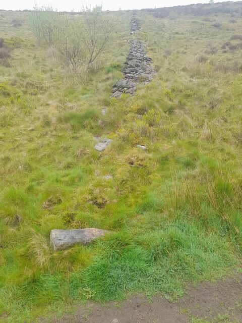
Moreover, Mynydd Ty'n-tyle has witnessed human activity dating back centuries. It is believed that the hill/mountain served as a site for iron mining during the Industrial Revolution. The remnants of old mine workings and quarries can still be found scattered across its slopes.

Today, Mynydd Ty'n-tyle attracts outdoor enthusiasts, nature lovers, and hikers who come to explore its trails and enjoy the stunning vistas it offers. The hill/mountain is accessible via various footpaths and bridleways, making it an ideal destination for a day of outdoor recreation.

Overall, Mynydd Ty'n-tyle stands as a notable geographical feature, offering both natural beauty and historical significance to visitors and locals alike in Glamorgan, Wales.

If you have any feedback on the listing, please let us know in the comments section below.

Mynydd Ty'n-tyle Images

Images are sourced within 2km of 51.653536/-3.4531554 or Grid Reference SS9995. Thanks to Geograph Open Source API. All images are credited.

Field entrance at Bodryngallt Farm
Ystrad Rhondda station Looking south from the northbound platform as the train's crew obtain the signalling token for the section to Treherbert.
Ystrad Rhondda station
Looking south from the northbound platform as the train's crew obtain the signalling token for the section to Treherbert.
Ordnance Survey Cut Mark This OS pivot can be found on the boulder at the wall junction. It marks a point 1368.0ft above mean sea level.
Ordnance Survey Cut Mark
This OS pivot can be found on the boulder at the wall junction. It marks a point 1368.0ft above mean sea level.
Ordnance Survey Pivot This OS pivot can be found on the stone against the fence. It marks a point 1409.7ft above mean sea level.
Ordnance Survey Pivot
This OS pivot can be found on the stone against the fence. It marks a point 1409.7ft above mean sea level.
Cefn-y-Rhondda - Cairn 1 A round cairn 5m in diameter and 0.5m high.
Cefn-y-Rhondda - Cairn 1
A round cairn 5m in diameter and 0.5m high.
Ordnance Survey Rivet This OS rivet can be found on the boulder at the gateway. It marks a point 371.448m above mean sea level.
Ordnance Survey Rivet
This OS rivet can be found on the boulder at the gateway. It marks a point 371.448m above mean sea level.
Ordnance Survey Rivet This OS rivet can be found on a stone east side of the path junction. It marks a point 403.098m above mean sea level.
Ordnance Survey Rivet
This OS rivet can be found on a stone east side of the path junction. It marks a point 403.098m above mean sea level.
Ordnance Survey Rivet This OS rivet can be found on a stone west side of path. It marks a point 401.391m above mean sea level.
Ordnance Survey Rivet
This OS rivet can be found on a stone west side of path. It marks a point 401.391m above mean sea level.
Ordnance Survey Rivet This OS rivet can be found on the rock NW side of the path.. It marks a point 391.738m above mean sea level.
Ordnance Survey Rivet
This OS rivet can be found on the rock NW side of the path.. It marks a point 391.738m above mean sea level.
Ordnance Survey Rivet This OS rivet can be found on the rock outcrop north side of the path. It marks a point 303.766m above mean sea level.
Ordnance Survey Rivet
This OS rivet can be found on the rock outcrop north side of the path. It marks a point 303.766m above mean sea level.
Remains of Dry-Stone Wall
Ordnance Survey Cut Mark This OS cut mark can be found on No141 Tyntyla Road. It marks a point 147.604m above mean sea level.
Ordnance Survey Cut Mark
This OS cut mark can be found on No141 Tyntyla Road. It marks a point 147.604m above mean sea level.
Maerdy Road Industrial Estate Chubb Fire complex, which is located on the Eastern side of the Industrial Estate.  Photograph facing North Westerly.
Maerdy Road Industrial Estate
Chubb Fire complex, which is located on the Eastern side of the Industrial Estate. Photograph facing North Westerly.
Ferndale Fire Station Ferndale Fire Station, Cross Lake Street, Ferndale, now part of South Wales Fire & Rescue Service. This replaced the previous fire station, which still exists in Lake Street <a href="https://www.geograph.org.uk/photo/460907">SS9996 : Ferndale Old Fire Station</a>.
Ferndale Fire Station
Ferndale Fire Station, Cross Lake Street, Ferndale, now part of South Wales Fire & Rescue Service. This replaced the previous fire station, which still exists in Lake Street SS9996 : Ferndale Old Fire Station.
Ferndale Old Fire Station Ferndale Old Fire Station, Lake Street. After the opening of the new Fire Station, Ferndale Old Fire Station was converted and used as an electronics workshop.  The new fire station <a href="https://www.geograph.org.uk/photo/460901">SS9996 : Ferndale Fire Station</a> looks down on it from higher up the valley.  This building was demolished circa 2008 and the site is now an entrance to a car park and boasts a model village created with the help of local school children.
Ferndale Old Fire Station
Ferndale Old Fire Station, Lake Street. After the opening of the new Fire Station, Ferndale Old Fire Station was converted and used as an electronics workshop. The new fire station SS9996 : Ferndale Fire Station looks down on it from higher up the valley. This building was demolished circa 2008 and the site is now an entrance to a car park and boasts a model village created with the help of local school children.
Looking across Highfield into Maerdy A view from the mountain across Highfield and on towards Maerdy.
Looking across Highfield into Maerdy
A view from the mountain across Highfield and on towards Maerdy.
Ystrad Rhondda: B4512 The road towards Tylorstown ascends steeply.
Ystrad Rhondda: B4512
The road towards Tylorstown ascends steeply.
Entrance to Nant y Gwydden Forestry Commission picnic site
Show me another place!

Mynydd Ty'n-tyle is located at Grid Ref: SS9995 (Lat: 51.653536, Lng: -3.4531554)

Unitary Authority: Rhondda Cynon Taf

Police Authority: South Wales

What 3 Words

///proof.wrong.shin. Near Rhondda, Rhondda Cynon Taf

Nearby Locations

Mynydd Ty'n-tyle

Related Wikis

Cynon Valley

Cynon Valley (Welsh: Cwm Cynon) is a former coal mining valley in Wales. It lies between Rhondda and the Merthyr Valley and takes its name from the River...

Cynon Valley (Senedd constituency)

Cynon Valley (Welsh: Cwm Cynon) is a constituency of the Senedd. It elects one Member of the Senedd by the first past the post method of election. It is...

Cynon Valley (UK Parliament constituency)

Cynon Valley (Welsh: Cwm Cynon) is a constituency in Wales represented in the House of Commons of the UK Parliament since 2019 by Beth Winter of the Labour...

Ferndale Colliery

Ferndale Colliery was a series of nine coal mines, located close to the village of Ferndale, Rhondda Cynon Taf in the Rhondda Valley, South Wales. ��2...

Nearby Amenities

Located within 500m of 51.653536,-3.4531554
Generator Method: wind_turbine
Generator Source: wind
Generator Type: horizontal_axis
Power: generator
Lat/Long: 51.6554341/-3.4592023
Generator Method: wind_turbine
Generator Source: wind
Generator Type: horizontal_axis
Power: generator
Lat/Long: 51.6539115/-3.4577834
Generator Method: wind_turbine
Generator Source: wind
Generator Type: horizontal_axis
Power: generator
Lat/Long: 51.6524254/-3.4565603
Power: pole
Lat/Long: 51.6501019/-3.450483
Power: pole
Lat/Long: 51.6510921/-3.4508034
Location Transition: yes
Power: pole
Lat/Long: 51.651983/-3.4510766
The data included in this document is from www.openstreetmap.org. The data is made available under ODbL.

Have you been to Mynydd Ty'n-tyle?

Leave your review of Mynydd Ty'n-tyle below (or comments, questions and feedback).