Auchlinsky Hill

Hill, Mountain in Perthshire

Scotland

Auchlinsky Hill

Castlehill Reservoir, Glen Devon
Castlehill Reservoir, Glen Devon Credit: Richard Webb

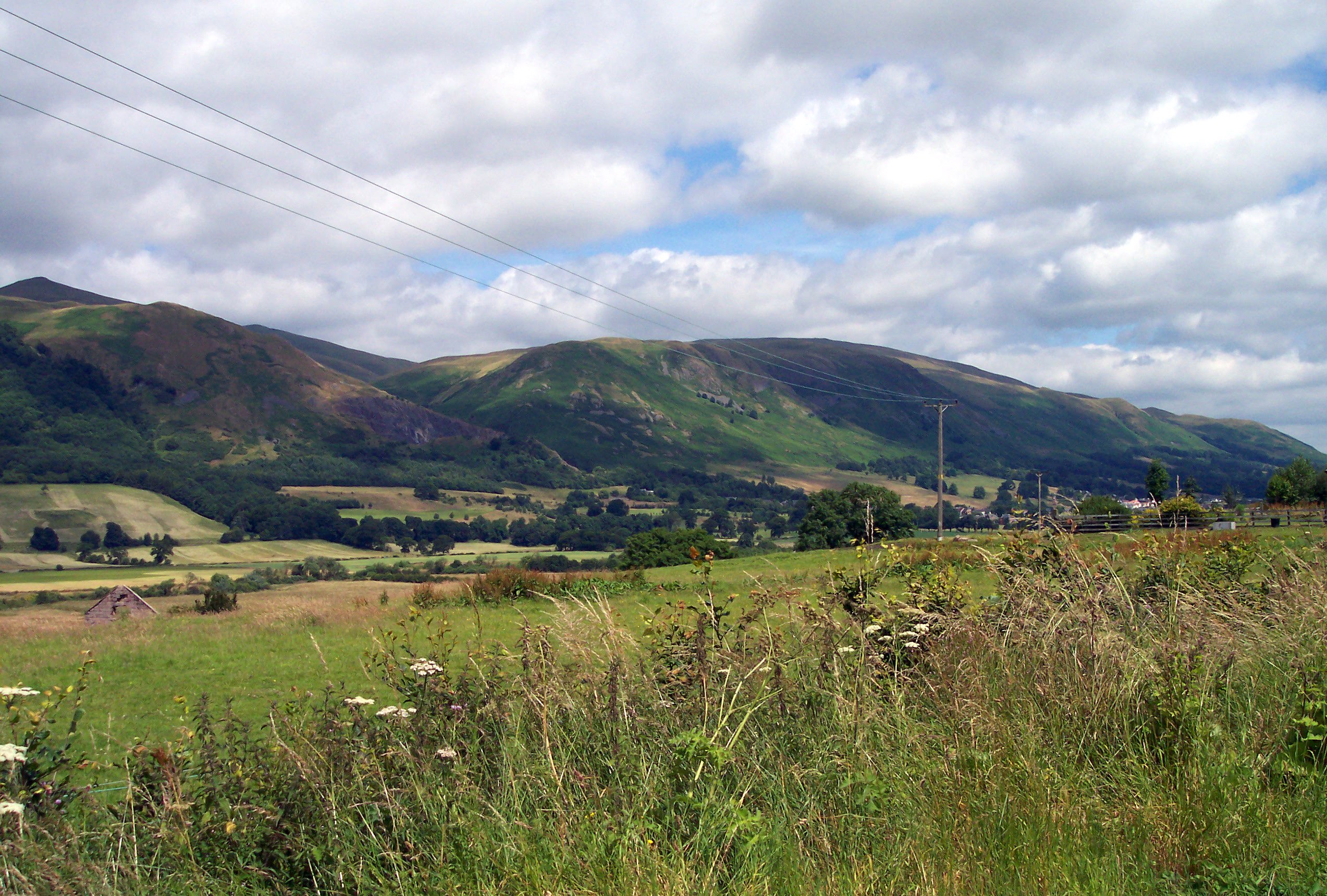
Auchlinsky Hill, located in Perthshire, Scotland, is a picturesque hill that offers stunning views and a peaceful atmosphere. Rising to an elevation of approximately 352 meters (1155 feet), it is classified as a hill rather than a mountain. The hill is situated in the southern part of Perthshire, near the village of Kinrossie.

Auchlinsky Hill is characterized by its gentle slopes and undulating terrain, covered in lush green vegetation. It is a popular spot for outdoor enthusiasts, hikers, and nature lovers who seek a tranquil escape amidst the beautiful Scottish countryside. The hill is easily accessible, with various footpaths and trails leading visitors to its summit.

At the top of Auchlinsky Hill, visitors are rewarded with breathtaking panoramic views of the surrounding countryside. On a clear day, one can see the rolling hills of Perthshire, the River Tay, and even glimpse the distant peaks of the Scottish Highlands. The hill offers a peaceful and serene setting, where visitors can enjoy a picnic or simply soak in the beauty of the natural surroundings.

Auchlinsky Hill is also known for its diverse flora and fauna. The hill is covered in heather, bracken, and scattered trees, providing a habitat for various bird species, including red grouse and skylarks. The area is also home to deer, rabbits, and other small mammals.

Overall, Auchlinsky Hill in Perthshire is a charming destination for those seeking a tranquil escape with stunning views. Whether it's for a leisurely hike or simply to enjoy the beauty of nature, this hill offers a serene and picturesque experience for all who visit.

If you have any feedback on the listing, please let us know in the comments section below.

Auchlinsky Hill Images

Images are sourced within 2km of 56.203653/-3.6341019 or Grid Reference NN9802. Thanks to Geograph Open Source API. All images are credited.

Castlehill Reservoir, Glen Devon
Hill fort, Down Hill Presumably Down is polite OS for Dùn/Doon? The small fort here has some well preserved walls and ramparts.
Hill fort, Down Hill
Presumably Down is polite OS for Dùn/Doon? The small fort here has some well preserved walls and ramparts.
Down Hill, summit Within the walls and ramparts of a hill fort. Steep slopes fall to Glen Devon.
Down Hill, summit
Within the walls and ramparts of a hill fort. Steep slopes fall to Glen Devon.
Glen Devon View from Down Hill showing the advance of the new native tree plantations. The walls and ramparts of the hill fort are in the foreground.
Glen Devon
View from Down Hill showing the advance of the new native tree plantations. The walls and ramparts of the hill fort are in the foreground.
Old milestone This granite milestone is at the complex junction at Yetts o' Muckhart of the A91 from west to east and the A823 from south to north.  As the years pass, the 18 painted on both faces in black is slowly fading away.  It is one of only two milestones that have been found in Clackmannanshire.   It is on HES Canmore 353389.
Old milestone
This granite milestone is at the complex junction at Yetts o' Muckhart of the A91 from west to east and the A823 from south to north. As the years pass, the 18 painted on both faces in black is slowly fading away. It is one of only two milestones that have been found in Clackmannanshire. It is on HES Canmore 353389.
A91 near Yetts o’ Muckhart
Location of OS Flush Bracket S5116
OS Flush Bracket S5116 - Muckhart, Church <span class="nowrap"><a title="https://www.bench-marks.org.uk/bm20788" rel="nofollow ugc noopener" href="https://www.bench-marks.org.uk/bm20788">Link</a><img style="margin-left:2px;" alt="External link" title="External link - shift click to open in new window" src="https://s1.geograph.org.uk/img/external.png" width="10" height="10"/></span>
OS Flush Bracket S5116 - Muckhart, Church
Cadgyer's Yett A pass on the old drove road above the Glenquey Burn.
Cadgyer's Yett
A pass on the old drove road above the Glenquey Burn.
Glenquey Reservoir A section of the old Dollar to Glen Devon drove road runs alongside the reservoir here.
Glenquey Reservoir
A section of the old Dollar to Glen Devon drove road runs alongside the reservoir here.
Scattered trees, Innerdownie The eastern flank of the hill has been planted with trees but isn't anywhere near as densely forested as the map would suggest.
Scattered trees, Innerdownie
The eastern flank of the hill has been planted with trees but isn't anywhere near as densely forested as the map would suggest.
View down Glenquey Hill
Pool of Muckhart Parish Church Viewed from the north-west.
Pool of Muckhart Parish Church
Viewed from the north-west.
Enclosed pathway along the edge of Pool of Muckhart Parish Church Cemetery Looking north-eastward.
Enclosed pathway along the edge of Pool of Muckhart Parish Church Cemetery
Looking north-eastward.
Footpath leading onto Seamab Hill Looking north-westward.
Footpath leading onto Seamab Hill
Looking north-westward.
Road (B934) near Upper Yetts Looking northward.
Road (B934) near Upper Yetts
Looking northward.
Ordnance Survey Flush Bracket S5116 This bracket can be found on the wall of the church at Pool of Muckhart. The benchmark height is recorded as being 165.33 metres above sea level. For more detail see : <span class="nowrap"><a title="http://www.bench-marks.org.uk/bm20788" rel="nofollow ugc noopener" href="http://www.bench-marks.org.uk/bm20788">Link</a><img style="margin-left:2px;" alt="External link" title="External link - shift click to open in new window" src="https://s1.geograph.org.uk/img/external.png" width="10" height="10"/></span>
Ordnance Survey Flush Bracket S5116
This bracket can be found on the wall of the church at Pool of Muckhart. The benchmark height is recorded as being 165.33 metres above sea level. For more detail see : LinkExternal link
Blacklinn Bridge, Glendevon The Blacklinn Bridge carries the A823, a cross-country road from the A822 (south of Crieff) to Dunfermline, across the River Devon at the head of Castlehill Reservoir. Opened in 1836, it is a Category B listed building. <span class="nowrap"><a title="https://www.britishlistedbuildings.co.uk/200344402-blacklinn-bridge-glendevon#.WgtoNzFLE5s" rel="nofollow ugc noopener" href="https://www.britishlistedbuildings.co.uk/200344402-blacklinn-bridge-glendevon#.WgtoNzFLE5s">Link</a><img style="margin-left:2px;" alt="External link" title="External link - shift click to open in new window" src="https://s1.geograph.org.uk/img/external.png" width="10" height="10"/></span>
Blacklinn Bridge, Glendevon
The Blacklinn Bridge carries the A823, a cross-country road from the A822 (south of Crieff) to Dunfermline, across the River Devon at the head of Castlehill Reservoir. Opened in 1836, it is a Category B listed building. LinkExternal link
Show me another place!

Auchlinsky Hill is located at Grid Ref: NN9802 (Lat: 56.203653, Lng: -3.6341019)

Unitary Authority: Perth and Kinross

Police Authority: Tayside

What 3 Words

///expansion.accordion.dweller. Near Dollar, Clackmannanshire

Nearby Locations

Glen Quey Auchlinsky Hill

Related Wikis

Roman Catholic Archdiocese of St Andrews and Edinburgh

The Archdiocese of Saint Andrews & Edinburgh (Latin: Archidioecesis Sancti Andreae et Edimburgensis) is an archdiocese of the Latin Church of the Catholic...

A823 road

The A823 is a road in Scotland which goes from south of Crieff to Dunfermline. It joins onto the A823(M) and the A822 which runs to Crieff.

Muckhart

Muckhart (Scottish Gaelic: Muc-Àird) commonly refers to two small villages in Clackmannanshire, Scotland, Pool of Muckhart (Scottish Gaelic: Poll Mhuc...
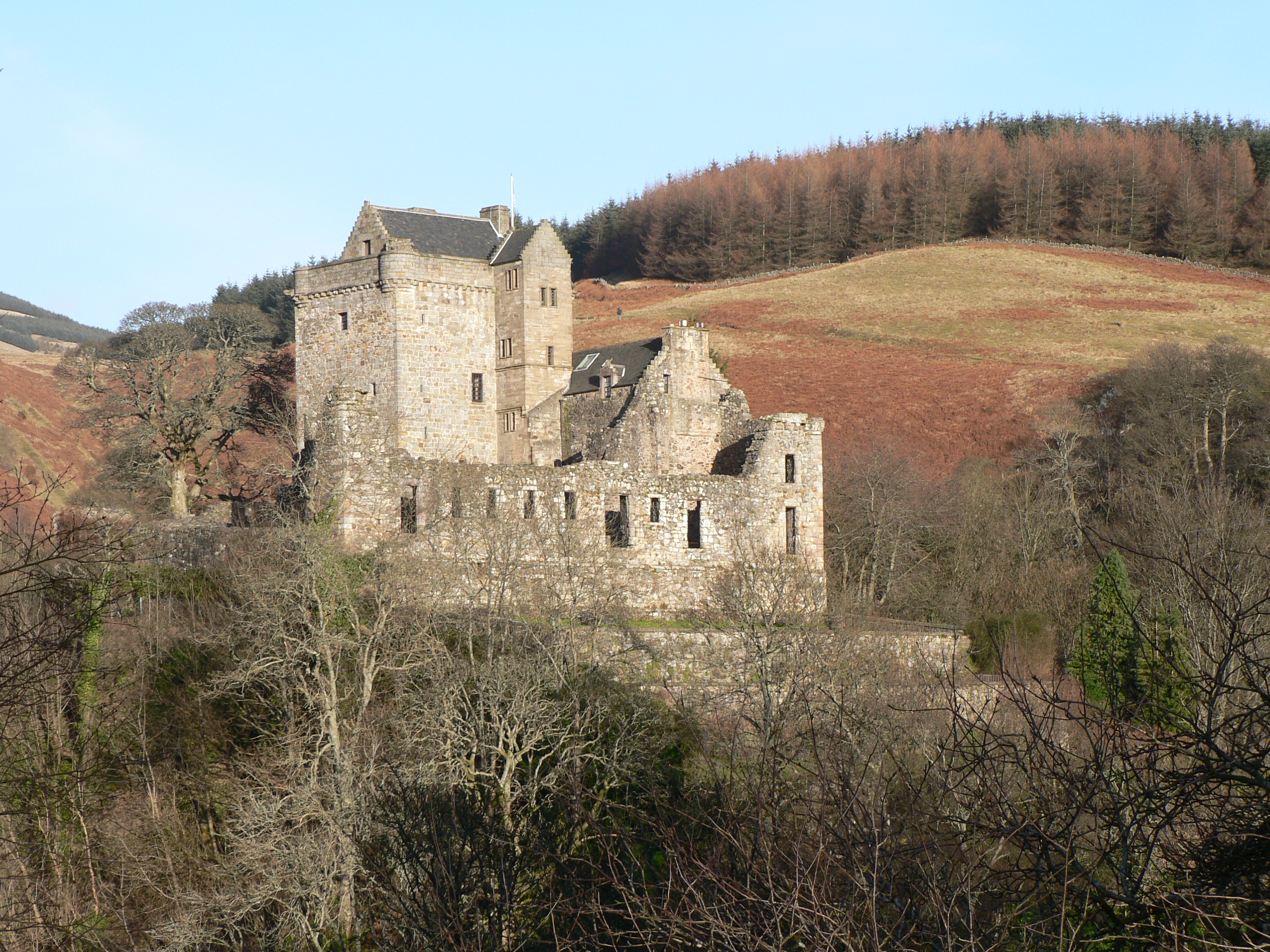
Glendevon Castle

Glendevon Castle is a collection of conjoined structures dating from the 15th century. The property is now (2022) semi-derelict. It lies on a private road...

Ochil Hills

The Ochil Hills ( ; Scottish Gaelic: Monadh Ochail is a range of hills in Scotland north of the Forth valley bordered by the towns of Stirling, Alloa,...

Strathdevon

Strathdevon is the strath of the River Devon in Clackmannanshire, Scotland. Strathdevon is associated with the parish of Muckhart and was up until 1971...

Cauldron Linn (River Devon)

Cauldron Linn, or Caldron Linn, is a waterfall on the River Devon on the border between Clackmannanshire and Perth and Kinross in Scotland. == Location... ==

Castle Campbell

Castle Campbell is a medieval castle situated above the town of Dollar, Clackmannanshire, in central Scotland. It was the lowland seat of the earls and...

Nearby Amenities

Located within 500m of 56.203653,-3.6341019
Auchlinsky Hill
Ele: 441
Natural: peak
Lat/Long: 56.2035057/-3.6343306
Barrier: stile
Material: wood
Stile: stepover
Lat/Long: 56.2057535/-3.6270917
The data included in this document is from www.openstreetmap.org. The data is made available under ODbL.

Have you been to Auchlinsky Hill?

Leave your review of Auchlinsky Hill below (or comments, questions and feedback).