Carn Mheadhoin

Hill, Mountain in Nairnshire

Scotland

Carn Mheadhoin

Ground descending towards Coire Odhar Mòr The foreground rock is part of a rib descending from the highest point of Cnapan a' Choire Odhair Bhig; it soon loses its identity, merging with the general slope on the way down to the shallow feature, Coire Odhar Mòr.
Ground descending towards Coire Odhar Mòr Credit: Trevor Littlewood

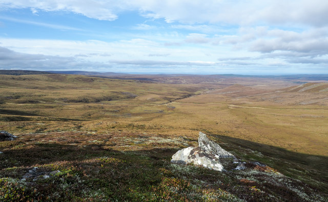
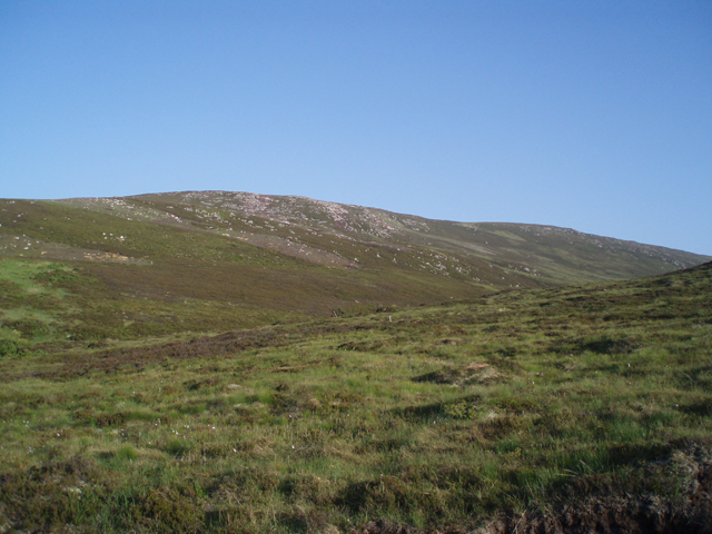
Carn Mheadhoin is a prominent hill located in Nairnshire, a historic county in the Highland region of Scotland. With an elevation of 379 meters (1,243 feet), it is considered a significant landmark in the area. The hill is situated in a rural and picturesque setting, surrounded by rolling countryside and offering breathtaking views of the surrounding landscape.

Carn Mheadhoin is characterized by its distinctive shape, with a rounded summit and gentle slopes. It is primarily composed of heather-covered moorland, with scattered areas of woodland. The hill provides a habitat for a variety of flora and fauna, including deer, birds, and other wildlife.

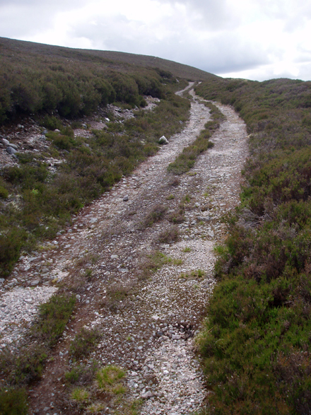
The hill is a popular destination for outdoor enthusiasts, who visit for activities such as hillwalking, hiking, and nature observation. There are several well-marked trails and footpaths that lead to the summit, offering different levels of difficulty to cater to all abilities.

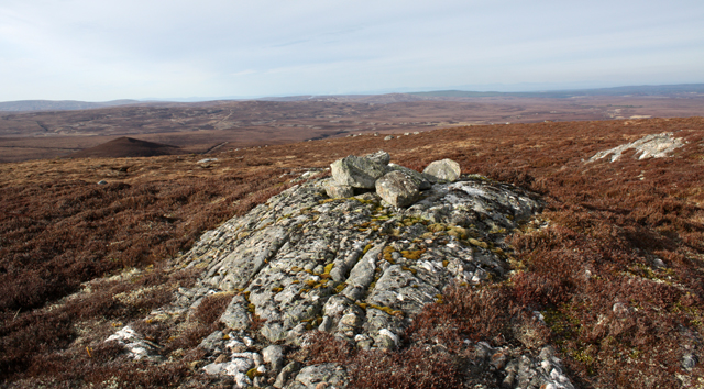
At the top of Carn Mheadhoin, visitors are rewarded with stunning panoramic views of the surrounding countryside, including the nearby town of Nairn, the Moray Firth, and the distant Cairngorms National Park. On clear days, it is even possible to spot the famous Ben Wyvis mountain to the west.

Carn Mheadhoin is not only a natural attraction but also a site of historical and cultural significance. It has been used as a landmark for centuries and holds a special place in the hearts of the local community. It continues to be cherished by visitors for its natural beauty, tranquility, and the sense of peace it offers to those who explore its slopes.

If you have any feedback on the listing, please let us know in the comments section below.

Carn Mheadhoin Images

Images are sourced within 2km of 57.350911/-3.8045101 or Grid Reference NH9130. Thanks to Geograph Open Source API. All images are credited.

Ground descending towards Coire Odhar Mòr The foreground rock is part of a rib descending from the highest point of Cnapan a' Choire Odhair Bhig; it soon loses its identity, merging with the general slope on the way down to the shallow feature, Coire Odhar Mòr.
Ground descending towards Coire Odhar Mòr
The foreground rock is part of a rib descending from the highest point of Cnapan a' Choire Odhair Bhig; it soon loses its identity, merging with the general slope on the way down to the shallow feature, Coire Odhar Mòr.
Looking SE from Leac an Daimh across Coire Odhar Mòr
Moorland Track High up on the track that crosses the northern flank of Carn Glas-choire and heads to the River Findhorn. In the distance Ben Rinnes can clearly be seen.
Moorland Track
High up on the track that crosses the northern flank of Carn Glas-choire and heads to the River Findhorn. In the distance Ben Rinnes can clearly be seen.
Slopes of Carn Allt Laoigh
Rounded rocks outcropping at a top of Creag na h-Iolaire Creag na h-Iolaire is part of the regime of the greater mountain, Carn Glas-choire; it has a number of rocky tops. Beinn Rinnes is the distant peak at the left side of the image; the Cromdale Hills are to the right.
Rounded rocks outcropping at a top of Creag na h-Iolaire
Creag na h-Iolaire is part of the regime of the greater mountain, Carn Glas-choire; it has a number of rocky tops. Beinn Rinnes is the distant peak at the left side of the image; the Cromdale Hills are to the right.
Perched boulders west of Cnapan a' Choire Odair Mhòir High ground connecting Carn Glas-choire with Creag na h-Iolaire passes over a point at 619m, west of Cnapan a' Choire Odair Mhòir; the boulders here are close to the 619m point. Distantly, to the south-east are the Cairngorms.
Perched boulders west of Cnapan a' Choire Odair Mhòir
High ground connecting Carn Glas-choire with Creag na h-Iolaire passes over a point at 619m, west of Cnapan a' Choire Odair Mhòir; the boulders here are close to the 619m point. Distantly, to the south-east are the Cairngorms.
Moors below Carn Glas Coire. Cawdor Estate's vast grouse moors beneath Carn Glas Coire (659m)
Moors below Carn Glas Coire.
Cawdor Estate's vast grouse moors beneath Carn Glas Coire (659m)
Glacial deposits, Auchtertipper Lochan trapped behind glacial sand mounds near the ruin of Auchtertipper.
Glacial deposits, Auchtertipper
Lochan trapped behind glacial sand mounds near the ruin of Auchtertipper.
Track in Coire Glas-choire Hill track on the west side of Tom nan Gabhar
Track in Coire Glas-choire
Hill track on the west side of Tom nan Gabhar
Duthil Burn Flowing through moorland north of Auchtertipper.  Snow has been thawing slowly enough not to cause any flooding lower down.
Duthil Burn
Flowing through moorland north of Auchtertipper. Snow has been thawing slowly enough not to cause any flooding lower down.
Frozen Lochan Unnamed lochan on moorland north of Auchtertipper.
Frozen Lochan
Unnamed lochan on moorland north of Auchtertipper.
Looking South along Duthil Burn On moorland north of Auchtertipper
Looking South along Duthil Burn
On moorland north of Auchtertipper
Rocky moorland on Creag na h-Iolaire This hill is a mass of rocky outcrops surrounded by boggy moorland. Looking across to Tom nan Gabhar.
Rocky moorland on Creag na h-Iolaire
This hill is a mass of rocky outcrops surrounded by boggy moorland. Looking across to Tom nan Gabhar.
Track on Creag na h-Iolaire Looking south towards the Cairngorms. A Cawdor estate track which goes to Drynachan from the Burn of Duthil.
Track on Creag na h-Iolaire
Looking south towards the Cairngorms. A Cawdor estate track which goes to Drynachan from the Burn of Duthil.
Track south of Cnapan a Choire Odhair Bhig Cawdor estate track from Duthil to Drynachan.
Track south of Cnapan a Choire Odhair Bhig
Cawdor estate track from Duthil to Drynachan.
Boggy ford, Allt Tarsuinn Two burns meet to form the Allt Tarsuinn, this is the northern one.
Boggy ford, Allt Tarsuinn
Two burns meet to form the Allt Tarsuinn, this is the northern one.
Cairn, Cnapan a Choire Odhair Bhig A few stones placed on a lump of rock at the highest point.
Cairn, Cnapan a Choire Odhair Bhig
A few stones placed on a lump of rock at the highest point.
Peat Hags west of Carn Allt Laoigh Looking across from Cnapan a Choire Odhair Bhig.
Peat Hags west of Carn Allt Laoigh
Looking across from Cnapan a Choire Odhair Bhig.
Show me another place!

Carn Mheadhoin is located at Grid Ref: NH9130 (Lat: 57.350911, Lng: -3.8045101)

Unitary Authority: Highland

Police Authority: Highlands and Islands

What 3 Words

///organisms.opera.desktop. Near Grantown-on-Spey, Highland

Nearby Locations

Carn Mheadhoin

Related Wikis

Diocese of Moray

The Diocese of Moray was one of the most important of the medieval dioceses of the Roman Catholic Church in Scotland. Its territory was in central northern...

Carn Glas-choire

Càrn Glas is a mountain with the Ardgoil Peninsula and the Arrochar Alps near Lochgoilhead. It reaches a height of over 502 metres (1,647 ft).

Badenoch and Strathspey

Badenoch and Strathspey is a former district of Highland region in Scotland. The district was created under the Local Government (Scotland) Act 1973 as...

Duthil

Duthil (Scottish Gaelic: Daothal) is a small village, bypassed by the A938 road, at the junction with the road B9007, near Carrbridge in Inverness-shire...

Have you been to Carn Mheadhoin?

Leave your review of Carn Mheadhoin below (or comments, questions and feedback).