Crooked Bank
Hill, Mountain in Lanarkshire
Scotland
Crooked Bank

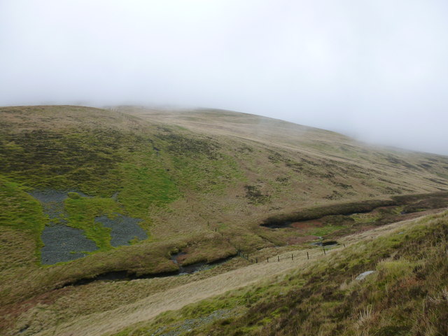
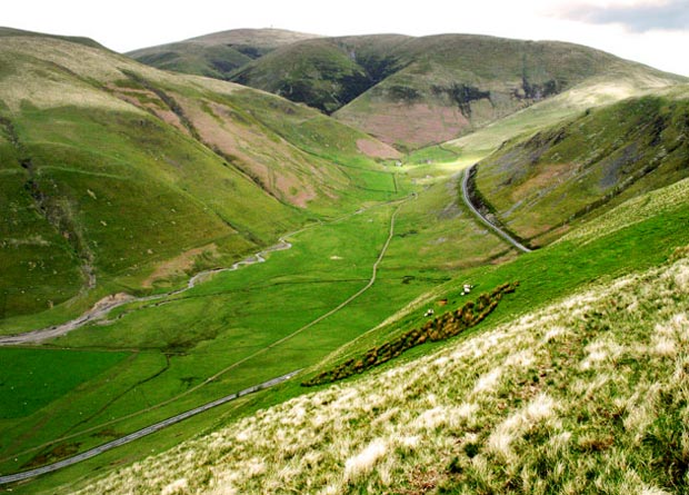
Crooked Bank, located in Lanarkshire, is a prominent hill/mountain that offers stunning panoramic views and is a popular destination for hikers, nature enthusiasts, and outdoor adventurers. Rising to an impressive height of approximately 500 meters, Crooked Bank stands tall amidst the picturesque landscape of Lanarkshire.
The hill/mountain derives its name from its unique and distinctive shape, resembling a crooked bank or ridge when viewed from a distance. Its irregular formation adds to the charm and allure of this natural wonder.
Crooked Bank is home to a diverse range of flora and fauna, making it an ideal spot for nature lovers. The area surrounding the hill/mountain is rich in biodiversity, with a variety of plant species flourishing in its fertile soil. Additionally, the hill/mountain provides a natural habitat for numerous animal species, including birds, small mammals, and insects.
The ascent to Crooked Bank is a challenging yet rewarding experience for hikers. Several trails and paths lead to the summit, offering different levels of difficulty suitable for both beginners and experienced climbers. Along the way, hikers are treated to breathtaking views of the surrounding countryside, including rolling hills, lush green valleys, and sparkling streams.
At the summit, visitors are rewarded with a breathtaking panorama that stretches as far as the eye can see. The awe-inspiring view encompasses the Lanarkshire countryside, neighboring hills, and distant landmarks. On clear days, one can even catch a glimpse of the majestic Scottish Highlands in the distance, adding to the grandeur of the scene.
In conclusion, Crooked Bank in Lanarkshire is a remarkable hill/mountain that offers a challenging yet unforgettable experience for outdoor enthusiasts. Its unique shape, diverse ecosystem, and stunning views make it a must-visit destination for those seeking to immerse themselves in the natural beauty of Scotland's countryside.
If you have any feedback on the listing, please let us know in the comments section below.
Crooked Bank Images
Images are sourced within 2km of 55.378467/-3.7267865 or Grid Reference NS9010. Thanks to Geograph Open Source API. All images are credited.


Crooked Bank is located at Grid Ref: NS9010 (Lat: 55.378467, Lng: -3.7267865)
Unitary Authority: South Lanarkshire
Police Authority: Lanarkshire
What 3 Words
///balconies.limit.guises. Near Sanquhar, Dumfries & Galloway
Nearby Locations
Related Wikis

Green Lowther
Green Lowther is a hill in the Lowther Hills range, part of the Southern Uplands of Scotland. It is the highest point of the Lowther Hills and lies in...
Lowther Hills
The Lowther Hills, also sometimes known as the Lowthers, are an extensive area of hill country in the Southern Uplands of Scotland, though some sub-ranges...

Wanlockhead railway station
Wanlockhead railway station was opened on 1 October 1902 as the terminus on the Leadhills and Wanlockhead Light Railway and served the lead mining area...

Wanlockhead
Wanlockhead is a village in Dumfries and Galloway, Scotland, nestling in the Lowther Hills and 1 mile (2 kilometres) south of Leadhills at the head of...
Nearby Amenities
Located within 500m of 55.378467,-3.7267865Have you been to Crooked Bank?
Leave your review of Crooked Bank below (or comments, questions and feedback).