East Morton Hill

Hill, Mountain in Dumfriesshire

Scotland

East Morton Hill

Track above The Shaw Some gnarled trees beside the track that branches off the main Kettleton Reservoir track and contours around Bellybought Hill and Par Hill.
Track above The Shaw Credit: Alan O'Dowd

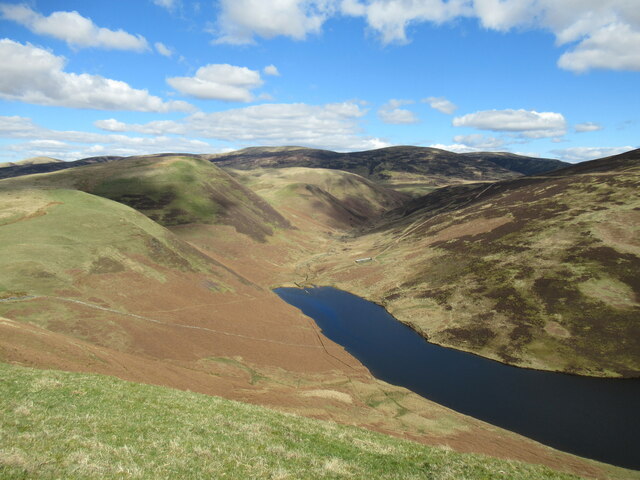
East Morton Hill is a prominent hill located in Dumfriesshire, Scotland. Standing at an elevation of 345 meters (1,132 feet), it offers stunning panoramic views of the surrounding countryside and the Solway Firth. The hill is a popular destination for hikers and nature enthusiasts, with a network of walking trails leading to the summit.

The hill is characterized by its rolling green slopes, dotted with patches of woodland and rocky outcrops. It is home to a variety of flora and fauna, including heather, gorse, and a diverse range of bird species.

East Morton Hill is steeped in history, with traces of ancient settlements and burial mounds dating back to the Bronze Age found on its slopes. The hill has also been used for centuries as a grazing ground for sheep and cattle.

Visitors to East Morton Hill can enjoy a peaceful and tranquil setting, perfect for picnicking, birdwatching, or simply taking in the natural beauty of the Scottish countryside. Whether you are a seasoned hiker or a casual nature lover, East Morton Hill offers a rewarding outdoor experience for all.

If you have any feedback on the listing, please let us know in the comments section below.

East Morton Hill Images

Images are sourced within 2km of 55.294811/-3.7365856 or Grid Reference NS8901. Thanks to Geograph Open Source API. All images are credited.

Track above The Shaw Some gnarled trees beside the track that branches off the main Kettleton Reservoir track and contours around Bellybought Hill and Par Hill.
Track above The Shaw
Some gnarled trees beside the track that branches off the main Kettleton Reservoir track and contours around Bellybought Hill and Par Hill.
Trig pillar and summit shelter, Bellybought Hill Unlike many hills in the Southern Uplands, there are quite a lot of (lichen-covered) stones on Bellybought Hill – enough for a fairly sizeable shelter.
Trig pillar and summit shelter, Bellybought Hill
Unlike many hills in the Southern Uplands, there are quite a lot of (lichen-covered) stones on Bellybought Hill – enough for a fairly sizeable shelter.
Looking across Carron Water Towards the Lowther Hills.
Looking across Carron Water
Towards the Lowther Hills.
Ankerdyne Cottage On the A702.
Ankerdyne Cottage
On the A702.
Jenny Hair's Bridge Over Carron Water on the road to Durisdeer.
Jenny Hair's Bridge
Over Carron Water on the road to Durisdeer.
Goldie Knoll Old hazelnut tree, Durisdeer hills in the distance, and daffodils at Goldie Knoll.
Photo taken on the 27th March, 2022.
Goldie Knoll
Old hazelnut tree, Durisdeer hills in the distance, and daffodils at Goldie Knoll. Photo taken on the 27th March, 2022.
New Ducks at Goldie Knoll New ducks on the pond at Goldie Knoll.
This photo was taken on the 16th September 2022.
New Ducks at Goldie Knoll
New ducks on the pond at Goldie Knoll. This photo was taken on the 16th September 2022.
Kettleton Reservoir from Bellybought Hill Kettleton Reservoir, seen here nestling below Morton Mains Hill and East Morton Hill, was created in the mid-twentieth century by damming the Kettleton Burn.
Kettleton Reservoir from Bellybought Hill
Kettleton Reservoir, seen here nestling below Morton Mains Hill and East Morton Hill, was created in the mid-twentieth century by damming the Kettleton Burn.
View towards the head of the Kettleton Burn The small peak-like hill in the middle distance is Sware Knowe.
View towards the head of the Kettleton Burn
The small peak-like hill in the middle distance is Sware Knowe.
The northern end of Kettleton Reservoir Kettleton Reservoir was created in the mid twentieth century by damming the Kettleton Burn. Part of a drystane dyke can be seen partially submerged in the water.
The northern end of Kettleton Reservoir
Kettleton Reservoir was created in the mid twentieth century by damming the Kettleton Burn. Part of a drystane dyke can be seen partially submerged in the water.
Clump of trees, The Hass The word 'hass' (sometimes 'hause' or 'hawse'), meaning 'neck', refers to a pass or col between hills. It refers here to this col between Morton Mains Hill and East Morton Hill.
Clump of trees, The Hass
The word 'hass' (sometimes 'hause' or 'hawse'), meaning 'neck', refers to a pass or col between hills. It refers here to this col between Morton Mains Hill and East Morton Hill.
The northern end of Kettleton Reservoir A view of the reservoir from Morton Mains Hill. The reservoir was created in the mid twentieth century by damming the Kettleton Burn.
The northern end of Kettleton Reservoir
A view of the reservoir from Morton Mains Hill. The reservoir was created in the mid twentieth century by damming the Kettleton Burn.
Ruined byre near Durisdeer Looking towards Nether Hill on the track leading into Glenaggart.
Ruined byre near Durisdeer
Looking towards Nether Hill on the track leading into Glenaggart.
View up Glenimp A small side valley off the Hapland Burn between Durisdeer and Glenaggart.
View up Glenimp
A small side valley off the Hapland Burn between Durisdeer and Glenaggart.
Track approaching Durisdeer Nearing the tiny village of Durisdeer on the track from Glenaggart.

A red kite can be seen gliding over the fields.
Track approaching Durisdeer
Nearing the tiny village of Durisdeer on the track from Glenaggart. A red kite can be seen gliding over the fields.
Goldie Knoll Goldie Knoll, with Morton Mains in the distance.
Goldie Knoll
Goldie Knoll, with Morton Mains in the distance.
Wee Waterfall at Goldie Knoll A wee waterfall on the Morton Gill near Goldie Knoll.
Wee Waterfall at Goldie Knoll
A wee waterfall on the Morton Gill near Goldie Knoll.
Show me another place!

East Morton Hill is located at Grid Ref: NS8901 (Lat: 55.294811, Lng: -3.7365856)

Unitary Authority: Dumfries and Galloway

Police Authority: Dumfries and Galloway

What 3 Words

///sunblock.lights.dwarf. Near Thornhill, Dumfries & Galloway

Related Wikis

Carronbridge railway station

Carronbridge railway station was a railway station in Dumfries and Galloway north of Dumfries, serving the village of Carronbridge and district. The station...

Morton Castle

Morton Castle is located by an artificial loch in the hills above Nithsdale, in Dumfries and Galloway, south-west Scotland. It lies 2.5 miles (4 km) north...

Durisdeer

Durisdeer is a small village in Dumfries and Galloway, south-west Scotland, and in the historic county of Dumfries-shire. It lies 6 miles (9.7 km) north...

Carronbridge

Carronbridge is a village in the parish of Morton in Dumfries and Galloway, Scotland. The village is at the junction of the A76 and A702 roads approximately...

Have you been to East Morton Hill?

Leave your review of East Morton Hill below (or comments, questions and feedback).