Achentoul Hill

Hill, Mountain in Sutherland

Scotland

Achentoul Hill

Heather and cotton grass by the Achentoul Burn The ascent to Knockfin Heights is through very dreary vegetation
Heather and cotton grass by the Achentoul Burn Credit: Mick Crawley

Achentoul Hill is a prominent hill located in the county of Sutherland, in the northernmost part of the Scottish Highlands. Rising to an elevation of 759 meters (2,490 feet), it is classified as a Corbett, which is a Scottish hill between 2,500 and 3,000 feet in height.

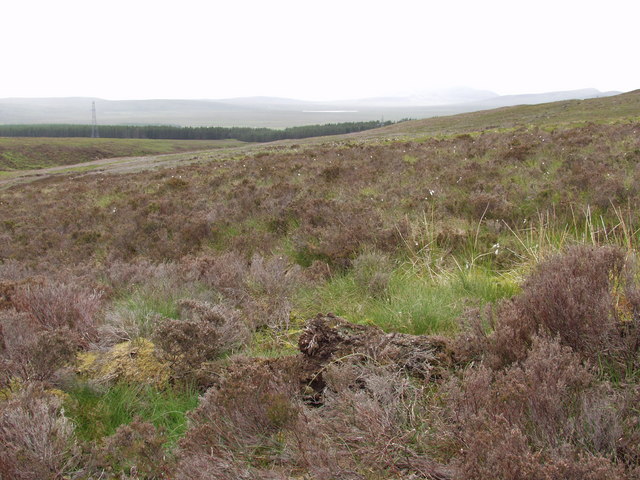
Situated near the village of Kinbrace, Achentoul Hill offers stunning panoramic views of the surrounding landscape, including the rugged peaks of the nearby Ben Klibreck mountain range. The hill is primarily composed of rocky terrain and heather moorland, with scattered patches of woodland in lower lying areas.

Achentoul Hill is a popular destination for outdoor enthusiasts, particularly hikers and hillwalkers. There are various routes to reach the summit, ranging in difficulty, but all offering rewarding views at the top. The ascent can be challenging due to the steep slopes and uneven ground, so a good level of fitness and appropriate hiking gear is recommended.

The hill is also home to a diverse range of wildlife, including red deer, mountain hares, and various bird species. Birdwatchers may have the opportunity to spot golden eagles soaring overhead or hear the distinctive calls of red grouse.

Achentoul Hill is part of the vast and untamed Scottish Highlands, attracting visitors with its raw beauty and tranquil atmosphere. Whether climbing to the summit or simply enjoying the surrounding countryside, this hill offers a memorable experience for nature lovers and outdoor enthusiasts alike.

If you have any feedback on the listing, please let us know in the comments section below.

Achentoul Hill Images

Images are sourced within 2km of 58.274258/-3.8871897 or Grid Reference NC8933. Thanks to Geograph Open Source API. All images are credited.

Heather and cotton grass by the Achentoul Burn The ascent to Knockfin Heights is through very dreary vegetation
Heather and cotton grass by the Achentoul Burn
The ascent to Knockfin Heights is through very dreary vegetation
Cnoc na Tuathrach burn The un-named stream drains the central part of Knockfin Heights
Cnoc na Tuathrach burn
The un-named stream drains the central part of Knockfin Heights
Western flank of Knockfin Heights Blanket bog with Rubus chamaemorus in the foreground, and the Ben Griams on the skyline (Ben Griam Mor on the left and Ben Griam Beg on the right) with Loch an Ruathair beneath them
Western flank of Knockfin Heights
Blanket bog with Rubus chamaemorus in the foreground, and the Ben Griams on the skyline (Ben Griam Mor on the left and Ben Griam Beg on the right) with Loch an Ruathair beneath them
Upper slopes of Knockfin Heights The transition from heather to blanket bog
Upper slopes of Knockfin Heights
The transition from heather to blanket bog
Blanket bog on Knockfin Heights Lochans in the background and cotton grass bog with Rubus chamaemorus (the big green leaves) in the foreground
Blanket bog on Knockfin Heights
Lochans in the background and cotton grass bog with Rubus chamaemorus (the big green leaves) in the foreground
Lochans on Knockfin Heights Some of the lochans support Menyanthes trifoliata (foreground) while others have Hippuris vulgaris.  It is the breeding birds for which the natural history of Knockfin Heights is most celebrated, with good populations of Dunlin, Greenshank and several Divers.
Lochans on Knockfin Heights
Some of the lochans support Menyanthes trifoliata (foreground) while others have Hippuris vulgaris. It is the breeding birds for which the natural history of Knockfin Heights is most celebrated, with good populations of Dunlin, Greenshank and several Divers.
Pools on SW of Knockfin Heights The high ground on the Heights is a mass of pools. In this area they were full of water. A greenshank was flying around here. Morven can be seen in the distance.
Pools on SW of Knockfin Heights
The high ground on the Heights is a mass of pools. In this area they were full of water. A greenshank was flying around here. Morven can be seen in the distance.
Large Pools on Knockfin Heights A greenshank was flying around here. The Griams can be seen in the distance.
Large Pools on Knockfin Heights
A greenshank was flying around here. The Griams can be seen in the distance.
Wooded gorge on Achentoul Burn Looking west (downstream) as the stream emerges from the steep-sided valley
Wooded gorge on Achentoul Burn
Looking west (downstream) as the stream emerges from the steep-sided valley
Achentoul waterfall Looking upstream towards the tiny (but charming) waterfall that heads the steep-sided section of the valley.
Achentoul waterfall
Looking upstream towards the tiny (but charming) waterfall that heads the steep-sided section of the valley.
The waterfall on Achentoul Burn The stream diverts around a rapidly eroding spur (on the right of the picture), ending in this mossy cascade into a peaty swimming hole
The waterfall on Achentoul Burn
The stream diverts around a rapidly eroding spur (on the right of the picture), ending in this mossy cascade into a peaty swimming hole
Achentoul Hill The view across wet heath towards the conifer shelterbelts around the farmstead at Achentoul.
Achentoul Hill
The view across wet heath towards the conifer shelterbelts around the farmstead at Achentoul.
Achentoul Burn The view south across recently-drained peat, past electricity pylons, to the rounded hill of Cnoc na Fliuch-airigh (325 m)
Achentoul Burn
The view south across recently-drained peat, past electricity pylons, to the rounded hill of Cnoc na Fliuch-airigh (325 m)
Achentoul Burn grasslands The improved grasslands that flank the burn inside the protective C-shaped shelterbelt. In the distance (left to right) Ben Graim Mor (590 m), Meall a'Bhuirich (407 m) and Ben Griam Beg (580 m).
Achentoul Burn grasslands
The improved grasslands that flank the burn inside the protective C-shaped shelterbelt. In the distance (left to right) Ben Graim Mor (590 m), Meall a'Bhuirich (407 m) and Ben Griam Beg (580 m).
Achentoul Shelterbelts The distinctive C-shaped shepterbelt that protects the inby ground at Achentoul
Achentoul Shelterbelts
The distinctive C-shaped shepterbelt that protects the inby ground at Achentoul
Pylon, Creag nan Caorach, Sutherland A extensive system of moorland drainage can be seen on the slope to the right of the pylon.
Pylon, Creag nan Caorach, Sutherland
A extensive system of moorland drainage can be seen on the slope to the right of the pylon.
The Allt Tom na Bràdh, Sutherland Looking towards Ben Griam Beg.

The name of the burn means Stream of the Knoll of the Quern.  It rises below Cnoc na Fliuch-airigh and flows down into Bannock Burn.
The Allt Tom na Bràdh, Sutherland
Looking towards Ben Griam Beg. The name of the burn means Stream of the Knoll of the Quern. It rises below Cnoc na Fliuch-airigh and flows down into Bannock Burn.
Ruined croft at Achentoul Rushy inbye grasslands contrast with the surrounding cotton-grass bog
Ruined croft at Achentoul
Rushy inbye grasslands contrast with the surrounding cotton-grass bog
Show me another place!

Achentoul Hill is located at Grid Ref: NC8933 (Lat: 58.274258, Lng: -3.8871897)

Unitary Authority: Highland

Police Authority: Highlands and Islands

What 3 Words

///elder.assemble.preheated. Near Kinbrace, Highland

Nearby Locations

Achentoul Hill Easan Geal

Related Wikis

Achentoul

Achentoul (Scottish Gaelic: Achadh an t-Sabhail; translation: "field of the barn") is a hamlet in the Kinbrace area of Sutherland, in the Scottish council...

Kinbrace

Kinbrace is a small village in Sutherland in the Highland council area of Scotland. It lies at the junction of the A897 and B871 and is 17 miles (27 km...

Kinbrace railway station

Kinbrace railway station is a railway station serving the village of Kinbrace in the Highland council area in the north of Scotland. It is located on the...

A897 road

The A897 single track road is entirely within the Highland council area of Scotland. It runs generally north from the A9 at Helmsdale to the A836 near...

Nearby Amenities

Located within 500m of 58.274258,-3.8871897
Achentoul Hill
Ele: 345
Natural: peak
Source: OS7
Lat/Long: 58.2740717/-3.8878705
The data included in this document is from www.openstreetmap.org. The data is made available under ODbL.

Have you been to Achentoul Hill?

Leave your review of Achentoul Hill below (or comments, questions and feedback).