Holywell Common

Settlement in Flintshire

Wales

Holywell Common

St Peter's Church, Holywell A modern, multi-purpose church building. The grid-line bisects the church and only the left-hand side of the building is in the square.
St Peter's Church, Holywell Credit: John H Darch

Holywell Common is a picturesque area located in Flintshire, Wales. Spanning approximately 19 hectares, it is a beautiful expanse of natural beauty that attracts both locals and tourists alike. The common is situated just outside the town of Holywell, making it easily accessible for visitors.

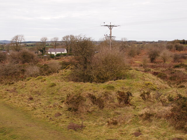
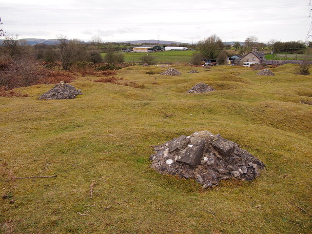
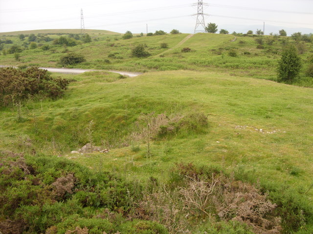
The landscape of Holywell Common is diverse and captivating. It features a mix of woodland areas, open grasslands, ponds, and wetlands, creating a haven for various plant and animal species. The common is known for its rich biodiversity, with a wide range of flora and fauna making it their home. Visitors can enjoy a leisurely stroll along the well-maintained paths, taking in the tranquil surroundings and immersing themselves in nature.

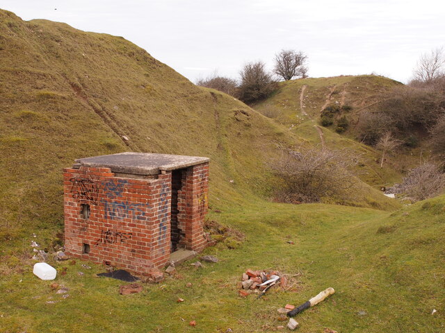
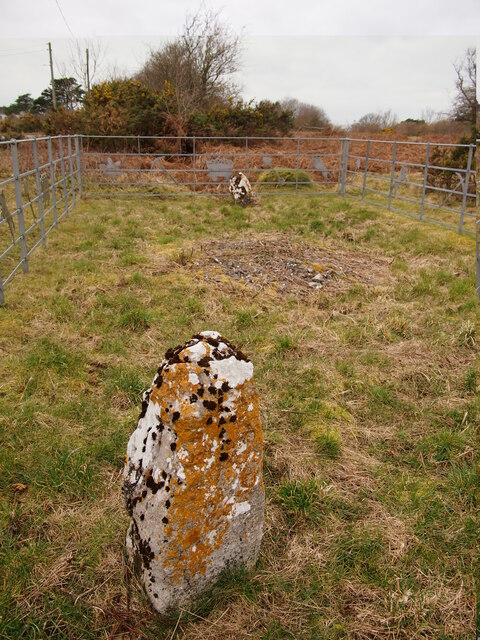
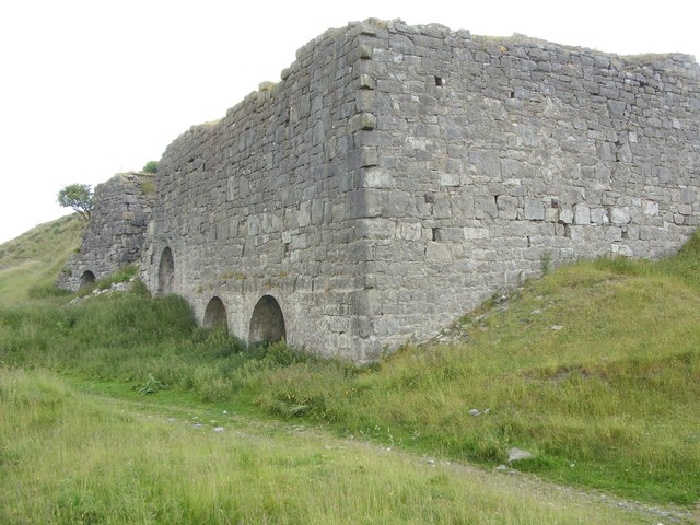
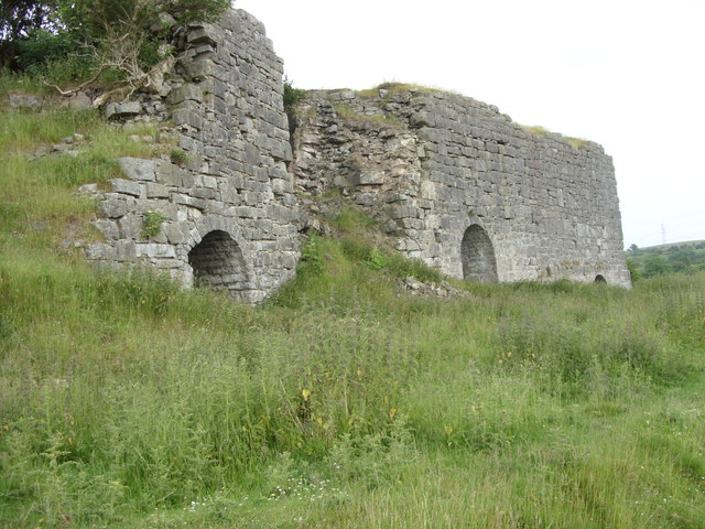
Aside from its natural beauty, Holywell Common also holds historical significance. It is believed to be the site of a medieval deer park, dating back to the 13th century. The remnants of an old deer enclosure can still be seen today, adding an air of historical charm to the area.

The common is a popular spot for outdoor activities such as picnicking, birdwatching, and photography. It also serves as a valuable educational resource, with guided nature walks and workshops organized throughout the year. The management of Holywell Common works tirelessly to protect and preserve this precious natural asset, ensuring its enjoyment for future generations.

Overall, Holywell Common is a hidden gem in Flintshire, offering a serene and enchanting escape from the hustle and bustle of everyday life. With its diverse landscapes, rich history, and abundant wildlife, it is a place that truly deserves to be explored and appreciated.

If you have any feedback on the listing, please let us know in the comments section below.

Holywell Common Images

Images are sourced within 2km of 53.256391/-3.228095 or Grid Reference SJ1873. Thanks to Geograph Open Source API. All images are credited.

St Peter's Church, Holywell A modern, multi-purpose church building. The grid-line bisects the church and only the left-hand side of the building is in the square.
St Peter's Church, Holywell
A modern, multi-purpose church building. The grid-line bisects the church and only the left-hand side of the building is in the square.
Old Shaft Bryn-Sannan
Disused Quarry Building, Pant y Pydew
Bryn Mawr Quarry
Bryn Mawr Quarry
Capped Shafts Near Waen-brodlas
The Disused Pen yr Henblas Quarry
Naid-y-March Standing Stones Possibly re-positioned Bronze Age stones, a filled mine shaft lies between them.
Naid-y-March Standing Stones
Possibly re-positioned Bronze Age stones, a filled mine shaft lies between them.
Ordnance Survey Cut Mark This OS cut mark can be found on the Town Hall, High Street. It marks a point 107.675m above mean sea level.
Ordnance Survey Cut Mark
This OS cut mark can be found on the Town Hall, High Street. It marks a point 107.675m above mean sea level.
Ordnance Survey Cut Mark This OS cut mark can be found on the old bank, High Street. It marks a point 109.746m above mean sea level.
Ordnance Survey Cut Mark
This OS cut mark can be found on the old bank, High Street. It marks a point 109.746m above mean sea level.
Ordnance Survey Cut Mark This OS cut mark can be found on the NW buttress of the school. It marks a point 372.23ft above mean sea level.
Ordnance Survey Cut Mark
This OS cut mark can be found on the NW buttress of the school. It marks a point 372.23ft above mean sea level.
Ordnance Survey Cut Mark This OS cut mark can be found on the old Court House, Halkyn Street. It marks a point 112.872m above mean sea level.
Ordnance Survey Cut Mark
This OS cut mark can be found on the old Court House, Halkyn Street. It marks a point 112.872m above mean sea level.
Ordnance Survey Rivet This OS rivet can be found on the step of No12 Coleshill Street. It marks a point 113.020m above mean sea level.
Ordnance Survey Rivet
This OS rivet can be found on the step of No12 Coleshill Street. It marks a point 113.020m above mean sea level.
Brynford cafe stop Cyclists on a Sunday morning ride prepare to leave the pet cemetery cafe where they'd stopped for morning coffee.
Brynford cafe stop
Cyclists on a Sunday morning ride prepare to leave the pet cemetery cafe where they'd stopped for morning coffee.
A55 eastbound near Calcoed
A55 eastbound near Milwr
Lead Mine shaft The hollow in the foreground is a run-in Lead Mine shaft. The flat grassed area behind it on the mound has a circular form indicating that there was a Horse Gin here, a horse-powered capstan for winding in the shaft. Although the wooden structure has long since gone the circular track the horse walked around is still visible. These show up well on aerial photographs.
Lead Mine shaft
The hollow in the foreground is a run-in Lead Mine shaft. The flat grassed area behind it on the mound has a circular form indicating that there was a Horse Gin here, a horse-powered capstan for winding in the shaft. Although the wooden structure has long since gone the circular track the horse walked around is still visible. These show up well on aerial photographs.
Limekilns at Pant y Pydew A massively built structure.
Limekilns at Pant y Pydew
A massively built structure.
Limekilns at Pant y Pydew
Show me another place!

Holywell Common is located at Grid Ref: SJ1873 (Lat: 53.256391, Lng: -3.228095)

Unitary Authority: Flintshire

Police Authority: North Wales

What 3 Words

///factually.driver.smooth. Near Holywell, Flintshire

Nearby Locations

Holywell Common Pwll-clai

Related Wikis

Brynford

Brynford (Welsh: Brynffordd) is a village and community in Flintshire, Wales. It is located to the south west of the town of Holywell and near the A55...

St Michael's Church, Brynford

St Michael's Church, also known as Brynford Parish Church, is a Grade II listed Church in Wales church in Brynford, Flintshire, northeast Wales, to the...

Calcoed

Calcoed is a small village in Flintshire, Wales. It is located to the south west of the town of Holywell, to the north west of the village of Brynford...

Holywell Golf Club

Holywell Golf Club (Welsh: Clwb Golff Treffynnon) is a golf club, situated a mile southwest of the town of Holywell, Flintshire, Wales. Instituted in...

Lluesty Hospital

Lluesty Hospital (Welsh: Ysbyty Lluesty) was a community hospital in Holywell, Flintshire, Wales. It was managed by the Betsi Cadwaladr University Health...

Holywell Workhouse Chapel

Holywell Workhouse Chapel was built in association with Holywell Workhouse in Old Chester Road, Holywell, Flintshire, Wales (grid reference SJ189750)....

Holywell Community Hospital

Holywell Community Hospital (Welsh: Ysbyty Cymuned Treffynnon) is a community hospital in Halkyn Road, Holywell, Flintshire, Wales. It is managed by the...

Holywell Town F.C.

Holywell Town Football Club (Welsh: Clwb PĂȘl-droed Treffynnon) is a Welsh football club from Holywell, Flintshire. They are nicknamed 'The Wellmen', and...

Nearby Amenities

Located within 500m of 53.256391,-3.228095
Power: pole
Lat/Long: 53.2555618/-3.2340509
Power: pole
Lat/Long: 53.25588/-3.2322236
Power: pole
Lat/Long: 53.2565371/-3.2305609
Power: pole
Lat/Long: 53.2583869/-3.2310664
Turning Circle
Lat/Long: 53.2578676/-3.2278834
Turning Circle
Lat/Long: 53.258721/-3.2338996
Power: pole
Lat/Long: 53.2538348/-3.2223136
Power: pole
Lat/Long: 53.2538167/-3.2247738
Power: pole
Lat/Long: 53.2538268/-3.2261086
Power: pole
Lat/Long: 53.2540734/-3.227261
Power: pole
Lat/Long: 53.2543387/-3.2284612
Power: pole
Lat/Long: 53.2546496/-3.2298868
Power: pole
Lat/Long: 53.2549731/-3.2313703
Power: pole
Lat/Long: 53.2551813/-3.2323436
Power: pole
Lat/Long: 53.2555664/-3.2335909
Power: pole
Lat/Long: 53.2553575/-3.2345377
Power: pole
Lat/Long: 53.2538243/-3.2235348
Grit Bin
Lat/Long: 53.2582388/-3.2330588
Bench
Lat/Long: 53.2584761/-3.2322181
Barrier: cattle_grid
Lat/Long: 53.2582422/-3.233788
Power: pole
Lat/Long: 53.2566577/-3.2295265
Power: pole
Lat/Long: 53.256781/-3.2285329
Power: pole
Lat/Long: 53.2573337/-3.2287532
Power: pole
Lat/Long: 53.2575561/-3.2292399
Power: pole
Lat/Long: 53.2575874/-3.2301117
Power: pole
Lat/Long: 53.2575766/-3.2298127
Power: pole
Lat/Long: 53.2575861/-3.2304604
Power: pole
Lat/Long: 53.2575789/-3.2309472
Power: pole
Lat/Long: 53.257972/-3.2310009
Power: pole
Lat/Long: 53.2569186/-3.2272243
Power: pole
Lat/Long: 53.257116/-3.2257706
Power: pole
Lat/Long: 53.2572909/-3.2242739
Power: pole
Lat/Long: 53.2573759/-3.2257518
Power: pole
Lat/Long: 53.2573631/-3.223767
Power: pole
Lat/Long: 53.2574666/-3.2231139
Power: pole
Lat/Long: 53.2573386/-3.2216904
Power: pole
Lat/Long: 53.2591843/-3.2317756
Power: pole
Lat/Long: 53.2594491/-3.2319151
Power: pole
Lat/Long: 53.2597363/-3.2320734
Power: pole
Lat/Long: 53.2591651/-3.2307671
Power: pole
Lat/Long: 53.2591426/-3.2297532
Power: pole
Lat/Long: 53.2564741/-3.2333874
Power: pole
Lat/Long: 53.2560119/-3.2325392
Bryn-Sannan
Place: hamlet
Lat/Long: 53.2596591/-3.2233644
Barrier: yes
Lat/Long: 53.2604936/-3.2289157
Millennium Milepost Brynford
Description: 1) Prestatyn 15 2) Flint 5.5, Y Fflint
Image: https://www.cyclestreets.net/location/197875/cyclestreets197875-size640.jpg
Information: guidepost
Ncn Milepost: mills
Sustrans Ref: MP 594
Tourism: information
Lat/Long: 53.2570571/-3.2212993
Direction: SSW
Generator Method: photovoltaic
Generator Output Electricity: yes
Generator Solar Modules: 16
Generator Source: solar
Generator Type: solar_photovoltaic_panel
Location: roof
Power: generator
Lat/Long: 53.2601168/-3.2268127
Direction: 190
Generator Method: photovoltaic
Generator Output Electricity: yes
Generator Solar Modules: 10
Generator Source: solar
Generator Type: solar_photovoltaic_panel
Location: roof
Power: generator
Lat/Long: 53.2597533/-3.2273706
Direction: 190
Generator Method: photovoltaic
Generator Output Electricity: yes
Generator Solar Modules: 6
Generator Source: solar
Generator Type: solar_photovoltaic_panel
Location: roof
Power: generator
Lat/Long: 53.2597686/-3.2275028
Direction: 125
Generator Method: photovoltaic
Generator Output Electricity: yes
Generator Solar Modules: 14
Generator Source: solar
Generator Type: solar_photovoltaic_panel
Location: roof
Power: generator
Lat/Long: 53.2589238/-3.2267437
Direction: ESE
Generator Method: photovoltaic
Generator Output Electricity: yes
Generator Solar Modules: 16
Generator Source: solar
Generator Type: solar_photovoltaic_panel
Location: roof
Power: generator
Lat/Long: 53.2593438/-3.2228035
Power: pole
Lat/Long: 53.2562086/-3.2313922
Power: pole
Lat/Long: 53.2560341/-3.2298841
Power: pole
Lat/Long: 53.2554927/-3.2292446
Power: pole
Lat/Long: 53.255525/-3.2286204
Power: pole
Lat/Long: 53.2555337/-3.2280435
Power: pole
Lat/Long: 53.2554558/-3.2299546
Power: pole
Lat/Long: 53.2553972/-3.2307457
Man Made: mineshaft
Lat/Long: 53.2573525/-3.2293827
Pwll-clai Lead Mines
Note: Multiple shafts and quarry pits, to mine the Pwll-clai Lead Vein
Place: locality
Lat/Long: 53.2544588/-3.2228304
Man Made: mineshaft
Lat/Long: 53.2560312/-3.2267479
Direction: ESE
Generator Method: photovoltaic
Generator Output Electricity: yes
Generator Solar Modules: 12
Generator Source: solar
Generator Type: solar_photovoltaic_panel
Location: roof
Power: generator
Lat/Long: 53.2606871/-3.2291061
Direction: 185
Generator Method: photovoltaic
Generator Output Electricity: yes
Generator Solar Modules: 6
Generator Source: solar
Generator Type: solar_photovoltaic_panel
Location: roof
Power: generator
Lat/Long: 53.2572579/-3.2297203
Direction: 185
Generator Method: photovoltaic
Generator Output Electricity: yes
Generator Solar Modules: 6
Generator Source: solar
Generator Type: solar_photovoltaic_panel
Location: roof
Power: generator
Lat/Long: 53.2572081/-3.2297324
Direction: 265
Generator Method: photovoltaic
Generator Output Electricity: yes
Generator Solar Modules: 14
Generator Source: solar
Generator Type: solar_photovoltaic_panel
Location: roof
Power: generator
Lat/Long: 53.2585732/-3.2319868
Direction: 265
Generator Method: photovoltaic
Generator Output Electricity: yes
Generator Solar Modules: 14
Generator Source: solar
Generator Type: solar_photovoltaic_panel
Location: roof
Power: generator
Lat/Long: 53.2584962/-3.2320122
Direction: 265
Generator Method: photovoltaic
Generator Output Electricity: yes
Generator Solar Modules: 14
Generator Source: solar
Generator Type: solar_photovoltaic_panel
Location: roof
Power: generator
Lat/Long: 53.2584135/-3.2320471
Direction: 265
Generator Method: photovoltaic
Generator Output Electricity: yes
Generator Solar Modules: 14
Generator Source: solar
Generator Type: solar_photovoltaic_panel
Location: roof
Power: generator
Lat/Long: 53.2583397/-3.2320766
Direction: 195
Generator Method: photovoltaic
Generator Output Electricity: yes
Generator Solar Modules: 14
Generator Source: solar
Generator Type: solar_photovoltaic_panel
Location: roof
Power: generator
Lat/Long: 53.2583008/-3.232664
Direction: 195
Generator Method: photovoltaic
Generator Output Electricity: yes
Generator Solar Modules: 14
Generator Source: solar
Generator Type: solar_photovoltaic_panel
Location: roof
Power: generator
Lat/Long: 53.2582828/-3.2325473
Direction: 195
Generator Method: photovoltaic
Generator Output Electricity: yes
Generator Solar Modules: 14
Generator Source: solar
Generator Type: solar_photovoltaic_panel
Location: roof
Power: generator
Lat/Long: 53.2582587/-3.2324166
Direction: 195
Generator Method: photovoltaic
Generator Output Electricity: yes
Generator Solar Modules: 14
Generator Source: solar
Generator Type: solar_photovoltaic_panel
Location: roof
Power: generator
Lat/Long: 53.258645/-3.2321014
Direction: 195
Generator Method: photovoltaic
Generator Output Electricity: yes
Generator Solar Modules: 14
Generator Source: solar
Generator Type: solar_photovoltaic_panel
Location: roof
Power: generator
Lat/Long: 53.2586658/-3.2322255
Direction: 195
Generator Method: photovoltaic
Generator Output Electricity: yes
Generator Solar Modules: 14
Generator Source: solar
Generator Type: solar_photovoltaic_panel
Location: roof
Power: generator
Lat/Long: 53.2586879/-3.2323435
Direction: 105
Generator Method: photovoltaic
Generator Output Electricity: yes
Generator Solar Modules: 14
Generator Source: solar
Generator Type: solar_photovoltaic_panel
Location: roof
Power: generator
Lat/Long: 53.2586646/-3.2325299
Direction: 105
Generator Method: photovoltaic
Generator Output Electricity: yes
Generator Solar Modules: 14
Generator Source: solar
Generator Type: solar_photovoltaic_panel
Location: roof
Power: generator
Lat/Long: 53.2589274/-3.2329765
Direction: 105
Generator Method: photovoltaic
Generator Output Electricity: yes
Generator Solar Modules: 14
Generator Source: solar
Generator Type: solar_photovoltaic_panel
Location: roof
Power: generator
Lat/Long: 53.258856/-3.23301
Direction: 105
Generator Method: photovoltaic
Generator Output Electricity: yes
Generator Solar Modules: 14
Generator Source: solar
Generator Type: solar_photovoltaic_panel
Location: roof
Power: generator
Lat/Long: 53.2587469/-3.233128
Direction: 105
Generator Method: photovoltaic
Generator Output Electricity: yes
Generator Solar Modules: 14
Generator Source: solar
Generator Type: solar_photovoltaic_panel
Location: roof
Power: generator
Lat/Long: 53.2586751/-3.2331689
Direction: 105
Generator Method: photovoltaic
Generator Output Electricity: yes
Generator Solar Modules: 14
Generator Source: solar
Generator Type: solar_photovoltaic_panel
Location: roof
Power: generator
Lat/Long: 53.2586017/-3.2332011
Direction: 105
Generator Method: photovoltaic
Generator Output Electricity: yes
Generator Solar Modules: 14
Generator Source: solar
Generator Type: solar_photovoltaic_panel
Location: roof
Power: generator
Lat/Long: 53.2585948/-3.2325755
Direction: 105
Generator Method: photovoltaic
Generator Output Electricity: yes
Generator Solar Modules: 14
Generator Source: solar
Generator Type: solar_photovoltaic_panel
Location: roof
Power: generator
Lat/Long: 53.2585267/-3.2326184
Direction: 105
Generator Method: photovoltaic
Generator Output Electricity: yes
Generator Solar Modules: 14
Generator Source: solar
Generator Type: solar_photovoltaic_panel
Location: roof
Power: generator
Lat/Long: 53.2584528/-3.2326694
Direction: 105
Generator Method: photovoltaic
Generator Output Electricity: yes
Generator Solar Modules: 14
Generator Source: solar
Generator Type: solar_photovoltaic_panel
Location: roof
Power: generator
Lat/Long: 53.2585323/-3.2332394
Direction: 105
Generator Method: photovoltaic
Generator Output Electricity: yes
Generator Solar Modules: 14
Generator Source: solar
Generator Type: solar_photovoltaic_panel
Location: roof
Power: generator
Lat/Long: 53.2584143/-3.2332957
Direction: 105
Generator Method: photovoltaic
Generator Output Electricity: yes
Generator Solar Modules: 14
Generator Source: solar
Generator Type: solar_photovoltaic_panel
Location: roof
Power: generator
Lat/Long: 53.2583449/-3.2333346
Direction: 125
Generator Method: photovoltaic
Generator Output Electricity: yes
Generator Solar Modules: 6
Generator Source: solar
Generator Type: solar_photovoltaic_panel
Location: roof
Power: generator
Lat/Long: 53.2588929/-3.226794
The data included in this document is from www.openstreetmap.org. The data is made available under ODbL.

Have you been to Holywell Common?

Leave your review of Holywell Common below (or comments, questions and feedback).