Reecleuch Hill

Hill, Mountain in Lanarkshire

Scotland

Reecleuch Hill

Old lead-mining tip below Lamb Knowes The traces of many small, long-abandoned lead mines can be found all over the hills in this area.
Old lead-mining tip below Lamb Knowes Credit: Alan O'Dowd

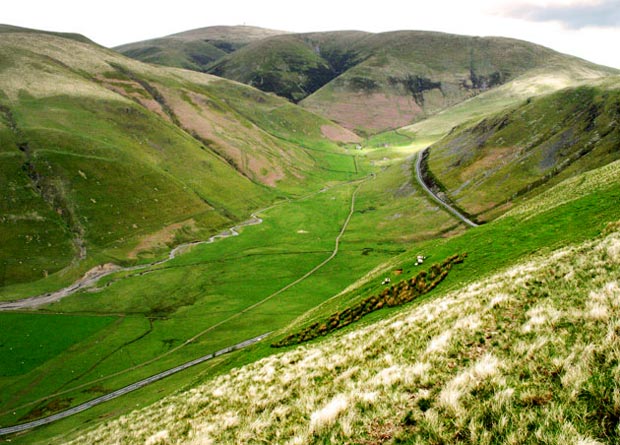
Reecleuch Hill, located in Lanarkshire, Scotland, is a prominent hill that stands at an elevation of 414 meters (1,358 feet). It is situated in the wider Southern Uplands range, which encompasses the border region between Scotland and England. Reecleuch Hill offers breathtaking views of the surrounding countryside, making it a popular destination for hikers and nature enthusiasts.

The hill itself is characterized by its gently sloping terrain and is covered in a mixture of grasses, heather, and shrubs. The summit provides a wide panorama of the Lanarkshire landscape, with distant views of the Clyde Valley and the Southern Highlands. On clear days, visitors can also spot the neighboring hills, such as Tinto Hill and Culter Fell.

Accessing Reecleuch Hill is relatively straightforward, with various routes available from nearby villages and towns. The hill is often included as part of longer walking routes, such as the Clyde Walkway or the Southern Upland Way, allowing visitors to incorporate it into their broader explorations of the area.

Aside from its natural beauty, Reecleuch Hill holds historical significance as well. The hill was once used as a meeting point for Covenanters, a group of Scottish Presbyterians who resisted religious persecution in the 17th century. Today, visitors can find remnants of the Covenanters' activities in the form of memorial cairns and stones scattered across the hill.

Overall, Reecleuch Hill is a picturesque and historically significant landmark in Lanarkshire, offering visitors a chance to immerse themselves in the region's natural beauty and rich heritage.

If you have any feedback on the listing, please let us know in the comments section below.

Reecleuch Hill Images

Images are sourced within 2km of 55.427735/-3.8099926 or Grid Reference NS8516. Thanks to Geograph Open Source API. All images are credited.

Old lead-mining tip below Lamb Knowes The traces of many small, long-abandoned lead mines can be found all over the hills in this area.
Old lead-mining tip below Lamb Knowes
The traces of many small, long-abandoned lead mines can be found all over the hills in this area.
Autumnal colours below Hunt Law Various deciduous grasses, which turn golden in autumn, can be seen on the ground here.
Autumnal colours below Hunt Law
Various deciduous grasses, which turn golden in autumn, can be seen on the ground here.
Meander on the Snar Water The Snar Water is a secondary tributary of the Clyde, rising on the hills above Leadhills and joining the Duneaton Water near Crawfordjohn.
Meander on the Snar Water
The Snar Water is a secondary tributary of the Clyde, rising on the hills above Leadhills and joining the Duneaton Water near Crawfordjohn.
Old sheepfold near Snarhead A disused and overgrown circular fold by the Snar Water.
Old sheepfold near Snarhead
A disused and overgrown circular fold by the Snar Water.
Lichen-covered rocks at old sheepfold A long-abandoned and overgrown circular fold just above the Snar Water.
Lichen-covered rocks at old sheepfold
A long-abandoned and overgrown circular fold just above the Snar Water.
Ford and footbridge approaching Duntercleuch The river is the Wanlock Water.
Ford and footbridge approaching Duntercleuch
The river is the Wanlock Water.
The house at Duntercleuch
Marker on the Kirkconnel Geological Trail This is also part of the route of the Southern Upland Way.
Marker on the Kirkconnel Geological Trail
This is also part of the route of the Southern Upland Way.
Snarhead Hill Looking towards the hilltop from the fence line on the southern slopes of the hill.
Snarhead Hill
Looking towards the hilltop from the fence line on the southern slopes of the hill.
Summit of Snarhead Hill Like many hills in the Southern Uplands a fence runs over it.The Lowther Hills can be seen in the distance.
Summit of Snarhead Hill
Like many hills in the Southern Uplands a fence runs over it.The Lowther Hills can be seen in the distance.
Reecleuch Hill View from the fence line running up the southern slopes of the hill.Grouse are abundant in this area of the moorland.
Reecleuch Hill
View from the fence line running up the southern slopes of the hill.Grouse are abundant in this area of the moorland.
Summit of Slough Hill Trig pillar on the hilltop.Tinto can be seen in the distance.
Summit of Slough Hill
Trig pillar on the hilltop.Tinto can be seen in the distance.
Ruins of lead smelter in the valley of the Wanlock Water Just a small part of the many mining remains in the area surrounding  Wanlockhead and Leadhills. The footbridge over the Wanlock Water can be seen this side of the works. Sowen Dodd <a href="https://www.geograph.org.uk/gridref/NS8614">NS8614</a> rises behind.
Ruins of lead smelter in the valley of the Wanlock Water
Just a small part of the many mining remains in the area surrounding Wanlockhead and Leadhills. The footbridge over the Wanlock Water can be seen this side of the works. Sowen Dodd NS8614 rises behind.
Looking down Wanlock Water from the footbridge Relics of the former leadmining industry can be seen in the floor of the valley.
Looking down Wanlock Water from the footbridge
Relics of the former leadmining industry can be seen in the floor of the valley.
Old lead smelter in the valley of the Wanlock Water Just a small part of the many mining remains in the area surrounding  Wanlockhead and Leadhills.
Old lead smelter in the valley of the Wanlock Water
Just a small part of the many mining remains in the area surrounding Wanlockhead and Leadhills.
Snar Water from the air Within the Lowther Hills, viewed from a Glasgow bound flight from Luton.
Snar Water from the air
Within the Lowther Hills, viewed from a Glasgow bound flight from Luton.
Ruined Cottage at Snarhead This ruinous shepherd's cottage at Snarhead, above the village of Leadhills in South Lanarkshire, now provides a home for wildlife.
Ruined Cottage at Snarhead
This ruinous shepherd's cottage at Snarhead, above the village of Leadhills in South Lanarkshire, now provides a home for wildlife.
Smelting Mill Remains Remains of smelting mill next to Southern Upland Way
Smelting Mill Remains
Remains of smelting mill next to Southern Upland Way
Show me another place!

Reecleuch Hill is located at Grid Ref: NS8516 (Lat: 55.427735, Lng: -3.8099926)

Unitary Authority: South Lanarkshire

Police Authority: Lanarkshire

What 3 Words

///beyond.shelving.users. Near Sanquhar, Dumfries & Galloway

Nearby Locations

Reecleuch Hill Ree Cleuch

Related Wikis

Leadhills

Leadhills, originally settled for the accommodation of miners, is a village in South Lanarkshire, Scotland, 5+3⁄4 miles (9.3 km) WSW of Elvanfoot. The...

Scots Mining Company House

The Scots Mining Company House, also known as Woodlands Hall, is an early-18th-century mansion house in Leadhills, South Lanarkshire, Scotland. The house...

Leadhills railway station

Leadhills railway station was opened on 1 October 1901 as the intermediate stop on the Leadhills and Wanlockhead Light Railway and served the lead mining...

Leadhills and Wanlockhead Railway

The Leadhills and Wanlockhead Railway is a 2 ft (610 mm) narrow gauge railway in South Lanarkshire, Scotland. It is laid on the trackbed of the former...

Wanlockhead

Wanlockhead is a village in Dumfries and Galloway, Scotland, nestling in the Lowther Hills and 1 mile (2 kilometres) south of Leadhills at the head of...

Wanlockhead railway station

Wanlockhead railway station was opened on 1 October 1902 as the terminus on the Leadhills and Wanlockhead Light Railway and served the lead mining area...

Lowther Hills

The Lowther Hills, also sometimes known as the Lowthers, are an extensive area of hill country in the Southern Uplands of Scotland, though some sub-ranges...

Whitecleuch Chain

The Whitecleuch Chain is a large Pictish silver chain that was found in Whitecleuch, Lanarkshire, Scotland in 1869. A high status piece, it is likely to...

Nearby Amenities

Located within 500m of 55.427735,-3.8099926
Reecleuch Hill
Ele: 432
Natural: peak
Lat/Long: 55.427696/-3.8100162
The data included in this document is from www.openstreetmap.org. The data is made available under ODbL.

Have you been to Reecleuch Hill?

Leave your review of Reecleuch Hill below (or comments, questions and feedback).