Ben Chonzie

Hill, Mountain in Perthshire

Scotland

Ben Chonzie

The south-west summit ridge of Ben Chonzie The prominent hill on the horizon, just right of centre, is the Loch Earn Ben Vorlich.
The south-west summit ridge of Ben Chonzie Credit: David Purchase

Ben Chonzie is a prominent hill in Scotland, located in the county of Perthshire. It stands at an elevation of 931 meters (3,054 feet) and is classified as a Corbett, which is a term used to describe a Scottish mountain between 2,500 and 3,000 feet high. The hill is situated approximately 16 kilometers northwest of Crieff, a popular town in Perthshire.

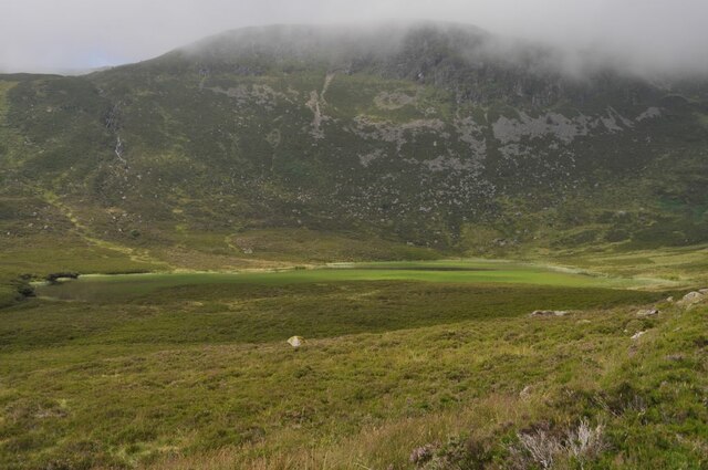
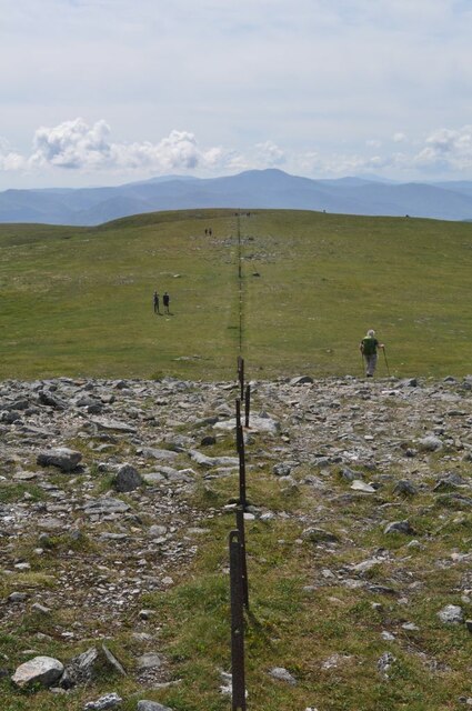
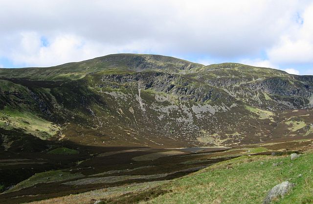
Ben Chonzie offers a relatively easy ascent, making it a popular destination for hikers and outdoor enthusiasts. The path to the summit starts in Glen Lednock and follows a well-defined track, gradually gaining elevation through open moorland and heather-covered slopes. The climb presents stunning panoramic views of the surrounding countryside, including the nearby Loch Turret Reservoir.

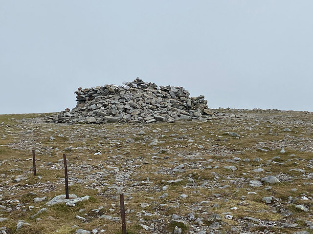
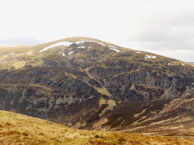
The hill is composed mainly of old red sandstone, giving it a distinctive reddish appearance. Its broad, rounded summit is characterized by a large cairn, which marks the highest point. On clear days, it is possible to see the Grampian Mountains to the north and even as far as Ben Nevis, the highest peak in the British Isles, to the northwest.

Ben Chonzie is also known for its abundant wildlife, with red grouse, mountain hares, and red deer commonly spotted in the area. The hill's accessibility and stunning views make it a popular choice for hillwalkers and a great introduction to the Scottish mountains.

If you have any feedback on the listing, please let us know in the comments section below.

Ben Chonzie Images

Images are sourced within 2km of 56.453956/-3.9920024 or Grid Reference NN7730. Thanks to Geograph Open Source API. All images are credited.

The south-west summit ridge of Ben Chonzie The prominent hill on the horizon, just right of centre, is the Loch Earn Ben Vorlich.
The south-west summit ridge of Ben Chonzie
The prominent hill on the horizon, just right of centre, is the Loch Earn Ben Vorlich.
The slopes of Ben Chonzie Meall na Seide, 757m, and Carn Chois, 786m, ahead, with Loch Turret below.
The slopes of Ben Chonzie
Meall na Seide, 757m, and Carn Chois, 786m, ahead, with Loch Turret below.
The end of the south-west ridge of Ben Chonzie Point 910m ahead, with the Loch Earn Ben Vorlich to the right.
The end of the south-west ridge of Ben Chonzie
Point 910m ahead, with the Loch Earn Ben Vorlich to the right.
Derelict grouse butts on Creag Dhubh an t-Sileidh
Approaching the summit of Ben Chonzie
Northwest slope from Ben Chonzie summit The large summit on the right is Creagan na Beinne. The smaller summit in the middle is Ciste Buide a' Claidheimh
Northwest slope from Ben Chonzie summit
The large summit on the right is Creagan na Beinne. The smaller summit in the middle is Ciste Buide a' Claidheimh
The smooth grassy slope on the north western side of Ben Chonzie
Shelter Cairn, Ben Chonzie summit A substantial shelter on the 931m Munro summit.
Shelter Cairn, Ben Chonzie summit
A substantial shelter on the 931m Munro summit.
The broad ridge of Ben Chonzie Approaching the summit of the hill.
The broad ridge of Ben Chonzie
Approaching the summit of the hill.
Sheep on the summit ridge of Ben Chonzie
Lochan Uaine Lochan Uaine here is almost completely covered in plants and green algae
Lochan Uaine
Lochan Uaine here is almost completely covered in plants and green algae
Concrete Slab in Glen Turret The long track in from the head of Loch Turret ends at this concrete slab, origin unknown.
Concrete Slab in Glen Turret
The long track in from the head of Loch Turret ends at this concrete slab, origin unknown.
Miniature Lochan Not shown on any maps; this small pool in Bealach na Gaoith between Ben Chonzie and Biorach a' Mheannain will probably disappear with a good spell of dry weather.
Miniature Lochan
Not shown on any maps; this small pool in Bealach na Gaoith between Ben Chonzie and Biorach a' Mheannain will probably disappear with a good spell of dry weather.
Ben Chonzie Summit Ben Chonzie is a form of Beinn a' Chòinnich, the mossy mountain, and is shown as such on at least one OS one-inch map, albeit rendered as Beinn a' Chonnaich.
Ben Chonzie Summit
Ben Chonzie is a form of Beinn a' Chòinnich, the mossy mountain, and is shown as such on at least one OS one-inch map, albeit rendered as Beinn a' Chonnaich.
A Sense of Symmetry Man's desire to fence off his property extends even to the top of Munros.
A Sense of Symmetry
Man's desire to fence off his property extends even to the top of Munros.
Grouse butts on Ben Chonzie's north flank These stone shooting butts are simple windbreaks, not the more elaborate curved shelters. Several of them are spaced regularly along Ben Chonzie's north flank. One more lies behind the photographer.
Grouse butts on Ben Chonzie's north flank
These stone shooting butts are simple windbreaks, not the more elaborate curved shelters. Several of them are spaced regularly along Ben Chonzie's north flank. One more lies behind the photographer.
Broken Posts Once these posts are reached there is no longer any need to check your map or phone - they lead straight to the summit of Ben Chonzie, one of the most accessible Munros for the majority of the Scottish population.
Most of them, though, are former posts, seemingly sliced off near the ground for no obvious reason - there are a number of the top bits lying around nearby. A handful have remained intact, but mostly they are metal stumps like these, with a few occasionally bent over to such an extent that their top ends are now just a few inches above the ground. All in all, very perplexing!
Broken Posts
Once these posts are reached there is no longer any need to check your map or phone - they lead straight to the summit of Ben Chonzie, one of the most accessible Munros for the majority of the Scottish population. Most of them, though, are former posts, seemingly sliced off near the ground for no obvious reason - there are a number of the top bits lying around nearby. A handful have remained intact, but mostly they are metal stumps like these, with a few occasionally bent over to such an extent that their top ends are now just a few inches above the ground. All in all, very perplexing!
East side of Ben Chonzie Unlike the hill that I was on, there was a steady stream of appearances of people beside the summit of Ben Chonzie. This is the steep face above the head of Glen Turret.
East side of Ben Chonzie
Unlike the hill that I was on, there was a steady stream of appearances of people beside the summit of Ben Chonzie. This is the steep face above the head of Glen Turret.
Show me another place!

Ben Chonzie is located at Grid Ref: NN7730 (Lat: 56.453956, Lng: -3.9920024)

Unitary Authority: Perth and Kinross

Police Authority: Tayside

What 3 Words

///vaulting.investors.unsettled. Near Comrie, Perth & Kinross

Nearby Locations

Ben Chonzie

Related Wikis

Ben Chonzie

Ben Chonzie or Ben-y-Hone (Scottish Gaelic: Beinn a' Chomhainn, 'mountain of the narrowness', or possibly from Beinn Chòinnich, 'mossy mountain') is a...
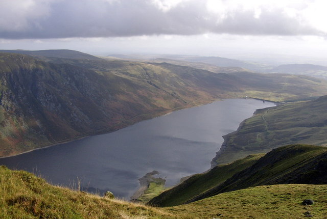
Loch Turret

Loch Turret is a large freshwater reservoir on a north-east to south-west orientation, that is located at the head of Glen Turret and 5.39 miles (8.67...

Perthshire

Perthshire (locally: ; Scottish Gaelic: Siorrachd Pheairt), officially the County of Perth, is a historic county and registration county in central Scotland...

Stirling (council area)

The Stirling council area (Scots: Stirlin; Scottish Gaelic: Sruighlea) is one of the 32 council areas of Scotland, and has a population of about 93,470...

Nearby Amenities

Located within 500m of 56.453956,-3.9920024
Ben Chonzie
Alt Name: Ben-y Hone
Description: Mountain of the moss
Ele: 931
Marilyn: yes
Munro: yes
Munro Number: M250
Name Ar: جبل بين تشونزى
Name Cy: Ben Chonzie
Name De: Ben Chonzie
Name En: Ben Chonzie
Name Gd: Beinn a' Chòinnich
Name Nl: Ben Chonzie
Name Sv: Ben Chonzie
Natural: peak
Prominence: 645
Wikidata: Q3397984
Wikipedia: en:Ben Chonzie
Lat/Long: 56.4538846/-3.9920844
The data included in this document is from www.openstreetmap.org. The data is made available under ODbL.

Have you been to Ben Chonzie?

Leave your review of Ben Chonzie below (or comments, questions and feedback).