Bengairn

Hill, Mountain in Kirkcudbrightshire

Scotland

Bengairn

Bengairn A rough hill seen from the Torr peninsula.
Bengairn Credit: Richard Webb

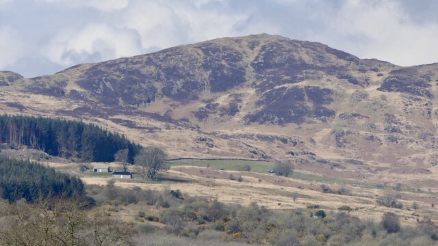
Bengairn is a prominent hill located in Kirkcudbrightshire, Scotland. Standing at a height of 562 meters (1,844 feet), it offers stunning panoramic views of the surrounding countryside and coastline. The hill is part of the Galloway Hills and is a popular destination for hikers and outdoor enthusiasts.

Bengairn is characterized by its rugged terrain and rocky slopes, making it a challenging but rewarding climb for experienced hikers. The hill is home to a variety of flora and fauna, including heather, bracken, and birds of prey such as buzzards and kestrels.

The summit of Bengairn is marked by a cairn, where hikers can take a well-deserved rest and soak in the breathtaking views of the rolling hills and valleys below. On a clear day, it is possible to see all the way to the Solway Firth and even as far as the Isle of Man.

Overall, Bengairn is a picturesque and invigorating hill that offers a true taste of the natural beauty and rugged landscape of Kirkcudbrightshire.

If you have any feedback on the listing, please let us know in the comments section below.

Bengairn Images

Images are sourced within 2km of 54.870239/-3.9173115 or Grid Reference NX7754. Thanks to Geograph Open Source API. All images are credited.

Bengairn A rough hill seen from the Torr peninsula.
Bengairn
A rough hill seen from the Torr peninsula.
Sunset over Bengairn & Screel
Path along the ridge of Screel hill. The summit lies ahead.
Path along the ridge of Screel hill.
The summit lies ahead.
The summit of Screel hill. A large cairn adorns the top.
The summit of Screel hill.
A large cairn adorns the top.
Track below Screel hill. View towards the coast.
Track below Screel hill.
View towards the coast.
From Screel View from the east summit of Screel, looking south east over the Solway to England; the island is Hestan (NX8350), where Edward Balliol had his base when he was pretender to the throne of Scotland in the 1320s. The apparent lochan on the west side of Torr Point isn't really there - the field was flooded.
From Screel
View from the east summit of Screel, looking south east over the Solway to England; the island is Hestan (NX8350), where Edward Balliol had his base when he was pretender to the throne of Scotland in the 1320s. The apparent lochan on the west side of Torr Point isn't really there - the field was flooded.
Ruined farm buildings at Forest Hill The track to Bengairn peters out just past Forest Hill.
Ruined farm buildings at Forest Hill
The track to Bengairn peters out just past Forest Hill.
Another photo of the ruins at Forest Hill
Summit of Bengairn
Summit of Bengairn
Screel Hill Summit Cairn Looking from Screel Hill Summit NNW. Castle Douglas and Carlingwark Loch visible in middle distance on right of shot.
Screel Hill Summit Cairn
Looking from Screel Hill Summit NNW. Castle Douglas and Carlingwark Loch visible in middle distance on right of shot.
Forest Track, Screel Hill The Forest Track south of Screel Hill, with the Solway Firth in the distance, Castle Point on the left, Almorness Point centre, and Hestan Island to the right of the picture.
Forest Track, Screel Hill
The Forest Track south of Screel Hill, with the Solway Firth in the distance, Castle Point on the left, Almorness Point centre, and Hestan Island to the right of the picture.
Glenhead, Auchencairn View northwest along track to Glenhead Farm. In the distance is Hass Farm nestling under Dungarry and Bentudor hills.
Glenhead, Auchencairn
View northwest along track to Glenhead Farm. In the distance is Hass Farm nestling under Dungarry and Bentudor hills.
View from Screel Hill Looking down to the forestry beneath Screel Hill with Auchencairn Bay in the distance.
View from Screel Hill
Looking down to the forestry beneath Screel Hill with Auchencairn Bay in the distance.
Screel Hill From Taliesin Community Woodland
Screel Hill
From Taliesin Community Woodland
Screel Hill Screel from the top of North Glen, with Potterland Farm in the middle distance
Screel Hill
Screel from the top of North Glen, with Potterland Farm in the middle distance
Ben Tudor, Bengairn, Midhill, and Screel (left to right) The range of hills as seen from above Gibbs Hole Wood on Almorness peninsula.  At the left hand end of the range is the impressive Dungarry hill fort (NX 757 535)
Ben Tudor, Bengairn, Midhill, and Screel (left to right)
The range of hills as seen from above Gibbs Hole Wood on Almorness peninsula. At the left hand end of the range is the impressive Dungarry hill fort (NX 757 535)
Wild Primulas in brash
Bengairn View from the summit of Screel Hill.
Bengairn
View from the summit of Screel Hill.
Show me another place!

Bengairn is located at Grid Ref: NX7754 (Lat: 54.870239, Lng: -3.9173115)

Unitary Authority: Dumfries and Galloway

Police Authority: Dumfries and Galloway

What 3 Words

///clustered.encoding.both. Near Castle Douglas, Dumfries & Galloway

Nearby Locations

Mid Hill Bengairn

Related Wikis

Airieland

Airieland is a farm in the historical county of Kirkcudbrightshire, in the Scottish council area of Dumfries and Galloway. It is found 3 miles (5 km) south...

Gelston Castle

Gelston Castle, located near Castle Douglas in Kirkcudbrightshire in Dumfries and Galloway, Scotland, was built by Sir William Douglas of Castle Douglas...

Orchardton Castle

Orchardton Castle overlooks the Solway Coast. Built in the 1880s, this is a Grade B listed property formerly known as Orchardton House. Built around a...

Auchencairn

Auchencairn ([ɔxən'kʰɛ:(r)n]) is a village in the historical county of Kirkcudbrightshire in the Dumfries and Galloway region of Scotland. It is located...

Related Videos

Trees Down and Lost In the Woods on Screel Hill in Scotland

A fabulous hike up Screel Hill close to the sea in Dumfries and Galloway Play Bingo to see how many times I say 'Screel Hill' in ...

Screel Hill, DJI Mavic 2 Pro 4K video footage

Screel Hill in Dumfries and Galloway, south west Scotland. A popular location for walking and for the more energetic, running.

Nearby Amenities

Located within 500m of 54.870239,-3.9173115
Bengairn
Ele: 391
Natural: peak
Lat/Long: 54.8702381/-3.9173783
Note: There's an easy way across an electric fence rond here
Lat/Long: 54.8733857/-3.9170632
Ele: 391
Man Made: survey_point
Ref: S8424
Lat/Long: 54.8702386/-3.9173298
Man Made: cairn
Lat/Long: 54.8702807/-3.9174629
The data included in this document is from www.openstreetmap.org. The data is made available under ODbL.

Have you been to Bengairn?

Leave your review of Bengairn below (or comments, questions and feedback).