Creagan Dubha Rèidhe Bhig

Hill, Mountain in Sutherland

Scotland

Creagan Dubha Rèidhe Bhig

A Tributary of Allt Lon a Chuil A small burn.
A Tributary of Allt Lon a Chuil Credit: david glass

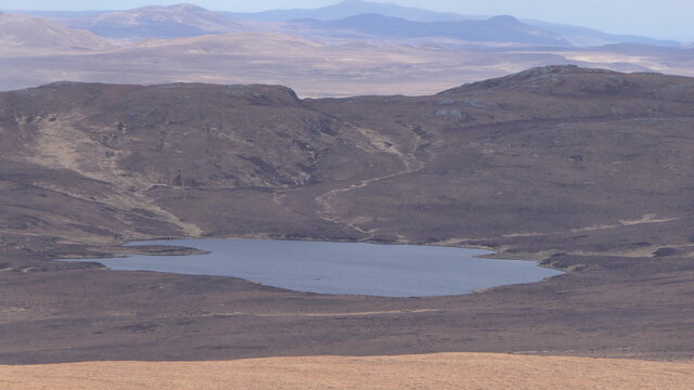
Creagan Dubha Rèidhe Bhig is a small hill located in the beautiful region of Sutherland, Scotland. Standing at an elevation of approximately 300 meters, it offers breathtaking views of the surrounding landscape.

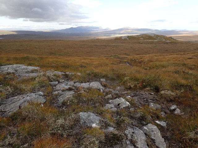
The hill is known for its rugged and rocky terrain, with numerous crevices and boulders scattered across its slopes. Its name, Creagan Dubha Rèidhe Bhig, translates to "little black and red crags" in Gaelic, which accurately describes the distinct colors and textures of the rocks found here.

The vegetation on the hill is mostly heather, which adds a vibrant purple hue to the landscape during the blooming season. The hill is also home to various species of birds, including eagles, kestrels, and ptarmigans, making it a popular spot for birdwatchers.

Hikers and outdoor enthusiasts are drawn to Creagan Dubha Rèidhe Bhig due to its accessible trails and the panoramic views it offers. The ascent to the summit is moderate, providing a satisfying challenge for those seeking a bit of adventure.

From the top, visitors can enjoy a sweeping vista of the surrounding countryside, with distant mountains, lochs, and the North Sea visible on clear days. The hill's location in the remote and untouched wilderness of Sutherland adds to its allure, providing a true sense of tranquility and escape from the hustle and bustle of everyday life.

Overall, Creagan Dubha Rèidhe Bhig is a remarkable hill in Sutherland that captivates visitors with its rugged beauty, diverse wildlife, and stunning vistas.

If you have any feedback on the listing, please let us know in the comments section below.

Creagan Dubha Rèidhe Bhig Images

Images are sourced within 2km of 58.36723/-4.1352431 or Grid Reference NC7544. Thanks to Geograph Open Source API. All images are credited.

A Tributary of Allt Lon a Chuil A small burn.
A Tributary of Allt Lon a Chuil
A small burn.
Moorland in the Catchment of Allt Lon a Chuil A peat-filled basin in the catchment of the Allt Lon a Chuil.
Moorland in the Catchment of Allt Lon a Chuil
A peat-filled basin in the catchment of the Allt Lon a Chuil.
Lochan Sgeireach
Lochan Sgeireach
Empty Moorland above Rimsdale There was a lot of bog myrtle around here, in amongst the clumps of grass and heather. Cnoc Bothan Uisge-beatha can just be seen in the distance.
Empty Moorland above Rimsdale
There was a lot of bog myrtle around here, in amongst the clumps of grass and heather. Cnoc Bothan Uisge-beatha can just be seen in the distance.
Beginning of Tributary of Rimsdale Burn There was a lot of cross-leaved heath in this grassy area, showing perhaps that the area is generally drier than the land below.
Beginning of Tributary of Rimsdale Burn
There was a lot of cross-leaved heath in this grassy area, showing perhaps that the area is generally drier than the land below.
Lochan Sgeireach Seen in early morning sunshine, from a rocky outcrop.
Lochan Sgeireach
Seen in early morning sunshine, from a rocky outcrop.
Rocky Area on SW Ridge of Creagan Dhubha Reidhe Bhig This was a dry grassy ridge. Ben Loyal can be seen in the distance.
Rocky Area on SW Ridge of Creagan Dhubha Reidhe Bhig
This was a dry grassy ridge. Ben Loyal can be seen in the distance.
Dry Grassland to the West of Creagan Dhubha Reidhe Bhig The strip of heather marks a stream, a tributary of the Allt Lon a' Chuil.
Dry Grassland to the West of Creagan Dhubha Reidhe Bhig
The strip of heather marks a stream, a tributary of the Allt Lon a' Chuil.
Area of Old Shielings Near the Allt Lon a' Chuil. Ben Loyal can be seen in the background.
Area of Old Shielings
Near the Allt Lon a' Chuil. Ben Loyal can be seen in the background.
Site of Shieling by Allt Lon a' Chuil The site is indicated by a row of stones remaining on the right of the burn.
Site of Shieling by Allt Lon a' Chuil
The site is indicated by a row of stones remaining on the right of the burn.
Tributary of Allt Lon a' Chuil and Heathery Slope Long grass around the stream, with heather in the higher, drier places.
Tributary of Allt Lon a' Chuil and Heathery Slope
Long grass around the stream, with heather in the higher, drier places.
Drainage Ditch Crosses the Moor There were several such drainage channels around here, though the map actually shows a tributary of the Allt Lon a' Chuil here.
Drainage Ditch Crosses the Moor
There were several such drainage channels around here, though the map actually shows a tributary of the Allt Lon a' Chuil here.
Moorland West of Meall Ceann Loch Strathy A dryish part of the moorland, with short clumps of grass. The ridge of Meall Ceann Loch Strathy is visible on the right.
Moorland West of Meall Ceann Loch Strathy
A dryish part of the moorland, with short clumps of grass. The ridge of Meall Ceann Loch Strathy is visible on the right.
NW Ridge of Creagan Dhubha Reidhe Bhig Golden grass and heather predominated here, with small crags in between. Ben Klibreck in the distance.
NW Ridge of Creagan Dhubha Reidhe Bhig
Golden grass and heather predominated here, with small crags in between. Ben Klibreck in the distance.
Rocks at the South End of Meall Ceann Loch Strathy Looking down slopes covered with golden grass. The moorland further away rises and has more heather on it. In the distance are the Griams.
Rocks at the South End of Meall Ceann Loch Strathy
Looking down slopes covered with golden grass. The moorland further away rises and has more heather on it. In the distance are the Griams.
Looking Up a Tributary of the Rimsdale Burn Mainly grassy moorland with some heather. The upper reaches of the burn were not very well-defined.
Looking Up a Tributary of the Rimsdale Burn
Mainly grassy moorland with some heather. The upper reaches of the burn were not very well-defined.
Junction in Upper Reaches of Rimsdale Burn The burn coming in from the left is relatively small. There was more heather around the stream than elsewhere.
Junction in Upper Reaches of Rimsdale Burn
The burn coming in from the left is relatively small. There was more heather around the stream than elsewhere.
Show me another place!

Creagan Dubha Rèidhe Bhig is located at Grid Ref: NC7544 (Lat: 58.36723, Lng: -4.1352431)

Unitary Authority: Highland

Police Authority: Highlands and Islands

What 3 Words

///scooters.sprays.topples. Near Forsinard, Highland

Nearby Locations

Creagan Dubha Rèidhe Bhig

Related Wikis

Inshlampie Broch

Broch of Inshlampie is an Iron Age broch in Scotland. == Location == Located in Farr, Sutherland, this possible broch is situated in a highly defensible...

Strathnaver

Strathnaver or Strath Naver (Scottish Gaelic: Srath Nabhair) is the fertile strath of the River Naver, a famous salmon river that flows from Loch Naver...

Syre, Scotland

Syre (Scottish Gaelic: Saghair) is a small settlement, located within Strath Naver, in Sutherland, Scottish Highlands and is in the Scottish council area...

Langdale Broch

Lanndale Broch is an Iron Age broch in Sutherland, Scotland. == Location == The broch is located next to Langdale Burn, a quarter mile from the River Naver...

Nearby Amenities

Located within 500m of 58.36723,-4.1352431
Creag an Dubha
Ele: 338
Natural: peak
Source: OS7
Lat/Long: 58.367397/-4.1352174
The data included in this document is from www.openstreetmap.org. The data is made available under ODbL.

Have you been to Creagan Dubha Rèidhe Bhig?

Leave your review of Creagan Dubha Rèidhe Bhig below (or comments, questions and feedback).