White Hill

Hill, Mountain in Kirkcudbrightshire

Scotland

White Hill

At Auchenvey Plantation A winter view showing hardwood planting near the Crogo Burn.
At Auchenvey Plantation Credit: Mary and Angus Hogg

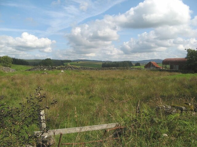
White Hill is a prominent hill located in the historic county of Kirkcudbrightshire in southwest Scotland. Standing at an elevation of approximately 345 meters (1,132 feet), it offers stunning panoramic views of the surrounding countryside. The hill is situated about 7 kilometers (4.3 miles) southeast of the town of Kirkcudbright and is easily accessible by foot or by car.

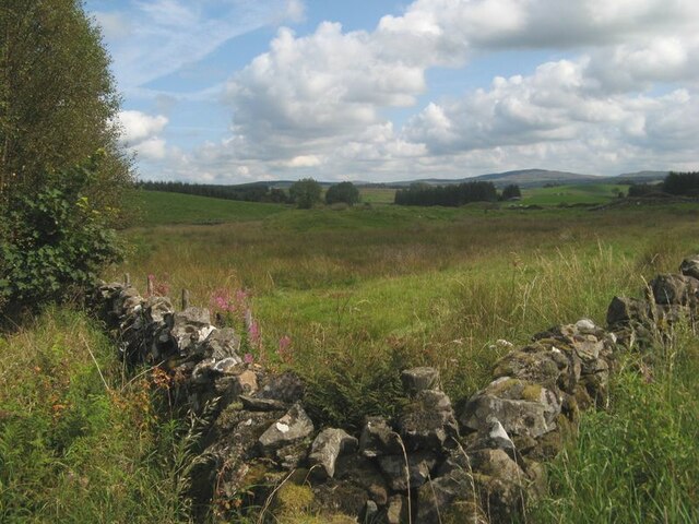
White Hill is characterized by its distinctive white appearance, which is attributed to the presence of exposed white quartzite rock on its slopes. This unique feature not only adds to the visual appeal of the hill but also contributes to its name. The hill is covered in lush grass and is interspersed with a variety of wildflowers, creating a picturesque landscape.

The summit of White Hill provides an excellent vantage point, offering breathtaking views of the rolling landscape of Kirkcudbrightshire. On a clear day, it is possible to see the Solway Firth and even the distant peaks of the Lake District in northern England. The hill is a popular destination for hikers and nature enthusiasts, attracting visitors who appreciate its natural beauty and tranquility.

In addition to its aesthetic value, White Hill also has historical significance. It is believed to have been a site of human activity since prehistoric times, with archaeological evidence suggesting the presence of ancient settlements in the area. The hill is a testament to the rich cultural and natural heritage of Kirkcudbrightshire, providing visitors with a glimpse into the region's past while offering a serene and captivating experience in the present.

If you have any feedback on the listing, please let us know in the comments section below.

White Hill Images

Images are sourced within 2km of 55.078119/-3.9819035 or Grid Reference NX7377. Thanks to Geograph Open Source API. All images are credited.

At Auchenvey Plantation A winter view showing hardwood planting near the Crogo Burn.
At Auchenvey Plantation
A winter view showing hardwood planting near the Crogo Burn.
Corner of walls Pasture land by forestry at Auchenvey.
Corner of walls
Pasture land by forestry at Auchenvey.
Field and farm Damp pasture and outbuildings at Auchenvey.
Field and farm
Damp pasture and outbuildings at Auchenvey.
Shepherds' Cairn on Caldow Moor A Shepherds' cairn on Caldow Moor now hidden by the forestry.
Shepherds' Cairn on Caldow Moor
A Shepherds' cairn on Caldow Moor now hidden by the forestry.
Small Shepherds' Cairn on Caldow Moor Small Shepherds' cairn on Caldow Moor now covered by woodland.
Small Shepherds' Cairn on Caldow Moor
Small Shepherds' cairn on Caldow Moor now covered by woodland.
Rough grazing near Crogo Mill An area of rough grazing near Crogo Mill.
Rough grazing near Crogo Mill
An area of rough grazing near Crogo Mill.
A forestry road in Garcrogo Plantation Sitka trees on Caldow Moor.
A forestry road in Garcrogo Plantation
Sitka trees on Caldow Moor.
Forest road, Garcrogo
Track leading to Barmark, Corsock
Barmark Farm, Corsock
Forest track near Barmark Hill A pleasant mossy green track. Ideal for cycling along.
Forest track near Barmark Hill
A pleasant mossy green track. Ideal for cycling along.
Forest track west of Barmark Hill Not shown on the OS map this track leads towards Auchenvey
Forest track west of Barmark Hill
Not shown on the OS map this track leads towards Auchenvey
Entrance to Crogo Mill, Corsock
Low Arvie, Corsock
Low Arvie, Corsock
Roadside meadowsweet The road north from Corsock near Crogo Mill
Roadside meadowsweet
The road north from Corsock near Crogo Mill
Meadowsweet and Stonechat
Pale Blue Silage
Pale Blue Silage
Auchenvey
Auchenvey
Show me another place!

White Hill is located at Grid Ref: NX7377 (Lat: 55.078119, Lng: -3.9819035)

Unitary Authority: Dumfries and Galloway

Police Authority: Dumfries and Galloway

What 3 Words

///sprinting.families.column. Near Castle Douglas, Dumfries & Galloway

Related Wikis

Corsock

Corsock (Scottish Gaelic: Corsag) is a village in the historical county of Kirkcudbrightshire, Dumfries and Galloway, south-west Scotland. It is located...

Dumfries and Galloway

Dumfries and Galloway (Scots: Dumfries an Gallowa; Scottish Gaelic: Dùn Phrìs is Gall-Ghaidhealaibh) is one of the 32 unitary council areas of Scotland...

Craigenputtock

Craigenputtock (usually spelled by the Carlyles as Craigenputtoch) is an estate in Scotland where Thomas Carlyle lived from 1828 to 1834. He wrote several...

Glenlair House

Glenlair, near the village of Corsock in the historical county of Kirkcudbrightshire, in Dumfries and Galloway, was the home of the physicist James Clerk...

Nearby Amenities

Located within 500m of 55.078119,-3.9819035
Auchenvey
Naptan AtcoCode: 680001038333
Naptan Bearing: NW
Naptan BusStopType: CUS
Naptan CommonName: Auchenvey
Naptan Indicator: opp Road End
Naptan Landmark: Auchenvey
Naptan NaptanCode: 34235967
Naptan Notes: none
Naptan Street: A712
Naptan Verified: no
Source: naptan_import
Lat/Long: 55.0752978/-3.9828648
Auchenvey
Naptan AtcoCode: 680001038444
Naptan Bearing: SE
Naptan BusStopType: CUS
Naptan CommonName: Auchenvey
Naptan Indicator: Road End
Naptan Landmark: Auchenvey
Naptan NaptanCode: 34235965
Naptan Notes: none
Naptan Street: A712
Naptan Verified: no
Source: naptan_import
Lat/Long: 55.0751894/-3.9823424
Power: pole
Lat/Long: 55.0747305/-3.9778683
Power: pole
Lat/Long: 55.0746344/-3.9792598
Power: pole
Lat/Long: 55.0745456/-3.980611
Power: pole
Lat/Long: 55.0744763/-3.9816838
Power: pole
Lat/Long: 55.074379/-3.9832049
Power: pole
Lat/Long: 55.0748339/-3.9850681
Power: pole
Lat/Long: 55.0751209/-3.9862854
Power: pole
Lat/Long: 55.0753921/-3.9874411
Power: pole
Lat/Long: 55.0743291/-3.9806683
Power: pole
Lat/Long: 55.0738755/-3.9807767
Power: pole
Lat/Long: 55.0747804/-3.9810783
Power: pole
Lat/Long: 55.0750248/-3.9815818
Power: pole
Lat/Long: 55.0753119/-3.9821767
Power: pole
Lat/Long: 55.0755466/-3.9826929
The data included in this document is from www.openstreetmap.org. The data is made available under ODbL.

Have you been to White Hill?

Leave your review of White Hill below (or comments, questions and feedback).