Meall Reamhar

Hill, Mountain in Perthshire

Scotland

Meall Reamhar

Trig point on Creag Uchdag ('crag of hollows') Decorated with a bit of fleece on top!

The silhouettes of the Tarmachan Ridge and, most prominently, the Ben Lawers group, are visible in the distance.
Trig point on Creag Uchdag ('crag of hollows') Credit: Alan O'Dowd

Meall Reamhar is a prominent hill located in the county of Perthshire, Scotland. It is part of the Southern Highlands and stands at an impressive height of 649 meters (2,129 feet) above sea level. The hill is situated near the village of Aberfeldy and is a popular destination for hikers and outdoor enthusiasts.

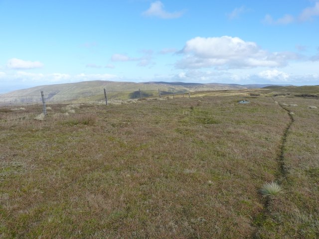
Meall Reamhar is characterized by its rugged and rocky terrain, making it a challenging but rewarding climb. The ascent offers stunning panoramic views of the surrounding landscape, including the picturesque Loch Tay and the rolling hills of Perthshire. On a clear day, it is even possible to catch a glimpse of the towering Ben Lawers, the highest mountain in the southern part of the Scottish Highlands.

The hill is home to a variety of wildlife, including red deer, mountain hares, and a wide range of bird species. It is not uncommon to spot golden eagles soaring overhead or hear the distinctive call of a curlew in the distance.

Hiking routes to Meall Reamhar are well-marked and easily accessible, with several starting points available depending on the preferred level of difficulty. The most popular route begins from the village of Kenmore, leading walkers through a mixture of moorland, heather, and grassy slopes before reaching the summit.

Overall, Meall Reamhar provides a stunning outdoor experience for nature lovers and offers a chance to immerse oneself in the beauty of Perthshire's countryside.

If you have any feedback on the listing, please let us know in the comments section below.

Meall Reamhar Images

Images are sourced within 2km of 56.475254/-4.1030931 or Grid Reference NN7033. Thanks to Geograph Open Source API. All images are credited.

Trig point on Creag Uchdag ('crag of hollows') Decorated with a bit of fleece on top!

The silhouettes of the Tarmachan Ridge and, most prominently, the Ben Lawers group, are visible in the distance.
Trig point on Creag Uchdag ('crag of hollows')
Decorated with a bit of fleece on top! The silhouettes of the Tarmachan Ridge and, most prominently, the Ben Lawers group, are visible in the distance.
Creag Uchdag ('crag of hollows') The summit of a rather sprawling Corbett (Scottish mountain over 2,500ft but less than 3,000ft above sea level, with a drop of at least 500ft) at the head of Glen Lednock.
Creag Uchdag ('crag of hollows')
The summit of a rather sprawling Corbett (Scottish mountain over 2,500ft but less than 3,000ft above sea level, with a drop of at least 500ft) at the head of Glen Lednock.
Toll na Poite ('hollow of the pot') The peaty pool to the left of the hillock on the right is named Toll na Poite on the 1:25,000 scale map.
Toll na Poite ('hollow of the pot')
The peaty pool to the left of the hillock on the right is named Toll na Poite on the 1:25,000 scale map.
The flank of Meall Dubh Mòr Looking from Meall Dubh Mòr ('the big, black, round hill') across Coire an Eachdarra ('corrie of the pound or poind-fold'), a name which suggests an enclosure for holding livestock.
The flank of Meall Dubh Mòr
Looking from Meall Dubh Mòr ('the big, black, round hill') across Coire an Eachdarra ('corrie of the pound or poind-fold'), a name which suggests an enclosure for holding livestock.
Craggy outcrops on the western side of Creag Uchdag
A grassy outlier on Creag Uchdag A small grassy hillock on the western flank of the Corbett; other hills in the moorland above Ardeonaig lie beyond.
A grassy outlier on Creag Uchdag
A small grassy hillock on the western flank of the Corbett; other hills in the moorland above Ardeonaig lie beyond.
Upper waters of the Eas Domhain A tributary of the Finglen Burn, this rises high on Creag Uchdag.
Upper waters of the Eas Domhain
A tributary of the Finglen Burn, this rises high on Creag Uchdag.
Creag Uchdag - just south of the summit ridge
Along the summit ridge of Creag Uchdag It's not really a 'ridge', more a long grassy field with a series of disused boundary fences running through it, but the actual summit and trig lie on one of the bumps in the middle distance.
Along the summit ridge of Creag Uchdag
It's not really a 'ridge', more a long grassy field with a series of disused boundary fences running through it, but the actual summit and trig lie on one of the bumps in the middle distance.
Creag Uchdag - summit trig At the summit of the hill, the trig pillar bears flushbracket number S6473, and looks down towards Loch Lednock and its dam in <a href="https://www.geograph.org.uk/gridref/NN7228">NN7228</a>.
Creag Uchdag - summit trig
At the summit of the hill, the trig pillar bears flushbracket number S6473, and looks down towards Loch Lednock and its dam in NN7228.
NW along the summit ridge of Creag Uchdag
North across Meall Ramhar to Meall nan Oighreag An area of slightly eroded peat lies at the bealach between Creag Uchdag and Meall nan Oighreag. The distant hills are on the far side of Loch Tay.
North across Meall Ramhar to Meall nan Oighreag
An area of slightly eroded peat lies at the bealach between Creag Uchdag and Meall nan Oighreag. The distant hills are on the far side of Loch Tay.
On the boggy bealach heading for Meall nan Oighreag The grassy northern slopes of Creag Uchdag (behind us) give way to this rather boggy pass, before climbing again on drier ground to Meall nan Oighreag on the skyline.
On the boggy bealach heading for Meall nan Oighreag
The grassy northern slopes of Creag Uchdag (behind us) give way to this rather boggy pass, before climbing again on drier ground to Meall nan Oighreag on the skyline.
In the peat hags Despite appearances, the 'bog' was actually no more than a couple of inches deep at any point, and quite easy to walk through. This sort of ground isn't always quite so obliging.
In the peat hags
Despite appearances, the 'bog' was actually no more than a couple of inches deep at any point, and quite easy to walk through. This sort of ground isn't always quite so obliging.
Abandoned mine buildings on the south side of Meall nan Oighreag A small lead mine of rather uncertain age was worked just uphill from this point; these ruined buildings are associated with that, and possibly provided some rudimentary shelter for the miners.
Abandoned mine buildings on the south side of Meall nan Oighreag
A small lead mine of rather uncertain age was worked just uphill from this point; these ruined buildings are associated with that, and possibly provided some rudimentary shelter for the miners.
Lead mine buildings The ruins of a 2- or 3-room building on the south side of Meall nan Oighreag, which is associated with the disused lead mine on the hill just above them.
Lead mine buildings
The ruins of a 2- or 3-room building on the south side of Meall nan Oighreag, which is associated with the disused lead mine on the hill just above them.
Fenceposts at the summit of Meall nan Oighreag The highest point of the hill is just about here - at the bend in the fence.
Fenceposts at the summit of Meall nan Oighreag
The highest point of the hill is just about here - at the bend in the fence.
Eastwards view from the summit of Meall nan Oighreag Roughly eastwards from the summit across the wild uplands between Loch Tay and Loch Earn; the long, low hill on the left is the Corbett of Creagan na Beinne in <a href="https://www.geograph.org.uk/gridref/NN7436">NN7436</a>.
Eastwards view from the summit of Meall nan Oighreag
Roughly eastwards from the summit across the wild uplands between Loch Tay and Loch Earn; the long, low hill on the left is the Corbett of Creagan na Beinne in NN7436.
Show me another place!

Meall Reamhar is located at Grid Ref: NN7033 (Lat: 56.475254, Lng: -4.1030931)

Unitary Authority: Stirling

Police Authority: Forth Valley

What 3 Words

///timer.jiggle.payout. Near Comrie, Perth & Kinross

Nearby Locations

Meall Reamhar

Related Wikis

Ardeonaig

Ardeonaig (Gaelic: Aird Eòdhanaig) is a hamlet on the southern shore of Loch Tay in the Stirling Council area of Scotland. It is approximately 7 miles...

Tomnadashan

Tomnadashan was a hamlet southwest of Ardtalnaig in Scotland. John Campbell, 2nd Marquess of Breadalbane tried to mine copper, gold, and sulphur there...

Creagan na Beinne

Creagan na Beinne is a hill in the Scottish Highlands lying to the south-east of Loch Tay in the group of rolling hills and moors whose highest point in...

Loch Tay

Loch Tay (Scottish Gaelic: Loch Tatha) is a freshwater loch in the central highlands of Scotland, in the Perth and Kinross and Stirling council areas....

Have you been to Meall Reamhar?

Leave your review of Meall Reamhar below (or comments, questions and feedback).