Càrn Mairg

Hill, Mountain in Perthshire

Scotland

Càrn Mairg

Along the ridge of Meall a' Bhàrr Meall a' Bhàrr is a minor, elongated top along the Carn Mairg range of mountains on the north side of Glen Lyon. The highest peak of the group is Carn Mairg itself which is the obvious distant feature.
Along the ridge of Meall a' Bhàrr Credit: Trevor Littlewood

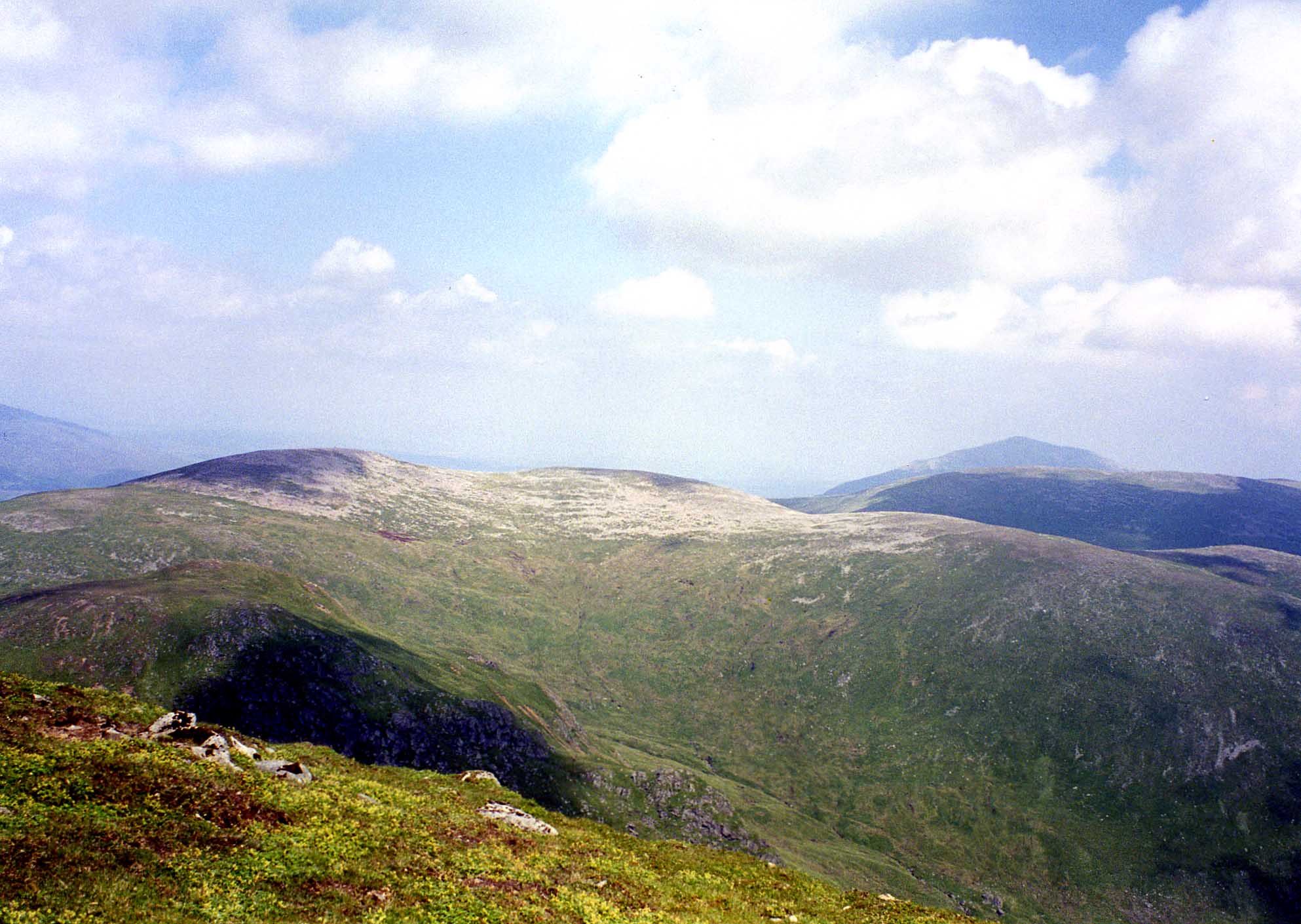
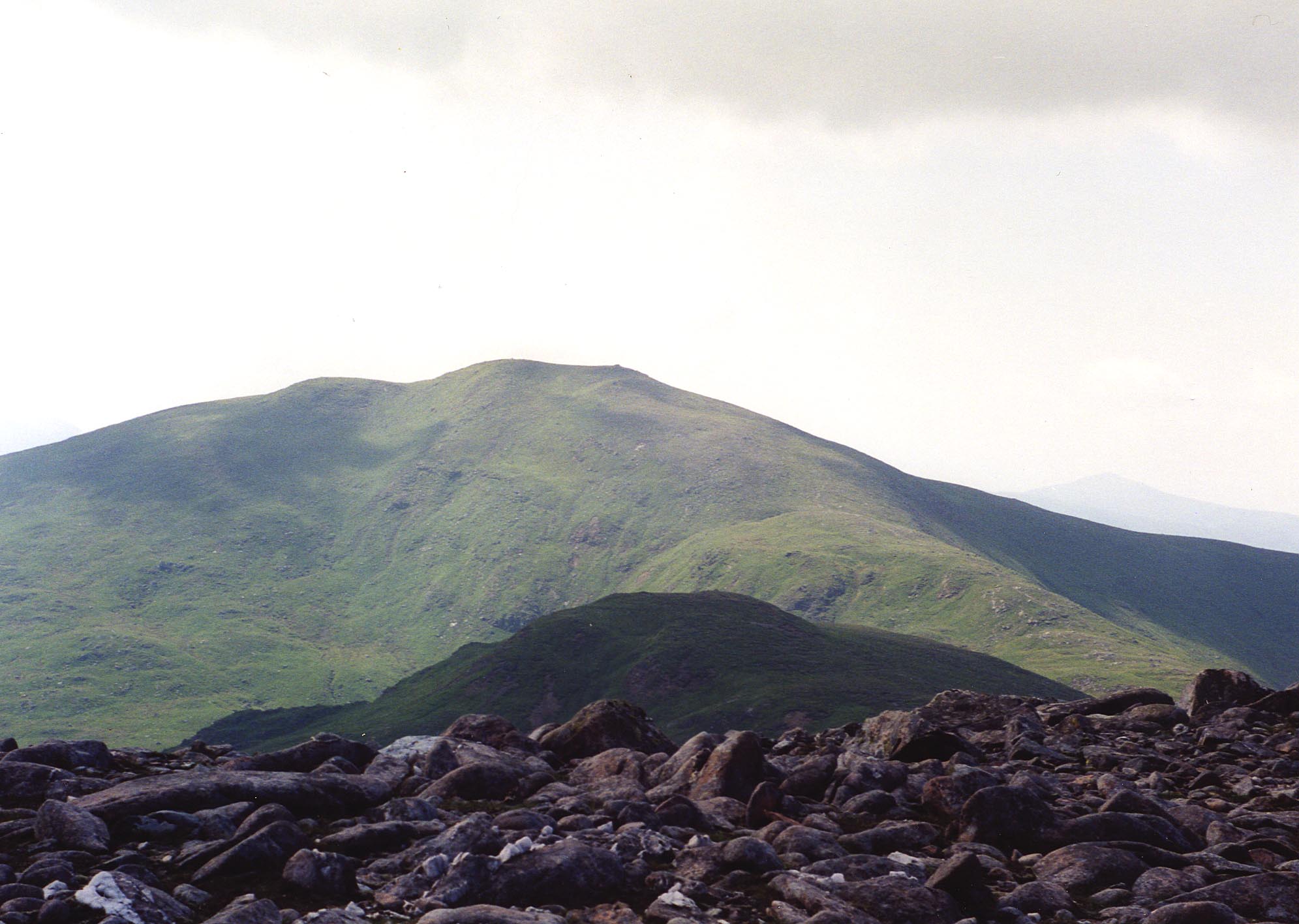
Càrn Mairg is a prominent hill located in the Perthshire region of Scotland. It forms part of the Grampian Mountains, which stretch across the central and northeastern part of the country. With an elevation of 1,046 meters (3,432 feet), Càrn Mairg offers stunning panoramic views of the surrounding landscape.

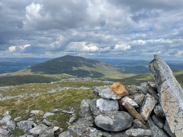
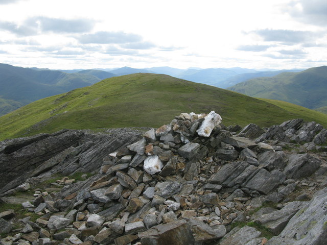
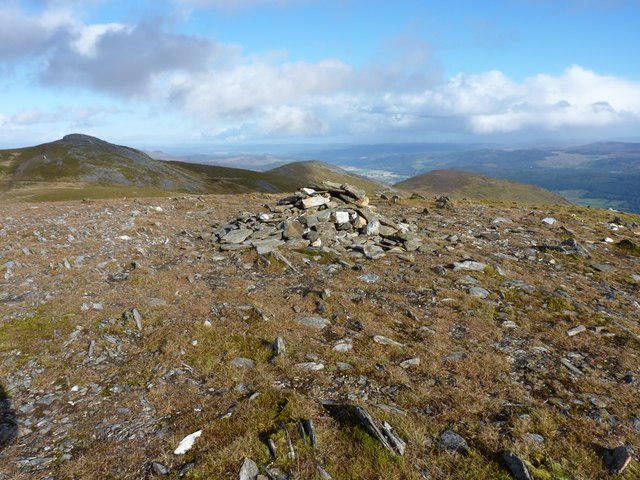
The hill is characterized by its rugged terrain, featuring steep slopes and craggy peaks. It is composed mainly of granite and schist, which give it a distinctive appearance. The summit of Càrn Mairg is marked by a cairn, a pile of stones that serves as a traditional marker for hillwalkers.

Càrn Mairg is a popular destination for hikers and outdoor enthusiasts, offering a range of routes that cater to different skill levels. The most commonly used starting point is the village of Lawers, from where a well-marked path leads up the mountain. The ascent can be challenging, particularly in adverse weather conditions, but the reward is the breathtaking view from the top.

The area surrounding Càrn Mairg is known for its rich biodiversity. The hill is home to a variety of plant and animal species, including red deer, mountain hares, and various bird species. It is also part of a designated Site of Special Scientific Interest (SSSI), recognizing its ecological importance.

Overall, Càrn Mairg is a magnificent natural landmark in Perthshire, offering outdoor enthusiasts a chance to experience the beauty of Scotland's mountainous terrain. It provides a challenging yet rewarding hiking experience and showcases the diverse flora and fauna of the region.

If you have any feedback on the listing, please let us know in the comments section below.

Càrn Mairg Images

Images are sourced within 2km of 56.634516/-4.1457841 or Grid Reference NN6851. Thanks to Geograph Open Source API. All images are credited.

Along the ridge of Meall a' Bhàrr Meall a' Bhàrr is a minor, elongated top along the Carn Mairg range of mountains on the north side of Glen Lyon. The highest peak of the group is Carn Mairg itself which is the obvious distant feature.
Along the ridge of Meall a' Bhàrr
Meall a' Bhàrr is a minor, elongated top along the Carn Mairg range of mountains on the north side of Glen Lyon. The highest peak of the group is Carn Mairg itself which is the obvious distant feature.
Rocks on Meall Liath Meall Liath is regarded as a Munro Top rather than a Munro; It's one of a number of peaks of the Carn Mairg range on the north side of Glen Lyon. Schiehallion is the other mountain.
Rocks on Meall Liath
Meall Liath is regarded as a Munro Top rather than a Munro; It's one of a number of peaks of the Carn Mairg range on the north side of Glen Lyon. Schiehallion is the other mountain.
Carn Mairg summit ridge Large mounds of boulders are encountered during the walk along the ridge to the rock strewn summit of Carn Mairg.
Carn Mairg summit ridge
Large mounds of boulders are encountered during the walk along the ridge to the rock strewn summit of Carn Mairg.
Summit of Carn Mairg Cairn on the stone strewn summit with the similarly rock and stone strewn mass of Schiehallion in the distance.
Summit of Carn Mairg
Cairn on the stone strewn summit with the similarly rock and stone strewn mass of Schiehallion in the distance.
The Carn Mairg range over Gleann Mòr from the side of Schiehallion Not exactly sure of the camera position but somewhere on a rough line (no path) up Schiehallion.  Soon cloud was entered and route-finding became a little nerve wracking.  I climbed the main peaks of the Carn Mairg range eighteen months later.  In this view Meall Liath is in the centre with Meall nan Eun to the left.  The main peak of Carn Mairg is in cloud right of centre.  Position for image supported by using the 3D aerial facility in OS Mapping but could be lower on the side of Schiehallion.
The Carn Mairg range over Gleann Mòr from the side of Schiehallion
Not exactly sure of the camera position but somewhere on a rough line (no path) up Schiehallion. Soon cloud was entered and route-finding became a little nerve wracking. I climbed the main peaks of the Carn Mairg range eighteen months later. In this view Meall Liath is in the centre with Meall nan Eun to the left. The main peak of Carn Mairg is in cloud right of centre. Position for image supported by using the 3D aerial facility in OS Mapping but could be lower on the side of Schiehallion.
Carn Mairg View from the north, into Coire Chruach Sneachda.
Carn Mairg
View from the north, into Coire Chruach Sneachda.
View across the grid Schiehallion in the distance
View across the grid
Schiehallion in the distance
View down from summit of Meall na Aighean Looking towards the western end of the summit ridge.
View down from summit of Meall na Aighean
Looking towards the western end of the summit ridge.
The western ridge from Meall na Aighean The dominant peak on the right is Meall Garbh and to the left is Glen Lyon.
The western ridge from Meall na Aighean
The dominant peak on the right is Meall Garbh and to the left is Glen Lyon.
Meall nan Aighean Summit Cairn Looking towards the subsidiary top of Meall nan Aighean which also has small cairn,
Meall nan Aighean Summit Cairn
Looking towards the subsidiary top of Meall nan Aighean which also has small cairn,
Cairn on the minor top of Meall nan Aighean Looking east towards the main summit.
Cairn on the minor top of Meall nan Aighean
Looking east towards the main summit.
West Ridge of Meall nan Aighean Looking down the ridge towards Glen Lyon.
West Ridge of Meall nan Aighean
Looking down the ridge towards Glen Lyon.
Grassy spur above Gleann Pollaidh Near the main path up from Invervar, this grassy spur juts out into Gleann Pollaidh, with a fine view of the day's round of the Glen Lyon 4.
Grassy spur above Gleann Pollaidh
Near the main path up from Invervar, this grassy spur juts out into Gleann Pollaidh, with a fine view of the day's round of the Glen Lyon 4.
Downhill into Gleann Pollaidh
Up onto Meall na Aighean The upper part of the route from Invervar onto the first Munro (if doing the round the 'normal' way) of the day.
Up onto Meall na Aighean
The upper part of the route from Invervar onto the first Munro (if doing the round the 'normal' way) of the day.
Summit cairn with Schiehallion on the background
Hilltop lochans on Meall na Aighean At 3120', these must count amongst the highest standing water in the area. They feed the Allt Linntich which drains down the southern flank of Meall na Aighean into the River Lyon near Dornoch Lodge.
Hilltop lochans on Meall na Aighean
At 3120', these must count amongst the highest standing water in the area. They feed the Allt Linntich which drains down the southern flank of Meall na Aighean into the River Lyon near Dornoch Lodge.
Meall na Aighean - the West Top This was once considered the summit of the Munro, but in clear weather it's obviously a lot lower than the true high point (which is off shot to the right of this picture). The hills in the background here are Carn Mairg, Meall Liath and Meall nan Eun.
Meall na Aighean - the West Top
This was once considered the summit of the Munro, but in clear weather it's obviously a lot lower than the true high point (which is off shot to the right of this picture). The hills in the background here are Carn Mairg, Meall Liath and Meall nan Eun.
Show me another place!

Càrn Mairg is located at Grid Ref: NN6851 (Lat: 56.634516, Lng: -4.1457841)

Unitary Authority: Perth and Kinross

Police Authority: Tayside

What 3 Words

///proven.fortnight.riper. Near Aberfeldy, Perth & Kinross

Related Wikis

Càrn Mairg

Càrn Mairg (Scottish Gaelic: Càrn na Mairc) is a mountain in the Breadalbane region of the Scottish Highlands, with a height of 1,042 metres (3,419 ft...

Meall nan Aighean

Meall nan Aighean is a Scottish mountain in the council area of Perth and Kinross. It stands in a group of four Munros known as the Càrn Mairg group or...

Meall Garbh (Càrn Mairg Group)

Meall Garbh is a mountain on the north side of Glen Lyon in the Scottish Highlands. The flat summit of the hill has two tops of almost equal height, the...

Schiehallion

Schiehallion (; Scottish Gaelic: Sìth Chailleann, IPA: [ʃiˈxaʎən̪ˠ]) is a prominent cone-shaped mountain in the Breadalbane region of the Scottish Highlands...

Schiehallion experiment

The Schiehallion experiment was an 18th-century experiment to determine the mean density of the Earth. Funded by a grant from the Royal Society, it was...

Càrn Gorm

Càrn Gorm is a mountain in the Breadalbane region of the Scottish Highlands, with a height of 1,029 metres (3,376 ft). It stands in a group of four Munro...

Fortingall

Fortingall (Scottish Gaelic: Fartairchill) (lit. "Escarpment Church"—i.e. "church at the foot of an escarpment or steep slope") is a small village in Glen...

Càrn na Marbh

Càrn na Marbh (meaning "mound" or "cairn of the dead") is a re-used Bronze Age tumulus, located in Fortingall in Perthshire, Scotland. The mound was used...

Nearby Amenities

Located within 500m of 56.634516,-4.1457841
Càrn Mairg
Description: Hill of sorrow
Ele: 1041
Marilyn: yes
Munro: yes
Munro Number: M091
Natural: peak
Prominence: 465
Source: NPE
Wikidata: Q5202305
Wikipedia: en:Càrn Mairg
Lat/Long: 56.6346219/-4.1457221
The data included in this document is from www.openstreetmap.org. The data is made available under ODbL.

Have you been to Càrn Mairg?

Leave your review of Càrn Mairg below (or comments, questions and feedback).