Sròn Mhòr

Hill, Mountain in Perthshire

Scotland

Sròn Mhòr

Hydro intake
Hydro intake Credit: mountainmonkey

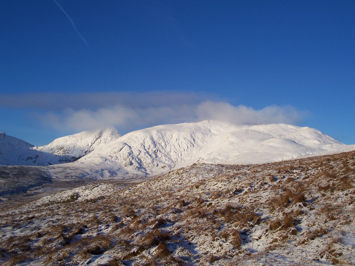
Located in the heart of Perthshire, Scotland, Sròn Mhòr is a prominent hill that offers breathtaking views and an enriching outdoor experience. Standing at an elevation of 1,483 feet (452 meters), it is a popular destination for both locals and tourists seeking a picturesque hiking adventure.

Sròn Mhòr is characterized by its distinct shape, with a steep and rugged terrain that challenges hikers of all skill levels. The hill is covered in a variety of vegetation, including heather, grasses, and some scattered trees, creating a beautiful and diverse landscape. As visitors ascend, they are treated to stunning panoramic views of the surrounding countryside, including the rolling hills, lush forests, and sparkling Loch Tay.

The hill is well-marked with trails that cater to different levels of difficulty, allowing visitors to choose their preferred route. The shorter paths offer a more gentle ascent, while the longer ones provide a more challenging and rewarding experience. Along the way, hikers may encounter wildlife such as deer, hares, and a variety of bird species.

At the summit, hikers are rewarded with a breathtaking view of the surrounding Perthshire countryside, with its picturesque villages, sparkling lochs, and majestic mountains. On a clear day, one can even catch a glimpse of Ben Lawers, the highest mountain in the southern Highlands.

Overall, Sròn Mhòr in Perthshire is a must-visit destination for outdoor enthusiasts and nature lovers seeking a memorable and invigorating experience in the Scottish Highlands.

If you have any feedback on the listing, please let us know in the comments section below.

Sròn Mhòr Images

Images are sourced within 2km of 56.560379/-4.1546195 or Grid Reference NN6743. Thanks to Geograph Open Source API. All images are credited.

Hydro intake
Hydro intake
Spillway in Lawers Burn
Shielings Above Lawers Burn Old shielings on the east bank of the Lawers Burn at East Mealour.  Ben Lawers is the peak at the right of picture and all 4 Munros round Lochan nan Cat can be seen.
Shielings Above Lawers Burn
Old shielings on the east bank of the Lawers Burn at East Mealour. Ben Lawers is the peak at the right of picture and all 4 Munros round Lochan nan Cat can be seen.
Lawers from the Big Nose Ben Lawers, An Stùc and Meall Garbh above the Lawers Burn as seen from the slopes of Sròn Mhòr or big nose - Sròn Mhòr itself part of the Munro of Meall Greigh.
Lawers from the Big Nose
Ben Lawers, An Stùc and Meall Garbh above the Lawers Burn as seen from the slopes of Sròn Mhòr or big nose - Sròn Mhòr itself part of the Munro of Meall Greigh.
Meall Greigh Summit View The view of the lovely circuit of 4 Munros round Lochan nan Cat - seen fairly central in the photo.
Ahead of me are Meall Garbh, An Stuc and Ben Lawers - Scotland's 10th highest summit.
Meall Greigh Summit View
The view of the lovely circuit of 4 Munros round Lochan nan Cat - seen fairly central in the photo. Ahead of me are Meall Garbh, An Stuc and Ben Lawers - Scotland's 10th highest summit.
Moorland above the Lawers Burn Looking towards An Stuc ('the peak') and Meall Garbh (the 'rough, rounded hill'), both part of the Ben Lawers group.
Moorland above the Lawers Burn
Looking towards An Stuc ('the peak') and Meall Garbh (the 'rough, rounded hill'), both part of the Ben Lawers group.
Lone pine on East Mealour This small hillock appears to derive its name from the Gaelic Meall Odhar ('the rounded, dun-coloured hill').

Part of the Ben Lawers group is visible in the background - the small sharp peak of An Stuc and the bulkier Meall Garbh.
Lone pine on East Mealour
This small hillock appears to derive its name from the Gaelic Meall Odhar ('the rounded, dun-coloured hill'). Part of the Ben Lawers group is visible in the background - the small sharp peak of An Stuc and the bulkier Meall Garbh.
Larch trees on East Mealour This small hillock appears to derive its name from the Gaelic 'Meall Odhar' - which translates to English as rounded, dun-coloured hill.
Larch trees on East Mealour
This small hillock appears to derive its name from the Gaelic 'Meall Odhar' - which translates to English as rounded, dun-coloured hill.
Loch Tay from East Mealour A fine view of the loch can be had from the top of this small hillock not far from the path into the south-eastern corries of the Ben Lawers group.
Loch Tay from East Mealour
A fine view of the loch can be had from the top of this small hillock not far from the path into the south-eastern corries of the Ben Lawers group.
Sròn Mhòr Sròn Mhòr ('the big nose' in Gaelic) lies at the south-eastern end of Meall Greigh, one of the less dramatic of the Munros in the Ben Lawers group.
Sròn Mhòr
Sròn Mhòr ('the big nose' in Gaelic) lies at the south-eastern end of Meall Greigh, one of the less dramatic of the Munros in the Ben Lawers group.
Hydro-electric dam below Meall Garbh The dam, on the Lawers Burn, blends in reasonably well.  The shiny metal railings on the left seem a bit more intrusive.

Photographed at around noon on a crisp, bright late February day.
Hydro-electric dam below Meall Garbh
The dam, on the Lawers Burn, blends in reasonably well. The shiny metal railings on the left seem a bit more intrusive. Photographed at around noon on a crisp, bright late February day.
Ben Lawers from the east A view across moorland from the path by the Lawers Burn.
Ben Lawers from the east
A view across moorland from the path by the Lawers Burn.
Lawers Burn This burn flows from Lochan nan Cat and Lochan nan Uan high in the south-east corrie of Ben Lawers and empties directly into Loch Tay.
Lawers Burn
This burn flows from Lochan nan Cat and Lochan nan Uan high in the south-east corrie of Ben Lawers and empties directly into Loch Tay.
Summit of Meall Greigh Looking towards Ben Lawers
Summit of Meall Greigh
Looking towards Ben Lawers
Summit of Meall Greigh - View NE
Summit of Meall Greigh - View towards Ben Lawers
Lawers Burn
Lawers Burn
Summit of Meall Greigh
Show me another place!

Sròn Mhòr is located at Grid Ref: NN6743 (Lat: 56.560379, Lng: -4.1546195)

Unitary Authority: Perth and Kinross

Police Authority: Tayside

What 3 Words

///mailboxes.eaten.shadows. Near Aberfeldy, Perth & Kinross

Nearby Locations

Meall Greigh Sròn Mhòr

Related Wikis

Meall Greigh

Meall Greigh is a mountain in the southern part of the Scottish Highlands. With Meall Garbh it forms the north-eastern end of the Ben Lawers range. �...

Meall Garbh (Lawers Group)

Meall Garbh is a mountain in the southern part of the Scottish Highlands. With Meall Greigh it forms the north-eastern end of the Ben Lawers range. Its...

Lawers

Lawers is a village situated in rural Perthshire, Scotland. It lies on the banks of Loch Tay and at the foot of Ben Lawers. It was once part of a vibrant...

An Stùc

An Stùc, meaning "The Peak" in Gaelic, is a conically shaped Scottish mountain in the Ben Lawers range to the north of Loch Tay. It has been listed as...

Have you been to Sròn Mhòr?

Leave your review of Sròn Mhòr below (or comments, questions and feedback).