Back Hill

Hill, Mountain in Kirkcudbrightshire

Scotland

Back Hill

Logging road, Shield Willie Hill The access route to Margree Forest (there is no easy through routes as usual) split into a loop here. A one way system was signed for lorries but all traffic turned left today rather than right as instructed. The loop is waymarked as a core path.
Logging road, Shield Willie Hill Credit: Richard Webb

Back Hill is a prominent hill located in the historical county of Kirkcudbrightshire, in southwestern Scotland. Situated near the town of Kirkcudbright, it forms part of the wider Galloway Hills range. Back Hill stands at an elevation of approximately 336 meters (1,102 feet) above sea level, offering magnificent panoramic views of the surrounding countryside and coastline.

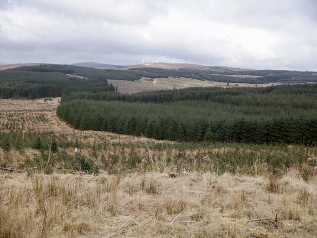
Characterized by its rolling moorland, heather-covered slopes, and rocky outcrops, Back Hill is a popular destination for outdoor enthusiasts, hikers, and nature lovers. The hill is known for its diverse flora and fauna, with a variety of wildflowers, grasses, and heather species adorning its landscape. Local wildlife, including red deer, mountain hares, and birds of prey, can often be spotted in the area.

Back Hill provides an accessible and enjoyable hiking experience, with a number of well-maintained trails leading to its summit. These paths, varying in difficulty, cater to hikers of different skill levels. On a clear day, the hill's summit offers breathtaking views of the Solway Firth and the surrounding rolling countryside, making it a favorite spot for photographers and nature enthusiasts.

Additionally, Back Hill holds historical significance, with remnants of ancient settlements and archaeological sites scattered across its slopes. These remnants offer valuable insights into the region's rich cultural heritage and provide a glimpse into the lives of its past inhabitants.

Overall, Back Hill is a picturesque and captivating destination that showcases the natural beauty and cultural heritage of Kirkcudbrightshire. Its accessibility, diverse wildlife, and stunning views make it a must-visit location for anyone exploring the region.

If you have any feedback on the listing, please let us know in the comments section below.

Back Hill Images

Images are sourced within 2km of 55.158949/-4.083065 or Grid Reference NX6786. Thanks to Geograph Open Source API. All images are credited.

Logging road, Shield Willie Hill The access route to Margree Forest (there is no easy through routes as usual) split into a loop here. A one way system was signed for lorries but all traffic turned left today rather than right as instructed. The loop is waymarked as a core path.
Logging road, Shield Willie Hill
The access route to Margree Forest (there is no easy through routes as usual) split into a loop here. A one way system was signed for lorries but all traffic turned left today rather than right as instructed. The loop is waymarked as a core path.
Road, Margree Forest 16 years after <a href="https://www.geograph.org.uk/photo/517057">NX6885 : Forest Road leading to Regland Loch.</a> with a new generation of trees.
Road, Margree Forest
16 years after NX6885 : Forest Road leading to Regland Loch. with a new generation of trees.
Deciduous patch, Margree Forest One of the tiny bits of the forest not covered in Sitka.
Deciduous patch, Margree Forest
One of the tiny bits of the forest not covered in Sitka.
Hill east of Divot Hill An evil thrash awaits those wishing to get to the summit (if you can find it in there)
Hill east of Divot Hill
An evil thrash awaits those wishing to get to the summit (if you can find it in there)
Margree Burn
Margree Burn
Margree Forest View towards Lawglass.
Margree Forest
View towards Lawglass.
Logging road, Margree Forest Over 1km of the road had been recently upgraded either for logging or a planned windfarm.
Logging road, Margree Forest
Over 1km of the road had been recently upgraded either for logging or a planned windfarm.
Clearing, Knocksting View towards the western of the two Knockstig lochs.
Clearing, Knocksting
View towards the western of the two Knockstig lochs.
Logging road, Knocksting It ends at Knocksting Loch
Logging road, Knocksting
It ends at Knocksting Loch
Margree Forest View towards wind turbines on Wether Hill. Turbines are planned here too.
Margree Forest
View towards wind turbines on Wether Hill. Turbines are planned here too.
Quarry, Mid Hill Beneath the triangulation pillar by Margree.
Quarry, Mid Hill
Beneath the triangulation pillar by Margree.
View towards Kilnair Hill Margree Forest
View towards Kilnair Hill
Margree Forest
Pond, Margree Forest
Margree Forest
Margree Forest
Clearing, Margree Forest
Logging road, Margree Forest Getting a fair bit of use from clear felling taking place at its end.
Logging road, Margree Forest
Getting a fair bit of use from clear felling taking place at its end.
Diesel truck, Hog Hill Supplying the forestry machinery working at Knockdollochan.
Diesel truck, Hog Hill
Supplying the forestry machinery working at Knockdollochan.
Summit, Hog Hill
Summit, Hog Hill
Show me another place!

Back Hill is located at Grid Ref: NX6786 (Lat: 55.158949, Lng: -4.083065)

Unitary Authority: Dumfries and Galloway

Police Authority: Dumfries and Galloway

What 3 Words

///version.deeply.footballers. Near Thornhill, Dumfries & Galloway

Nearby Locations

Back Hill

Related Wikis

Lochinvar

Lochinvar (or Lan Var) is a loch in the civil parish of Dalry in the historic county of Kirkcudbrightshire, Dumfries and Galloway Scotland. It is located...

Loch Howie

Loch Howie is a small, narrow, upland freshwater loch on the north side of Blackcraig Hill, approximately 18 miles (29 km) west of Dumfries, Scotland....

Loch Skae

Loch Skae is a small, upland freshwater loch to the north of Blackcraig Hill, approximately 18 miles (29 km) west of Dumfries, Scotland, 0.5 mi (0.80 km...

Barscobe Castle

Barscobe Castle is a 17th-century tower house in Balmaclellan, Kirkcudbrightshire, Scotland. It is a typical house of a country laird, and according to...

Nearby Amenities

Located within 500m of 55.158949,-4.083065
Margree
Place: locality
Lat/Long: 55.1555798/-4.0789234
The data included in this document is from www.openstreetmap.org. The data is made available under ODbL.

Have you been to Back Hill?

Leave your review of Back Hill below (or comments, questions and feedback).