Bryn Mawr

Hill, Mountain in Carmarthenshire

Wales

Bryn Mawr

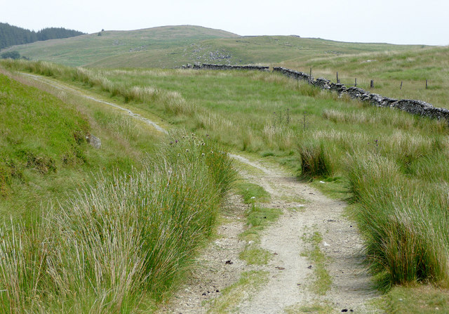
Heol fach i Ffarmers / Minor road to Ffarmers Heol fach wledig yn mynd i gyfeiriad Ffarmers.

A minor rural road heading in the direction of Ffarmers.
Heol fach i Ffarmers / Minor road to Ffarmers Credit: Alan Richards

The requested URL returned error: 429 Too Many Requests

If you have any feedback on the listing, please let us know in the comments section below.

Bryn Mawr Images

Images are sourced within 2km of 52.131494/-3.9511004 or Grid Reference SN6649. Thanks to Geograph Open Source API. All images are credited.

Heol fach i Ffarmers / Minor road to Ffarmers Heol fach wledig yn mynd i gyfeiriad Ffarmers.

A minor rural road heading in the direction of Ffarmers.
Heol fach i Ffarmers / Minor road to Ffarmers
Heol fach wledig yn mynd i gyfeiriad Ffarmers. A minor rural road heading in the direction of Ffarmers.
Carn Craig Twrch /Craig Twrch Cairn Dyma weddillion o Siambr Claddu Craig Twrch. Mae'r heneb yn dyddio nol i'r Oes Bres ac felly yn 4,000 oed. Sylwer bod y capfaen wedi cael ei symud oddi ar y cistfaen er mwyn dod o hyd i greiriau. Yn wreiddiol dadorchuddiwyd y garn gan gerrig ond fe ddaeth yn gwar cyfleus ar gyfer codi adeiladau a gwalydd. 

The remains of a 4,000 year old Bronze Age burial chamber known as Craig Twrch. Note that the capstone has been dislodged revealing its cistfaen. The capstone was removed centuries ago by likely treasure seekers. Originally, the cairn would have been covered by a stone mound but this has long gone and used as building material.
Carn Craig Twrch /Craig Twrch Cairn
Dyma weddillion o Siambr Claddu Craig Twrch. Mae'r heneb yn dyddio nol i'r Oes Bres ac felly yn 4,000 oed. Sylwer bod y capfaen wedi cael ei symud oddi ar y cistfaen er mwyn dod o hyd i greiriau. Yn wreiddiol dadorchuddiwyd y garn gan gerrig ond fe ddaeth yn gwar cyfleus ar gyfer codi adeiladau a gwalydd. The remains of a 4,000 year old Bronze Age burial chamber known as Craig Twrch. Note that the capstone has been dislodged revealing its cistfaen. The capstone was removed centuries ago by likely treasure seekers. Originally, the cairn would have been covered by a stone mound but this has long gone and used as building material.
Not quite the centre I'd hoped to take a photo from the exact geographical centre of the square, but it was 40 metres west of here over old forestry: tall plants, hidden stumps, deep water-filled holes.
Not quite the centre
I'd hoped to take a photo from the exact geographical centre of the square, but it was 40 metres west of here over old forestry: tall plants, hidden stumps, deep water-filled holes.
Llechau Uchaf Anhedd-dy o'r enw Llechau Uchaf.

A property known as Llechau Uchaf (trans. stones / slabs).
Llechau Uchaf
Anhedd-dy o'r enw Llechau Uchaf. A property known as Llechau Uchaf (trans. stones / slabs).
Capel Saron  /  Saron Chapel Saron, Capel y Trefnyddion a adeiladwyd yn 1836. Fe'i helaethwyd yn 1876. Yn 1909 roedd gan yr addoldy 84 o aelodau. Yn 2006 roedd 11 o ffyddloniaid yn cadw'r achos i fynd.  

Saron Methodist Chapel was built in 1836 and extended in 1876. In 1909 the remote meeting house had 84 members but in 2006 there were 11 worshippers.
Capel Saron / Saron Chapel
Saron, Capel y Trefnyddion a adeiladwyd yn 1836. Fe'i helaethwyd yn 1876. Yn 1909 roedd gan yr addoldy 84 o aelodau. Yn 2006 roedd 11 o ffyddloniaid yn cadw'r achos i fynd. Saron Methodist Chapel was built in 1836 and extended in 1876. In 1909 the remote meeting house had 84 members but in 2006 there were 11 worshippers.
Plas Newydd The ruins of a fascinatingly large dwelling shown on the old OS maps as Plas Newydd, situated north-west of Craig Twrch and just inside the county boundary on the Carmarthenshire side.
Plas Newydd
The ruins of a fascinatingly large dwelling shown on the old OS maps as Plas Newydd, situated north-west of Craig Twrch and just inside the county boundary on the Carmarthenshire side.
View down the Twrch Valley From above Wernfeudwy
View down the Twrch Valley
From above Wernfeudwy
Farmland in the Afon Twrch valley, Carmarthenshire This is a telephoto assisted image taken from the track at the south-western end of Craig Twrch.
Farmland in the Afon Twrch valley, Carmarthenshire
This is a telephoto assisted image taken from the track at the south-western end of Craig Twrch.
Stony road south of the Clywedog Plantation, Carmarthenshire This stony moorland track predates the Clywedog Plantation, but still continues through it, having been extended to the west to join the Llanfair Clydogau-Ffarmers road (formerly Roman Sarn Helen). A rock blockage at the forest entrance prevents vehicles using this as a way in.
Stony road south of the Clywedog Plantation, Carmarthenshire
This stony moorland track predates the Clywedog Plantation, but still continues through it, having been extended to the west to join the Llanfair Clydogau-Ffarmers road (formerly Roman Sarn Helen). A rock blockage at the forest entrance prevents vehicles using this as a way in.
Moorland and forest north of Ffarmers in Carmarthenshire A stony road enters the Clywedog Plantation here, but a rock blocks the way to vehicles at the gate.
Moorland and forest north of Ffarmers in Carmarthenshire
A stony road enters the Clywedog Plantation here, but a rock blocks the way to vehicles at the gate.
Carmarthenshire moorland by the Clywedog Plantation Looking towards Bryn Mawr from the stony road near the forest entrance.
Carmarthenshire moorland by the Clywedog Plantation
Looking towards Bryn Mawr from the stony road near the forest entrance.
Entrance to the Clywedog Plantation in Carmarthenshire The stony road into the forest comes from the public road between Ffarmers and Llanfair Clydogau, and predates the forest, but was extended through the trees to rejoin that public road at SN63914948. The strategic boulders prevent any use of the forestry road by vehicles larger than a quad-bike.
Entrance to the Clywedog Plantation in Carmarthenshire
The stony road into the forest comes from the public road between Ffarmers and Llanfair Clydogau, and predates the forest, but was extended through the trees to rejoin that public road at SN63914948. The strategic boulders prevent any use of the forestry road by vehicles larger than a quad-bike.
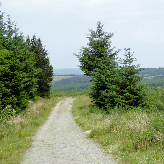
Forestry road north of Ffarmers in Carmarthenshire This stony road predates the Clywedog Plantation, but still continues through it, having been extended to the north and west, meandering to join the Llanfair Clydogau-Ffarmers road (formerly Roman Sarn Helen) at SN63954944.
Forestry road north of Ffarmers in Carmarthenshire
This stony road predates the Clywedog Plantation, but still continues through it, having been extended to the north and west, meandering to join the Llanfair Clydogau-Ffarmers road (formerly Roman Sarn Helen) at SN63954944.
Coniferous forest north of Ffarmers in Carmarthenshire This stony forestry road predates the Clywedog Plantation, but still continues through it, having been extended to the north and west, meandering to join the Llanfair Clydogau-Ffarmers road (formerly Roman Sarn Helen) at SN63954944.
Coniferous forest north of Ffarmers in Carmarthenshire
This stony forestry road predates the Clywedog Plantation, but still continues through it, having been extended to the north and west, meandering to join the Llanfair Clydogau-Ffarmers road (formerly Roman Sarn Helen) at SN63954944.
Forestry road north of Ffarmers in Carmarthenshire This stony forestry road extends a pre-existing one, meandering to join the Llanfair Clydogau-Ffarmers road (formerly Roman Sarn Helen) at SN63954944.
Forestry road north of Ffarmers in Carmarthenshire
This stony forestry road extends a pre-existing one, meandering to join the Llanfair Clydogau-Ffarmers road (formerly Roman Sarn Helen) at SN63954944.
Forestry landscape north of Ffarmers in Carmarthenshire Looking north across the Clywedog Plantation.
This stony forestry road extends a pre-existing one, meandering to join the Llanfair Clydogau-Ffarmers road (formerly Roman Sarn Helen) at SN63954944.
Forestry landscape north of Ffarmers in Carmarthenshire
Looking north across the Clywedog Plantation. This stony forestry road extends a pre-existing one, meandering to join the Llanfair Clydogau-Ffarmers road (formerly Roman Sarn Helen) at SN63954944.
Forestry road north of Ffarmers in Carmarthenshire Looking south.
This newer part of the stony road through the Clywedog Plantation links with one which predates the planting of the forest and leads to the Ffarmers/Llanfair-Clydogau public road (formerly Roman Sarn Helen) at SN64614810.
Forestry road north of Ffarmers in Carmarthenshire
Looking south. This newer part of the stony road through the Clywedog Plantation links with one which predates the planting of the forest and leads to the Ffarmers/Llanfair-Clydogau public road (formerly Roman Sarn Helen) at SN64614810.
Show me another place!

Bryn Mawr is located at Grid Ref: SN6649 (Lat: 52.131494, Lng: -3.9511004)

Unitary Authority: Carmarthenshire

Police Authority: Dyfed Powys

What 3 Words

///butterfly.clots.tunes. Near Llangybi, Ceredigion

Nearby Locations

Bryn Mawr

Related Wikis

Llanfair Clydogau

Llanfair Clydogau is a small village and community encompassing 3,232 hectares (7,990 acres), located about 4 miles (6.4 km) north-east of Lampeter on...

Pentre-rhew

Pentre-rhew is a hamlet in the community of Llanddewibrefi, Ceredigion, Wales, which is 58.3 miles (93.9 km) from Cardiff and 169.6 miles (272.9 km) from...

Gogoyan

Gogoyan is a hamlet in the community of Llanddewibrefi, Ceredigion, Wales, which is 58.9 miles (94.8 km) from Cardiff and 171.1 miles (275.3 km) from...

Llanddewi Brefi

Llanddewi Brefi (Welsh pronunciation: [ɬanˈðɛwi ˈbrɛvi]) is a village, parish and community of approximately 500 people in Ceredigion, Wales. The village...

Nearby Amenities

Located within 500m of 52.131494,-3.9511004
Bryn Mawr
Ele: 474
Natural: peak
Lat/Long: 52.1315513/-3.9519014
Carn Fawr
Historic: archaeological_site
Lat/Long: 52.1345781/-3.9460136
Historic: ruins
Lat/Long: 52.1313807/-3.9511173
Ele: 478
Natural: peak
Lat/Long: 52.1345923/-3.9462142
The data included in this document is from www.openstreetmap.org. The data is made available under ODbL.

Have you been to Bryn Mawr?

Leave your review of Bryn Mawr below (or comments, questions and feedback).