Cort-ma Law

Hill, Mountain in Stirlingshire

Scotland

Cort-ma Law

East side of Lecket Hill Rough grassland around Boyd's Burn.
East side of Lecket Hill Credit: Richard Webb

Cort-ma Law is a prominent hill located in Stirlingshire, Scotland. With an elevation of approximately 317 meters (1,040 feet), it is classified as a Corbett, which refers to a Scottish hill between 2,500 and 3,000 feet in height. Situated about 10 kilometers (6 miles) southwest of Stirling, Cort-ma Law offers stunning panoramic views of the surrounding landscape.

This hill is a popular destination for hikers and outdoor enthusiasts due to its relatively accessible nature and rewarding vistas. The ascent to Cort-ma Law is not particularly challenging, making it suitable for individuals of varying fitness levels. The well-defined path leading to the summit is well-maintained and offers a relatively easy walk.

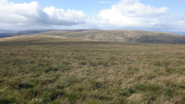
The summit of Cort-ma Law is marked by a trig point, providing a reference point for navigational purposes. On clear days, the panoramic views from the top include the Ochil Hills to the east, the Campsie Fells to the southwest, and the Trossachs to the northwest. Additionally, the nearby city of Stirling and its historic castle are visible from the summit, adding to the appeal of Cort-ma Law.

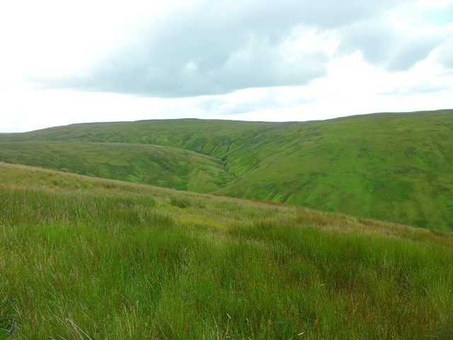
The surrounding area is rich in natural beauty, with heather-covered moorland, rocky outcrops, and scattered woodland. It is not uncommon to spot various species of wildlife, including birds of prey such as buzzards and kestrels, as well as deer and rabbits.

Overall, Cort-ma Law offers a rewarding outdoor experience with its accessible trails, breathtaking views, and diverse flora and fauna. It is a must-visit location for those seeking a taste of the Scottish countryside.

If you have any feedback on the listing, please let us know in the comments section below.

Cort-ma Law Images

Images are sourced within 2km of 55.993457/-4.1635786 or Grid Reference NS6579. Thanks to Geograph Open Source API. All images are credited.

East side of Lecket Hill Rough grassland around Boyd's Burn.
East side of Lecket Hill
Rough grassland around Boyd's Burn.
Moorland on Lecket Hill A broad ridge above Boyd's Burn with Meikle Bin beyond.
Moorland on Lecket Hill
A broad ridge above Boyd's Burn with Meikle Bin beyond.
Lecket Hill A broad ridge on the north side of the hill.
Lecket Hill
A broad ridge on the north side of the hill.
On Lecket Hill View towards the Carron Valley Reservoir.
On Lecket Hill
View towards the Carron Valley Reservoir.
On Lecket Hill View towards Meikle Bin from near the summit of Lecket Hill.
On Lecket Hill
View towards Meikle Bin from near the summit of Lecket Hill.
Cairn, Lecket Hill One of the candidates for summit. The top of Lecket Hill is a big flat area.
Cairn, Lecket Hill
One of the candidates for summit. The top of Lecket Hill is a big flat area.
On Lecket Hill View west from the summit area.
On Lecket Hill
View west from the summit area.
Westward view from Lecket Hill Towards the Campsie plateau on the other side of the Crow Road.
Westward view from Lecket Hill
Towards the Campsie plateau on the other side of the Crow Road.
Fence junction, Lecket Hill
Path on Lecket Hill A common route of ascent from the Crow Road. The stile is a bit flooded but the fence is in poor condition and low and could be stepped over.
Path on Lecket Hill
A common route of ascent from the Crow Road. The stile is a bit flooded but the fence is in poor condition and low and could be stepped over.
Moorland on the Campsie Fells Just north of Cort-ma-Law, looking to Meikle Bin.
Moorland on the Campsie Fells
Just north of Cort-ma-Law, looking to Meikle Bin.
Very boggy section of the Campsie Fells Just to the south of Lecket Hill.
Very boggy section of the Campsie Fells
Just to the south of Lecket Hill.
Summit of Lecket Hill Looking NE towards Carron Valley Reservoir, over the forest that surrounds Meikle Bin.
Summit of Lecket Hill
Looking NE towards Carron Valley Reservoir, over the forest that surrounds Meikle Bin.
Katrine's Burn, Campsie Fells Flowing into the Alnwick Burn.
Katrine's Burn, Campsie Fells
Flowing into the Alnwick Burn.
Boyd's Burn A well defined watercourse on the north side of Lecket Hill.
Boyd's Burn
A well defined watercourse on the north side of Lecket Hill.
Lecket Hill The southern slopes of Lecket Hill with some snow hanging on along the Whitestone Burn.
Lecket Hill
The southern slopes of Lecket Hill with some snow hanging on along the Whitestone Burn.
Moorland, Cort-ma Law Tussocky grassland around the headwaters of the Back Burn.
Moorland, Cort-ma Law
Tussocky grassland around the headwaters of the Back Burn.
Back Burn / Alnwick Burn A sinuous course with interlocking spurs. Holehead is in the background with the summit weather radar.
Back Burn / Alnwick Burn
A sinuous course with interlocking spurs. Holehead is in the background with the summit weather radar.
Show me another place!

Cort-ma Law is located at Grid Ref: NS6579 (Lat: 55.993457, Lng: -4.1635786)

Unitary Authority: East Dunbartonshire

Police Authority: Greater Glasgow

What 3 Words

///decorated.farmland.loans. Near Lennoxtown, East Dunbartonshire

Nearby Locations

Cort-ma Law

Related Wikis

Glorat

Glorat is a place and estate in the parish of Campsie in East Dunbartonshire, Scotland. == History == A towerhouse was built at Glorat in the 16th century...

Glorat House

Glorat House is a 19th-century mansion house in East Dunbartonshire, Scotland. It is located in Milton of Campsie, in the former county of Stirlingshire...

Meikle Bin

Meikle Bin is a peak in the Campsie Fells in Central Scotland. It is the second-highest of the group at 570 metres (1,870 ft), and with its prominence...

Lennoxtown (Old) railway station

Lennoxtown railway station served the town of Lennoxtown, Dunbartonshire, Scotland from 1848 to 1881 on the Blane Valley Railway. == History == The station...

Nearby Amenities

Located within 500m of 55.993457,-4.1635786
Cort Ma Law
Corbett: no
Donald: no
Ele: 531
Graham: no
Man Made: survey post
Munro: no
Natural: peak
Source: npe
Lat/Long: 55.9938465/-4.1634444
Ford: yes
Lat/Long: 55.9967463/-4.1673705
Ford: yes
Lat/Long: 55.9965453/-4.1655092
Ford: yes
Lat/Long: 55.9967321/-4.1612269
The data included in this document is from www.openstreetmap.org. The data is made available under ODbL.

Have you been to Cort-ma Law?

Leave your review of Cort-ma Law below (or comments, questions and feedback).