Holbeach Hurn

Settlement in Lincolnshire South Holland

England

Holbeach Hurn

The Bull at Fleet Hargate The village of Fleet Hargate formerly Fleet Harbourgate a small port
The Bull at Fleet Hargate Credit: Peter Latham

Holbeach Hurn is a small village located in the county of Lincolnshire, England. Situated near the town of Holbeach, Holbeach Hurn is a rural community with a population of around 200 residents. The village is known for its picturesque countryside surroundings, with fields and farmland stretching out in all directions.

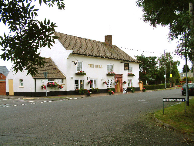
Holbeach Hurn is home to a number of historic buildings, including St. Peter's Church which dates back to the 13th century. The village also has a village hall, local pub, and a primary school, providing essential amenities for its residents.

The village is well-connected to the surrounding area, with good road links to nearby towns and cities such as Spalding and Peterborough. The landscape around Holbeach Hurn is predominantly agricultural, with many farms and fields producing crops such as vegetables and cereals.

Overall, Holbeach Hurn is a quiet and charming village, ideal for those looking for a peaceful rural retreat in the heart of the Lincolnshire countryside.

If you have any feedback on the listing, please let us know in the comments section below.

Holbeach Hurn Images

Images are sourced within 2km of 52.823525/0.069627 or Grid Reference TF3927. Thanks to Geograph Open Source API. All images are credited.

The Bull at Fleet Hargate The village of Fleet Hargate formerly Fleet Harbourgate a small port
The Bull at Fleet Hargate
The village of Fleet Hargate formerly Fleet Harbourgate a small port
Hamlet of Holbeach Hurn From the south
Hamlet of Holbeach Hurn
From the south
Hurn Road Looking west
Hurn Road
Looking west
Fields Close to Holbeach Hurn The flatlands of Holland (rather like its namesake) make for some great open sky panoramas.
Fields Close to Holbeach Hurn
The flatlands of Holland (rather like its namesake) make for some great open sky panoramas.
Church of St Luke, Holbeach Hurn Consecrated in 1869
Church of St Luke, Holbeach Hurn
Consecrated in 1869
Farmland adjacent to Crowmarsh Farm Fine Fenland soil in the field, pale in colour on this part of Holbeach Marsh. One of the wind turbines in <a href="https://www.geograph.org.uk/gridref/TF4229">TF4229</a> is clearly visible on the horizon.
Farmland adjacent to Crowmarsh Farm
Fine Fenland soil in the field, pale in colour on this part of Holbeach Marsh. One of the wind turbines in TF4229 is clearly visible on the horizon.
Garthside Farm Next to Coney Garth House which is hidden by the trees on the right.
Garthside Farm
Next to Coney Garth House which is hidden by the trees on the right.
Delivery box Saves the postman's legs!
At the entrance to Garthside Farm.
Delivery box
Saves the postman's legs! At the entrance to Garthside Farm.
Old sea bank at Coney Garth The road, Hurn Bank, follows the old 17th century sea bank; not clearly visible here as it's overgrown with weeds. See <span class="nowrap"><a title="http://www.visitthefens.co.uk/exec/136128/7651/PROFILE=NDpVS19VS1dFQjIyMTMxNDU6VUtfVUtXRUIxMTIzNDY1OkVOR0xJU0g6VVM6OjExODgyNDQ3Mzc6Ojo=" rel="nofollow ugc noopener" href="http://www.visitthefens.co.uk/exec/136128/7651/PROFILE=NDpVS19VS1dFQjIyMTMxNDU6VUtfVUtXRUIxMTIzNDY1OkVOR0xJU0g6VVM6OjExODgyNDQ3Mzc6Ojo=">Link</a><img style="margin-left:2px;" alt="External link" title="External link - shift click to open in new window" src="https://s1.geograph.org.uk/img/external.png" width="10" height="10"/></span>
Old sea bank at Coney Garth
The road, Hurn Bank, follows the old 17th century sea bank; not clearly visible here as it's overgrown with weeds. See LinkExternal link
View from Roman Bank The road into Holbeach Hurn is called Roman Bank and follows the old sea defence bank. You can see that the farmland is considerably lower than the bank immediately in front of the view point. A tall hedge follows the drain here, which acts as a windbreak. The farm machinery on the right looks as if it is lifting potatoes and there is a large JCB on the left carrying out drain maintenance. The wind farm in <a href="https://www.geograph.org.uk/gridref/TF4229">TF4229</a> is clearly visible on the horizon. The electricity pylon is in fact several kilometres in front of the turbines which just emphasizes how big they are: each one has an overall height of 100 metres and the rotors are 82 metres long, generating 2 megawatts of power.
View from Roman Bank
The road into Holbeach Hurn is called Roman Bank and follows the old sea defence bank. You can see that the farmland is considerably lower than the bank immediately in front of the view point. A tall hedge follows the drain here, which acts as a windbreak. The farm machinery on the right looks as if it is lifting potatoes and there is a large JCB on the left carrying out drain maintenance. The wind farm in TF4229 is clearly visible on the horizon. The electricity pylon is in fact several kilometres in front of the turbines which just emphasizes how big they are: each one has an overall height of 100 metres and the rotors are 82 metres long, generating 2 megawatts of power.
Roman Bank, Holbeach Hurn The houses on each side of Roman Bank, which follows the old sea bank, are considerably lower than the road.
Roman Bank, Holbeach Hurn
The houses on each side of Roman Bank, which follows the old sea bank, are considerably lower than the road.
Roman Bank, Holbeach Hurn Many of the houses along this village street have immaculately trimmed leylandii hedges.
Roman Bank, Holbeach Hurn
Many of the houses along this village street have immaculately trimmed leylandii hedges.
The Rose and Crown, Holbeach Hurn A small village pub on the junction of Low Road with Marsh Road.
The Rose and Crown, Holbeach Hurn
A small village pub on the junction of Low Road with Marsh Road.
From Low Road, Holbeach Hurn This is the field between Low Road and Marsh Road. The houses shown are on the southeast side of Marsh Road.
From Low Road, Holbeach Hurn
This is the field between Low Road and Marsh Road. The houses shown are on the southeast side of Marsh Road.
Notice, St Luke's Church Attached to the east door.
Notice, St Luke's Church
Attached to the east door.
West window, St Luke's Church Dedicated to the memory of Thomas Hovendworth RAF, who died in 1941.
West window, St Luke's Church
Dedicated to the memory of Thomas Hovendworth RAF, who died in 1941.
St Luke's Church, Holbeach Hurn This charming little brick church was built in 1869 for a cost of cost £697. The foundation stone was laid in August and it was consecrated on 23rd November following, the Chancel and Burial Ground were consecrated in March 1871. This photograph shows the west end and bell tower. See <a href="https://www.geograph.org.uk/photo/537739">TF3927 : Notice, St Luke's Church</a> for a sign in the porch giving information.
St Luke's Church, Holbeach Hurn
This charming little brick church was built in 1869 for a cost of cost £697. The foundation stone was laid in August and it was consecrated on 23rd November following, the Chancel and Burial Ground were consecrated in March 1871. This photograph shows the west end and bell tower. See TF3927 : Notice, St Luke's Church for a sign in the porch giving information.
Memorial window in St Luke's Church Dedicated to Peter Alaric Worth RAF killed in action 1942
Memorial window in St Luke's Church
Dedicated to Peter Alaric Worth RAF killed in action 1942
Show me another place!

Holbeach Hurn is located at Grid Ref: TF3927 (Lat: 52.823525, Lng: 0.069627)

Division: Parts of Holland

Administrative County: Lincolnshire

District: South Holland

Police Authority: Lincolnshire

What 3 Words

///redeemed.dress.freezing. Near Fleet, Lincolnshire

Nearby Locations

Holbeach Hurn

Related Wikis

Holbeach Hurn

Holbeach Hurn is a small fenland village in the civil parish of Holbeach in the South Holland district of southern Lincolnshire, England. It is 2.5 miles...

Gedney Dyke

Gedney Dyke is a village in the civil parish of Gedney and the South Holland district of Lincolnshire, England. It is 40 miles (64 km) south-east from...

Fleet Hargate

Fleet Hargate is a village in the South Holland district of Lincolnshire, England. It is situated 2 miles (3.2 km) east from Holbeach, and just south from...

Fleet railway station (Lincolnshire)

Fleet railway station was a station in Fleet, Lincolnshire. It opened in 1862 and closed to passengers in 1959, with the goods yard closing on 3 February...

Related Videos

Lawns & Lakes 1

Our first full day on site at the Lawns & Lakes campsite near Spalding in Lincolnshire.

Lawns & Lakes 3

A tour of the site. It's beautiful.

Lawns and Lakes Caravanning and Camping Park

Weekend Away 31st July - 3rd August 2020. Met many people and had many visitors had a terrific time.

We broke down

Heading towards our next holiday only to break down on the busy A421. Mayday!

Nearby Amenities

Located within 500m of 52.823525,0.069627
Holbeach Hurn
Is In: Lincolnshire, England, UK
Place: village
Wikidata: Q5878590
Lat/Long: 52.8236212/0.0663346
Bus Stop
Oakley Place
Naptan AtcoCode: 270000009638
Naptan Bearing: NE
Naptan CommonName: Oakley Place
Naptan Indicator: adj
Naptan Landmark: Oakley Place
Naptan NaptanCode: linjdmjd
Naptan Street: Marsh Road
Naptan Verified: no
Source: naptan_import
Lat/Long: 52.8254814/0.0686643
Bus Stop
Post Office
Naptan AtcoCode: 270000010556
Naptan Bearing: N
Naptan CommonName: Post Office
Naptan Indicator: opp
Naptan Landmark: Post Office
Naptan NaptanCode: linjmwjd
Naptan Street: Marsh Road
Naptan Verified: no
Source: naptan_import
Lat/Long: 52.8223847/0.0652667
Bus Stop
Post Office
Naptan AtcoCode: 270000010557
Naptan Bearing: S
Naptan CommonName: Post Office
Naptan Indicator: adj
Naptan Landmark: Post Office
Naptan NaptanCode: linjmwjg
Naptan Street: Marsh Road
Naptan Verified: no
Source: naptan_import
Lat/Long: 52.8223467/0.0653836
Bus Stop
Oakley Place
Naptan AtcoCode: 270000010558
Naptan Bearing: SW
Naptan CommonName: Oakley Place
Naptan Indicator: opp
Naptan Landmark: Oakley Place
Naptan NaptanCode: linjmwjm
Naptan Street: Marsh Road
Naptan Verified: no
Source: naptan_import
Lat/Long: 52.8252499/0.0685346
Bus Stop
Phoenix House
Naptan AtcoCode: 2700LHH06295
Naptan Bearing: NW
Naptan CommonName: Phoenix House
Naptan Indicator: adj
Naptan Landmark: Phoenix House
Naptan NaptanCode: lingawgt
Naptan Street: Hurn Bank
Naptan Verified: no
Source: naptan_import
Lat/Long: 52.8223057/0.0646396
Bus Stop
Bus Shelter
Naptan AtcoCode: 2700LHHH3614
Naptan Bearing: SE
Naptan CommonName: Bus Shelter
Naptan Indicator: adj
Naptan Landmark: Bus Shelter
Naptan NaptanCode: lindatmt
Naptan Street: Hurn Bank
Naptan Verified: no
Source: naptan_import
Lat/Long: 52.8223562/0.0648349
Post Box
Collection Times: Mo-Fr 16:40; Sa 08:00
Description: Against wall of cream colored house, opposite the start of Hurn Bank/Marsh Road / Hurn Bank / Roman Bank
Post Box Design: type_l
Post Box Type: lamp
Ref: PE12 98
Lat/Long: 52.822205/0.065328
Note: End of Public Highway
Lat/Long: 52.8260541/0.0756452
Power: pole
Lat/Long: 52.8199189/0.066808
Power: pole
Lat/Long: 52.819955/0.0688614
Power: pole
Lat/Long: 52.8199791/0.0704767
Power: pole
Lat/Long: 52.8200137/0.0723235
Power: pole
Lat/Long: 52.8200362/0.0739214
The data included in this document is from www.openstreetmap.org. The data is made available under ODbL.

Have you been to Holbeach Hurn?

Leave your review of Holbeach Hurn below (or comments, questions and feedback).