Hartland Tor

Hill, Mountain in Devon West Devon

England

Hartland Tor

Ruined farmhouse near Stannon Tor Scale 2m <span class="nowrap"><a title="https://www.heritagegateway.org.uk/Gateway/Results_Single.aspx?uid=MDV15310&resourceID=104" rel="nofollow ugc noopener" href="https://www.heritagegateway.org.uk/Gateway/Results_Single.aspx?uid=MDV15310&resourceID=104">Link</a><img style="margin-left:2px;" alt="External link" title="External link - shift click to open in new window" src="https://s1.geograph.org.uk/img/external.png" width="10" height="10"/></span>
Ruined farmhouse near Stannon Tor Credit: Sandy Gerrard

Hartland Tor is a prominent hill located in the county of Devon, England. Situated on the northwestern edge of Dartmoor National Park, it stands at an elevation of approximately 384 meters (1,260 feet) above sea level. The tor is part of a range of hills known as the Hartland Moor Hills, which stretch across the region.

Hartland Tor offers breathtaking panoramic views of the surrounding countryside, including the sprawling moorland, dense woodlands, and the distant coastline. It is a popular destination for hikers and nature enthusiasts who are drawn to its natural beauty and tranquility.

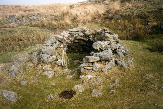
The tor itself is characterized by its rocky outcrops and rugged terrain, which make it a fascinating geological feature. The rocks are primarily composed of granite, a common element in Dartmoor's landscape. The tor's distinctive shape and elevation make it easily recognizable from a distance.

The area surrounding Hartland Tor is rich in wildlife, with various species of birds, mammals, and plants inhabiting the hills and moorland. Visitors may spot buzzards soaring overhead, Dartmoor ponies grazing on the grassy slopes, or even the elusive adders basking in the sun. The diverse flora and fauna contribute to the tor's ecological significance.

Hartland Tor is easily accessible by foot, with several footpaths leading to its summit. It provides an excellent opportunity for outdoor activities such as hiking, photography, and birdwatching. Its beauty and natural allure make Hartland Tor a must-visit destination for those exploring the scenic landscapes of Devon.

If you have any feedback on the listing, please let us know in the comments section below.

Hartland Tor Images

Images are sourced within 2km of 50.60372/-3.9204271 or Grid Reference SX6479. Thanks to Geograph Open Source API. All images are credited.

Ruined farmhouse near Stannon Tor Scale 2m <span class="nowrap"><a title="https://www.heritagegateway.org.uk/Gateway/Results_Single.aspx?uid=MDV15310&resourceID=104" rel="nofollow ugc noopener" href="https://www.heritagegateway.org.uk/Gateway/Results_Single.aspx?uid=MDV15310&resourceID=104">Link</a><img style="margin-left:2px;" alt="External link" title="External link - shift click to open in new window" src="https://s1.geograph.org.uk/img/external.png" width="10" height="10"/></span>
Ruined farmhouse near Stannon Tor
Scale 2m LinkExternal link
Beehive hut in Great Stannon Newtake Scale 1m <span class="nowrap"><a title="https://historicengland.org.uk/listing/the-list/list-entry/1019266?section=official-list-entry" rel="nofollow ugc noopener" href="https://historicengland.org.uk/listing/the-list/list-entry/1019266?section=official-list-entry">Link</a><img style="margin-left:2px;" alt="External link" title="External link - shift click to open in new window" src="https://s1.geograph.org.uk/img/external.png" width="10" height="10"/></span>
Beehive hut in Great Stannon Newtake
Scale 1m LinkExternal link
Postbridge - Post Office Stores Village shop with post office, close to Postbridge's famous clapper bridge.
<span class="nowrap"><a title="www.dartmoor.gov.uk" rel="nofollow ugc noopener" href="http://www.dartmoor.gov.uk">Link</a><img style="margin-left:2px;" alt="External link" title="External link - shift click to open in new window" src="https://s1.geograph.org.uk/img/external.png" width="10" height="10"/></span>
Postbridge - Post Office Stores
Village shop with post office, close to Postbridge's famous clapper bridge. LinkExternal link
Postbridge - Clapper Bridge "Postbridge's famous clapper bridge is believed to be medieval and would probably have replaced stepping stones to help pack horses cross the East Dart River. The bridge has two central piers spanned by three large granite slabs, or clappers.
The word clapper is thought to derive from the Anglo-Saxon word ‘cleaca’, meaning stepping stones".
<span class="nowrap"><a title="www.dartmoor.gov.uk" rel="nofollow ugc noopener" href="http://www.dartmoor.gov.uk">Link</a><img style="margin-left:2px;" alt="External link" title="External link - shift click to open in new window" src="https://s1.geograph.org.uk/img/external.png" width="10" height="10"/></span>
Postbridge - Clapper Bridge
"Postbridge's famous clapper bridge is believed to be medieval and would probably have replaced stepping stones to help pack horses cross the East Dart River. The bridge has two central piers spanned by three large granite slabs, or clappers. The word clapper is thought to derive from the Anglo-Saxon word ‘cleaca’, meaning stepping stones". LinkExternal link
Postbridge - New Bridge The new bridge was built in the 1770s to carry the turnpike road across the East Dart River. It bypasses the medieval clapper bridge.
<span class="nowrap"><a title="www.dartmoor.gov.uk" rel="nofollow ugc noopener" href="http://www.dartmoor.gov.uk">Link</a><img style="margin-left:2px;" alt="External link" title="External link - shift click to open in new window" src="https://s1.geograph.org.uk/img/external.png" width="10" height="10"/></span>
Postbridge - New Bridge
The new bridge was built in the 1770s to carry the turnpike road across the East Dart River. It bypasses the medieval clapper bridge. LinkExternal link
Prehistoric round house at Kraps Ring (Scale 1m) <span class="nowrap"><a title="https://historicengland.org.uk/listing/the-list/list-entry/1018509?section=official-listing" rel="nofollow ugc noopener" href="https://historicengland.org.uk/listing/the-list/list-entry/1018509?section=official-listing">Link</a><img style="margin-left:2px;" alt="External link" title="External link - shift click to open in new window" src="https://s1.geograph.org.uk/img/external.png" width="10" height="10"/></span>
Prehistoric round house at Kraps Ring
(Scale 1m) LinkExternal link
A view of Dartmoor across Postbridge
Broadun Bronze Age Settlement View from Chittaford Down <span class="nowrap"><a title="https://historicengland.org.uk/listing/the-list/list-entry/1021333?section=official-list-entry" rel="nofollow ugc noopener" href="https://historicengland.org.uk/listing/the-list/list-entry/1021333?section=official-list-entry">Link</a><img style="margin-left:2px;" alt="External link" title="External link - shift click to open in new window" src="https://s1.geograph.org.uk/img/external.png" width="10" height="10"/></span>
Broadun Bronze Age Settlement
View from Chittaford Down LinkExternal link
The East Dart River at Postbridge
Dartmoor near Powdermills
Grazing land near Postbridge
Track to Fair Holm
Track to Fair Holm
Greyhound Cottage, Postbridge
Show me another place!

Hartland Tor is located at Grid Ref: SX6479 (Lat: 50.60372, Lng: -3.9204271)

Administrative County: Devon

District: West Devon

Police Authority: Devon and Cornwall

What 3 Words

///pinging.flickers.craftsmen. Near Princetown, Devon

Nearby Locations

Hartland Tor

Related Wikis

Postbridge

Postbridge is a hamlet in the heart of Dartmoor in the English county of Devon. It lies on the B3212, roughly midway between Princetown and Moretonhampstead...

Dartmoor Forest

Dartmoor Forest is a civil parish in Devon, England. It was formed in 1987 by the splitting of the former parish of Lydford. It covers about 56,000 acres...

Bellever

Bellever is a hamlet in Dartmoor, Devon, England. It is located on the river East Dart about 2 kilometres (1 mi) south of Postbridge. The first mention...
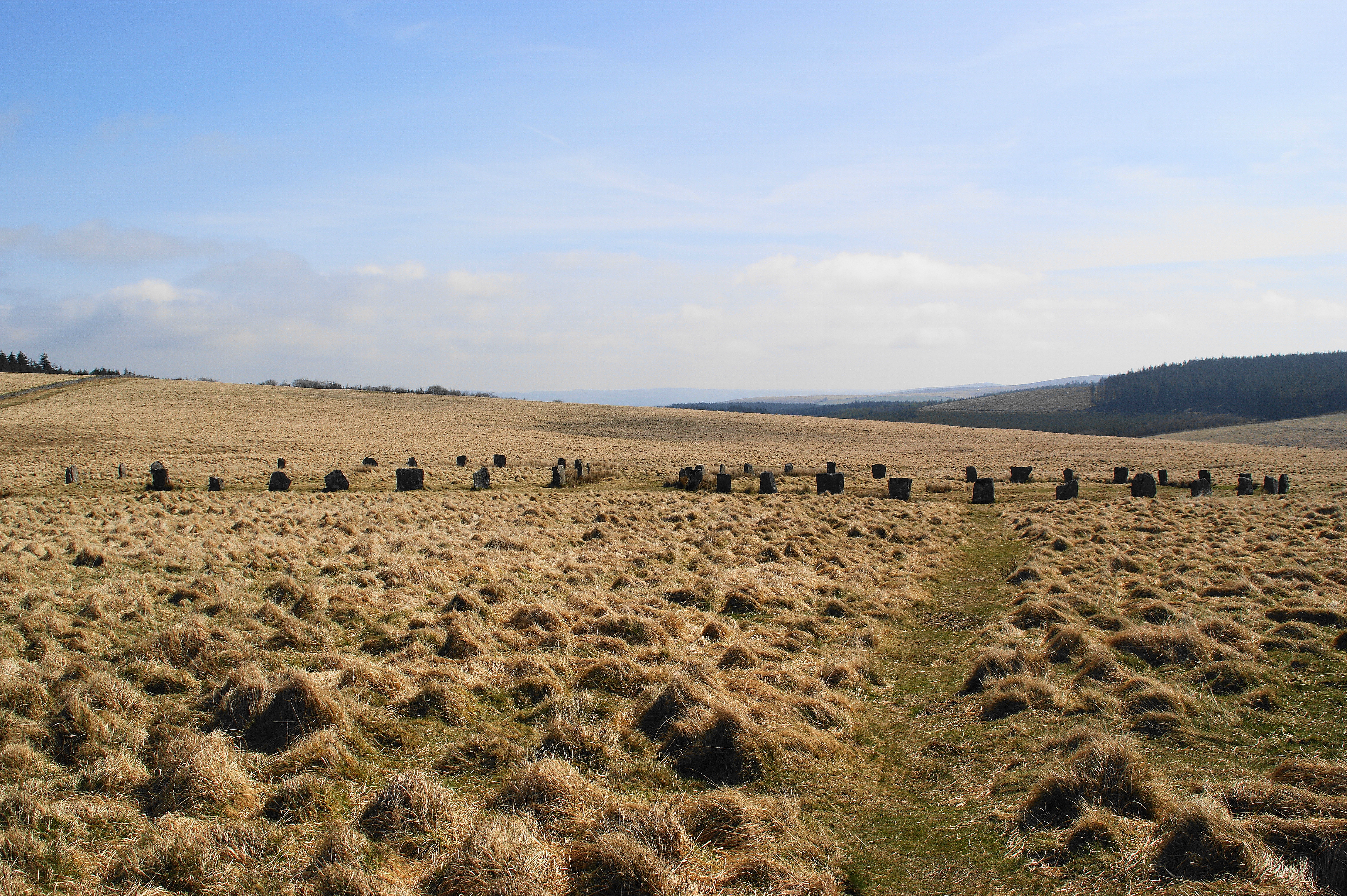
Grey Wethers

Grey Wethers consists of a pair of prehistoric stone circles, situated on grassy plateau to the north of Postbridge, Dartmoor, in the United Kingdom....

Nearby Amenities

Located within 500m of 50.60372,-3.9204271
Hartland Tor
Natural: peak
Source: NPE
Lat/Long: 50.6033026/-3.9205394
The data included in this document is from www.openstreetmap.org. The data is made available under ODbL.

Have you been to Hartland Tor?

Leave your review of Hartland Tor below (or comments, questions and feedback).