Beinn Ghlas

Hill, Mountain in Perthshire

Scotland

Beinn Ghlas

Toposcope on Ben Lawers
Toposcope on Ben Lawers Credit: Steven Brown

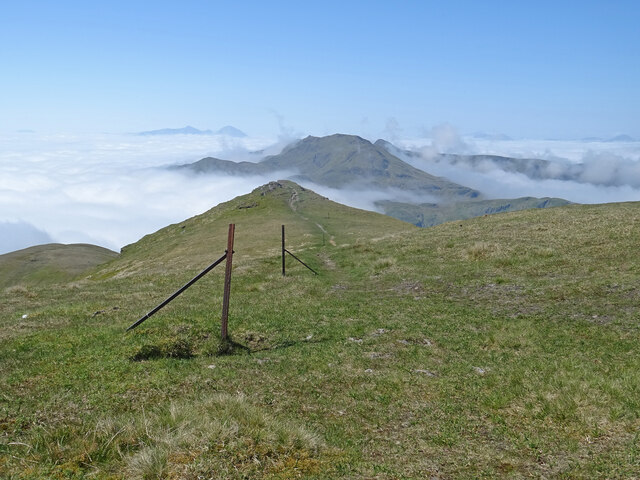
Beinn Ghlas is a prominent hill located in Perthshire, Scotland. It is part of the Ben Lawers range and is situated near the popular tourist destination of Loch Tay. Standing at an impressive height of 3,615 feet (1,102 meters), Beinn Ghlas offers stunning panoramic views of the surrounding area, including the nearby mountains and valleys.

The hill is a popular destination for hikers and outdoor enthusiasts, with a well-defined path leading to the summit. The hike to the top of Beinn Ghlas can be challenging, but the breathtaking views from the top make it well worth the effort.

Beinn Ghlas is known for its diverse flora and fauna, with a variety of plant species and wildlife inhabiting the hillside. The area is also home to several rare and endangered species, making it a valuable conservation site.

Overall, Beinn Ghlas is a beautiful and rugged hill that offers a rewarding hiking experience for those willing to make the trek to the summit. Its natural beauty and stunning views make it a must-visit destination for nature lovers and outdoor enthusiasts in Perthshire.

If you have any feedback on the listing, please let us know in the comments section below.

Beinn Ghlas Images

Images are sourced within 2km of 56.536016/-4.2370267 or Grid Reference NN6240. Thanks to Geograph Open Source API. All images are credited.

Toposcope on Ben Lawers
Path up Bheinn Ghlas
Path up Meall Corranaich
Summit of Beinn Ghlas Small pile of stones marking the summit of Beinn Ghlas, viewed from the south-west.
Summit of Beinn Ghlas
Small pile of stones marking the summit of Beinn Ghlas, viewed from the south-west.
Summit of Ben Lawers The summit area of Ben Lawers, with the damaged triangulation pillar and cairn.
Summit of Ben Lawers
The summit area of Ben Lawers, with the damaged triangulation pillar and cairn.
Valley below Meall Corranaich Looking west from the Ben Lawers path into the valley below the eastern flank of Meall Corranaich.
Valley below Meall Corranaich
Looking west from the Ben Lawers path into the valley below the eastern flank of Meall Corranaich.
Summit of Meall Corranaich Looking eastwards to the small cairn marking the summit of Meall Corranaich, with An Stuc and a partly cloud ridden Ben Lawers beyond.
Summit of Meall Corranaich
Looking eastwards to the small cairn marking the summit of Meall Corranaich, with An Stuc and a partly cloud ridden Ben Lawers beyond.
Ben Lawers Path Heading down the Ben Lawers path under the western flank of Beinn Ghlas, with Stob Binnein and Ben More on the horizon to the right.
Ben Lawers Path
Heading down the Ben Lawers path under the western flank of Beinn Ghlas, with Stob Binnein and Ben More on the horizon to the right.
Lunch with a View What a place for lunch - these 3 climbers are enjoying a well earned rest and snack on the summit of Ben Lawers. You can see the other 3 mountains of An Stuc, Meall Garbh and Meall Greigh that make up the fine circuit round Lochan nan Cat from Lawers. The east end of Loch Tay can also be seen.
Lunch with a View
What a place for lunch - these 3 climbers are enjoying a well earned rest and snack on the summit of Ben Lawers. You can see the other 3 mountains of An Stuc, Meall Garbh and Meall Greigh that make up the fine circuit round Lochan nan Cat from Lawers. The east end of Loch Tay can also be seen.
Beinn Ghlas Cloud Inversion Magnificent cloud inversion as seen from the summit ridge of Beinn Ghlas. Only the Munros are poking through the cloud. A grand day to be in the mountains.
Beinn Ghlas Cloud Inversion
Magnificent cloud inversion as seen from the summit ridge of Beinn Ghlas. Only the Munros are poking through the cloud. A grand day to be in the mountains.
Beinn Ghlas Summit View Looking towards Ben Lawers from the summit of Beinn Ghlas. Partial cloud inversion in the valley, which was much more complete in the south and west.
Beinn Ghlas Summit View
Looking towards Ben Lawers from the summit of Beinn Ghlas. Partial cloud inversion in the valley, which was much more complete in the south and west.
Which Way Now? On the summit of Beinn Ghlas and the 2 terriers look like they will head off in opposite directions! Ben Lawers is in the centre, but we are in fact heading towards Meall Corranaich, well off to the left of picture.
Which Way Now?
On the summit of Beinn Ghlas and the 2 terriers look like they will head off in opposite directions! Ben Lawers is in the centre, but we are in fact heading towards Meall Corranaich, well off to the left of picture.
Into the Valley Climbing the Munro of Meall Corranaich and we are above the cloud in the valley of the Allt a' Chobhair.  Ben Lawers and An Stuc are the 2 prominent hills seen above the cloud.
Into the Valley
Climbing the Munro of Meall Corranaich and we are above the cloud in the valley of the Allt a' Chobhair. Ben Lawers and An Stuc are the 2 prominent hills seen above the cloud.
Old Fence, Meall Corranaich Glorious day in the Scottish Highlands. An old fence on the summit of Meall Corranaich leads the eye to the far hills and valley cloud inversion.
Old Fence, Meall Corranaich
Glorious day in the Scottish Highlands. An old fence on the summit of Meall Corranaich leads the eye to the far hills and valley cloud inversion.
Looking over to the ridge Looking west over the Burn of Edramucky to the end of the knobbly ridge that extends south from Meall Corranaich, with Meall nan Tarmachan beyond.
Looking over to the ridge
Looking west over the Burn of Edramucky to the end of the knobbly ridge that extends south from Meall Corranaich, with Meall nan Tarmachan beyond.
Steep hydro culvert
Steep hydro culvert
All Becomes Clear On the south-west ridge of Beinn Ghlas and at c750m we have come out of the clag and into a different world. Set off from the car park with a waterproof on and now it's taps aff weather! Hill in the centre is Meall Corranaich.
All Becomes Clear
On the south-west ridge of Beinn Ghlas and at c750m we have come out of the clag and into a different world. Set off from the car park with a waterproof on and now it's taps aff weather! Hill in the centre is Meall Corranaich.
Peaks Above The Clouds On the slopes of Beinn Ghlas and in the distance only the bigger peaks are showing through a valley inversion. Stunning conditions in the Scottish Highlands. In the far distance are Stob Binnean and Ben More, middle distance is Meall nan Tarmachan and to the right is Meall Ghaordaidh.
Peaks Above The Clouds
On the slopes of Beinn Ghlas and in the distance only the bigger peaks are showing through a valley inversion. Stunning conditions in the Scottish Highlands. In the far distance are Stob Binnean and Ben More, middle distance is Meall nan Tarmachan and to the right is Meall Ghaordaidh.
Show me another place!

Beinn Ghlas is located at Grid Ref: NN6240 (Lat: 56.536016, Lng: -4.2370267)

Unitary Authority: Perth and Kinross

Police Authority: Tayside

What 3 Words

///fastening.tens.plastic. Near Pubil, Perth & Kinross

Nearby Locations

Beinn Ghlas

Related Wikis

Beinn Ghlas

Beinn Ghlas is a mountain in the Breadalbane region of the Scottish Highlands. It lies on the north shore of Loch Tay and is part of the Ben Lawers Range...

Meall Corranaich

Meall Corranaich (Scottish Gaelic: Meall Choire Inich) is a mountain with a height of 1,069 metres (3,507 ft) in the Grampian Mountains of Scotland. It...

Ben Lawers

Ben Lawers (Scottish Gaelic: Beinn Labhair) is the highest mountain in the Breadalbane region of the Scottish Highlands. It lies north of Loch Tay and...

An Stùc

An Stùc, meaning "The Peak" in Gaelic, is a conically shaped Scottish mountain in the Ben Lawers range to the north of Loch Tay. It has been listed as...

Nearby Amenities

Located within 500m of 56.536016,-4.2370267
Beinn Ghlas
Description: Greenish-grey hill
Ele: 1103
Munro: yes
Munro Number: M047
Natural: peak
Wikidata: Q3399686
Wikipedia: en:Beinn Ghlas
Lat/Long: 56.5360003/-4.2370429
The data included in this document is from www.openstreetmap.org. The data is made available under ODbL.

Have you been to Beinn Ghlas?

Leave your review of Beinn Ghlas below (or comments, questions and feedback).