Rough Tor

Hill, Mountain in Devon West Devon

England

Rough Tor

Cist and Capstone near Crow Tor (Scale 1m) <span class="nowrap"><a title="https://historicengland.org.uk/listing/the-list/list-entry/1016922?section=official-listing" rel="nofollow ugc noopener" href="https://historicengland.org.uk/listing/the-list/list-entry/1016922?section=official-listing">Link</a><img style="margin-left:2px;" alt="External link" title="External link - shift click to open in new window" src="https://s1.geograph.org.uk/img/external.png" width="10" height="10"/></span>
Cist and Capstone near Crow Tor Credit: Sandy Gerrard

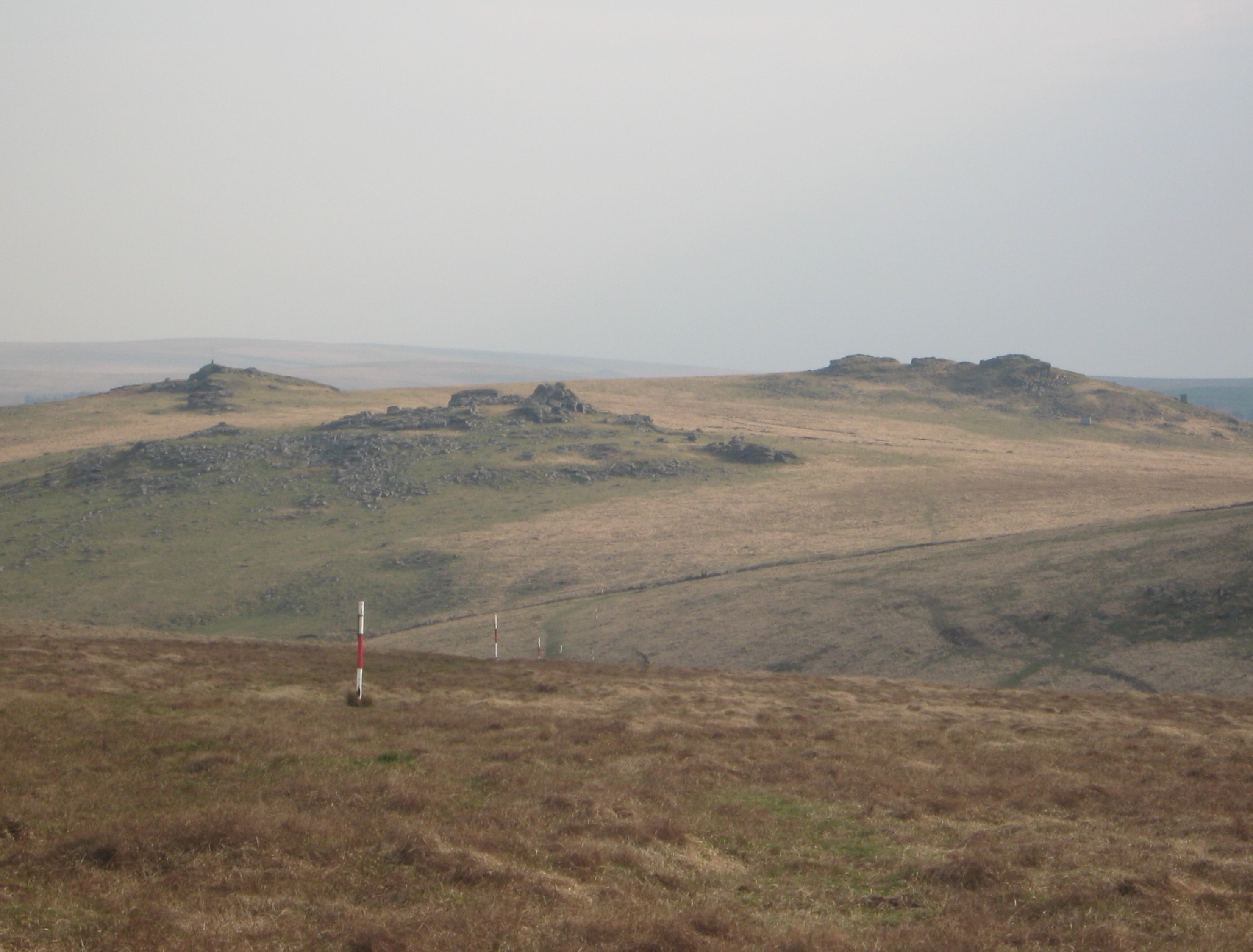
Rough Tor, located in the county of Devon, is a prominent hill known for its rugged and picturesque landscape. Situated in the southwestern part of England, Rough Tor is part of the Bodmin Moor, a designated Area of Outstanding Natural Beauty. Rising to an elevation of approximately 1313 feet (400 meters), it is often referred to as a mountain due to its impressive stature.

The hill is composed of rough granite, which gives it its distinctive name. Its exposed and weathered surface creates a unique and captivating scenery, attracting visitors from near and far. Rough Tor offers breathtaking panoramic views of the surrounding countryside, including rolling hills, deep valleys, and scattered tors, which are rocky outcrops commonly found in this area.

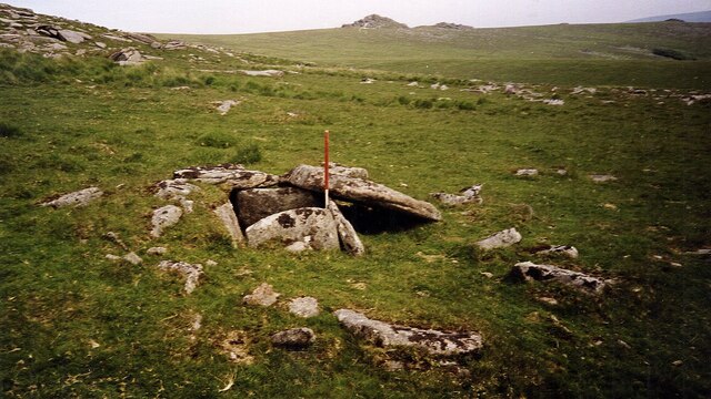
The hill is also notable for its historical significance. It features an ancient burial chamber known as the "Cheesewring," a prehistoric monument consisting of a series of stacked granite stones. This site has captivated the imagination of many, as its purpose and origins remain a subject of debate among archaeologists and historians.

Due to its natural beauty and archaeological importance, Rough Tor is a popular destination for hikers, nature enthusiasts, and history buffs. Several walking trails wind their way up the hill, allowing visitors to explore its diverse flora and fauna while immersing themselves in the rich history of the area.

Overall, Rough Tor in Devon offers a captivating blend of natural beauty, historical intrigue, and outdoor adventure, making it a must-visit destination for those seeking a unique and enriching experience in the heart of southwestern England.

If you have any feedback on the listing, please let us know in the comments section below.

Rough Tor Images

Images are sourced within 2km of 50.601434/-3.9710667 or Grid Reference SX6079. Thanks to Geograph Open Source API. All images are credited.

Cist and Capstone near Crow Tor (Scale 1m) <span class="nowrap"><a title="https://historicengland.org.uk/listing/the-list/list-entry/1016922?section=official-listing" rel="nofollow ugc noopener" href="https://historicengland.org.uk/listing/the-list/list-entry/1016922?section=official-listing">Link</a><img style="margin-left:2px;" alt="External link" title="External link - shift click to open in new window" src="https://s1.geograph.org.uk/img/external.png" width="10" height="10"/></span>
Cist and Capstone near Crow Tor
(Scale 1m) LinkExternal link
Cairn and cist near Crow Tor (Scale 1m) <span class="nowrap"><a title="https://historicengland.org.uk/listing/the-list/list-entry/1016922?section=official-listing" rel="nofollow ugc noopener" href="https://historicengland.org.uk/listing/the-list/list-entry/1016922?section=official-listing">Link</a><img style="margin-left:2px;" alt="External link" title="External link - shift click to open in new window" src="https://s1.geograph.org.uk/img/external.png" width="10" height="10"/></span>
Cairn and cist near Crow Tor
(Scale 1m) LinkExternal link
Below Cowsic Head
Below Cowsic Head
Lydford Tor
Lydford Tor
Stile and Boundary, Lydford Tor
Granite Outcrop Near Devil's Tor
Beardown Man A Bronze Age standing stone.
Beardown Man
A Bronze Age standing stone.
Moorland, Maiden Hill
Conies Down Tor
Conies Down Tor
Cowsic Head - Dartmoor A small peat hag above Cowsic Head. Great Mis Tor on the horizon.
Cowsic Head - Dartmoor
A small peat hag above Cowsic Head. Great Mis Tor on the horizon.
Remains of tinner's hut Marked on the OS 1:25000 map but almost unrecognisable on the ground.
Remains of tinner's hut
Marked on the OS 1:25000 map but almost unrecognisable on the ground.
Spot height 563 Looking northwards across featureless peat moorland, Fur Tor is just visible on the horizon.
Spot height 563
Looking northwards across featureless peat moorland, Fur Tor is just visible on the horizon.
Cowsic Head The source of the River Cowsic, after a period of dry weather.
Cowsic Head
The source of the River Cowsic, after a period of dry weather.
Cowsic River Looking upstream north of the junction with Conies Down Water.
Cowsic River
Looking upstream north of the junction with Conies Down Water.
Cow's skull above the Cowsic Someone's idea of a prank; the skull of a cow has been placed on top of a prominent rock close to the Cowsic River.
Cow's skull above the Cowsic
Someone's idea of a prank; the skull of a cow has been placed on top of a prominent rock close to the Cowsic River.
Sheep by the Cowsic River There was a lamb there somewhere but it seems to have got itself hidden behind one of the ewes. This is the upper valley of the Cowsic, here a modest stream.
Sheep by the Cowsic River
There was a lamb there somewhere but it seems to have got itself hidden behind one of the ewes. This is the upper valley of the Cowsic, here a modest stream.
Upper valley of the Cowsic Cowsic Head is nearly a kilometre further north from the camera, but here the stream, joined by a couple of headwaters on the left, enters a deep valley for the first time.
Upper valley of the Cowsic
Cowsic Head is nearly a kilometre further north from the camera, but here the stream, joined by a couple of headwaters on the left, enters a deep valley for the first time.
Upper valley of the Cowsic Looking down the valley from the same spot as <a href="https://www.geograph.org.uk/photo/2417520">SX5979 : Upper valley of the Cowsic</a>.
Upper valley of the Cowsic
Looking down the valley from the same spot as SX5979 : Upper valley of the Cowsic.
Show me another place!

Rough Tor is located at Grid Ref: SX6079 (Lat: 50.601434, Lng: -3.9710667)

Administrative County: Devon

District: West Devon

Police Authority: Devon and Cornwall

What 3 Words

///sues.agrees.moisture. Near Princetown, Devon

Nearby Locations

Rough Tor

Related Wikis

Roman Catholic Diocese of Plymouth

The Diocese of Plymouth(Latin: Dioecesis Plymuthensis) is a Latin Church diocese of the Catholic Church in England. The episcopal see is in the city of...

Dartmoor Forest

Dartmoor Forest is a civil parish in Devon, England. It was formed in 1987 by the splitting of the former parish of Lydford. It covers about 56,000 acres...

Devonport Leat

The Devonport Leat is a leat in Devon constructed in the 1790s to carry fresh drinking water from the high ground of Dartmoor to the expanding dockyards...

Beardown Tors

Beardown Tors is the 14th highest summit of Dartmoor with a height of 513 metres (1,683 ft). == References == OS OL20 Map Beardown Tors-Mountains Britain

Wistman's Wood

Wistman's Wood is one of three remote high-altitude oakwoods on Dartmoor in Devon, England. == Geography == The wood lies at an altitude of 380–410 metres...

Crockern Tor

Crockern Tor is a tor in Dartmoor National Park, Devon, England. Composed of two large outcrops of rock, it is 396 metres above sea level. The lower outcrop...

Postbridge

Postbridge is a hamlet in the heart of Dartmoor in the English county of Devon. It lies on the B3212, roughly midway between Princetown and Moretonhampstead...

Dartmoor

Dartmoor is an upland area in southern Devon, South West England. The moorland and surrounding land has been protected by National Park status since 1951...

Nearby Amenities

Located within 500m of 50.601434,-3.9710667
Rough Tor
Ele: 546
Natural: peak
Source: NPE
Lat/Long: 50.6014375/-3.9710959
Ford: stepping_stones
Lat/Long: 50.6032398/-3.9655835
Natural: spring
Lat/Long: 50.5990407/-3.9748236
Field Telephone Connection
Access: private
Description: Military field telephone connection socket on exterior wall of OP hut.
Man Made: telephone
Military: field_telephone
Operator: Ministry of Defence
Ref: Rough Tor
Usage: military
Website: https://webarchive.nationalarchives.gov.uk/20121026065214/http://www.mod.uk/NR/rdonlyres/EBF59C8C-8B0E-4349-B40B-B6566B658959/0/Okehampton_Artillery_Range_Observation_Posts.pdf
Lat/Long: 50.6014877/-3.9710948
Range Warning Flagpole
Flag Type: signal
Height: 6
Man Made: flagpole
Operator: Ministry of Defence
Ref: Rough Tor
Website: https://webarchive.nationalarchives.gov.uk/20121026065214/http://www.mod.uk/NR/rdonlyres/EBF59C8C-8B0E-4349-B40B-B6566B658959/0/Okehampton_Artillery_Range_Observation_Posts.pdf
Lat/Long: 50.6015551/-3.9709522
The data included in this document is from www.openstreetmap.org. The data is made available under ODbL.

Have you been to Rough Tor?

Leave your review of Rough Tor below (or comments, questions and feedback).