Beinn Bhoidheach

Hill, Mountain in Perthshire

Scotland

Beinn Bhoidheach

Burn system on southern slopes of Beinn Bhoidheach The lochan is entirely separate from the burn system and appears to have no overground inlet or outle.
Burn system on southern slopes of Beinn Bhoidheach Credit: ian shiell

Beinn Bhoidheach, located in Perthshire, Scotland, is a stunning hill/mountain that offers breathtaking views and a variety of outdoor activities for nature enthusiasts. With an elevation of 720 meters (2,362 feet), it stands as an impressive landmark in the region.

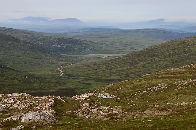
The hill/mountain is characterized by its rugged and rocky terrain, covered in heather and scattered with boulders. Its slopes are home to diverse fauna and flora, including wildflowers, birds, and small mammals, creating a vibrant ecosystem.

One of the primary attractions of Beinn Bhoidheach is its panoramic views. From its summit, visitors can gaze upon the surrounding Perthshire countryside, taking in the beauty of the rolling hills, sparkling lochs, and dense forests. On clear days, even distant mountains such as Ben Nevis can be spotted.

Hiking and walking are popular activities on Beinn Bhoidheach, with several trails and paths available for all skill levels. The ascent to the summit can be challenging, but the rewarding vistas make it worthwhile. Along the way, walkers may come across ancient ruins, stone circles, and other remnants of Scotland's rich history.

Due to its remote location, Beinn Bhoidheach provides a peaceful and tranquil environment, allowing visitors to reconnect with nature and escape the hustle and bustle of everyday life. It is a perfect destination for those seeking solitude and a chance to immerse themselves in the natural beauty of Perthshire.

Overall, Beinn Bhoidheach is a magnificent hill/mountain that offers both a physical challenge and a visual feast for those who venture to its summit. It is a must-visit destination for outdoor enthusiasts and nature lovers in search of stunning landscapes and a sense of tranquility.

If you have any feedback on the listing, please let us know in the comments section below.

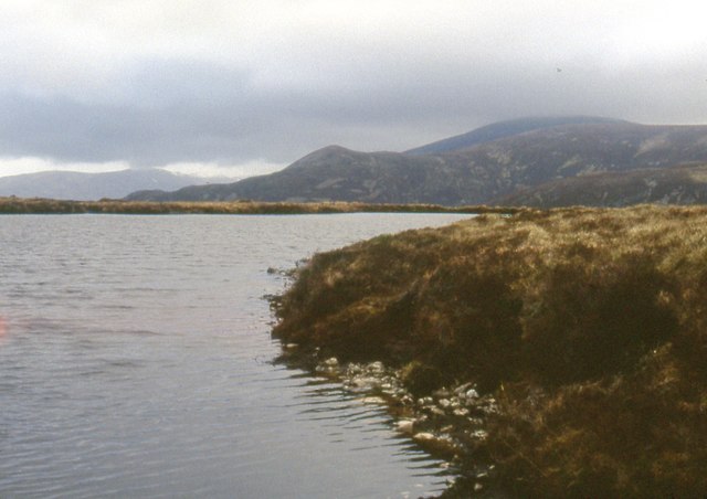
Beinn Bhoidheach Images

Images are sourced within 2km of 56.759655/-4.3454526 or Grid Reference NN5665. Thanks to Geograph Open Source API. All images are credited.

Burn system on southern slopes of Beinn Bhoidheach The lochan is entirely separate from the burn system and appears to have no overground inlet or outle.
Burn system on southern slopes of Beinn Bhoidheach
The lochan is entirely separate from the burn system and appears to have no overground inlet or outle.
Lochan on Glas Meall Mòr Beinn Udlamain in the clouds.
Lochan on Glas Meall Mòr
Beinn Udlamain in the clouds.
Beinn Mholach Trig Pillar The view west to Ben Alder.
Beinn Mholach Trig Pillar
The view west to Ben Alder.
Boggy ground W of Beinn Bhoidheach
Summit of Beinn Bhoidheach With Beinn Mholach on the left and Schiehallion on the right
Summit of Beinn Bhoidheach
With Beinn Mholach on the left and Schiehallion on the right
Boggy ground E of Beinn Bhoidheach
Moorland S of Beinn Bhoidheach Schiehallion is on the left
Moorland S of Beinn Bhoidheach
Schiehallion is on the left
Moorland SW of Beinn Bhoidheach Looking towards Schiehallion
Moorland SW of Beinn Bhoidheach
Looking towards Schiehallion
Allt Cro-Chloich valley Looking down the Allt Cro-Chloich valley on a snowy overcast day. A featureless area of heather moorland with a few crags, this valley is just to the north-west of Beinn Mholach.
Allt Cro-Chloich valley
Looking down the Allt Cro-Chloich valley on a snowy overcast day. A featureless area of heather moorland with a few crags, this valley is just to the north-west of Beinn Mholach.
Snow and ice on the Allt Cro-Chloich Overhanging banks of snow and lines of icicles adorn the upper reaches of the Allt Cro-Chloich on a winter's day.
Snow and ice on the Allt Cro-Chloich
Overhanging banks of snow and lines of icicles adorn the upper reaches of the Allt Cro-Chloich on a winter's day.
Summit of Glas Meall Mòr A view from the summit of Summit of Glas Meall Mòr, with the course of the Allt Shallain  - my return route - visible in the centre of the image. After several days of hot weather much of the ground - usually bog - is now tinder dry, and the upper region of many watercourses have completely dried out.
Summit of Glas Meall Mòr
A view from the summit of Summit of Glas Meall Mòr, with the course of the Allt Shallain - my return route - visible in the centre of the image. After several days of hot weather much of the ground - usually bog - is now tinder dry, and the upper region of many watercourses have completely dried out.
Meallanan Odhar Moorland on Meallanan Odhar, with Loch Rannoch visible in the distance.
Meallanan Odhar
Moorland on Meallanan Odhar, with Loch Rannoch visible in the distance.
South west of Glas Mheall Mòr A view towards the Allt Crò-Chloich taken from high ground south west of the summit of Glas Mheall Mòr. Schiehallion can be seen on the skyline, a prominent landmark from many areas of central Scotland.
South west of Glas Mheall Mòr
A view towards the Allt Crò-Chloich taken from high ground south west of the summit of Glas Mheall Mòr. Schiehallion can be seen on the skyline, a prominent landmark from many areas of central Scotland.
Allt Crò-Chloich The Allt Crò-Chloich, a tributary of the Allt Shallain. This burn is almost dry, little more than a series of pools in many places, after several days of unusually warm weather in central Scotland.
Allt Crò-Chloich
The Allt Crò-Chloich, a tributary of the Allt Shallain. This burn is almost dry, little more than a series of pools in many places, after several days of unusually warm weather in central Scotland.
Pt.742m, Beinn Bhoidheach The hill in the background is Beinn Mholach, a remote Corbett.
Pt.742m, Beinn Bhoidheach
The hill in the background is Beinn Mholach, a remote Corbett.
S Flank of Beinn Bhoidheach Peat hags and the odd rock are all that there is in this grid square. The distant peak of Schiehallion, however, gives interest to the view.
S Flank of Beinn Bhoidheach
Peat hags and the odd rock are all that there is in this grid square. The distant peak of Schiehallion, however, gives interest to the view.
Huge summit cairn on Beinn Mholach
Show me another place!

Beinn Bhoidheach is located at Grid Ref: NN5665 (Lat: 56.759655, Lng: -4.3454526)

Unitary Authority: Perth and Kinross

Police Authority: Tayside

What 3 Words

///coil.loyal.spare. Near Pubil, Perth & Kinross

Nearby Locations

Beinn Bhoidheach

Related Wikis

Stob an Aonaich Mhòir

Stob an Aonaich Mhoir (855 m) is a remote mountain in the Grampian Mountains of Scotland. It lies in Perthshire, on the eastern shore of Loch Ericht. Due...

Loch Garry (Dalnaspidal)

Loch Garry is a large upland freshwater loch located in Perth and Kinross in Scotland, within the Forest of Atholl just to the south of the Cairngorms...

River Ericht, Rannoch

The River Ericht (Scottish Gaelic: Eireachd) is a short river which flows generally southwards from the southern end of Loch Ericht for 3 miles / 5 km...

Beinn Bheoil

Beinn Bheoil (1,019 m) is a mountain in the Grampian Mountains of Scotland, located on the western shore of Loch Ericht in Highland. Taking the form of...

Nearby Amenities

Located within 500m of 56.759655,-4.3454526
Beinn Bhoidheach
Ele: 790
Natural: peak
Wikidata: Q13125876
Lat/Long: 56.7611922/-4.3454362
The data included in this document is from www.openstreetmap.org. The data is made available under ODbL.

Have you been to Beinn Bhoidheach?

Leave your review of Beinn Bhoidheach below (or comments, questions and feedback).