Am Maol

Hill, Mountain in Inverness-shire

Scotland

Am Maol

Old Bridge on Wade's Road
Old Bridge on Wade's Road Credit: Peter Moore

Am Maol is a prominent hill located in Inverness-shire, Scotland. Rising to an elevation of 892 meters (2,927 feet), it is part of the Cairngorms National Park and is situated within the Monadhliath Mountains. The hill is located about 10 kilometers (6 miles) northeast of the village of Newtonmore.

Am Maol offers breathtaking panoramic views of the surrounding area, with its distinctive conical shape making it easily recognizable from a distance. It is a popular destination for hikers and climbers, attracting outdoor enthusiasts from all over the world. The ascent to the summit is relatively challenging, with steep slopes and rocky terrain, but the reward is well worth the effort.

The hill is home to a diverse range of flora and fauna, including heather, mosses, and grasses, as well as a variety of bird species such as golden eagles and ptarmigans. During the summer months, the slopes are adorned with vibrant wildflowers, creating a picturesque landscape.

Am Maol is also rich in historical and cultural significance. It has been a site of human activity for thousands of years, and archaeological remains, including stone circles and burial cairns, can be found in the vicinity. These ancient structures provide insights into the lives of the people who once inhabited the area.

Overall, Am Maol is a natural treasure, offering both physical challenges and stunning natural beauty. Whether it's for a challenging hike, an opportunity to observe wildlife, or a chance to immerse oneself in history, this hill in Inverness-shire is an enticing destination for outdoor enthusiasts and nature lovers alike.

If you have any feedback on the listing, please let us know in the comments section below.
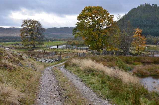
Am Maol Images

Images are sourced within 2km of 57.021093/-4.3637776 or Grid Reference NN5694. Thanks to Geograph Open Source API. All images are credited.

Old Bridge on Wade's Road
Trees on a knoll
Trees on a knoll
Spey Reservoir
Spey Reservoir
Low water at the Spey Dam
Road beside Spey Dam The Spey has been dammed here so that water can be fed into the Glen Spean catchment for electricity generation. The power is used for aluminium smelting at Fort William.
Road beside Spey Dam
The Spey has been dammed here so that water can be fed into the Glen Spean catchment for electricity generation. The power is used for aluminium smelting at Fort William.
Spey Reservoir
Spey Reservoir
Ruin, Shirrabeg Beside the Spey Reservoir.
Ruin, Shirrabeg
Beside the Spey Reservoir.
Garva Bridge to Laggan Road Passing Shirrabeg.
Garva Bridge to Laggan Road
Passing Shirrabeg.
Sluice, Spey Dam The Spey has been dammed and reversed through an artificial channel into the Glen Spean drainage to provide water for the Lochaber aluminium smelter.
Sluice, Spey Dam
The Spey has been dammed and reversed through an artificial channel into the Glen Spean drainage to provide water for the Lochaber aluminium smelter.
Spey Dam aqueduct Channel dug to take water from the Spey dam towards Loch Laggan where it is used to generate electricity for the Lochaber aluminium smelter.
Spey Dam aqueduct
Channel dug to take water from the Spey dam towards Loch Laggan where it is used to generate electricity for the Lochaber aluminium smelter.
Young trees, Glen Shirra Enlarged woodland near the Spey Reservoir.
Young trees, Glen Shirra
Enlarged woodland near the Spey Reservoir.
General Wade's bridge near Glen Shira Having a rest while following the route of the Corrieyairack Pass. 

The hump-back military bridge, built by General Wade and dating from 1731-2 no longer crosses a burn, following the alteration of the course of the burn when the nearby Spey Dam was constructed in 1946. It is Category B listed.
General Wade's bridge near Glen Shira
Having a rest while following the route of the Corrieyairack Pass. The hump-back military bridge, built by General Wade and dating from 1731-2 no longer crosses a burn, following the alteration of the course of the burn when the nearby Spey Dam was constructed in 1946. It is Category B listed.
Spey Reservoir Looking along Spey Reservoir from the road which runs along the loch's southern side.
Spey Reservoir
Looking along Spey Reservoir from the road which runs along the loch's southern side.
The Spey Dam Looking across the side of the dam which holds the water back in the reservoir. The dam's outlet into the River Spey is through the taller section of wall nearer the camera.
The Spey Dam
Looking across the side of the dam which holds the water back in the reservoir. The dam's outlet into the River Spey is through the taller section of wall nearer the camera.
Entrance to Melgarve construction site, Spey Dam Work is in progress to build an electricity substation to allow connection of the Stronelairg wind farm to the Beauly-Denny grid line. For further details, see <span class="nowrap"><a title="https://www.ssen-transmission.co.uk/projects/stronelairg-wind-farm-connection/" rel="nofollow ugc noopener" href="https://www.ssen-transmission.co.uk/projects/stronelairg-wind-farm-connection/">Link</a><img style="margin-left:2px;" alt="External link" title="External link - shift click to open in new window" src="https://s1.geograph.org.uk/img/external.png" width="10" height="10"/></span>.
Entrance to Melgarve construction site, Spey Dam
Work is in progress to build an electricity substation to allow connection of the Stronelairg wind farm to the Beauly-Denny grid line. For further details, see LinkExternal link.
Glen Markie track, Crathie The track up the glen a short way N of the Melgarve construction site entrance shown in <a href="https://www.geograph.org.uk/photo/5938854">NN5893 : Entrance to Melgarve construction site, Spey Dam</a>.
Glen Markie track, Crathie
The track up the glen a short way N of the Melgarve construction site entrance shown in NN5893 : Entrance to Melgarve construction site, Spey Dam.
Track to Glen Markie The track passes conifer plantations on both sides of the southern end of the glen.
Track to Glen Markie
The track passes conifer plantations on both sides of the southern end of the glen.
Track to Glen Markie The well-surfaced track continues about another 3km where it becomes less distinct.
Track to Glen Markie
The well-surfaced track continues about another 3km where it becomes less distinct.
Show me another place!

Am Maol is located at Grid Ref: NN5694 (Lat: 57.021093, Lng: -4.3637776)

Unitary Authority: Highland

Police Authority: Highlands and Islands

What 3 Words

///absorbing.jazz.clocking. Near Newtonmore, Highland

Nearby Locations

Am Maol

Related Wikis

Dùn dà Làmh

Dùn dà Làmh is a Pictish now ruined hill fort near Laggan in the Scottish Highlands. It became a scheduled monument in 1986, with an extension to the protected...

Laggan, Badenoch

Laggan (Gaelic: Lagan ) is a village in Badenoch, in the Highland region of Scotland. It is beside the River Spey, about 10 km west of Newtonmore. The...

Kinloch Laggan

Kinloch Laggan (Scottish Gaelic: Ceann Loch Lagain) is a hamlet located at the head of Loch Laggan in Newtonmore, Inverness-shire, Scottish Highlands...

Falls of Pattack

Falls of Pattack is a waterfall in the Scottish Highlands' Cairngorm National Park. The falls are on the River Pattack, about 2 km south of the A86 road...

East Highland Way

The East Highland Way (Scottish Gaelic: Slighe Gaidhealtachd an Ear) is a long-distance walking route in Scotland that connects Fort William (56.8178°N...

Catlodge

Catlodge (Scottish Gaelic: Caitleag) is a hamlet, in the district of Newtonmore in Inverness-shire, Scottish Highlands and is in the Scottish council...
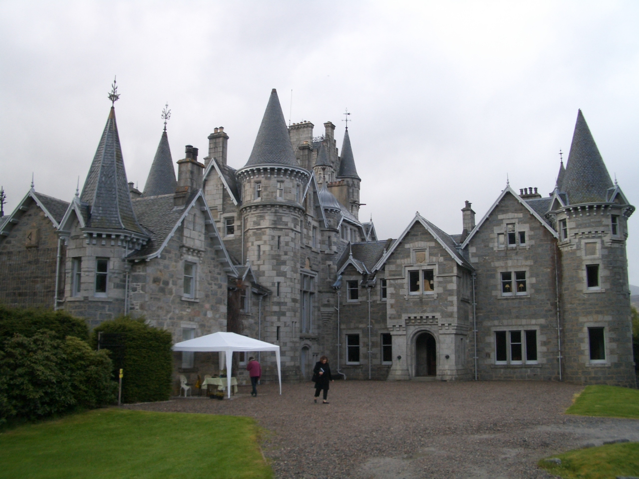
Ardverikie House

Ardverikie House is a 19th-century Scottish baronial house in Kinloch Laggan, Newtonmore, Inverness-shire, Scottish Highlands. The house was made famous...

Have you been to Am Maol?

Leave your review of Am Maol below (or comments, questions and feedback).