Shaugh Moor

Hill, Mountain in Devon South Hams

England

Shaugh Moor

Old Bridge Marker in Shaugh Prior near Cadover Bridge County Bridge Marker on the north side of the road from Cadover Bridge, River Plym, to Blackaton Cross, 30 metres southeast of the junction below the bridge. Shaugh Prior parish. Inscribed C to mark the extent of roadway adjoining the bridge that the County was obliged to maintain.

Milestone Society National ID: DV_IBSP01Abr
Old Bridge Marker in Shaugh Prior near Cadover Bridge Credit: T Jenkinson

The requested URL returned error: 429 Too Many Requests

If you have any feedback on the listing, please let us know in the comments section below.
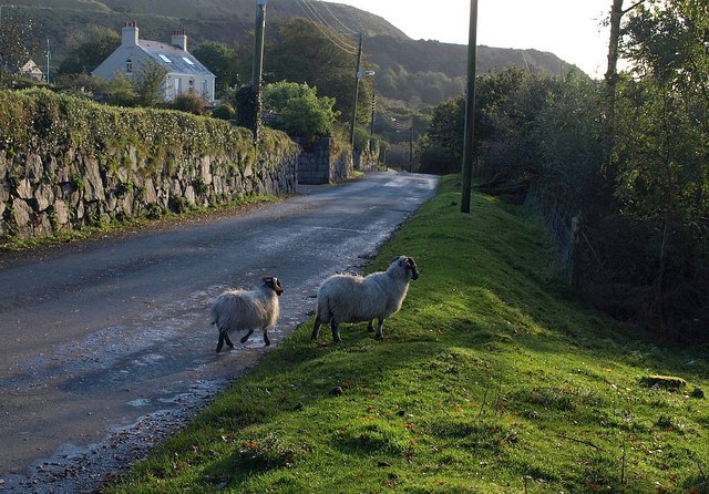
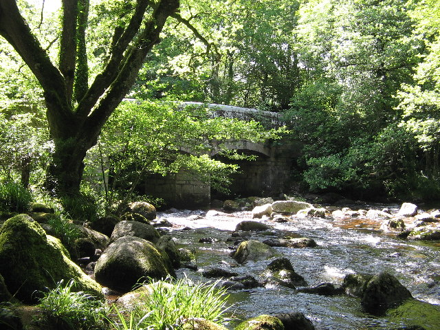
Shaugh Moor Images

Images are sourced within 2km of 50.451001/-4.0312118 or Grid Reference SX5563. Thanks to Geograph Open Source API. All images are credited.

Old Bridge Marker in Shaugh Prior near Cadover Bridge County Bridge Marker on the north side of the road from Cadover Bridge, River Plym, to Blackaton Cross, 30 metres southeast of the junction below the bridge. Shaugh Prior parish. Inscribed C to mark the extent of roadway adjoining the bridge that the County was obliged to maintain.

Milestone Society National ID: DV_IBSP01Abr
Old Bridge Marker in Shaugh Prior near Cadover Bridge
County Bridge Marker on the north side of the road from Cadover Bridge, River Plym, to Blackaton Cross, 30 metres southeast of the junction below the bridge. Shaugh Prior parish. Inscribed C to mark the extent of roadway adjoining the bridge that the County was obliged to maintain. Milestone Society National ID: DV_IBSP01Abr
Moorland Hotel, Wotter A lovely place to stay.
Moorland Hotel, Wotter
A lovely place to stay.
Cadover Bridge The line of upright stones is somewhat reminiscent of the prehistoric stones row found on Dartmoor, but these ones are to stop vehicles straying.
Cadover Bridge
The line of upright stones is somewhat reminiscent of the prehistoric stones row found on Dartmoor, but these ones are to stop vehicles straying.
Alluvial Tin Streamwork at Brisworthy Burrows An extensive and well preserved alluvial tin streamwork.
Alluvial Tin Streamwork at Brisworthy Burrows
An extensive and well preserved alluvial tin streamwork.
Cadover Bridge
Cadover Bridge
Minor road in the valley of the Plym at Cadover Bridge
Road on the edge of Shaugh Moor Looking south by the junction for Brag Lane on the right
Road on the edge of Shaugh Moor
Looking south by the junction for Brag Lane on the right
Road entering Wotter from the moor on the west The pole on the left of the road is there to brace that opposite
Road entering Wotter from the moor on the west
The pole on the left of the road is there to brace that opposite
Rosemary Close in Wotter A small residential estate
Rosemary Close in Wotter
A small residential estate
Side road to Wotter on the east The village is just off the main road across the moorland.  This side road leads into the village on the eastern side
Side road to Wotter on the east
The village is just off the main road across the moorland. This side road leads into the village on the eastern side
Ordnance Survey Cut Mark This OS cut mark can be found on the west face of St Edward's Church. It marks a point 183.154m above mean sea level.
Ordnance Survey Cut Mark
This OS cut mark can be found on the west face of St Edward's Church. It marks a point 183.154m above mean sea level.
Pigs making best use of rough pasture, near Cadover Bridge, Dartmoor
Bend in the River Plym, plus confluence with small stream, Cadover Bridge, Dartmoor I cannot really call this kink in the River Plym a meander!
Bend in the River Plym, plus confluence with small stream, Cadover Bridge, Dartmoor
I cannot really call this kink in the River Plym a meander!
Old Wayside Cross on Shaugh Moor Blackaton Cross (Roman's Cross), old head in a new cross. Starkey No.34 by the UC road, in parish of Shaugh Prior (South Hams District), end of the service road that runs along the boundary of Lee Moor China Clay workings up to Emmets Post, on the moorland verge.

Grade II listed. List Entry Number: 1107433
<span class="nowrap"><a title="https://historicengland.org.uk/listing/the-list/list-entry/1107433" rel="nofollow ugc noopener" href="https://historicengland.org.uk/listing/the-list/list-entry/1107433">Link</a><img style="margin-left:2px;" alt="External link" title="External link - shift click to open in new window" src="https://s1.geograph.org.uk/img/external.png" width="10" height="10"/></span>
Scheduled Monument. List Entry Number: 1008930
<span class="nowrap"><a title="https://historicengland.org.uk/listing/the-list/list-entry/1008930" rel="nofollow ugc noopener" href="https://historicengland.org.uk/listing/the-list/list-entry/1008930">Link</a><img style="margin-left:2px;" alt="External link" title="External link - shift click to open in new window" src="https://s1.geograph.org.uk/img/external.png" width="10" height="10"/></span>

Surveyed 

Milestone Society National ID: DVSH_SPR02
Old Wayside Cross on Shaugh Moor
Blackaton Cross (Roman's Cross), old head in a new cross. Starkey No.34 by the UC road, in parish of Shaugh Prior (South Hams District), end of the service road that runs along the boundary of Lee Moor China Clay workings up to Emmets Post, on the moorland verge. Grade II listed. List Entry Number: 1107433 LinkExternal link Scheduled Monument. List Entry Number: 1008930 LinkExternal link Surveyed Milestone Society National ID: DVSH_SPR02
Old Boundary Marker by Blacka Brook, Shaugh Moor, Shaugh Prior Parish Estate Boundary Marker in parish of Shaugh Prior (South Hams District), Shaugh Moor, beside Blacka Brook.

Surveyed

Milestone Society National ID: DV_SHAUPR04em
Old Boundary Marker by Blacka Brook, Shaugh Moor, Shaugh Prior Parish
Estate Boundary Marker in parish of Shaugh Prior (South Hams District), Shaugh Moor, beside Blacka Brook. Surveyed Milestone Society National ID: DV_SHAUPR04em
Old Wayside Cross by Brag Lane, Shaugh Prior, South Hams Shaugh Prior Cross, old head, shaft and base, Starkey No.32 by the UC road, in parish of Shaugh Prior (South Hams District), Crossgates, junction with Brag Lane, beside drive to the Vicarage, high in a hedge bank.

Grade II Listed. List Entry Number: 1325423
<span class="nowrap"><a title="https://historicengland.org.uk/listing/the-list/list-entry/1325423" rel="nofollow ugc noopener" href="https://historicengland.org.uk/listing/the-list/list-entry/1325423">Link</a><img style="margin-left:2px;" alt="External link" title="External link - shift click to open in new window" src="https://s1.geograph.org.uk/img/external.png" width="10" height="10"/></span>
Scheduled Monument. List Entry Number: 1009187
<span class="nowrap"><a title="https://historicengland.org.uk/listing/the-list/list-entry/1009187" rel="nofollow ugc noopener" href="https://historicengland.org.uk/listing/the-list/list-entry/1009187">Link</a><img style="margin-left:2px;" alt="External link" title="External link - shift click to open in new window" src="https://s1.geograph.org.uk/img/external.png" width="10" height="10"/></span>
surveyed

Milestone Society National ID: DVSH_SPR04
Old Wayside Cross by Brag Lane, Shaugh Prior, South Hams
Shaugh Prior Cross, old head, shaft and base, Starkey No.32 by the UC road, in parish of Shaugh Prior (South Hams District), Crossgates, junction with Brag Lane, beside drive to the Vicarage, high in a hedge bank. Grade II Listed. List Entry Number: 1325423 LinkExternal link Scheduled Monument. List Entry Number: 1009187 LinkExternal link surveyed Milestone Society National ID: DVSH_SPR04
Old Boundary Marker by Old Cornwood Road, Shaugh Moor Boundary Marker by the UC road, in parish of Cornwood (South Hams District), Old Cornwood Road, quarter mile North of Emmets Post Car Park, on grass/muddy verge.

Inscription reads:-
: SM / 1835 : : LM / 1835 :

Grade II Listed. List Entry Number: 1309452
<span class="nowrap"><a title="https://historicengland.org.uk/listing/the-list/list-entry/1309452" rel="nofollow ugc noopener" href="https://historicengland.org.uk/listing/the-list/list-entry/1309452">Link</a><img style="margin-left:2px;" alt="External link" title="External link - shift click to open in new window" src="https://s1.geograph.org.uk/img/external.png" width="10" height="10"/></span>

Surveyed

Milestone Society National ID: DV_CBEP01bm
Old Boundary Marker by Old Cornwood Road, Shaugh Moor
Boundary Marker by the UC road, in parish of Cornwood (South Hams District), Old Cornwood Road, quarter mile North of Emmets Post Car Park, on grass/muddy verge. Inscription reads:- : SM / 1835 : : LM / 1835 : Grade II Listed. List Entry Number: 1309452 LinkExternal link Surveyed Milestone Society National ID: DV_CBEP01bm
Old Boundary Marker on Shaugh Moor, Shaugh Prior Estate Boundary Marker in parish of Shaugh Prior (South Hams District), Shaugh Moor.

Inscription reads:- : SM / 1835 :

Surveyed

Milestone Society National ID: DV_SHAUPR03em
Old Boundary Marker on Shaugh Moor, Shaugh Prior
Estate Boundary Marker in parish of Shaugh Prior (South Hams District), Shaugh Moor. Inscription reads:- : SM / 1835 : Surveyed Milestone Society National ID: DV_SHAUPR03em
Show me another place!

Shaugh Moor is located at Grid Ref: SX5563 (Lat: 50.451001, Lng: -4.0312118)

Administrative County: Devon

District: South Hams

Police Authority: Devon and Cornwall

What 3 Words

///swordfish.dancer.excavate. Near Yelverton, Devon

Nearby Locations

Shaugh Moor

Related Wikis

Dewerstone

Dewerstone is the site of an Iron Age Hill fort on a rocky promontory overlooking the River Plym on the South West edge of Dartmoor to the North of Plympton...

Wotter

Wotter is a village near Shaugh Prior on the south western edge of Dartmoor, in the English county of Devon. The village was founded in 1906: previously...

Shaugh Prior

Shaugh Prior is a village and civil parish on the south-western side of Dartmoor in the county of Devon, England. It is situated about 8 miles north-east...

Brisworthy stone circle

Brisworthy stone circle (grid reference SX564654) is a stone circle on Dartmoor, Devon. It is located three miles east of the A386, northeast of the village...

Nearby Amenities

Located within 500m of 50.451001,-4.0312118
Man Made: survey_point
Lat/Long: 50.450975/-4.0312549
The data included in this document is from www.openstreetmap.org. The data is made available under ODbL.

Have you been to Shaugh Moor?

Leave your review of Shaugh Moor below (or comments, questions and feedback).