Balsall Street

Settlement in Warwickshire

England

Balsall Street

Balsall Common-The Saracen's Head Inn On the western fringes of the village.
Balsall Common-The Saracen's Head Inn Credit: Ian Rob

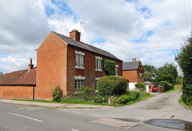
Balsall Street is a small village located in the county of Warwickshire, England. Situated near the town of Coventry, it falls within the Metropolitan Borough of Solihull. The village is nestled amidst picturesque countryside, with rolling hills and fields surrounding the area.

Balsall Street is known for its quaint and peaceful atmosphere, making it an ideal location for those seeking a tranquil village life. The village boasts charming cottages and houses, many of which are built with traditional Warwickshire architecture. The streets are lined with beautiful trees, adding to the overall scenic beauty of the area.

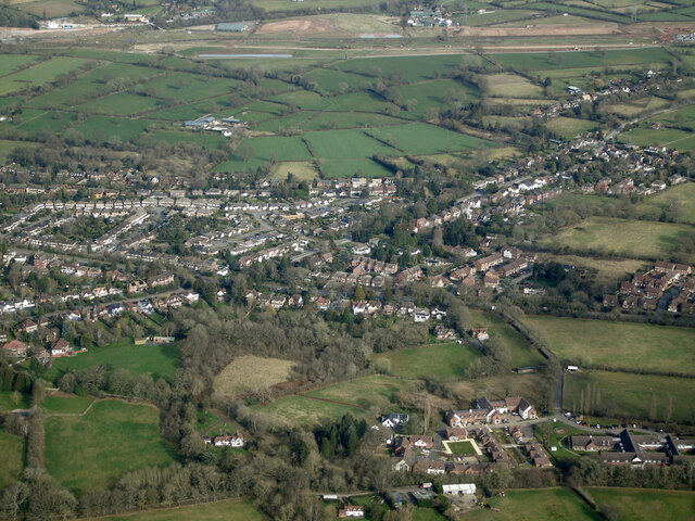
The village has a close-knit community, with a range of amenities available to its residents. These include a local pub, a village hall, a primary school, and a post office. The nearby town of Coventry provides additional facilities such as supermarkets, shopping centers, and healthcare services.

For nature enthusiasts, Balsall Street offers numerous opportunities for outdoor activities. The surrounding countryside provides ample space for walking, cycling, and exploring the nearby nature reserves. The village is also conveniently located near the Heart of England Way, a long-distance footpath that provides stunning views of the Warwickshire countryside.

Overall, Balsall Street is a charming village that offers a peaceful and idyllic retreat from the hustle and bustle of nearby urban areas. Its beautiful surroundings, strong sense of community, and range of amenities make it an attractive place to live for those seeking a rural lifestyle in Warwickshire.

If you have any feedback on the listing, please let us know in the comments section below.

Balsall Street Images

Images are sourced within 2km of 52.38873/-1.668617 or Grid Reference SP2276. Thanks to Geograph Open Source API. All images are credited.

Balsall Common-The Saracen's Head Inn On the western fringes of the village.
Balsall Common-The Saracen's Head Inn
On the western fringes of the village.
Balsall Common-Hobbe Cottage On Balsall Street.
Balsall Common-Hobbe Cottage
On Balsall Street.
Balsall Common-Ivy House Farm On Needlers End Lane.
Balsall Common-Ivy House Farm
On Needlers End Lane.
Balsall Common-The White Horse Public House on Kenilworth Road.
Balsall Common-The White Horse
Public House on Kenilworth Road.
Balsall Street View from the Lay-by.
Balsall Street
View from the Lay-by.
Blythe House Farm from the air Seen on approach to Birmingham Airport from a flight from Prague.
Blythe House Farm from the air
Seen on approach to Birmingham Airport from a flight from Prague.
Barston Lane sewage works from the air Seen on approach to Birmingham from a flight from Prague.
Barston Lane sewage works from the air
Seen on approach to Birmingham from a flight from Prague.
HS2 construction site near Balsall Common from the air Balsall Common is in the foreground, with the HS2 works in the distance. Viewed from a Birmingham bound flight from Prague.
HS2 construction site near Balsall Common from the air
Balsall Common is in the foreground, with the HS2 works in the distance. Viewed from a Birmingham bound flight from Prague.
HS2 construction near Balsall Common from the air Looking along Station Road, the line of the HS2 works can be seen in the distance. Viewed from a Birmingham bound flight from Prague.
HS2 construction near Balsall Common from the air
Looking along Station Road, the line of the HS2 works can be seen in the distance. Viewed from a Birmingham bound flight from Prague.
The Elms from the air Just off the B4101 Balsall Street, west of Balsall Common. Viewed from a Birmingham bound flight from Prague.
The Elms from the air
Just off the B4101 Balsall Street, west of Balsall Common. Viewed from a Birmingham bound flight from Prague.
Balsall Common from the air The B4101 Balsall Street in the west side of Balsall Common is prominent. Viewed from a Birmingham bound flight from Prague.
Balsall Common from the air
The B4101 Balsall Street in the west side of Balsall Common is prominent. Viewed from a Birmingham bound flight from Prague.
Balsall Common from the air The B4101 Balsall Street East, on the south side of Balsall Common is prominent, as are the playing fields at Heart of England School and Berkswell Cricket Club. Viewed from a Birmingham bound flight from Prague.
Balsall Common from the air
The B4101 Balsall Street East, on the south side of Balsall Common is prominent, as are the playing fields at Heart of England School and Berkswell Cricket Club. Viewed from a Birmingham bound flight from Prague.
Balsall Common from the air Heart of England School and Balsall Common Primary School are prominent, as is Berkswell Cricket Club and the A452 road. Viewed from a Birmingham bound flight from Prague.
Balsall Common from the air
Heart of England School and Balsall Common Primary School are prominent, as is Berkswell Cricket Club and the A452 road. Viewed from a Birmingham bound flight from Prague.
HS2 works, Solihull district, February 2022 The eastbound A452 Kenilworth Road approaches two new junctions. The first is with a private drive soon followed by a new roundabout at the junction with Park Lane, which leads to Berkswell village. HS2 will run parallel to A452 here.
HS2 works, Solihull district, February 2022
The eastbound A452 Kenilworth Road approaches two new junctions. The first is with a private drive soon followed by a new roundabout at the junction with Park Lane, which leads to Berkswell village. HS2 will run parallel to A452 here.
HS2 works, Solihull district, February 2022 This is the remodelled junction of Park Lane with A452 seen from the latter. HS2 will pass in a cutting beyond these works. The Park Lane route to Berkswell village will be stopped up to serve just one property <a href="https://www.geograph.org.uk/photo/1187139">SP2378 : West along Park Lane</a>. Berkswell will continue to be reached from Balsall Common via Lavender Hall Lane.
HS2 works, Solihull district, February 2022
This is the remodelled junction of Park Lane with A452 seen from the latter. HS2 will pass in a cutting beyond these works. The Park Lane route to Berkswell village will be stopped up to serve just one property SP2378 : West along Park Lane. Berkswell will continue to be reached from Balsall Common via Lavender Hall Lane.
Methodist church, Balsall Common This otherwise very plain suburban church has a striking spire.
Methodist church, Balsall Common
This otherwise very plain suburban church has a striking spire.
Field path, Balsall Common There is a good network of public footpaths in the fields around this suburban settlement.
Field path, Balsall Common
There is a good network of public footpaths in the fields around this suburban settlement.
A pair of alder trees, Balsall Common I was off-piste here, as the public footpath was poorly marked and difficult to follow.
A pair of alder trees, Balsall Common
I was off-piste here, as the public footpath was poorly marked and difficult to follow.
Show me another place!

Balsall Street is located at Grid Ref: SP2276 (Lat: 52.38873, Lng: -1.668617)

Unitary Authority: Solihull

Police Authority: West Midlands

What 3 Words

///prefer.suffer.equivocal. Near Balsall Common, West Midlands

Nearby Locations

Balsall Street

Related Wikis

Heart of England Way

The Heart of England Way is a long-distance walk of around 160 km (100 mi) through the Midlands of England. The walk starts from Milford Common on Cannock...

Balsall Common

Balsall Common is a large village in the Metropolitan Borough of Solihull, West Midlands, England. It is situated 5 miles (7.5 km) northwest of Kenilworth...

A452 road

The A452 is a road in England, which runs from Royal Leamington Spa, Warwickshire to Brownhills in the West Midlands. It is the major link to the M6 motorway...

Heart of England School

Heart of England School is a secondary school and sixth form with academy status located in Balsall Common in the West Midlands. The Headteacher, who started...

Meriden Gap

The Meriden Gap is a mostly rural area in the West Midlands between Solihull and Coventry. It is a part of the wider West Midlands Green Belt, separating...

Berkswell railway station

Berkswell railway station ( BURK-swəl), in the West Midlands of England, takes its name from the nearby village of Berkswell although it is located on...

Balsall Preceptory

Balsall Preceptory in Warwickshire was a manor that was given to the Knights Templars in recognition of their service in the Crusades. The donor, according...

Temple Balsall

Temple Balsall (grid reference SP207760) is a small hamlet within the Metropolitan Borough of Solihull in the English West Midlands, situated between the...

Nearby Amenities

Located within 500m of 52.38873,-1.668617
Booth: K6
Removed Amenity: telephone
Lat/Long: 52.3882157/-1.6657461
Post Box
Collection Times: Mo-Fr 09:00; Sa 07:00
Operator: Royal Mail
Post Box Type: lamp
Ref: CV7 139D
Royal Cypher: EIIR
Royal Cypher Wikidata: Q33102113
Source: survey
Lat/Long: 52.388659/-1.6666668
Bus Stop
Balsall Street / Needlers End Lane
Bus: yes
Naptan AtcoCode: 43000109201
Naptan Bearing: W
Naptan BusStopType: MKD
Naptan CommonName: Needlers End Lane
Naptan Indicator: opp
Naptan NaptanCode: nwmgatam
Naptan PlusbusZoneRef: BHAMNWS
Naptan Status: ACT
Naptan StopType: BCT
Naptan Street: BALSALL STREET
Naptan Towards: Solihull
Naptan Verified: no
Public Transport: platform
Route Ref: 87;233
Source: WMCA
Lat/Long: 52.3885848/-1.6668407
Bus Stop
Balsall Street / Needlers End Lane
Bus: yes
Naptan AtcoCode: 43000109202
Naptan Bearing: E
Naptan BusStopType: CUS
Naptan CommonName: Needlers End Lane
Naptan Indicator: adj
Naptan NaptanCode: nwmgatap
Naptan PlusbusZoneRef: BHAMNWS
Naptan Status: ACT
Naptan StopType: BCT
Naptan Street: BALSALL STREET
Naptan Towards: Balsall Common
Naptan Verified: no
Public Transport: platform
Route Ref: 87;233
Source: WMCA
Lat/Long: 52.3884005/-1.6659936
Bus Stop
Balsall Street / Old Saracens Head
Bus: yes
Naptan AtcoCode: 43000109301
Naptan Bearing: NW
Naptan BusStopType: MKD
Naptan CommonName: Old Saracens Head
Naptan Indicator: adj
Naptan NaptanCode: nwmgatat
Naptan PlusbusZoneRef: BHAMNWS
Naptan Status: ACT
Naptan StopType: BCT
Naptan Street: BALSALL STREET
Naptan Towards: Solihull
Naptan Verified: no
Public Transport: platform
Route Ref: 87;233
Source: WMCA
Lat/Long: 52.3910093/-1.6722302
Bus Stop
Balsall Street / Old Saracens Head
Bus: yes
Naptan AtcoCode: 43000109302
Naptan Bearing: SE
Naptan BusStopType: CUS
Naptan CommonName: Old Saracens Head
Naptan Indicator: opp
Naptan NaptanCode: nwmgataw
Naptan PlusbusZoneRef: BHAMNWS
Naptan Status: ACT
Naptan StopType: BCT
Naptan Street: BALSALL STREET
Naptan Towards: Balsall Common
Naptan Verified: no
Public Transport: platform
Route Ref: 87;233
Source: WMCA
Lat/Long: 52.3910818/-1.6721842
Barrier: stile
Foot: yes
Material: wood
Stile: stepover
Lat/Long: 52.391203/-1.6634172
Turning Circle
Source: bing
Lat/Long: 52.3895908/-1.6637248
Turning Circle
Lat/Long: 52.3883734/-1.6624619
Turning Circle
Lat/Long: 52.3885725/-1.6637213
Power Historic: tower
Source: OS 1:25k
Lat/Long: 52.3918345/-1.6693397
Power Historic: tower
Source: OS 1:25k
Lat/Long: 52.3869415/-1.6691146
Barrier: stile
Foot: yes
Lat/Long: 52.3923329/-1.6690499
Barrier: stile
Source: survey
Lat/Long: 52.3895816/-1.6756009
Barrier: kissing_gate
Source: survey
Lat/Long: 52.39111/-1.6735845
Barrier: stile
Foot: yes
Lat/Long: 52.3911604/-1.672105
Barrier: kissing_gate
Lat/Long: 52.3919961/-1.6670191
Barrier: stile
Lat/Long: 52.3898224/-1.6706781
Bus Stop
Balsall Street / Shenstone Drive
Bus: yes
Naptan AtcoCode: 43001106901
Naptan Bearing: SE
Naptan BusStopType: MKD
Naptan CommonName: Shenstone Drive
Naptan Indicator: adj
Naptan NaptanCode: nwmwgdpg
Naptan Status: ACT
Naptan StopType: BCT
Naptan Street: BALSALL STREET
Naptan Towards: Balsall Common
Public Transport: platform
Route Ref: 87;233
Source: WMCA
Lat/Long: 52.3873004/-1.6625113
Generator Method: photovoltaic
Generator Output Electricity: yes
Generator Source: solar
Generator Type: solar_photovoltaic_panel
Location: roof
Power: generator
Lat/Long: 52.3879315/-1.6636401
Generator Method: photovoltaic
Generator Output Electricity: yes
Generator Source: solar
Generator Type: solar_photovoltaic_panel
Location: roof
Power: generator
Lat/Long: 52.3882548/-1.6632995
Generator Method: photovoltaic
Generator Output Electricity: yes
Generator Source: solar
Generator Type: solar_photovoltaic_panel
Location: roof
Power: generator
Lat/Long: 52.3885069/-1.6634095
Generator Method: photovoltaic
Generator Output Electricity: yes
Generator Source: solar
Generator Type: solar_photovoltaic_panel
Location: roof
Power: generator
Lat/Long: 52.387947/-1.6635342
Generator Method: photovoltaic
Generator Output Electricity: yes
Generator Source: solar
Generator Type: solar_photovoltaic_panel
Location: roof
Power: generator
Lat/Long: 52.3896781/-1.6629776
Generator Method: photovoltaic
Generator Output Electricity: yes
Generator Source: solar
Generator Type: solar_photovoltaic_panel
Location: roof
Power: generator
Lat/Long: 52.3901013/-1.6637112
Generator Method: photovoltaic
Generator Output Electricity: yes
Generator Source: solar
Generator Type: solar_photovoltaic_panel
Location: roof
Power: generator
Lat/Long: 52.3901299/-1.6638185
Generator Method: photovoltaic
Generator Output Electricity: yes
Generator Source: solar
Generator Type: solar_photovoltaic_panel
Location: roof
Power: generator
Lat/Long: 52.3901839/-1.6639084
Generator Method: photovoltaic
Generator Output Electricity: yes
Generator Source: solar
Generator Type: solar_photovoltaic_panel
Location: roof
Power: generator
Lat/Long: 52.390873/-1.6635583
Power: pole
Source: bing
Lat/Long: 52.3854162/-1.6647398
Power: pole
Source: bing
Lat/Long: 52.3870377/-1.6626745
Power: pole
Source: bing
Lat/Long: 52.3864148/-1.6634886
Power: pole
Source: bing
Lat/Long: 52.3857747/-1.6642946
Power: substation
Source: survey
Lat/Long: 52.3870925/-1.6626746
Power: pole
Ref: 720839
Source: wpd_open_data
Transformer: distribution
Lat/Long: 52.3903419/-1.6708741
Power: pole
Source: bing
Lat/Long: 52.3913813/-1.6695517
Power: pole
Source: bing
Lat/Long: 52.3920246/-1.6687953
Material: wood
Power: pole
Source: bing
Lat/Long: 52.3926531/-1.6684064
Power: substation
Ref: 720751
Source: wpd_open_data
Lat/Long: 52.3907272/-1.6646772
Material: wood
Power: pole
Source: bing
Lat/Long: 52.3917038/-1.6668803
Playground: swing
Lat/Long: 52.3907157/-1.6665683
Playground: seesaw
Lat/Long: 52.3907357/-1.6664224
Playground: slide
Lat/Long: 52.390672/-1.6666003
Playground: structure
Lat/Long: 52.3908116/-1.6663651
Playground: structure
Lat/Long: 52.3907765/-1.6665152
Playground: roundabout
Lat/Long: 52.3906521/-1.6664701
Barrier: kissing_gate
Lat/Long: 52.3929706/-1.667189
Power: pole
Ref: 720336
Source: wpd_opendata
Transformer: distribution
Lat/Long: 52.3863297/-1.6668749
Power: pole
Source: bing
Lat/Long: 52.3860579/-1.6655526
Power: pole
Source: bing
Lat/Long: 52.3858828/-1.6647801
Generator Method: photovoltaic
Generator Output Electricity: yes
Generator Source: solar
Generator Type: solar_photovoltaic_panel
Location: roof
Power: generator
Lat/Long: 52.38994/-1.6634363
Generator Method: photovoltaic
Generator Output Electricity: yes
Generator Source: solar
Generator Type: solar_photovoltaic_panel
Location: roof
Power: generator
Lat/Long: 52.389913/-1.6636026
Generator Method: photovoltaic
Generator Output Electricity: yes
Generator Source: solar
Generator Type: solar_photovoltaic_panel
Location: roof
Power: generator
Lat/Long: 52.3897542/-1.671389
The data included in this document is from www.openstreetmap.org. The data is made available under ODbL.

Have you been to Balsall Street?

Leave your review of Balsall Street below (or comments, questions and feedback).