Cnoc Maovally

Hill, Mountain in Sutherland

Scotland

Cnoc Maovally

The Moine House and Ben Loyal
The Moine House and Ben Loyal Credit: Richard Webb

Cnoc Maovally is a prominent hill located in the county of Sutherland, in the northernmost region of the Scottish Highlands. Standing at an elevation of approximately 470 meters (1,540 feet), it is considered a notable landmark within the area.

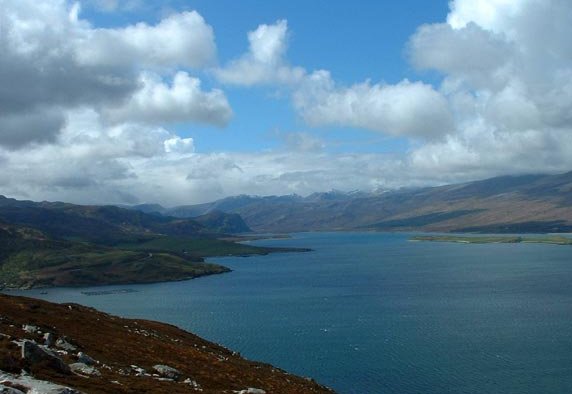
The hill is part of a range known as the Maovally Hills, which are characterized by their rugged terrain and stunning natural beauty. Cnoc Maovally itself is characterized by its distinctive cone-shaped summit, which offers panoramic views of the surrounding countryside.

The hill is a popular destination for hikers and outdoor enthusiasts, who are drawn to its challenging yet rewarding trails. The ascent to the summit can be steep and requires a moderate level of fitness, but the breathtaking vistas make it well worth the effort.

The surrounding area is rich in flora and fauna, with various species of wildflowers, mosses, and lichens dotting the landscape. Wildlife enthusiasts may also spot native species such as red deer, mountain hares, and golden eagles.

Cnoc Maovally is located near the small village of Tongue, which offers amenities such as accommodation, dining options, and visitor information. It is also within close proximity to other notable landmarks such as the Ben Loyal mountain range and the stunning beaches of the north coast.

Overall, Cnoc Maovally is a captivating natural feature in Sutherland, offering visitors a chance to immerse themselves in the untamed beauty of the Scottish Highlands.

If you have any feedback on the listing, please let us know in the comments section below.

Cnoc Maovally Images

Images are sourced within 2km of 58.510975/-4.5639959 or Grid Reference NC5060. Thanks to Geograph Open Source API. All images are credited.

The Moine House and Ben Loyal
Lochan nam Meur Liath A view towards Ben Hope from near the Moine House during a very dry Summer.
Lochan nam Meur Liath
A view towards Ben Hope from near the Moine House during a very dry Summer.
The old alignment of the A838 The previous single track road at the Moine House.
The old alignment of the A838
The previous single track road at the Moine House.
Loch Maovally
Loch Maovally
Lochan nam Meur Liath Near the ruined Moine House is this fine lochan.
Lochan nam Meur Liath
Near the ruined Moine House is this fine lochan.
View over the blanket bog to Ben Hope
Lochan nam Meur Liath Small loch in the blanket bog near Moine House
Lochan nam Meur Liath
Small loch in the blanket bog near Moine House
Moine House Halfway between the Kyle of Tongue and Loch Hope, this stretch of boggy moorland was difficult and dangerous for travellers to traverse until the 1830s when the Duke of Sutherland had a road constructed. The Mòine House was designed along the edge of this road as a shelter for travellers at the halfway point of the roadway. It is now derelict.
Moine House
Halfway between the Kyle of Tongue and Loch Hope, this stretch of boggy moorland was difficult and dangerous for travellers to traverse until the 1830s when the Duke of Sutherland had a road constructed. The Mòine House was designed along the edge of this road as a shelter for travellers at the halfway point of the roadway. It is now derelict.
Blanket bog near Moine House The Flow Country is a large, rolling expanse of peatland and wetland area of Caithness and Sutherland. It is the largest expanse of blanket bog in Europe.
Blanket bog near Moine House
The Flow Country is a large, rolling expanse of peatland and wetland area of Caithness and Sutherland. It is the largest expanse of blanket bog in Europe.
Loch Maovally A shallow loch in the peatlands of the Flow Country. Ben Hope in the clouds beyond.
Loch Maovally
A shallow loch in the peatlands of the Flow Country. Ben Hope in the clouds beyond.
The A838 east of Hope Making its way across the far north of Scotland, through flow Country. A few patches of forestry have been planted here.
The A838 east of Hope
Making its way across the far north of Scotland, through flow Country. A few patches of forestry have been planted here.
Peat bogs of A Moine Ben Tongue in the distance.
Peat bogs of A Moine
Ben Tongue in the distance.
Loch Maovally Shallow moorland loch near the A832. Ben Hope is half hidden in the gloom.
Loch Maovally
Shallow moorland loch near the A832. Ben Hope is half hidden in the gloom.
Moine House Lonely ruin at the side of the old A838, the modern road being some 200m to the north. The house probably dates from the 1830's when the road was constructed for the Duke of Sutherland, and was sited here as this is roughly halfway between Tongue [ferry] and Hope, providing shelter for travellers as well as being the home for a family. The Moine is an extensive area of peatland and bog across much of northern Sutherland and Caithness, and is now recognised as an area of international importance for wildlife and as a carbon sink.
Moine House
Lonely ruin at the side of the old A838, the modern road being some 200m to the north. The house probably dates from the 1830's when the road was constructed for the Duke of Sutherland, and was sited here as this is roughly halfway between Tongue [ferry] and Hope, providing shelter for travellers as well as being the home for a family. The Moine is an extensive area of peatland and bog across much of northern Sutherland and Caithness, and is now recognised as an area of international importance for wildlife and as a carbon sink.
A' Mhoine A rather dreary looking stretch of moorland, generally too soggy to walk on, but of international importance for ground nesting birds, rare plants, and as a unique carbon sink.
A' Mhoine
A rather dreary looking stretch of moorland, generally too soggy to walk on, but of international importance for ground nesting birds, rare plants, and as a unique carbon sink.
Bog pool on The Moine Ben Loyal on the right.
Bog pool on The Moine
Ben Loyal on the right.
Is that a house in the distance? This area is huge peatland with little on it.  There is a house in the distance of this photo, but it is derelict.
Is that a house in the distance?
This area is huge peatland with little on it. There is a house in the distance of this photo, but it is derelict.
Ruined cottage  with Ben Loyal Development opportunity with Ben Loyal roughly south east
Ruined cottage with Ben Loyal
Development opportunity with Ben Loyal roughly south east
Show me another place!

Cnoc Maovally is located at Grid Ref: NC5060 (Lat: 58.510975, Lng: -4.5639959)

Unitary Authority: Highland

Police Authority: Highlands and Islands

What 3 Words

///called.gliding.enchanted. Near Altnaharra, Highland

Nearby Locations

Cnoc Maovally

Related Wikis

Sutherland spaceport

The Sutherland spaceport, also known as Space Hub Sutherland or UKVL Sutherland, is a planned spaceport to be located in Sutherland in Scotland. It would...

A' Mhòine

A' Mhòine (Scottish Gaelic: [ә.ˈvɔːɲә]) is a peninsula in the Highlands, Scotland. The peninsula is bounded to the west by Loch Eriboll, and to the east...

Loch Eriboll

Loch Eriboll (Scottish Gaelic: "Loch Euraboil") is a 16 km (9.9 mi) long sea loch on the north coast of Scotland, which has been used for centuries as...

Portnancon

Portnacon is a small remote crofting township, and former fishing station, on the west shore of Loch Eriboll in Sutherland, Scottish Highlands in the...

Have you been to Cnoc Maovally?

Leave your review of Cnoc Maovally below (or comments, questions and feedback).