Himley

Settlement in Staffordshire South Staffordshire

England

Himley

Play area, Wall Heath
Play area, Wall Heath Credit: Alex McGregor

Himley is a village located in the county of Staffordshire, England. Situated approximately 4 miles southwest of Dudley, it is nestled in the heart of the West Midlands region. The village is renowned for its picturesque surroundings, with rolling hills and tranquil countryside attracting visitors throughout the year.

One of the main attractions in Himley is Himley Hall, a stunning 18th-century mansion set within 180 acres of parkland. The hall, once a residence for the Lords of Dudley, now serves as a popular venue for weddings, conferences, and events. Visitors can explore the beautifully landscaped gardens surrounding the hall, which feature a lake, formal gardens, and stunning views.

The village itself is small and charming, with a cluster of traditional cottages and a local pub providing a cozy atmosphere. The pub, known as The Crooked House, is particularly famous for its eccentric architecture, as the building appears to be tilted due to mining subsidence. It has become a popular spot for tourists and locals alike, offering a unique dining and drinking experience.

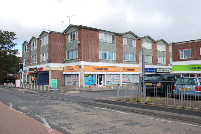
Himley also offers excellent opportunities for outdoor activities, with numerous walking and cycling routes in the nearby countryside. The village is well-connected, with easy access to major road networks, making it a convenient base for exploring the wider Staffordshire area.

Overall, Himley is a delightful village that seamlessly combines history, natural beauty, and a warm community spirit, making it an appealing destination for visitors seeking a peaceful retreat or a taste of traditional English charm.

If you have any feedback on the listing, please let us know in the comments section below.

Himley Images

Images are sourced within 2km of 52.518355/-2.180042 or Grid Reference SO8791. Thanks to Geograph Open Source API. All images are credited.

Play area, Wall Heath
Shopping Precinct, Wall Heath
Cross Street, Wall Heath
St Andrew's Church Wall Heath St Andrew's United Reformed church Wall Heath.
St Andrew's Church Wall Heath
St Andrew's United Reformed church Wall Heath.
The Old Bush (1), Swindon Road, Hinksford Judging by the large number of cars in the car park, this is quite a popular pub. It was built in the mid to late 1930's and replaced an older pub of the same name, dating from 1874 or earlier. That pub was adjacent to the nearby Staffs & Worcs Canal, and was then demolished. The new pub was apparently designed with a ship's bridge in mind, based on the luxury liner the Queen Mary, which was launched in September 1934. A second pub was also rather similarly designed. This was the Nautical William, on the Kidderminster to Bridgnorth road at Alveley. This is now a residential home for the elderly.

The Old Bush should not be confused with the pub of the same name, in the village of Swindon, Staffs, which is only a mile or two away.

<a href="https://www.geograph.org.uk/photo/2817472">SO8689 : The Old Bush (2), Swindon Road, Hinksford</a>.
<a href="https://www.geograph.org.uk/photo/2817486">SO8689 : The Old Bush (3) - sign, Swindon Road, Hinksford</a>.
The Old Bush (1), Swindon Road, Hinksford
Judging by the large number of cars in the car park, this is quite a popular pub. It was built in the mid to late 1930's and replaced an older pub of the same name, dating from 1874 or earlier. That pub was adjacent to the nearby Staffs & Worcs Canal, and was then demolished. The new pub was apparently designed with a ship's bridge in mind, based on the luxury liner the Queen Mary, which was launched in September 1934. A second pub was also rather similarly designed. This was the Nautical William, on the Kidderminster to Bridgnorth road at Alveley. This is now a residential home for the elderly. The Old Bush should not be confused with the pub of the same name, in the village of Swindon, Staffs, which is only a mile or two away. SO8689 : The Old Bush (2), Swindon Road, Hinksford. SO8689 : The Old Bush (3) - sign, Swindon Road, Hinksford.
The Old Bush (2), Swindon Road, Hinksford A large 1930's pub, which also does food.

<a href="https://www.geograph.org.uk/photo/2817465">SO8689 : The Old Bush (1), Swindon Road, Hinksford</a>.
<a href="https://www.geograph.org.uk/photo/2817486">SO8689 : The Old Bush (3) - sign, Swindon Road, Hinksford</a>.
The Old Bush (2), Swindon Road, Hinksford
The Old Bush (3) - sign, Swindon Road, Hinksford The sign, on the edge of the car park adjacent to the road, shows two Roman soldiers on horseback. They appear to be outside a building with a bush attached. The Romans, who ruled the areas now known as England and Wales for almost 400 years, built long straight roads. Along these were built tavernae, from which our word tavern is derived. These tavernae supplied food, drink and overnight accommodation. Tavernae were required to display branches of evergreens outside, so as to identify themselves. This symbolised Bacchus, the Greek god of wine. From this was derived probably the earliest pub name the Bush, or more often the Old Bush or the Holly Bush, and similar names. It is believed that the old saying, "a good wine needs no bush", refers to these early names.

<a href="https://www.geograph.org.uk/photo/2817465">SO8689 : The Old Bush (1), Swindon Road, Hinksford</a>.
<a href="https://www.geograph.org.uk/photo/2817472">SO8689 : The Old Bush (2), Swindon Road, Hinksford</a>.
The Old Bush (3) - sign, Swindon Road, Hinksford
The sign, on the edge of the car park adjacent to the road, shows two Roman soldiers on horseback. They appear to be outside a building with a bush attached. The Romans, who ruled the areas now known as England and Wales for almost 400 years, built long straight roads. Along these were built tavernae, from which our word tavern is derived. These tavernae supplied food, drink and overnight accommodation. Tavernae were required to display branches of evergreens outside, so as to identify themselves. This symbolised Bacchus, the Greek god of wine. From this was derived probably the earliest pub name the Bush, or more often the Old Bush or the Holly Bush, and similar names. It is believed that the old saying, "a good wine needs no bush", refers to these early names. SO8689 : The Old Bush (1), Swindon Road, Hinksford. SO8689 : The Old Bush (2), Swindon Road, Hinksford.
Play Area by Dawley Brook
Hicksford Sub Station
Hinksford Water Works The South Staffordshire pumping station next to the Staffordshire and Worcestershire Canal.
Hinksford Water Works
The South Staffordshire pumping station next to the Staffordshire and Worcestershire Canal.
Hinksford Bridge View The view from the bridge down the Staffordshire and Worcestershire Canal.
Hinksford Bridge View
The view from the bridge down the Staffordshire and Worcestershire Canal.
Blaze Park bus turning circle, Wall Heath This large turning circle, on Enville Road in Wall Heath close to the western extremity of Dudley Metropolitan Borough, is seen here occupied by one of National Express West Midlands' small fleet of DAF DB250/Optare Spectras that migrated to Wolverhampton a couple of years ago. It has paused here on its way from its home town to the Merry Hill Centre on the 255; during the day, about half of the journeys on this route operate only between Merry Hill and here, while the 205 from Blackheath via Dudley town centre also terminates here.
Blaze Park bus turning circle, Wall Heath
This large turning circle, on Enville Road in Wall Heath close to the western extremity of Dudley Metropolitan Borough, is seen here occupied by one of National Express West Midlands' small fleet of DAF DB250/Optare Spectras that migrated to Wolverhampton a couple of years ago. It has paused here on its way from its home town to the Merry Hill Centre on the 255; during the day, about half of the journeys on this route operate only between Merry Hill and here, while the 205 from Blackheath via Dudley town centre also terminates here.
Blaze Hill Road, Wall Heath
Church of the Ascension, Wall Heath Website <span class="nowrap"><a title="http://www.cofasc.freeola.com/" rel="nofollow ugc noopener" href="http://www.cofasc.freeola.com/">Link</a><img style="margin-left:2px;" alt="External link" title="External link - shift click to open in new window" src="https://s1.geograph.org.uk/img/external.png" width="10" height="10"/></span>
Church of the Ascension, Wall Heath
Website LinkExternal link
The Prince Albert Hotel
Saint Andrew's United Reformed Church
The Kingfisher Country Club More Info <span class="nowrap"><a title="http://www.thekingfisherclub.co.uk/" rel="nofollow ugc noopener" href="http://www.thekingfisherclub.co.uk/">Link</a><img style="margin-left:2px;" alt="External link" title="External link - shift click to open in new window" src="https://s1.geograph.org.uk/img/external.png" width="10" height="10"/></span>
The Kingfisher Country Club
More Info LinkExternal link
Dudley Kingswinford Rugby club Website <span class="nowrap"><a title="http://dkrfc.co.uk/directions.html" rel="nofollow ugc noopener" href="http://dkrfc.co.uk/directions.html">Link</a><img style="margin-left:2px;" alt="External link" title="External link - shift click to open in new window" src="https://s1.geograph.org.uk/img/external.png" width="10" height="10"/></span>
Dudley Kingswinford Rugby club
Website LinkExternal link
Show me another place!

Himley is located at Grid Ref: SO8791 (Lat: 52.518355, Lng: -2.180042)

Administrative County: Staffordshire

District: South Staffordshire

Police Authority: Staffordshire

What 3 Words

///pouch.payer.hatch. Near Wombourn, Staffordshire

Nearby Locations

Himley Himley Plantation

Related Wikis

Himley

Himley is a small village and civil parish in Staffordshire, England, 4 miles (6.4 km) west of Dudley and 5 mi (8.0 km) southwest of Wolverhampton. At...

Himley railway station

Himley was a station on the Wombourne Branch Line. Unlike other stops along the route, it was deemed worthy of full station status. It was opened by the...

Holbeche House

Holbeche House (also, in some texts, Holbeach or Holbeache) is a mansion located approximately 1 mile (1.6 km) north of Kingswinford, now in the Metropolitan...

Wombourne

Wombourne is a village and civil parish located in the district of South Staffordshire, in the county of Staffordshire, England. It is 4 miles (6 km) south...

Wall Heath

Wall Heath is a suburban village in the Dudley Metropolitan Borough in the West Midlands of England. It is located on the A449 road, approximately 1.5...

Wom Brook

The Wom Brook is a stream in South Staffordshire, England. It flows through the large village of Wombourne, and has played an important part in its industrial...

Swindon, Staffordshire

Swindon is a village and civil parish located in the West Midlands. The nearest major town is Dudley, approximately five miles eastwards. It stands halfway...
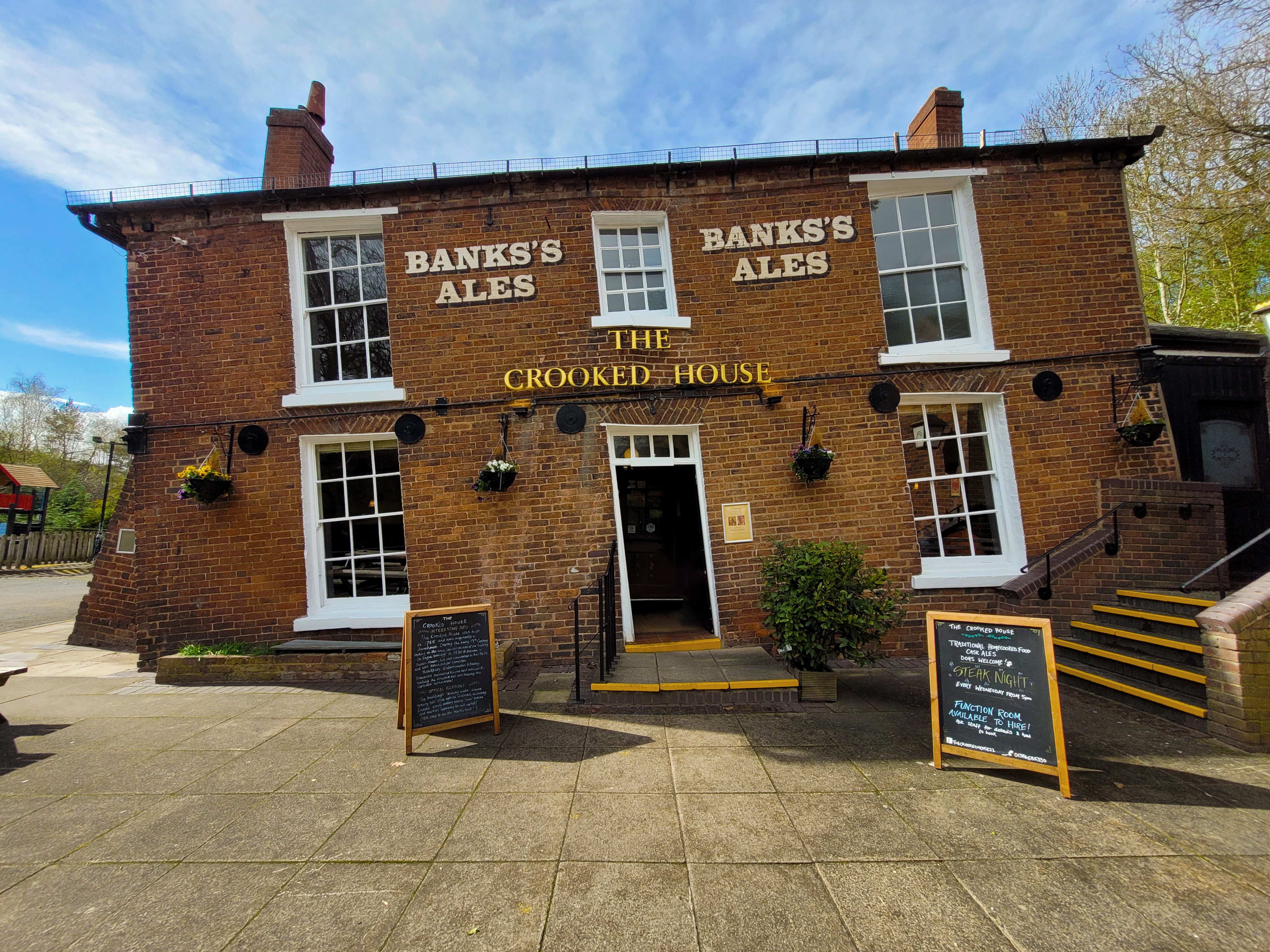
The Crooked House

The Crooked House was a pub in South Staffordshire, England. Its name and distinctive appearance were the result of 19th-century mining subsidence which...

Nearby Amenities

Located within 500m of 52.518355,-2.180042
Traffic Signals
Lat/Long: 52.5199818/-2.1757548
Himley
Created By: Potlatch 0.5d
Is In: Staffordshire
Place: village
Lat/Long: 52.5179793/-2.1771584
Man Made: pipeline_marker
Utility: gas
Lat/Long: 52.5160068/-2.181545
Power: substation
Ref: L315TEED
Lat/Long: 52.5155303/-2.1814484
Power: tower
Lat/Long: 52.5148223/-2.1810753
Power: tower
Lat/Long: 52.5141356/-2.1807381
Bus Stop
Dudley Road
Naptan AtcoCode: 3800C621801
Naptan Bearing: S
Naptan CommonName: Dudley Road
Naptan Indicator: Adj
Naptan Street: Wolverhampton Road
Naptan Verified: no
Public Transport: platform
Source: naptan_import
Lat/Long: 52.5163358/-2.1742905
Bus Stop
Himley House Hotel
Naptan AtcoCode: 3800C624701
Naptan Bearing: N
Naptan CommonName: Himley House Hotel
Naptan Indicator: Opp
Naptan Landmark: Himley House Hotel
Naptan Street: Wolverhampton Rd
Naptan Verified: no
Public Transport: platform
Source: naptan_import
Lat/Long: 52.517899/-2.1750483
Bus Stop
Himley House Hotel
Naptan AtcoCode: 3800C624702
Naptan Bearing: S
Naptan CommonName: The Dudley Arms PH
Naptan Indicator: Opp
Naptan Landmark: The Dudley Arms PH
Naptan Street: Wolverhampton Rd
Naptan Verified: no
Public Transport: platform
Source: naptan_import
Lat/Long: 52.5195795/-2.1754529
Bus Stop
Regal Hotel
Naptan AtcoCode: 3800C624801
Naptan Bearing: SW
Naptan CommonName: Regal Hotel
Naptan Indicator: Opp
Naptan Landmark: Regal Hotel
Naptan Street: School Road
Naptan Verified: no
Public Transport: platform
Source: naptan_import
Lat/Long: 52.5191987/-2.1776326
Bus Stop
Regal Hotel
Naptan AtcoCode: 3800C624802
Naptan Bearing: NE
Naptan CommonName: Himley Mill Nursing Home
Naptan Indicator: Adj
Naptan Landmark: Regal Hotel
Naptan Street: School Road
Naptan Verified: no
Public Transport: platform
Source: naptan_import
Lat/Long: 52.5190539/-2.1782657
Bus Stop
Plantation Lane
Naptan AtcoCode: 3800C624901
Naptan Bearing: NW
Naptan CommonName: Plantation Lane
Naptan Indicator: Opp
Naptan Landmark: Plantation Lane
Naptan Street: Bridgenorth Road
Naptan Verified: no
Public Transport: platform
Source: naptan_import
Lat/Long: 52.5189013/-2.1839538
Bus Stop
Plantation Lane
Naptan AtcoCode: 3800C624902
Naptan Bearing: SE
Naptan CommonName: Plantation Lane
Naptan Indicator: Adj
Naptan Landmark: Plantation Lane
Naptan Street: Bridgenorth Road
Naptan Verified: no
Public Transport: platform
Source: naptan_import
Lat/Long: 52.5191115/-2.1839589
Himley
Historic Railway: station
Railway: site
Source: OS 1:25k
Wikidata: Q5765366
Wikipedia: en:Himley railway station
Lat/Long: 52.5181339/-2.1872493
Pub
Himley House Restaurant
Brand: Chef & Brewer
Brand Wikidata: Q5089491
Website: https://www.chefandbrewer.com/pubs/west-midlands/himley-house
Lat/Long: 52.5188526/-2.1747196
Access: yes
Barrier: entrance
Maxheight Physical: 2.1
Lat/Long: 52.517385/-2.1859488
Tourism: picnic_site
Lat/Long: 52.5179994/-2.1872042
Tourism: picnic_site
Lat/Long: 52.5180454/-2.1874135
Traffic Signals
Source: bing
Lat/Long: 52.5171467/-2.1743261
Traffic Signals
Source: bing
Lat/Long: 52.5168476/-2.1746624
Traffic Signals
Source: bing
Lat/Long: 52.5173014/-2.1747673
Traffic Signals
Source: bing
Lat/Long: 52.5170729/-2.1749631
Generator Method: photovoltaic
Generator Output Electricity: yes
Generator Source: solar
Generator Type: solar_photovoltaic_panel
Location: roof
Power: generator
Lat/Long: 52.5197496/-2.1795872
Generator Method: photovoltaic
Generator Output Electricity: yes
Generator Source: solar
Generator Type: solar_photovoltaic_panel
Location: roof
Power: generator
Lat/Long: 52.519872/-2.17926
Generator Method: photovoltaic
Generator Output Electricity: yes
Generator Source: solar
Generator Type: solar_photovoltaic_panel
Location: roof
Power: generator
Lat/Long: 52.5198899/-2.1794397
Generator Method: photovoltaic
Generator Output Electricity: yes
Generator Source: solar
Generator Type: solar_photovoltaic_panel
Location: roof
Power: generator
Lat/Long: 52.5193416/-2.1787798
Generator Method: photovoltaic
Generator Output Electricity: yes
Generator Source: solar
Generator Type: solar_photovoltaic_panel
Location: roof
Power: generator
Lat/Long: 52.5191963/-2.1787906
Generator Method: photovoltaic
Generator Output Electricity: yes
Generator Source: solar
Generator Type: solar_photovoltaic_panel
Location: roof
Power: generator
Lat/Long: 52.5190282/-2.1792519
Generator Method: photovoltaic
Generator Output Electricity: yes
Generator Source: solar
Generator Type: solar_photovoltaic_panel
Location: roof
Power: generator
Lat/Long: 52.5190755/-2.1794397
Generator Method: photovoltaic
Generator Output Electricity: yes
Generator Source: solar
Generator Type: solar_photovoltaic_panel
Location: roof
Power: generator
Lat/Long: 52.5191522/-2.1795228
Generator Method: photovoltaic
Generator Output Electricity: yes
Generator Source: solar
Generator Type: solar_photovoltaic_panel
Location: roof
Power: generator
Lat/Long: 52.5192567/-2.1793994
Generator Method: photovoltaic
Generator Output Electricity: yes
Generator Source: solar
Generator Type: solar_photovoltaic_panel
Location: roof
Power: generator
Lat/Long: 52.5194003/-2.1789864
The data included in this document is from www.openstreetmap.org. The data is made available under ODbL.

Have you been to Himley?

Leave your review of Himley below (or comments, questions and feedback).