Ben Venue

Hill, Mountain in Perthshire

Scotland

Ben Venue

Not There Yet It's the hottest September day in 115 years and Ben Venue is still some way off. At least there is a bit of a breeze to ease our way up.
Not There Yet Credit: Adam Ward

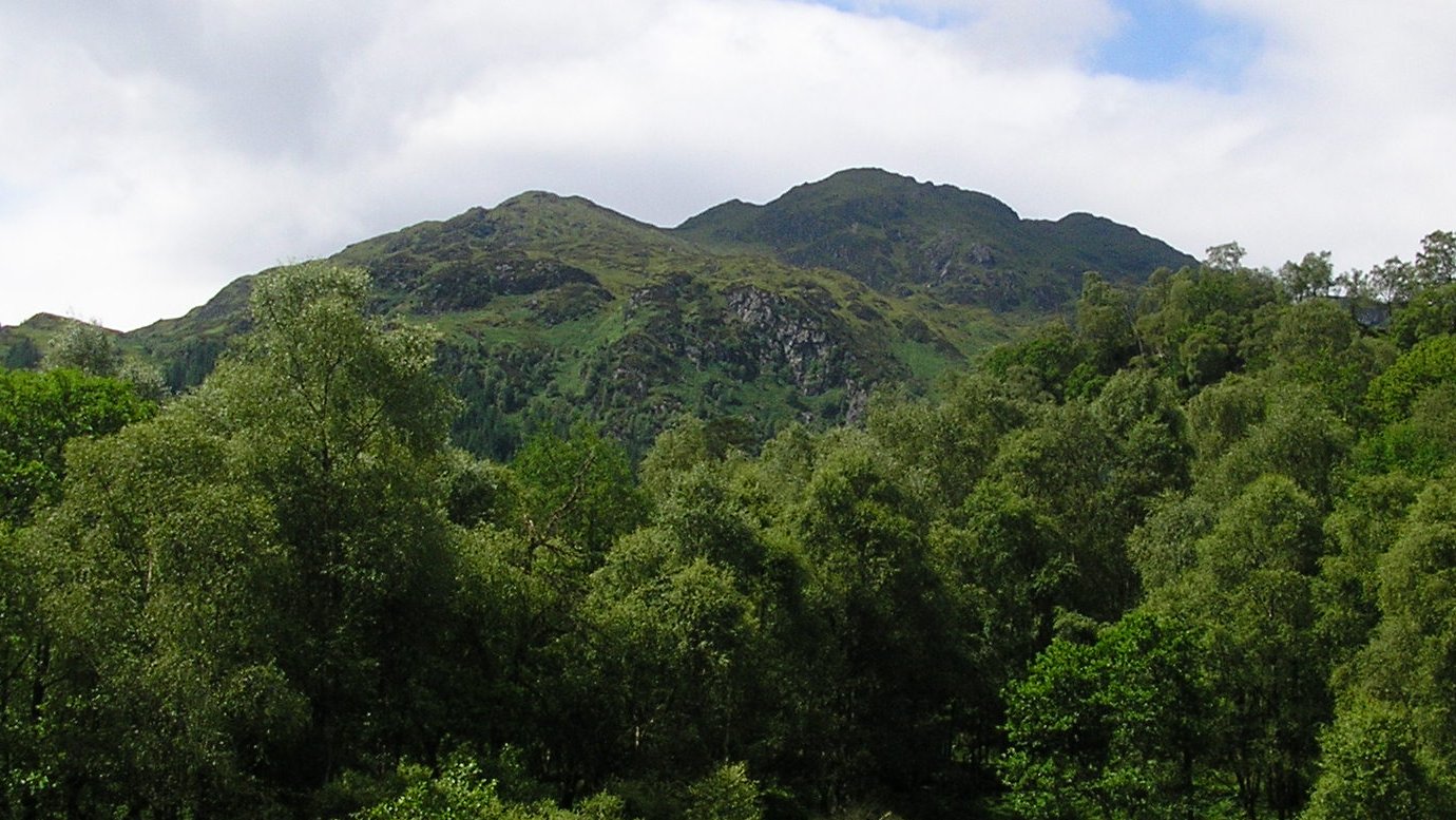
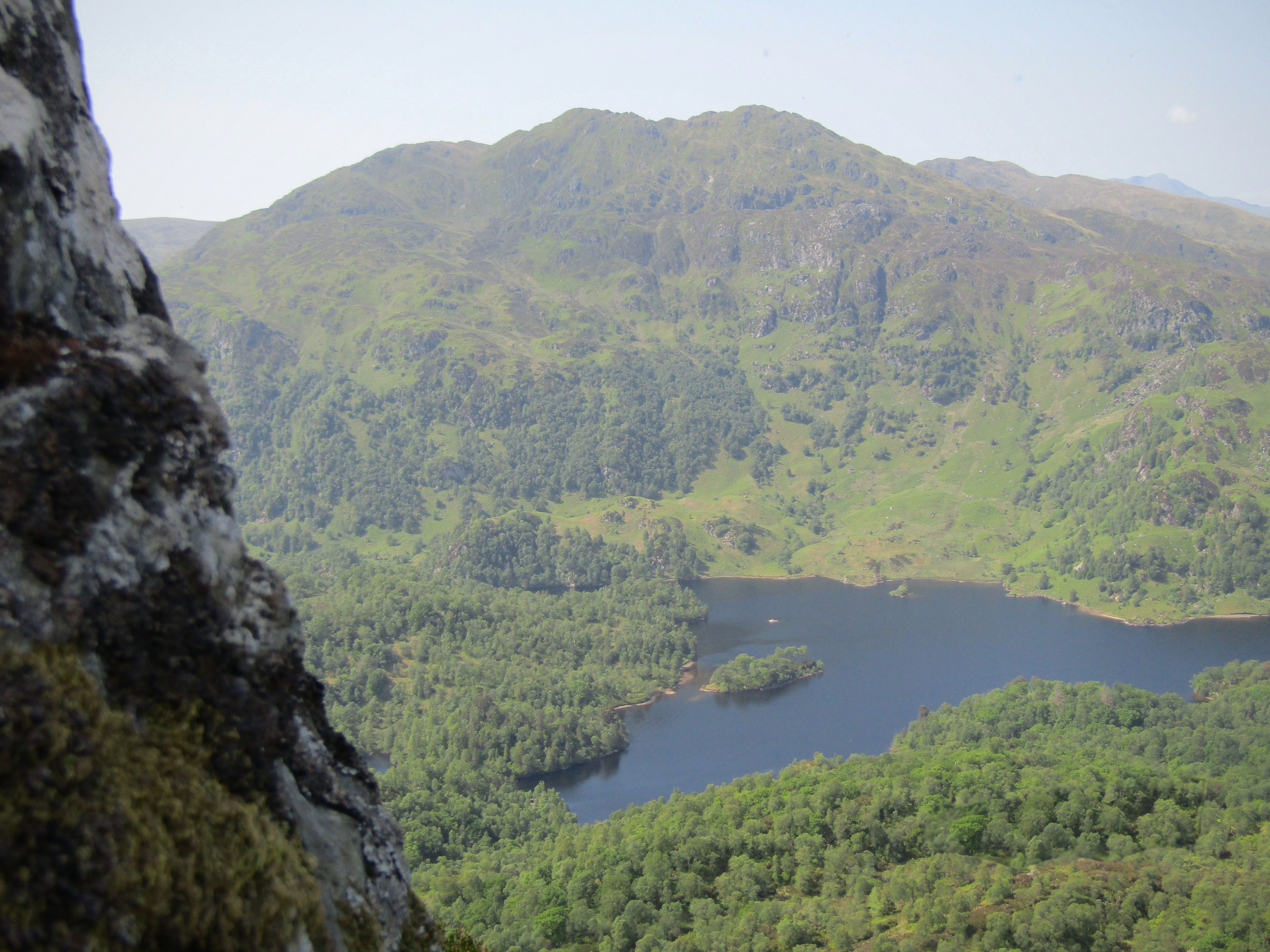
Ben Venue is a prominent hill located in the Trossachs region of Perthshire, Scotland. Standing at a height of 729 meters (2,392 feet), it is a popular destination for hikers and outdoor enthusiasts seeking stunning views of the surrounding countryside.

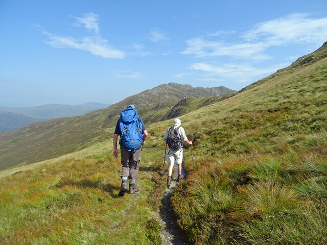
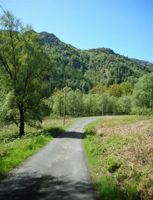
The hill is part of the Loch Lomond and The Trossachs National Park, offering visitors a chance to explore its rugged terrain and diverse wildlife. The ascent to the summit of Ben Venue can be challenging, with steep and rocky paths leading to the top, but the effort is rewarded with panoramic views of Loch Katrine and the surrounding mountains.

Ben Venue is known for its picturesque scenery, with heather-covered slopes and ancient woodlands adding to its natural beauty. The hill is also steeped in history, with tales of Rob Roy MacGregor, the famous Scottish outlaw, being associated with the area.

Overall, Ben Venue is a must-visit destination for those looking to experience the beauty and tranquility of the Scottish Highlands.

If you have any feedback on the listing, please let us know in the comments section below.

Ben Venue Images

Images are sourced within 2km of 56.225059/-4.4620148 or Grid Reference NN4706. Thanks to Geograph Open Source API. All images are credited.

Not There Yet It's the hottest September day in 115 years and Ben Venue is still some way off. At least there is a bit of a breeze to ease our way up.
Not There Yet
It's the hottest September day in 115 years and Ben Venue is still some way off. At least there is a bit of a breeze to ease our way up.
Bealach na h-Imriche Superfluous stile at the Bealach na h-Imriche as there is now no fence.
Looking to Ben Venue on the hottest September day since 1906.
Bealach na h-Imriche
Superfluous stile at the Bealach na h-Imriche as there is now no fence. Looking to Ben Venue on the hottest September day since 1906.
Are we getting too old for this? It has taken us over 30 minutes to cover the last 200 yards or so of track, ducking and diving trees and not helped by a trackside ditch a foot deep in water.  But the worst was now over!
Are we getting too old for this?
It has taken us over 30 minutes to cover the last 200 yards or so of track, ducking and diving trees and not helped by a trackside ditch a foot deep in water. But the worst was now over!
Tributary of the Achray Water in the Achray Forest
Blocked path The sign says the path is blocked but fails to say why.
Blocked path
The sign says the path is blocked but fails to say why.
Ben Venue During yet another non-Winter.
Ben Venue
During yet another non-Winter.
Pass of Achray On the road to the Loch Katrine Dam. Ben Venue is in the distance.

This view replicates the first image for this square <a href="https://www.geograph.org.uk/photo/94439">NN4906 : Pass of Achray</a> taken in 2002 and submitted in 2005.
Pass of Achray
On the road to the Loch Katrine Dam. Ben Venue is in the distance. This view replicates the first image for this square NN4906 : Pass of Achray taken in 2002 and submitted in 2005.
Road to the dam Heading for the Loch Katrine Dam, with Ben Venue in the distance.
Road to the dam
Heading for the Loch Katrine Dam, with Ben Venue in the distance.
Craigleven House A private residence. It was probably connected with the nearby Loch Katrine Dam and related water works.
Craigleven House
A private residence. It was probably connected with the nearby Loch Katrine Dam and related water works.
Buildings at the dam Storage sheds beside the Loch Katrine Dam. The shed on the left is actually a boat shed, and leads directly into the water of Loch Katrine. The sign to the right of the door of the central building says:

TEST POINT
Cable Avoidance Tool
Buildings at the dam
Storage sheds beside the Loch Katrine Dam. The shed on the left is actually a boat shed, and leads directly into the water of Loch Katrine. The sign to the right of the door of the central building says: TEST POINT Cable Avoidance Tool
Loch Katrine Dam Also known as the Achray Dam. The original dam was constructed around 1857. It was rebuilt in 1902 when the water level of Loch Katrine was raised; and again in 1919, when it was raised again. It controls the flow of water from the loch to Loch Achray (hence the name, Achray Dam). It is Category C listed <span class="nowrap"><a title="https://portal.historicenvironment.scot/designation/LB51285" rel="nofollow ugc noopener" href="https://portal.historicenvironment.scot/designation/LB51285">Link</a><img style="margin-left:2px;" alt="External link" title="External link - shift click to open in new window" src="https://s1.geograph.org.uk/img/external.png" width="10" height="10"/></span>.

This view replicates the first image for this square <a href="https://www.geograph.org.uk/photo/70401">NN4806 : Loch Katrine Dam</a> taken and submitted in 2005.
Loch Katrine Dam
Also known as the Achray Dam. The original dam was constructed around 1857. It was rebuilt in 1902 when the water level of Loch Katrine was raised; and again in 1919, when it was raised again. It controls the flow of water from the loch to Loch Achray (hence the name, Achray Dam). It is Category C listed LinkExternal link. This view replicates the first image for this square NN4806 : Loch Katrine Dam taken and submitted in 2005.
Storage shed A storage shed beside the Loch Katrine Dam.
Storage shed
A storage shed beside the Loch Katrine Dam.
Craigleven House A private residence. It was probably connected with the nearby Loch Katrine Dam from where this view is taken.
Craigleven House
A private residence. It was probably connected with the nearby Loch Katrine Dam from where this view is taken.
The Loch Katrine Dam Also known as the Achray Dam. The original dam was constructed around 1857. It was rebuilt in 1902 when the water level of Loch Katrine was raised; and again in 1919, when it was raised again. It controls the flow of water from the loch to Loch Achray (hence the name, Achray Dam). It is Category C listed <span class="nowrap"><a title="https://portal.historicenvironment.scot/designation/LB51285" rel="nofollow ugc noopener" href="https://portal.historicenvironment.scot/designation/LB51285">Link</a><img style="margin-left:2px;" alt="External link" title="External link - shift click to open in new window" src="https://s1.geograph.org.uk/img/external.png" width="10" height="10"/></span>.
The Loch Katrine Dam
Also known as the Achray Dam. The original dam was constructed around 1857. It was rebuilt in 1902 when the water level of Loch Katrine was raised; and again in 1919, when it was raised again. It controls the flow of water from the loch to Loch Achray (hence the name, Achray Dam). It is Category C listed LinkExternal link.
The southern end of Loch Katrine Looking north from the Loch Katrine Dam. The building on the right is a boat shed, with a slipway leading directly into the loch. In the middle distance is a cofferdam with sluice constructed in 1940-41 as part of air raid protection to ensure that Loch Katrine would not empty if the main dam was bombed. See Canmore <span class="nowrap"><a title="https://canmore.org.uk/site/285618/loch-katrine-subsidiary-dam" rel="nofollow ugc noopener" href="https://canmore.org.uk/site/285618/loch-katrine-subsidiary-dam">Link</a><img style="margin-left:2px;" alt="External link" title="External link - shift click to open in new window" src="https://s1.geograph.org.uk/img/external.png" width="10" height="10"/></span>.
The southern end of Loch Katrine
Looking north from the Loch Katrine Dam. The building on the right is a boat shed, with a slipway leading directly into the loch. In the middle distance is a cofferdam with sluice constructed in 1940-41 as part of air raid protection to ensure that Loch Katrine would not empty if the main dam was bombed. See Canmore LinkExternal link.
View from the dam Looking from the Loch Katrine Dam to the start of the Achray Water. At this point the river is more or less the width of the dam (about 60 metres) and quite shallow.
View from the dam
Looking from the Loch Katrine Dam to the start of the Achray Water. At this point the river is more or less the width of the dam (about 60 metres) and quite shallow.
The Loch Katrine Dam Sluice operating machinery for the 13 sluices of the dam. Also known as the Achray Dam, the original dam was constructed around 1857. It was rebuilt in 1902 when the water level of Loch Katrine was raised; and again in 1919, when it was raised again. It controls the flow of water from the loch to Loch Achray (hence the name, Achray Dam). It is Category C listed <span class="nowrap"><a title="https://portal.historicenvironment.scot/designation/LB51285" rel="nofollow ugc noopener" href="https://portal.historicenvironment.scot/designation/LB51285">Link</a><img style="margin-left:2px;" alt="External link" title="External link - shift click to open in new window" src="https://s1.geograph.org.uk/img/external.png" width="10" height="10"/></span>.
The Loch Katrine Dam
Sluice operating machinery for the 13 sluices of the dam. Also known as the Achray Dam, the original dam was constructed around 1857. It was rebuilt in 1902 when the water level of Loch Katrine was raised; and again in 1919, when it was raised again. It controls the flow of water from the loch to Loch Achray (hence the name, Achray Dam). It is Category C listed LinkExternal link.
The Loch Katrine Dam Sluice operating machinery for the 13 sluices of the dam. Also known as the Achray Dam, the original dam was constructed around 1857. It was rebuilt in 1902 when the water level of Loch Katrine was raised; and again in 1919, when it was raised again. It controls the flow of water from the loch to Loch Achray (hence the name, Achray Dam). It is Category C listed <span class="nowrap"><a title="https://portal.historicenvironment.scot/designation/LB51285" rel="nofollow ugc noopener" href="https://portal.historicenvironment.scot/designation/LB51285">Link</a><img style="margin-left:2px;" alt="External link" title="External link - shift click to open in new window" src="https://s1.geograph.org.uk/img/external.png" width="10" height="10"/></span>.

In the distance are the boat shed, storage shed and Craigleven House.
The Loch Katrine Dam
Sluice operating machinery for the 13 sluices of the dam. Also known as the Achray Dam, the original dam was constructed around 1857. It was rebuilt in 1902 when the water level of Loch Katrine was raised; and again in 1919, when it was raised again. It controls the flow of water from the loch to Loch Achray (hence the name, Achray Dam). It is Category C listed LinkExternal link. In the distance are the boat shed, storage shed and Craigleven House.
Show me another place!

Ben Venue is located at Grid Ref: NN4706 (Lat: 56.225059, Lng: -4.4620148)

Unitary Authority: Stirling

Police Authority: Forth Valley

What 3 Words

///zeal.groups.headliner. Near Callander, Stirling

Nearby Locations

Ben Venue

Related Wikis

Ben Venue

Ben Venue (Scottish Gaelic: A' Bheinn Mheanbh) is a mountain in the Trossachs area of Scotland. The name Ben Venue is derived from the Scottish Gaelic...

Trossachs

The Trossachs (; Scottish Gaelic: Na TrĂ²iseachan) generally refers to an area of wooded glens, braes, and lochs lying to the east of Ben Lomond in the...

Beinn an Fhogharaidh

Beinn an Fhogharaidh is a mountain ridge, 616 metres (2,021 ft) high, in the southern Scottish Highlands near the village of Aberfoyle in Stirling council...

Ben A'an

Ben A'an is a mountain in the Trossachs in Scotland. The pointed peak of its west top (454 m/1491 ft) resembles a small mountain. == Location == Ben A...

Nearby Amenities

Located within 500m of 56.225059,-4.4620148
Ele: 727
Natural: peak
Lat/Long: 56.223235/-4.457464
Ben Venue
Corbett: no
Description: The miniature mountain
Ele: 729
Graham: yes
Man Made: cairn
Marilyn: yes
Munro: no
Natural: peak
Prominence: 545
Wikidata: Q2895592
Wikipedia: en:Ben Venue
Lat/Long: 56.225009/-4.4623626
The data included in this document is from www.openstreetmap.org. The data is made available under ODbL.

Have you been to Ben Venue?

Leave your review of Ben Venue below (or comments, questions and feedback).