Beinn Mheadhonach

Hill, Mountain in Perthshire

Scotland

Beinn Mheadhonach

Partly snowed ground south-east of Stob a' Choin. The gently rolling ground is north of Creag Chaorannach and south-east of Stob a' Choin which was the destination on the day the image was recorded; it rises steeply to the left.
The distant snowy peak is Stob Binnein; it lies beyond the upper Balquhidder glen.
Partly snowed ground south-east of Stob a' Choin. Credit: Trevor Littlewood

Beinn Mheadhonach, located in Perthshire, Scotland, is a prominent hill/mountain that offers breathtaking views and a variety of recreational activities. With an elevation of approximately 601 meters (1,972 feet), it is an attractive destination for hikers, nature enthusiasts, and outdoor adventurers.

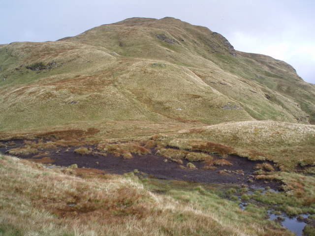
Situated in the southern part of the Grampian Mountains, Beinn Mheadhonach boasts a distinct rugged landscape characterized by steep slopes, rocky crags, and heather-covered moorland. The hill/mountain is composed primarily of ancient geological formations, such as granite and schist, which add to the picturesque scenery.

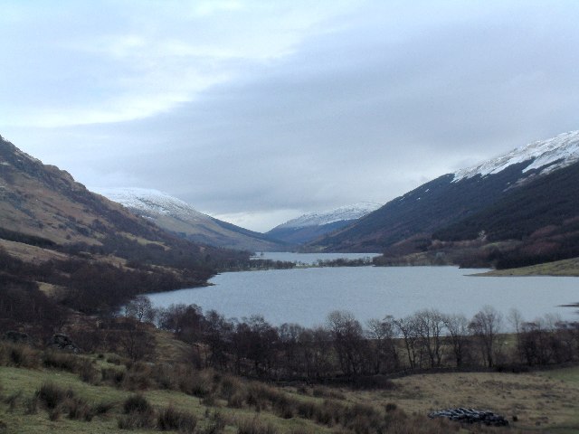
The ascent to Beinn Mheadhonach can be challenging yet rewarding, with multiple routes available for hikers of different skill levels. The most popular starting point is from the village of Pitlochry, where a well-marked path guides visitors through woodlands and open countryside before reaching the mountain's summit. Along the way, hikers can enjoy panoramic views of the surrounding countryside, including the picturesque Loch Tummel and the nearby peaks of Schiehallion and Ben Vrackie.

Wildlife is abundant in the area surrounding Beinn Mheadhonach, with sightings of red deer, golden eagles, and red grouse being relatively common. The hill/mountain also offers opportunities for birdwatching, as various species of birds inhabit the region.

Overall, Beinn Mheadhonach is a captivating and accessible destination for those seeking outdoor adventure and natural beauty. Its diverse terrain, stunning vistas, and rich biodiversity make it a must-visit location in Perthshire, Scotland.

If you have any feedback on the listing, please let us know in the comments section below.

Beinn Mheadhonach Images

Images are sourced within 2km of 56.288906/-4.5147614 or Grid Reference NN4413. Thanks to Geograph Open Source API. All images are credited.

Partly snowed ground south-east of Stob a' Choin. The gently rolling ground is north of Creag Chaorannach and south-east of Stob a' Choin which was the destination on the day the image was recorded; it rises steeply to the left.
The distant snowy peak is Stob Binnein; it lies beyond the upper Balquhidder glen.
Partly snowed ground south-east of Stob a' Choin.
The gently rolling ground is north of Creag Chaorannach and south-east of Stob a' Choin which was the destination on the day the image was recorded; it rises steeply to the left. The distant snowy peak is Stob Binnein; it lies beyond the upper Balquhidder glen.
South from An Stuchd View towards Ben Lomond over the hill country to the north of Loch Katrine.
South from An Stuchd
View towards Ben Lomond over the hill country to the north of Loch Katrine.
Bogs below Stob a' Choin. A boggy area below the south side of Stob a' Choin.
Bogs below Stob a' Choin.
A boggy area below the south side of Stob a' Choin.
Boggy Col One of the many cols on the switchback ridge from Stob Breac to Beinn Mheadhonach between Balquhidder and Loch Katrine - I've been here twice and never seen a soul as the attractions of Ben More, Stob Binnein and others are nearby.
Boggy Col
One of the many cols on the switchback ridge from Stob Breac to Beinn Mheadhonach between Balquhidder and Loch Katrine - I've been here twice and never seen a soul as the attractions of Ben More, Stob Binnein and others are nearby.
Old Deer Fence Rickety old deer fence just south of the summit of An Stuchd looking down into the top of the Invernenty Glen. Just beyond where I was standing I could step right over this fence so it certainly isn't stopping any deer from passing through.
Old Deer Fence
Rickety old deer fence just south of the summit of An Stuchd looking down into the top of the Invernenty Glen. Just beyond where I was standing I could step right over this fence so it certainly isn't stopping any deer from passing through.
Bheinn Mheadhonach Hill on north side of Loch Katrine.
Bheinn Mheadhonach
Hill on north side of Loch Katrine.
Loch Katrine View Loch Katrine from the west fork of Strone Burn - Ben Venue is the prominent peak in the distance.
Loch Katrine View
Loch Katrine from the west fork of Strone Burn - Ben Venue is the prominent peak in the distance.
Frozen burn below Taobh na Coille This unnamed burn drops down the steep hillside into the trees at the south end of the forest.
Frozen burn below Taobh na Coille
This unnamed burn drops down the steep hillside into the trees at the south end of the forest.
Upper Glen Invernenty Although the OS map shows forest covering the whole glen in the south of this square, the flat glen floor is too wet for trees.
Upper Glen Invernenty
Although the OS map shows forest covering the whole glen in the south of this square, the flat glen floor is too wet for trees.
Beinn Mheadhonach from near Letter Burn on moorland south of Beinn Bhreac
Strone Burn near Loch Katrine Beinn Mheadhonach and An Stuchd in the background.
Strone Burn near Loch Katrine
Beinn Mheadhonach and An Stuchd in the background.
Bedrock and man-rock on the Strone Burn near Loch Katrine The dilapidated dyke beyond the burn accounts for man's input.
Bedrock and man-rock on the Strone Burn near Loch Katrine
The dilapidated dyke beyond the burn accounts for man's input.
Meall Gaotach north of Loch Katrine Contouring along the south-east of the hill.
Meall Gaotach north of Loch Katrine
Contouring along the south-east of the hill.
Wee waterfall in the drainage system of Strone Burn on the west slopes of Meall Gaothach
Boulder on the southern slopes of Meall Gaothach near Loch Katrine
Tributary of Strone Burn near Loch Katrine This is almost in a different glen from the Strone but the geology shepherds the burn south and west.
Tributary of Strone Burn near Loch Katrine
This is almost in a different glen from the Strone but the geology shepherds the burn south and west.
Drystane shelter in bend of tributary of Strone Burn near Loch Katrine The map shows a few shielings but none in this exact position. Besides this edifice would barely harbour a stout dog far less a bevy of hielan queans and caillach. Probably of more modern or ad hoc construction and in any case more of a howff than a shieling.
Drystane shelter in bend of tributary of Strone Burn near Loch Katrine
The map shows a few shielings but none in this exact position. Besides this edifice would barely harbour a stout dog far less a bevy of hielan queans and caillach. Probably of more modern or ad hoc construction and in any case more of a howff than a shieling.
The catchment of Strone Burn near Loch Katrine The wall of Meall Gaothach in the background.
The catchment of Strone Burn near Loch Katrine
The wall of Meall Gaothach in the background.
Show me another place!

Beinn Mheadhonach is located at Grid Ref: NN4413 (Lat: 56.288906, Lng: -4.5147614)

Unitary Authority: Stirling

Police Authority: Forth Valley

What 3 Words

///reversed.stiletto.notion. Near Callander, Stirling

Nearby Locations

Beinn Mheadhonach

Related Wikis

Stob a' Choin

Stob a'Choin (869 m) is a mountain in the Grampian Mountains, Scotland, north of Loch Katrine in the Loch Lomond and The Trossachs National Park. The nearest...

Loch Katrine

Loch Katrine (; Scottish Gaelic: Loch Ceiteirein [l̪ˠɔx ˈkʲʰeʰtʲɪɾʲɛɲ] or Loch Ceathairne) is a freshwater loch in the Trossachs area of the Scottish Highlands...

Loch Doine

Loch Doine is a small freshwater loch that lies to the west of Balquhidder in the Trossachs and Teith ward within Stirling council area of Scotland. It...

Meall Mor (Loch Katrine)

Meall Mor (747 m) is a mountain in the Grampian Mountains of Scotland. It lies in the Stirling region, on the northern side of Loch Katrine in the Trossachs...

Nearby Amenities

Located within 500m of 56.288906,-4.5147614
Beinn Mheadhonach
Ele: 514
Munro: no
Natural: peak
Source: OS7
Lat/Long: 56.288632/-4.515039
The data included in this document is from www.openstreetmap.org. The data is made available under ODbL.

Have you been to Beinn Mheadhonach?

Leave your review of Beinn Mheadhonach below (or comments, questions and feedback).