Bow Hill

Hill, Mountain in Ayrshire

Scotland

Bow Hill

Lethanhill War Memorial This striking memorial honours the men from Lethanhill and Burnfoothill who died in the First World War. These old mining villages no longer exist but the memorial is visited every year.
Lethanhill, locally known as “The Hill”, was sited high up on the east side of the Doon Valley to be near the pits where the miners worked.  It once accommodated 1,690 people in 300 homes in 12 rows of colliery houses.  Neighbouring Burnfoothill had 3 rows, providing 69 houses.  Demolition quickly followed the relocation of the population into Patna in 1947, the last residents leaving in 1954. Some of the rows’ foundations are still visible in the forest beside the war memorial.  Although living conditions were hard, there was a strong community spirit and the “Lost Villages” of the Doon Valley are still remembered with great affection.
Lethanhill War Memorial Credit: Mary and Angus Hogg

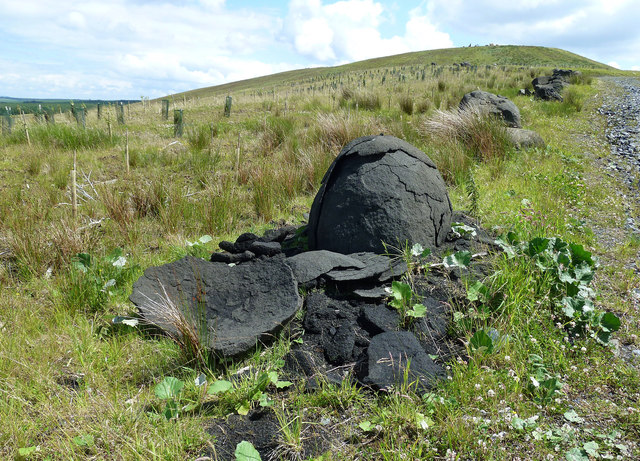
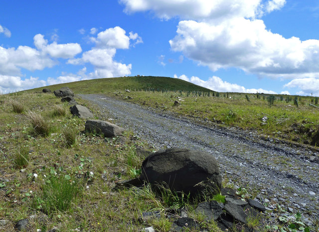
Bow Hill is a prominent landmark located in the picturesque region of Ayrshire, Scotland. Standing at an impressive height of 570 meters (1,870 feet), it is considered one of the highest peaks in the area. Situated within the beautiful Galloway Forest Park, Bow Hill offers stunning panoramic views of the surrounding countryside, making it a popular destination for hikers, nature enthusiasts, and photographers.

Covered in lush greenery, the hill is predominantly composed of granite, which gives it a distinctive rugged appearance. Its slopes are adorned with a diverse range of flora and fauna, including heather, mosses, and various species of birds, making it a haven for wildlife. The hill is also home to a number of walking trails, ranging from gentle strolls to more challenging hikes, providing opportunities for visitors of all fitness levels to explore its natural beauty.

At the summit of Bow Hill, visitors are rewarded with breathtaking vistas that stretch as far as the eye can see. On clear days, it is possible to see the distant peaks of the Southern Uplands, the Isle of Arran, and even the coast of Northern Ireland. Additionally, the hill's strategic location offers a commanding view of the nearby towns and villages, providing a unique perspective of the Ayrshire landscape.

Bow Hill, with its majestic presence and awe-inspiring views, is a must-visit destination for anyone seeking to immerse themselves in the natural wonders of Ayrshire. Whether for a leisurely stroll or a challenging hike, this remarkable mountain promises an unforgettable experience for all who venture to its summit.

If you have any feedback on the listing, please let us know in the comments section below.

Bow Hill Images

Images are sourced within 2km of 55.373933/-4.4564453 or Grid Reference NS4411. Thanks to Geograph Open Source API. All images are credited.

Lethanhill War Memorial This striking memorial honours the men from Lethanhill and Burnfoothill who died in the First World War. These old mining villages no longer exist but the memorial is visited every year.
Lethanhill, locally known as “The Hill”, was sited high up on the east side of the Doon Valley to be near the pits where the miners worked.  It once accommodated 1,690 people in 300 homes in 12 rows of colliery houses.  Neighbouring Burnfoothill had 3 rows, providing 69 houses.  Demolition quickly followed the relocation of the population into Patna in 1947, the last residents leaving in 1954. Some of the rows’ foundations are still visible in the forest beside the war memorial.  Although living conditions were hard, there was a strong community spirit and the “Lost Villages” of the Doon Valley are still remembered with great affection.
Lethanhill War Memorial
This striking memorial honours the men from Lethanhill and Burnfoothill who died in the First World War. These old mining villages no longer exist but the memorial is visited every year. Lethanhill, locally known as “The Hill”, was sited high up on the east side of the Doon Valley to be near the pits where the miners worked. It once accommodated 1,690 people in 300 homes in 12 rows of colliery houses. Neighbouring Burnfoothill had 3 rows, providing 69 houses. Demolition quickly followed the relocation of the population into Patna in 1947, the last residents leaving in 1954. Some of the rows’ foundations are still visible in the forest beside the war memorial. Although living conditions were hard, there was a strong community spirit and the “Lost Villages” of the Doon Valley are still remembered with great affection.
War Memorial at Lethanhill This striking memorial honours the men from Lethanhill and Burnfoothill who died in the First World War. These old mining villages no longer exist but the memorial is visited every year. Ruins of the old mining rows can still be seen along the edge of the wood in the background.
War Memorial at Lethanhill
This striking memorial honours the men from Lethanhill and Burnfoothill who died in the First World War. These old mining villages no longer exist but the memorial is visited every year. Ruins of the old mining rows can still be seen along the edge of the wood in the background.
Old Mine Shaft This big shaft on Lethan Hill is well-secured by modern steel fencing.
Old Mine Shaft
This big shaft on Lethan Hill is well-secured by modern steel fencing.
Dunstonhill Colliery Site This area has a long history of mining. The grey steel fencing encloses an old pit shaft in the next square and the view, which looks towards Kilmein Hill, is taken from a recently re-graded open cast site.
Dunstonhill Colliery Site
This area has a long history of mining. The grey steel fencing encloses an old pit shaft in the next square and the view, which looks towards Kilmein Hill, is taken from a recently re-graded open cast site.
Old Mine Shaft on Knockkippen Moss This area has a long history of mining. This big shaft on Knockkippen Moss is well-secured by modern steel fencing.
Old Mine Shaft on Knockkippen Moss
This area has a long history of mining. This big shaft on Knockkippen Moss is well-secured by modern steel fencing.
Old Mine Shaft on Dunstonhill Colliery Site This big shaft on Knockkippen Moss is well-secured by modern steel fencing.
Old Mine Shaft on Dunstonhill Colliery Site
This big shaft on Knockkippen Moss is well-secured by modern steel fencing.
Dunstonhill Colliery Site View This area has a long history of mining. The land on the left is a recently re-graded and re-seeded open cast operation covering an extensive piece of land.
Dunstonhill Colliery Site View
This area has a long history of mining. The land on the left is a recently re-graded and re-seeded open cast operation covering an extensive piece of land.
Doon Valley Forest View Looking along the woodland edge from the Dunstonhill Colliery site, with a recently re-graded open cast spoil heap on the left in the next square.
Doon Valley Forest View
Looking along the woodland edge from the Dunstonhill Colliery site, with a recently re-graded open cast spoil heap on the left in the next square.
Towards Benquhat Looking along the woodland edge from the Dunstonhill Colliery site, with Benquhat Hill visible in the distance.
Towards Benquhat
Looking along the woodland edge from the Dunstonhill Colliery site, with Benquhat Hill visible in the distance.
Regrading Work at Dunstonhill Colliery Site This area has a long history of mining. The land on the left is a recently re-graded and re-seeded open cast operation covering an extensive piece of land. Only a few years ago, the ground was the moonscape that's so typical of open cast working - see <a href="https://www.geograph.org.uk/photo/3326746">NS4310 : Lethanhill TV Relay Station</a> & <a href="https://www.geograph.org.uk/photo/3326997">NS4310 : Dunstonhill Opencast</a>
Regrading Work at Dunstonhill Colliery Site
This area has a long history of mining. The land on the left is a recently re-graded and re-seeded open cast operation covering an extensive piece of land. Only a few years ago, the ground was the moonscape that's so typical of open cast working - see NS4310 : Lethanhill TV Relay Station & NS4310 : Dunstonhill Opencast
Former Open-Cast Site A lot of work has been undertaken recently on this site near Patna, which has a long history of mining. The pools are well-secured in view of public safety concerns.
Lethanhill, locally known as “The Hill”, was sited high up on the east side of the Doon Valley to be near the pits where the miners worked.  It once accommodated 1,690 people in 300 homes in 12 rows of colliery houses.  Neighbouring Burnfoothill had 3 rows, providing 69 houses.  Demolition quickly followed the relocation of the population into Patna in 1947, the last residents leaving in 1954. Some of the rows’ foundations are still visible in the forest beside the war memorial.  Although living conditions were hard, there was a strong community spirit and the “Lost Villages” of the Doon Valley are still remembered with great affection.  
Lethanhill has changed again with much of the past obliterated by open cast mining operations. Change is still taking place with the typical “moonscape” heaps now being regraded and restored.
Former Open-Cast Site
A lot of work has been undertaken recently on this site near Patna, which has a long history of mining. The pools are well-secured in view of public safety concerns. Lethanhill, locally known as “The Hill”, was sited high up on the east side of the Doon Valley to be near the pits where the miners worked. It once accommodated 1,690 people in 300 homes in 12 rows of colliery houses. Neighbouring Burnfoothill had 3 rows, providing 69 houses. Demolition quickly followed the relocation of the population into Patna in 1947, the last residents leaving in 1954. Some of the rows’ foundations are still visible in the forest beside the war memorial. Although living conditions were hard, there was a strong community spirit and the “Lost Villages” of the Doon Valley are still remembered with great affection. Lethanhill has changed again with much of the past obliterated by open cast mining operations. Change is still taking place with the typical “moonscape” heaps now being regraded and restored.
Restoring Dunstonhill This area was completely changed by the open cast colliery activity. Happily, the site is now being regraded from the former moonscape that’s typical of this type of mining. My older version of the Explorer Map showed the dismantled railway line that was used for the new access road. For a pre-mining view in the opposite direction, see <a href="https://www.geograph.org.uk/photo/404800">NS4311 : Dismantled Railway</a>
Restoring Dunstonhill
This area was completely changed by the open cast colliery activity. Happily, the site is now being regraded from the former moonscape that’s typical of this type of mining. My older version of the Explorer Map showed the dismantled railway line that was used for the new access road. For a pre-mining view in the opposite direction, see NS4311 : Dismantled Railway
Regrading Work at Dunstonhill A lot of regrading work has been done recently on this former open cast colliery. The black boulders mark the edge of a new access road which follows the old dismantled railway. To see what the land was like before the mining, look at <a href="https://www.geograph.org.uk/photo/404864">NS4311 : The Polnessan Burn</a>
Regrading Work at Dunstonhill
A lot of regrading work has been done recently on this former open cast colliery. The black boulders mark the edge of a new access road which follows the old dismantled railway. To see what the land was like before the mining, look at NS4311 : The Polnessan Burn
Polnessan Burn This area was completely changed by the open cast colliery activity. Happily, the site is now being restored from the former moonscape that’s typical of this type of mining.  This view looks down from regraded land above Polnessan Burn. For a pre-mining view of this area, see <a href="https://www.geograph.org.uk/photo/404803">NS4211 : The Polnessan Burn Valley</a>
Polnessan Burn
This area was completely changed by the open cast colliery activity. Happily, the site is now being restored from the former moonscape that’s typical of this type of mining. This view looks down from regraded land above Polnessan Burn. For a pre-mining view of this area, see NS4211 : The Polnessan Burn Valley
Polnessan Burn View This area was completely changed by the open cast colliery activity. Happily, the site is now being restored from the former moonscape that’s typical of this type of mining.  This view looks downstream from regraded land above Polnessan Burn.
Polnessan Burn View
This area was completely changed by the open cast colliery activity. Happily, the site is now being restored from the former moonscape that’s typical of this type of mining. This view looks downstream from regraded land above Polnessan Burn.
Restoring Dunstonhill Open Cast Colliery This area was completely changed by the open cast colliery activity. Happily, the site is now being regraded from the former moonscape that’s typical of this type of mining. The grey-black boulders are a reminder of the past.
Restoring Dunstonhill Open Cast Colliery
This area was completely changed by the open cast colliery activity. Happily, the site is now being regraded from the former moonscape that’s typical of this type of mining. The grey-black boulders are a reminder of the past.
Onion weathering The restoration company has marked the edge of some new tracks with big boulders. The black ones are a soft type of sparkly basalt which breaks down very easily. This shot shows the layers of rock peeling off like the inside of an onion. In some cases, the rock had disintegrated into coarse black sand.
Onion weathering
The restoration company has marked the edge of some new tracks with big boulders. The black ones are a soft type of sparkly basalt which breaks down very easily. This shot shows the layers of rock peeling off like the inside of an onion. In some cases, the rock had disintegrated into coarse black sand.
Going up Dunston Hill The new tracks on this restored open-cast site are shown on the really big scale maps but not yet on the Landranger or Explorer series. This road leads to the restored Dunston Hill which is marked by a set of boulders on the top.
Going up Dunston Hill
The new tracks on this restored open-cast site are shown on the really big scale maps but not yet on the Landranger or Explorer series. This road leads to the restored Dunston Hill which is marked by a set of boulders on the top.
Show me another place!

Bow Hill is located at Grid Ref: NS4411 (Lat: 55.373933, Lng: -4.4564453)

Unitary Authority: East Ayrshire

Police Authority: Ayrshire

What 3 Words

///rips.scribble.bottled. Near Patna, East Ayrshire

Nearby Locations

Bow Hill

Related Wikis

Polnessan

Polnessan (Scottish Gaelic: Poll an Easain, pool on the small waterfall) is a small rural village in East Ayrshire, Scotland. Polnessan has a population...

Cairntable Halt railway station

Cairntable Halt railway station was a railway station serving a rural district and the miners' row of forty-eight houses at the Cairntable Terraces, East...
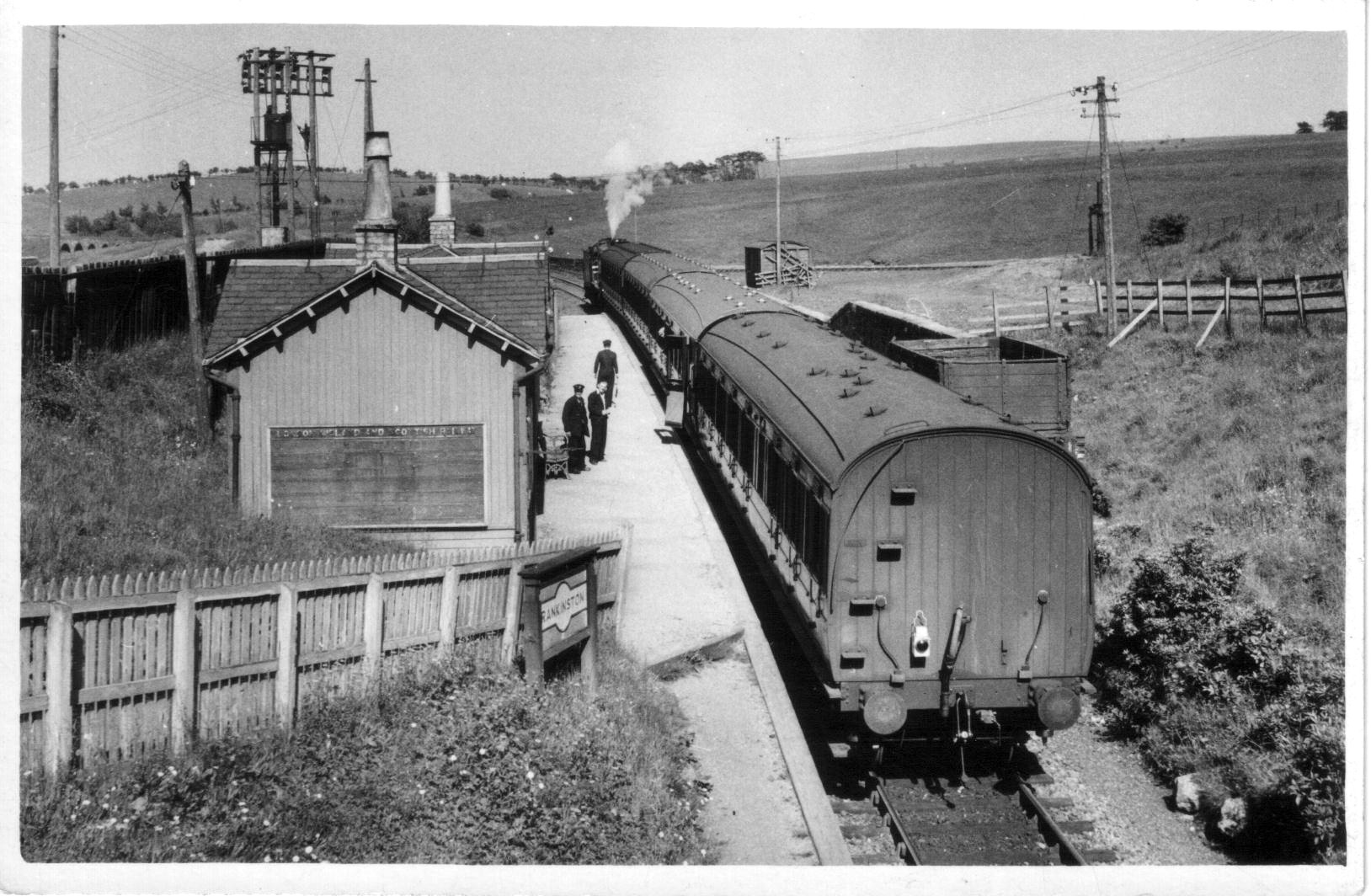
Rankinston

Rankinston is a village in East Ayrshire, Scotland, 3⁄4 mile (1.2 km) off the B730, approximately 12 miles (19 km) south east of the town of Ayr. Rankinston...

Patna railway station (Scotland)

Patna railway station was a railway station serving Patna, East Ayrshire, Scotland. The station was originally part of the Ayr and Dalmellington Railway...

Have you been to Bow Hill?

Leave your review of Bow Hill below (or comments, questions and feedback).