Beinn Dubh

Hill, Mountain in Stirlingshire

Scotland

Beinn Dubh

Beinn Dubh. Summit of Beinn Dubh, a boggy moorland hill rising from the Trossachs forests. View Northwest to Beinn Uamha. This is a cloud inversion. A pool of cold air in the glen is not mixing with warmer air above, the water has condensed below, giving a foggy day in the glens, and a sunny one on the hill.
Beinn Dubh. Credit: Richard Webb

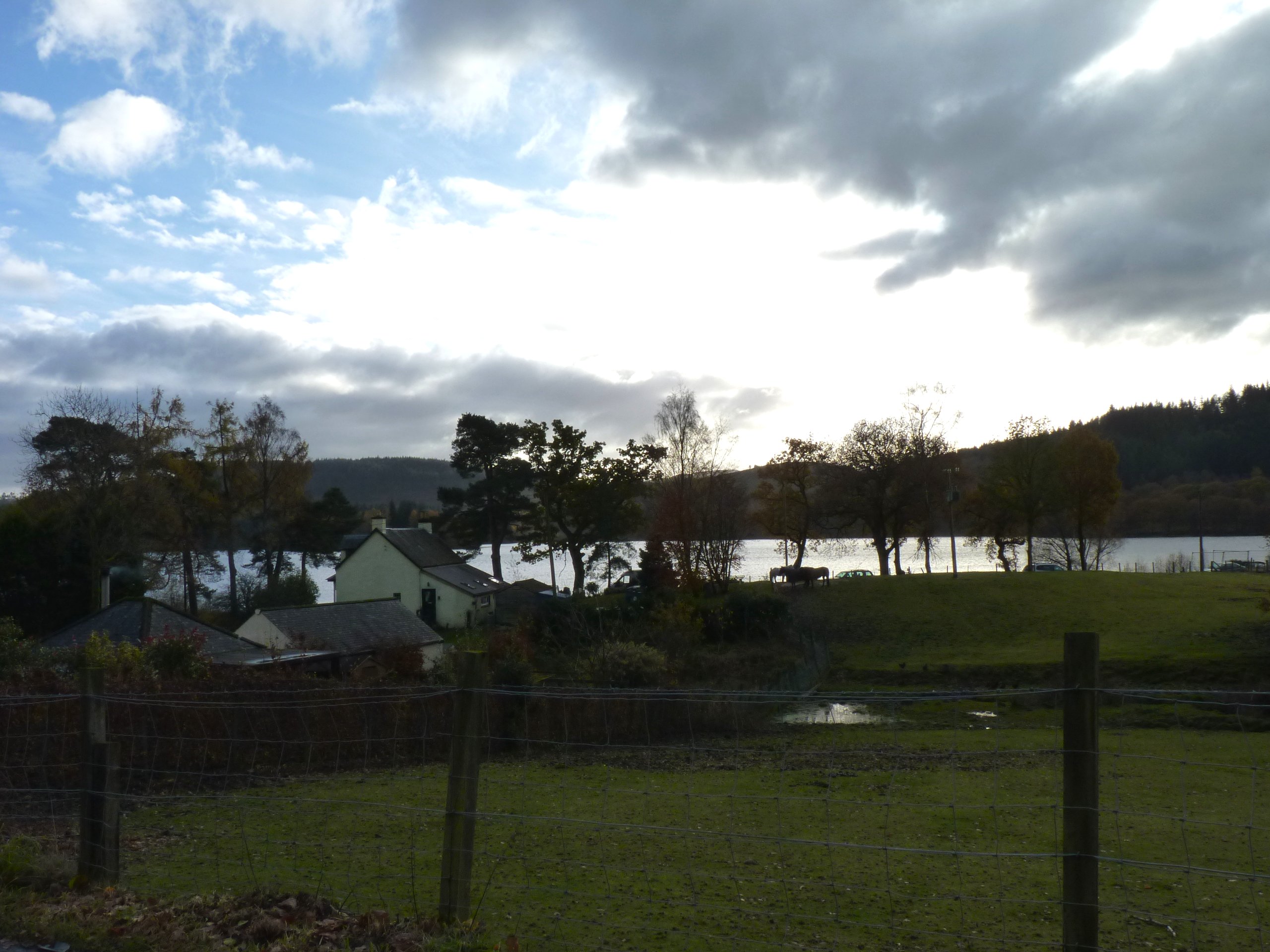
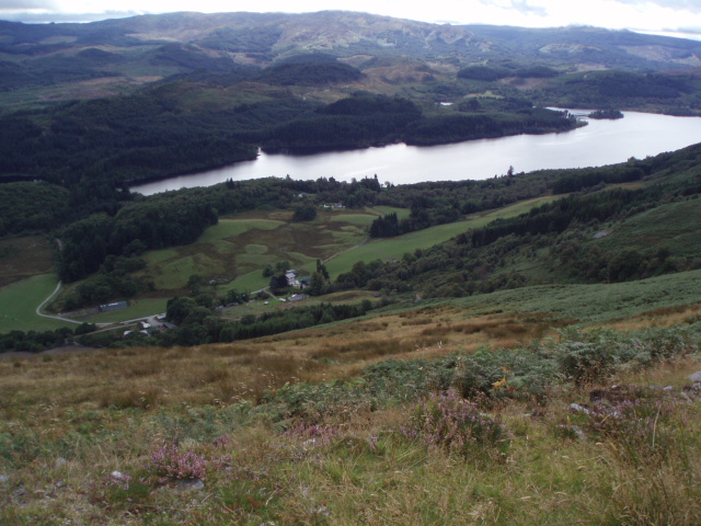
Beinn Dubh is a prominent hill located in Stirlingshire, Scotland. It is part of the Loch Lomond and The Trossachs National Park and stands at an elevation of approximately 642 meters (2,106 feet). The hill is situated in a remote and rugged area, offering stunning panoramic views of the surrounding countryside.

Beinn Dubh is characterized by its steep slopes and rocky terrain, which make it a popular destination for hikers and climbers seeking a challenging outdoor experience. It is accessible via various trails, with the most popular route starting from the village of Drymen. The ascent to the summit can be demanding, but the rewarding vistas make it well worth the effort.

The hill is renowned for its diverse flora and fauna. Its slopes are covered in heather and grasses, providing a habitat for various plant species. Wildlife enthusiasts may spot birds such as golden eagles, buzzards, and ptarmigans, as well as deer and mountain hares.

On a clear day, visitors to Beinn Dubh can enjoy breathtaking views of Loch Lomond, the Trossachs, and the surrounding hills. The summit offers a fantastic vantage point to admire the beauty of the Scottish Highlands and to appreciate the peacefulness of the natural landscape.

Due to its remote location, it is advisable to come prepared with appropriate clothing, equipment, and supplies when venturing to Beinn Dubh. It is also recommended to check weather conditions and follow safety guidelines before embarking on the ascent.

If you have any feedback on the listing, please let us know in the comments section below.

Beinn Dubh Images

Images are sourced within 2km of 56.206383/-4.5736143 or Grid Reference NN4004. Thanks to Geograph Open Source API. All images are credited.

Beinn Dubh. Summit of Beinn Dubh, a boggy moorland hill rising from the Trossachs forests. View Northwest to Beinn Uamha. This is a cloud inversion. A pool of cold air in the glen is not mixing with warmer air above, the water has condensed below, giving a foggy day in the glens, and a sunny one on the hill.
Beinn Dubh.
Summit of Beinn Dubh, a boggy moorland hill rising from the Trossachs forests. View Northwest to Beinn Uamha. This is a cloud inversion. A pool of cold air in the glen is not mixing with warmer air above, the water has condensed below, giving a foggy day in the glens, and a sunny one on the hill.
somewhere deep in the forest..... ...... lurks a circular sandstone inspection shaft, leading down to the underground pipeline that carries Glasgow's water from Loch Katrine.
somewhere deep in the forest.....
...... lurks a circular sandstone inspection shaft, leading down to the underground pipeline that carries Glasgow's water from Loch Katrine.
Across Loch Chon Looking west across Loch Chon from the minor road B829
Across Loch Chon
Looking west across Loch Chon from the minor road B829
Solitary Birch A solitary birch in an area of clear fell with an electricity pylon the only other object standing.
Solitary Birch
A solitary birch in an area of clear fell with an electricity pylon the only other object standing.
Dead Bracken Sun came out briefly and caught this dead bracken at the side of the track. You can see the lower slopes of Ben Lomond and Cruinn a' Bheinn in the distance.
Dead Bracken
Sun came out briefly and caught this dead bracken at the side of the track. You can see the lower slopes of Ben Lomond and Cruinn a' Bheinn in the distance.
Loch Chon Taken in a brief sunny period between heavy showers.
Loch Chon
Taken in a brief sunny period between heavy showers.
Loch Chon A view across Loch Chon on a cold sunny autumn day
Loch Chon
A view across Loch Chon on a cold sunny autumn day
Forest Track Near Loch Chon A forest track running up the west side of Loch Chon
Forest Track Near Loch Chon
A forest track running up the west side of Loch Chon
Burn in Loch Ard Forest A barely visible burn that runs through Loch Ard Forest
Burn in Loch Ard Forest
A barely visible burn that runs through Loch Ard Forest
Track in Loch Ard Forest A track covered in larch needles.
Track in Loch Ard Forest
A track covered in larch needles.
Burn in Loch Ard Forest
Loch Ard Forest An opening in Loch Ard Forest viewed from track that runs along west side of Loch Chon
Loch Ard Forest
An opening in Loch Ard Forest viewed from track that runs along west side of Loch Chon
Track in Loch Ard Forest The track is mostly lined by young larch trees which are about to drop their needles
Track in Loch Ard Forest
The track is mostly lined by young larch trees which are about to drop their needles
Southern Flank of Beinn Dubh The hillside has recently been cleared of trees.  Only a small patch remains to be harvested.
Southern Flank of Beinn Dubh
The hillside has recently been cleared of trees. Only a small patch remains to be harvested.
Loch Dubh Loch Dubh with Ben Lomond to the right
Loch Dubh
Loch Dubh with Ben Lomond to the right
Duchray Water Duchray Water just downstream of Loch Dubh
Duchray Water
Duchray Water just downstream of Loch Dubh
Log Piles in Loch Ard Forest
Duchray Water and Ben Lomond
Show me another place!

Beinn Dubh is located at Grid Ref: NN4004 (Lat: 56.206383, Lng: -4.5736143)

Unitary Authority: Stirling

Police Authority: Forth Valley

What 3 Words

///competing.requests.cocoons. Near Garelochhead, Argyll & Bute

Related Wikis

Loch Dubh (Loch Ard Forest)

Loch Dubh ("Black Loch") is a lochan on the Duchray Water in the western part of Loch Ard Forest in the Central Highlands of Scotland. == Location == Loch...

Loch Chon

Loch Chon is a freshwater loch situated west of the village of Aberfoyle, near the small village of Kinlochard, Stirling, Scotland, UK. Loch Chon lies...

Ben Lomond

Ben Lomond (Scottish Gaelic: Beinn Laomainn, 'Beacon Mountain'), 974 metres (3,196 ft), is a mountain in the Scottish Highlands. Situated on the eastern...

Loch Arklet

Loch Arklet is a freshwater loch and reservoir in the Trossachs area of the Scottish Highlands. It is within the historic county and registration county...

Kinlochard

Kinlochard is a village in Stirling, Scotland. It lies to the western end of Loch Ard. Children in Kinlochard attend Aberfoyle Primary School and eventually...

Loch Lomond and The Trossachs National Park

Loch Lomond and The Trossachs National Park (Scottish Gaelic: Pàirc Nàiseanta Loch Laomainn is nan Tròisichean) is a national park in Scotland centred...

Loch Katrine

Loch Katrine (; Scottish Gaelic: Loch Ceiteirein [l̪ˠɔx ˈkʲʰeʰtʲɪɾʲɛɲ] or Loch Ceathairne) is a freshwater loch in the Trossachs area of the Scottish Highlands...

Loch Ard

Loch Ard (Scottish Gaelic: Loch na h-Àirde) is a loch, located in Loch Lomond and the Trossachs National Park, Stirling council area, Scotland. == Overview... ==

Nearby Amenities

Located within 500m of 56.206383,-4.5736143
Beinn Dubh
Corbett: no
Description: Black hill
Ele: 508
Graham: no
Marilyn: yes
Munro: no
Natural: peak
Prominence: 193
Lat/Long: 56.2063696/-4.5742691
The data included in this document is from www.openstreetmap.org. The data is made available under ODbL.

Have you been to Beinn Dubh?

Leave your review of Beinn Dubh below (or comments, questions and feedback).